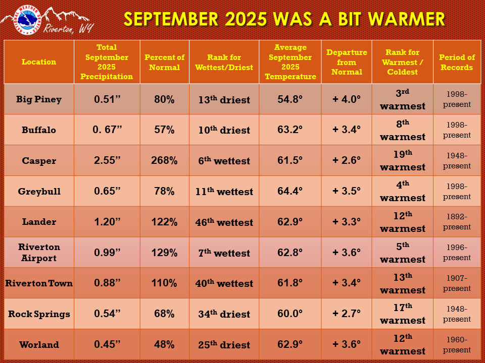
| The September 2025 climate summaries for Big Piney, Buffalo, Casper, Greybull, Lake Yellowstone, Lander, Riverton, Rock Springs, and Worland are now available online. |
 |
|
The month of September started off hot and dry, with a few very isolated storms over the northern mountains. There was also a lot of smoke in the sky from wildfires in western Wyoming and as far away as California. The 4th saw a cold front move through the state and by early evening the temperatures were quite a bit cooler. Friday the 5th had highs 6 to 12 degrees cooler than the day before. The 6th saw several locations with record breaking lows. Casper had a low of 32 degrees, breaking the 1956 record of 33. The weekend did see a warm up again with increased shower activity west of the Divide on Sunday. The middle of the month (11-20th) saw a plethora of afternoon showers and thunderstorms. The storms were in different areas of the state throughout this time frame. The 11th and 12th and 15th even saw Marginal Risk for severe thunderstorms across portions of the Cowboy State. There were definitely some gusty winds and a few reports of small hail did come in. The 11th had one report of 1-inch hail. Lander reported a gust of 69 mph from the southwest on the 10th and Casper had a gust of 67 mph from the south on the 11th. The weather changed again on the 16th and a Freeze warning was issued for Star Valley and Jackson Hole and Sublette County. The 17th, 22nd and 23rd had a few locations with record breaking rainfall. A strong front on the 17th dropped a lot of rain across the area. Another front moved through on the 21st-22nd brought significantly cooler temperatures (10-15 degrees) and widespread rain to the Cowboy state. The 22nd saw the third issuance of Freeze Warning for Jackson Hole, Star Valley, and southern Lincoln County. The 23rd - 25th saw early morning fog. High pressure built back in on the 24th bringing high temperatures 5-15 degrees above normal for the 25th. A quick moving system cooled it a few degrees, but then high pressure took over for warm and dry weather. A cod front moved into the west on the last day of the month bringing rain and isolated thunderstorms with cooler temperatures. Check the CLMs for more specifics on daily records set at the various locations. See the links above for details for individual sites or click here for Water Year Precipitation summaries for more locations. If you would like additional, or more in-depth climate information, please refer to our Climate Page. From the Riverton Home Page, hover over the "Climate and Past Weather" tab, and select the "Local" option. Under the "Observed Weather" tab you can then find the Daily Climate Report (CLI), the Preliminary Monthly Climate Data (CF6), and the Monthly Weather Summary (CLM). The Daily Climate Report will have the weather data for the day (from midnight to 1159 pm). The Monthly Climate Data (CF6) will have this data for each day of the month, compiling all the daily data into one form. There is also a link to the Record Event Reports (RER) and the Annual Climate Report (CLA).
|
|

