Northern Indiana
Weather Forecast Office
A multicell cluster of severe thunderstorms developed during the late afternoon hours of August 8th, 2005 in response to an interesting interaction of stormscale outflow boundaries and weak shortwave trough rotating out of northeast Illinois. This shortwave trough is easily seen in this Water Vapor animation...note the cyclonic circulation present over northeast Illinois which later moves into northwest Indiana.
Animation of visible satellite imagery showed the developing severe multicell cluster well especially with the upscale anvil growth and overshooting top which developed with the most severe storm in southern Elkhart county.
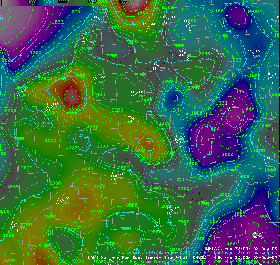
Conditions were quite favorable for surface based convection Monday afternoon as shown in the image which shows Convective Available Potential Energy (CAPE) and lifted index (LI) and surface observations across the area at 5 pm est August 8th, 2005.
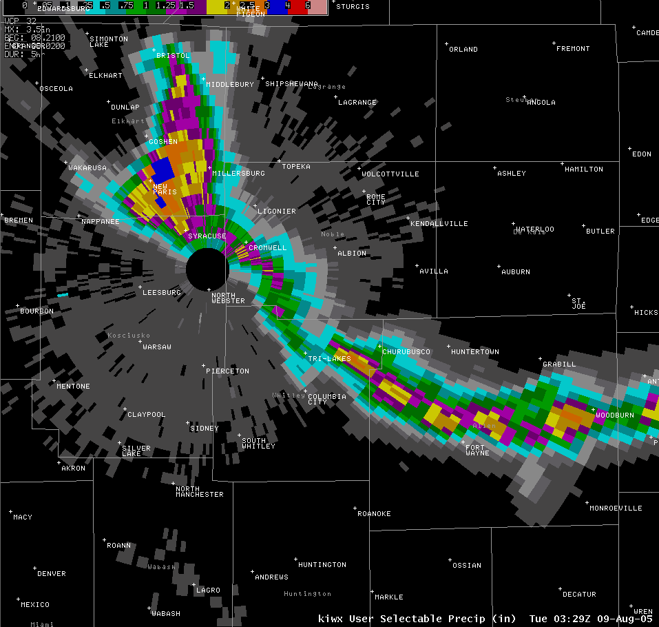
This 0.5 degree radar reflectivity animation from the National Weather Service Doppler radar in North Webster shows the rapid development and intensification of the initial multicell storm cluster as it develops northwestward out of Allen county Indiana in the late afternoon. Note the vigorous storm development which occurs over southern Elkhart county late in the loop...this storm produced widespread large hail up to golfball size and which covered the ground in southern Goshen and rainfall amounts in excess of 3 inches in only one hour.
Additional storm reports can be found in this LOCAL STORM REPORT.
PRELIMINARY LOCAL STORM REPORT...SUMMARY
NATIONAL WEATHER SERVICE NORTHERN INDIANA
751 PM EST MON AUG 08 2005

..TIME...   ...EVENT...      ...CITY LOCATION...     ...LAT.LON...
..DATE...   ....MAG....      ..COUNTY LOCATION..ST.. ...SOURCE....
            ..REMARKS..

0503 PM     HAIL             FORT WAYNE              41.07N 85.14W
08/08/2005  1.00 INCH        ALLEN              IN   AMATEUR RADIO

            IPFW CAMPUS ON EAST SIDE OF TOWN

0506 PM     HAIL             1 E FORT WAYNE          41.07N 85.12W
08/08/2005  0.88 INCH        ALLEN              IN   EMERGENCY MNGR

0550 PM     HAIL             TRI-LAKES               41.22N 85.48W
08/08/2005  1.00 INCH        WHITLEY            IN   EMERGENCY MNGR

            NICKEL TO QUARTER SIZE

0620 PM     HAIL             6 SE GOSHEN             41.52N 85.75W
08/08/2005  1.00 INCH        ELKHART            IN   AMATEUR RADIO

0628 PM     HAIL             3 SE GOSHEN             41.55N 85.79W
08/08/2005  1.25 INCH        ELKHART            IN   AMATEUR RADIO

0635 PM     HAIL             3 SE GOSHEN             41.55N 85.79W
08/08/2005  1.75 INCH        ELKHART            IN   TRAINED SPOTTER

0720 PM     FLOOD            2 SE GOSHEN             41.56N 85.81W
08/08/2005                   ELKHART            IN   BROADCAST MEDIA

            US 33 WATER OVER ROAD

0730 PM     FLASH FLOOD      5 SE GOSHEN             41.53N 85.77W
08/08/2005                   ELKHART            IN   AMATEUR RADIO

            COUNTY ROAD 31 AND US 33 AT FAIRFIELD HIGH SCHOOL ROAD
            IMPASSABLE IN PLACES DUE TO WATER OVER ROAD


&&

$$

ASTEVENS
Page created by TH on Monday August 8, 2005 10:30 PM EST
Hazards
Heat Related
Winter Related
Watch/Warning
Outlook
Storm Reports
Storm Prediction Center
Submit a Report
Event Ready
Climate
FWA Daily
SBN Daily
FWA Monthly
SBN Monthly
CoCoRaHS
Spring Frost Climatology
Fall Frost Climatology
Severe Climatology
Local Information
Skywarn
COOP
Our Office
WSR-88D
Headline Criteria
NOAA Weather Radio
Weather History
Probabilistic Snowfall
Public Information Statement
Social Media Feeds
Weather Events Page
US Dept of Commerce
National Oceanic and Atmospheric Administration
National Weather Service
Northern Indiana
7506 E 850 N
Syracuse, IN 46567
574-834-1104
Comments? Questions? Please Contact Us.

