Event Overview
A major snowstorm affected most of Eastern North Carolina on the evening of Friday February 12 and Saturday morning February 13, 2010, dumping as much as 9 inches of snow across the region (Figure 1), with the heaviest amounts near the coast. The storm was the result of a strong area of low pressure developing rapidly off the Florida coast and quickly strengthening as it moved off the North Carolina coast. The snowfall was the heaviest in the area since January 23, 2003. The storm produced a heavy wet snow, which produced many broken limbs across the eastern portion of North Carolina.
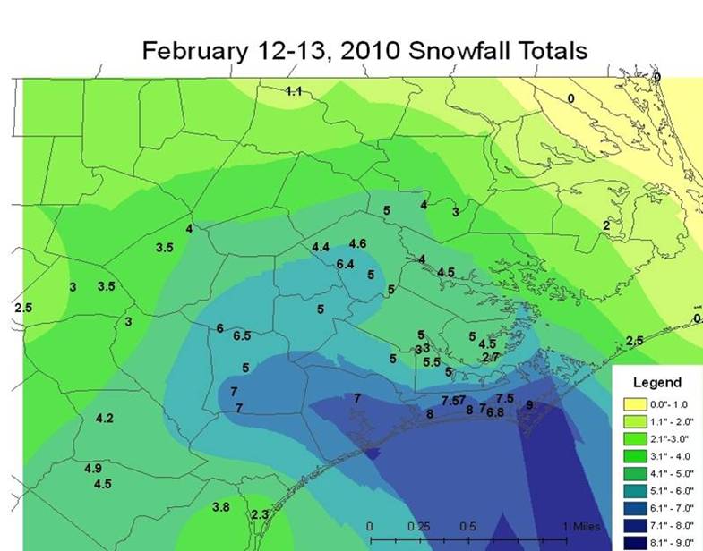
Figure 1. Snowfall Amounts from the February 12-13, 2010 Snowstorm. (Map courtesy Belkys Melendez)
Synoptic Overview
A strong mid-level shortwave moved out of the Desert Southwest and progressed eastward taking on a bit more of a neutral tilt as it crossed east Texas late Thursday evening February 11th (Figure 2) as surface low development occurred across the western Gulf of America. Widespread snow developed from east Texas across central and northern sections of Louisiana and Mississippi Thursday evening. Dallas, TX had a record storm total snowfall of 12.6 inches. As the storm progressed eastward, widespread 6 to 8 inch snow amounts were noted over central and northern Louisiana and Mississippi Thursday night into early Friday morning February 12th.
Continued development of the northern Gulf surface low, accompanied by intensification of a mid-level jet streak over the western Gulf of America, led to increasing development of heavy snow by Friday morning across parts of east central and southeast Mississippi through parts of central and southern Alabama. Light snow accumulations were noted as far south as Mobile, Alabama and the far western Florida Panhandle.
Another strong mid-level shortwave over Louisiana and Mississippi continued east and increased lift across Central Alabama through Central Georgia Friday afternoon (Figure 3). As the surface low over the Gulf developed east and deepened toward evening off the east coast of Florida, snowfall amounts of 3 to 6 inches were noted over Central and Northern Georgia and snow spread into much of South Carolina late Friday afternoon.
An intense vorticity maximum moved from southeastern Georgia and lifted northeastward into the eastern Carolinas Friday evening (Figure 4). As the surface low crossed Florida and moved up the coast, the vorticity center resulted in deepening cyclogenesis off the South Carolina coast. As the storm developed, very impressive 7-8 mb hourly pressure falls were observed just off the North Carolina coast Friday evening. Snow started to fall in the Newport/Morehead City County Warning Area (CWA), between 8 and 9 pm (01z and 02z) Friday evening February 12th. Forecast soundings showed that snow developed in the favorable temperature dendritic growth zone. A mesoscale discussion from the Storm Prediction Center noted that “snow rates around 1 inch were possible within heavier snow bands...and would possibly persist for 3 to 6 hours. “
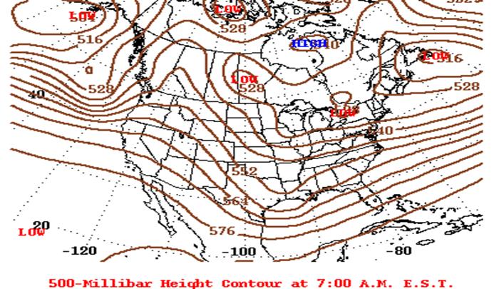
Figure 2. 500 mb Heights at 7 am February 12th showing upper trough over eastern Texas.
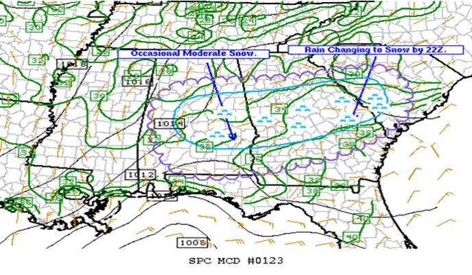
Figure 3. Storm Prediction Center Composite Chart from Friday Afternoon Feb 12th, 2010 showing area of moderate snow.
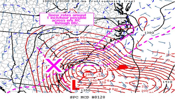
Figure 4. Storm Prediction Center Composite Chart from Friday Evening February 12th shows strong Vorticity center moving offshore with rapid strengthening of surface low pressure off the northeast Florida coast.
The surface low deepened and moved off the Carolina coast by early Saturday morning (Figure 5) with the snowfall gradually ending from the west by mid morning as the low accelerated away from the area. When skies cleared by Saturday afternoon, visible satellite showed the widespread snow cover over the region (Figure 6.)
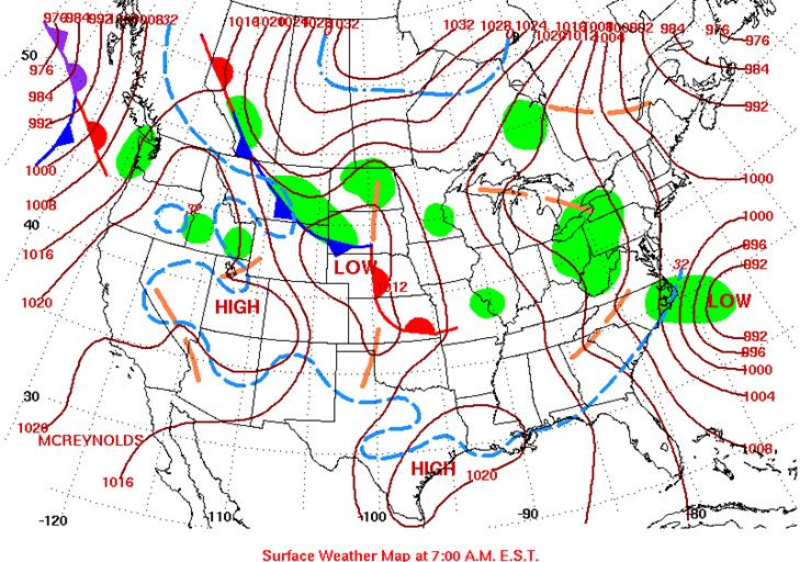
Figure 5. Surface Analysis at 7 am February 13th, 2010 showing deepening low pressure off the North Carolina coast.
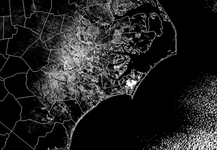
Figure 6. Visible satellite imagery from Saturday February 13th showing widespread snow cover across Eastern North Carolina.
Sources
NOAA Daily Weather Maps Project
Storm Prediction Center
Snow Pictures from Eastern North Carolina
Photos courtesy of: Chris Collins, Mark Willis, New Bern Sun Journal

National Weather Service in Newport on the morning of February 13, 2010

Weighted down tree limbs in Morehead City on the morning of February 13, 2010

New Bern

Tree bending due to the weight of the snow in Craven County, February 13, 2010
Case Study Team:
Chris Collins
Belkys Melendez


 Map View
 Weather Hazard Briefing (when applicable)
 Forecaster Discussion
 Marine
 Text Products
.png) Skywarn
Skywarn Submit Storm Reports
 Coastal Flood
.png) Surf Forecast/Rip Currents
Surf Forecast/Rip Currents