Prolonged Coastal Flood/Heavy Rainfall Event
October 2-6, 2015
Summary
The combination of Hurricane Joaquin passing well to the east, an upper level low pressure system off the Southeast U.S. coast and a stalled cold front led to an event that produced a wide variety of impacts across eastern North Carolina during the first week of October, 2015. Major coastal flooding, very heavy rainfall and strong winds impacted much of eastern North Carolina for several days. This is the same storm system that brought historic rainfall amounts to the Charleston and Columbia areas in South Carolina, as well as parts of southeast North Carolina.
Coastal Flooding
Water levels were already elevated across eastern North Carolina due to some of the highest astronomical tides of the year. These high tides coupled with persistent gusty east to northeast winds resulted in areas of moderate to major coastal flooding along the Outer Banks and many sound-side locations. Water level rises of 2 to 4 feet above normal, with locally higher values were observed. On the Northern Outer Banks, Highway 12 was closed at Kitty Hawk (Figure 1) due to ocean overwash and dune breaches as major flooding occurred (Figure 2). Many streets in and around downtown Columbia flooded, roads around Aurora in Beaufort County (Figure 3) became impassible, water rescues were conducted for 3 individuals near Hobucken in Pamlico County, and moderate to major coastal flooding was observed throughout Downeast Carteret County, especially around Cedar Island (Figure 4), and in the downtown areas of Beaufort (Figure 5) and Morehead City (Figure 6). Major flooding and beach erosion was also reported at North Topsail Beach.
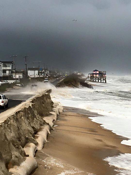
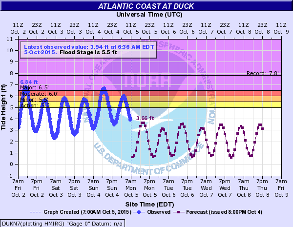
Figure 1. Coastal Flooding at Kitty Hawk Figure 2. Duck Tide Gauge showing Major Flooding on Oct. 2, 2015
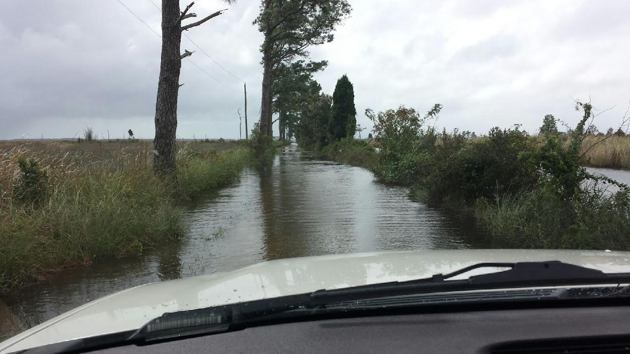
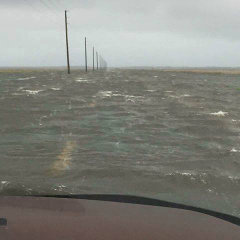
Figure 3. Flooding near Bath, Beaufort County. Figure 4. Highway 12 near Cedar Island underwater.

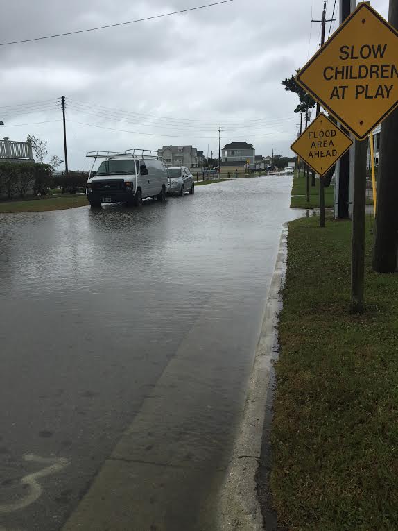
Figure 5. Front Street in Downtown Beaufort flooding. Figure 6. Shepherd Street in Downtown Morehead City flooding.
Heavy Rainfall
For the period from October 2 through 6, 2015, rainfall totals of 6 to 12 inches occurred across eastern North Carolina with the heaviest totals near the coast. Historic flooding was observed in South Carolina, where Charleston reported upwards of 2 feet of rainfall (Figures 7 and 8). Combined with another heavy rainfall event the previous week, eastern North Carolina recorded from 10 to upwards of 20 inches of rainfall. The Beaufort Airport recorded 21.57 inches of rain in the period from September 25 through October 6, 2015 (Figure 9).
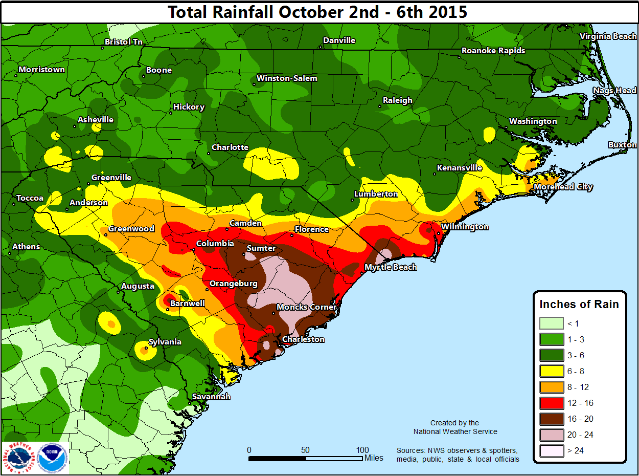
Figure 7. Rainfall Totals from October 2 through 6, 2015
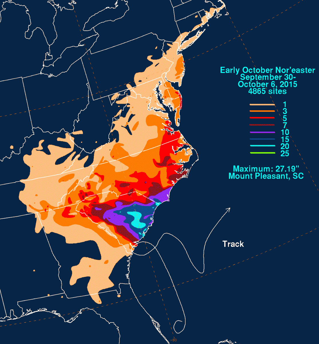
Figure 8. Rainfall Totals from September 30 through October 6, 2015 (Courtesy David Roth, Weather Prediction Center).
...RAINFALL REPORTS SEPTEMBER 25 2015 THROUGH OCTOBER 6 2015... ASOS STATIONS (0000 EDT 9/25/15 TO 0800 EDT 10/6/15) LOCATION AMOUNT MICHAEL J SMITH AP(KMRH) 21.57 IN BILLY MITCHELL AP(KHSE) 17.54 IN CHERRY POINT MCAS (KNKT) 13.01 IN COASTAL CAROLINA AP (KEWN) 9.43 IN NEW RIVER MCAS (KNCA) 9.37 IN COOP STATIONS (0000 EDT 9/25/15 TO 0800 EDT 10/6/15) ATLANTIC BEACH (ATBN7) 15.96 IN NEWPORT WFO (MHXN7) 14.15 IN GREENVILLE (GREN7) 11.93 IN COCORAHS STATIONS (0000 EDT 9/25/15 TO 0800 EDT 10/6/15) ...CARTERET COUNTY... HARKERS ISLAND 3.2 NE 21.88 IN SMYRNA 0.3 ESE 21.02 IN MOREHEAD CITY 2.4 WNW 19.63 IN BEAUFORT 6.5 N 19.62 IN MOREHEAD CITY 0.6 NW 19.45 IN PINE KNOLL SHORES 1.4 E 17.14 IN MOREHEAD CITY 6 WNW 15.09 IN NEWPORT 0.2 SW 14.95 IN NEWPORT 2.5 W 13.65 IN INDIAN BEACH 13.24 IN ...CRAVEN COUNTY... HAVELOCK 7.3 E 16.66 IN HAVELOCK 6.3 ENE 14.90 IN NEW BERN 7.3 ESE 11.97 IN ...ONSLOW COUNTY... HOLLY RIDGE 4.8 ENE 12.94 IN HUBERT 4.3 SE 12.87 IN HUBERT 4.9 SE 12.58 IN SWANSBORO 3.3 NW 11.26 IN ...PITT COUNTY... GREENVILLE 3.3 W 11.38 IN GREENVILLE 4.7 WNW 11.00 IN GREENVILLE 5.7 NW 10.89 IN |
| Figure 9. Rainfall Reports from September 25 through October 6, 2015. |
Strong Wind
The pressure gradient between developing surface low pressure off the Georgia/South Carolina coast, and high pressure over New England led to a prolonged period of persistent gusty northeast to east winds across eastern North Carolina and the adjacent coastal waters and sounds (Figure 10). This acted in concert with already elevated water levels due to high astronomical tides to greatly increase water levels.

Figure 10. Peak Winds Gusts across North Carolina, October 1 through 5, 2015.
...WIND REPORTS FROM THE NOREASTER LOW THAT IMPACTED OUR AREA OCTOBER 4TH THROUGH OCTOBER 5TH 2015... LOCATION SPEED TIME/DATE LAT/LON ...BEAUFORT COUNTY... BUNYAN RAWS 48 MPH 0418 PM 10/04 35.52N/76.93W WASHINGTON (OCW AWOS) 29 MPH 0415 PM 10/04 35.57N/77.05W ...CARTERET COUNTY... PINEY ISLAND (NBT ASOS) 52 MPH 0319 PM 10/05 35.02N/76.47W CEDAR ISLAND RAWS 39 MPH 0225 PM 10/04 34.96N/76.28W BEAUFORT (MRH ASOS) 39 MPH 1206 PM 10/05 34.73N/76.66W CROATAN RAWS 39 MPH 0105 PM 10/05 34.76N/76.90W ...CRAVEN COUNTY... CHERRY POINT (NKT ASOS) 44 MPH 0357 PM 10/04 34.90N/76.88W NEW BERN (EWN ASOS) 39 MPH 0221 PM 10/05 35.07N/77.04W NEW BERN RAWS 29 MPH 0417 PM 10/04 35.10N/77.11W ...DARE COUNTY... MANTEO (MQI AWOS) 44 MPH 1215 PM 10/04 35.92N/75.70W DARE CO GNRY RAN (2DP AWOS) 41 MPH 0146 PM 10/04 35.67N/75.89W DARE BOMB RANGE RAWS 41 MPH 0328 PM 10/04 35.76N/75.87W FRISCO (HSE ASOS) 37 MPH 0459 PM 10/05 35.23N/75.62W KILL DEVIL HILLS (FFA AWOS) 32 MPH 1255 PM 10/04 36.03N/75.67W ...DUPLIN COUNTY... KENANSVILLE (DPL AWOS) 28 MPH 1235 PM 10/05 35.00N/77.98W ...LENOIR COUNTY... KINSTON (ISO AWOS) 32 MPH 0355 AM 10/05 35.33N/77.62W ...MARINE REPORTING STATIONS... 30 SE NEW RIVER INLET 56 MPH 1008 AM 10/05 34.20N/77.00W CAPE LOOKOUT 54 MPH 1200 PM 10/05 34.62N/76.52W FT MACON (WXFLOW) 51 MPH 1128 AM 10/05 34.70N/76.69W ALLIGATOR BRIDGE (WXFLOW) 51 MPH 0831 AM 10/05 35.90N/76.01W DUCK FRF RESEARCH PIER 49 MPH 0336 PM 10/04 36.18N/75.75W JENETTES PIER (WXFLOW) 48 MPH 0910 AM 10/05 35.91N/75.59W OCRACOKE (WXFLOW) 47 MPH 0140 PM 10/05 35.14N/76.01W DIAMOND SHOALS BUOY 43 MPH 0350 PM 10/05 35.01N/75.40W OREGON INLET 42 MPH 0124 PM 10/04 35.79N/75.55W BEAUFORT 41 MPH 1148 AM 10/05 34.72N/76.67W ...ONSLOW COUNTY... JACKSONVILLE (NCA ASOS) 37 MPH 0137 PM 10/05 34.72N/77.43W RICHLANDS (OAJ AWOS) 35 MPH 0935 PM 10/04 34.83N/77.61W HOFFMAN RAWS 32 MPH 0110 PM 10/05 34.82N/77.32W ...PITT COUNTY... GREENVILLE (PGV AWOS) 32 MPH 0155 PM 10/04 35.64N/77.39W |
Peak Winds Observed October 4-5, 2015.
Sources
Southeast River Forecast Center
National Weather Service Offices in Raleigh, Wilmington and Charleston, SC.
Weather Prediction Center


 Map View
 Weather Hazard Briefing (when applicable)
 Forecaster Discussion
 Marine
 Text Products
.png) Skywarn
Skywarn Submit Storm Reports
 Coastal Flood
.png) Surf Forecast/Rip Currents
Surf Forecast/Rip Currents