Wind/Coastal Flood/Low Water Event - March 2-5, 2018
A prolonged period of strong west to northwest winds produced major impacts on eastern North Carolina. These included significant ocean overwash and coastal flooding from the Ocracoke area north to Duck along the Outer Banks. This storm also produced record low water levels in the Neuse and Pamlico Rivers.
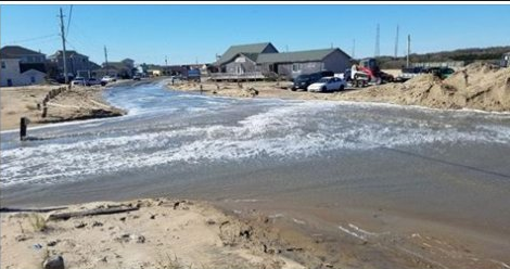
Overwash on the Outer Banks after the March 2, 2018 storm.
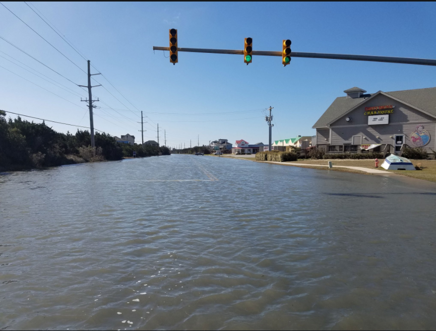
Coastal Flooding at Avon, NC, March 5, 2018.
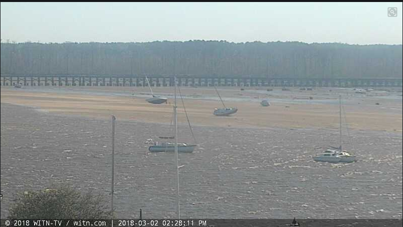
Low Water on the Pamlico River, Washington, NC March 2, 2018 (Courtesy WITN TV).
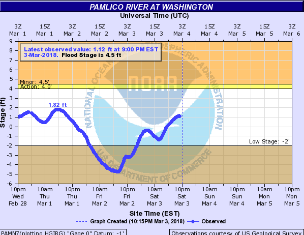
Hydrograph showing the water levels some 5 feet below normal on the Pamlico River in Washington, March 2, 2018.
Public Information Statement National Weather Service Newport/Morehead City NC 952 PM EST Fri Mar 2 2018 ...Wind Reports... Location Speed Time/Date Provider ...North Carolina... ...Beaufort County... Bunyan RAWS 47 MPH 0313 PM 03/02 RAWS Washington (OCW AWOS) 40 MPH 0915 AM 03/02 AWOS ...Carteret County... Cedar Island Ferry 64 MPH 0530 PM 03/02 NWS Fort Macon (WxFlow) 57 MPH 1123 AM 03/02 WXFLOW Beaufort (MRH ASOS) 55 MPH 0535 AM 03/02 ASOS Cape Lookout 47 MPH 0300 PM 03/02 MARITIME 3 NW Indian Beach 47 MPH 1034 AM 03/02 CWOP Croatan RAWS 46 MPH 0405 PM 03/02 RAWS 1 WNW Morehead City 45 MPH 0520 PM 03/02 CWOP North River (WxFlow) 43 MPH 1216 PM 03/02 WXFLOW Beaufort 42 MPH 0442 PM 03/02 NWLON Otway 40 MPH 0454 PM 03/02 CWOP Cape Carteret 36 MPH 1238 PM 03/02 CWOP ...Craven County... Cherry Point (NKT ASOS) 62 MPH 0526 AM 03/02 ASOS New Bern (EWN ASOS) 51 MPH 0208 PM 03/02 ASOS 1 N Trent Woods 49 MPH 0412 PM 03/02 CWOP 2 SSW Havelock 43 MPH 0426 PM 03/02 CWOP 6 SSE Minnesott Beach 35 MPH 0329 PM 03/02 CWOP ...Dare County... Oregon Inlet CG (WxFlow) 66 MPH 0745 AM 03/02 WXFLOW Stumpy Point (WxFlow) 62 MPH 0750 PM 03/02 WXFLOW Oregon Inlet (WxFlow) 57 MPH 0850 AM 03/02 WXFLOW Avon (WxFlow) 54 MPH 0704 PM 03/02 WXFLOW Nags Head (WxFlow) 54 MPH 0615 PM 03/02 WXFLOW Oregon Inlet 53 MPH 0854 AM 03/02 NWLON Hatteras High (WxFlow) 52 MPH 0621 PM 03/02 WXFLOW Dare Co Gnry Ran (K2DP AWOS) 49 MPH 1004 AM 03/02 AWOS Rodanthe 49 MPH 0404 AM 03/02 CWOP Buxton (WxFlow) 49 MPH 1051 AM 03/02 WXFLOW Frisco (HSE ASOS) 48 MPH 0705 PM 03/02 ASOS Dare Bomb Range RAWS 47 MPH 0228 PM 03/02 RAWS Southern Shores 46 MPH 0916 PM 03/02 CWOP Kill Devil Hills (FFA AWOS) 46 MPH 0715 PM 03/02 AWOS Manteo (MQI AWOS) 45 MPH 0635 AM 03/02 AWOS Cape Hatteras Lighthouse 41 MPH 0241 PM 03/02 CWOP ...Duplin County... Kenansville (DPL AWOS) 43 MPH 0235 PM 03/02 AWOS ...Hyde County... 4 NE Engelhard 56 MPH 0855 AM 03/02 MESOWEST Fairfield RAWS 41 MPH 1117 AM 03/02 RAWS ...Lenoir County... Kinston (ISO AWOS) 40 MPH 0729 PM 03/02 AWOS ...Onslow County... Jacksonville (NCA ASOS) 52 MPH 0358 PM 03/02 ASOS 1 W Jacksonville 44 MPH 0243 PM 03/02 CWOP 1 SSE Sneads Ferry 41 MPH 0341 PM 03/02 CWOP Hoffman RAWS 40 MPH 0210 PM 03/02 RAWS Richlands (OAJ AWOS) 37 MPH 0852 AM 03/02 AWOS Sandy Run RAWS 36 MPH 0519 PM 03/02 RAWS 6 WNW New River Station 36 MPH 0101 PM 03/02 CWOP ...Pamlico County... 1 WSW Oriental 39 MPH 0721 AM 03/02 CWOP ...Pitt County... Greenville (PGV AWOS) 44 MPH 0135 PM 03/02 AWOS ...Washington County... 2 SW Creswell 45 MPH 0937 AM 03/02 CWOP Pocosin Lakes RAWS 45 MPH 1117 AM 03/02 RAWS ...Maritime Stations... Jennettes Pier (WxFlow) 63 MPH 0745 PM 03/02 WXFLOW Duck FRF Research Pier 61 MPH 0900 PM 03/02 NWLON Diamond Shoals Buoy 60 MPH 0800 PM 03/02 MARITIME Pamlico Sound (WxFlow) 60 MPH 0952 AM 03/02 WXFLOW Ocracoke (WxFlow) 58 MPH 1122 AM 03/02 WXFLOW Real Slick (WxFlow) 56 MPH 0750 PM 03/02 WXFLOW Frisco Woods (WxFlow) 55 MPH 0640 PM 03/02 WXFLOW 25 ENE Rodanthe 51 MPH 0900 AM 03/02 MARITIME Buoy 30SE New River Inlet 47 MPH 0808 AM 03/02 MARITIME && Observations are collected from a variety of sources with varying equipment and exposures. We thank all volunteer weather observers for their dedication. Not all data listed are considered official. |


 Map View
 Weather Hazard Briefing (when applicable)
 Forecaster Discussion
 Marine
 Text Products
.png) Skywarn
Skywarn Submit Storm Reports
 Coastal Flood
.png) Surf Forecast/Rip Currents
Surf Forecast/Rip Currents