Morehead City National Weather Service
Marine Zone Expansion to 60 NM Offshore
OVERVIEW
Beginning on or about April 16, 2026, National Weather Service (NWS) Weather Forecast Office (WFO) Newport/Morehead City, NC (MHX) will assume forecast, watch, and warning responsibility for the coastal waters from South of Currituck Beach Light to Surf City, NC from 20 to 60 Nautical Miles (NM) offshore. Routine forecast services for these waters were previously the responsibility of the Ocean Prediction Center (OPC), with warning responsibility divided between WFO MHX and OPC. This change is part of a regional improvement that will result in all forecasts and warnings for coastal waterways within 60 NM of shore originating from the local WFO across the entire Contiguous United States (CONUS). There will be no change to the current forecast and warning services provided by WFO MHX for coastal waterways within 20 NM of shore.
JUSTIFICATION
The coastal waterways are lifelines of commerce in eastern North Carolina, frequented by commercial, recreational, and research vessels year-round. Major shipping lanes pass just off our coast, with ships passing just east of Diamond Shoals and Cape Lookout Shoals to minimize the distance needed to traverse between critical ports in the Northeast/Mid-Atlantic and the Southeast. Additionally, fishermen often leave local ports bound for offshore fishing sites such as artificial reefs and the Gulf Stream. These activities primarily take place within 60 NM of shore, with mariners depending on reliable weather forecasts from the National Weather Service to ensure the safety of themselves and their crew, passengers, and cargo while on the water.

The above graphic shows that the majority of fishing and recreational vessel activity is within 40 NM of shore, with vessels often traversing beyond the previous 20 NM offshore extent of forecasts from WFO MHX.
.png)
The Graphic above shows that most cargo and tanker vessels traverse about 15-60 NM offshore of the Outer Banks. Expanding WFO MHX forecast and warning responsibility to 60 NM offshore will cover significantly more commercial traffic.
With the redesignation of all forecast and warning responsibility for the coastal waters within 60 NM of shore to the local WFO, users will experience these benefits:
Improved forecast service continuity, with local WFO’s now responsible for issuing routine forecasts and warnings for all marine waters out to 60 NM offshore for the entire CONUS.
Increased number of forecast parameters with temperature, precipitation chances, and weather type among the parameters that are now available for mariners from 20 to 60 NM offshore out to 5 days in the future.
Improved forecast resolution, with point and click forecast capability now enabling mariners to get hourly forecasts for specific points (such as offshore artificial reefs) anywhere within 60 NM of shore out to 5 days in the future.
Expanded suite of short and long-fused watch/warning and advisory products to alert mariners to the potential for a variety of hazardous weather conditions.
WFO’s now have the capability to deliver Impact-based Decision Support Services (IDSS) to partners in support of incident response for incidents that occur anywhere within 60 NM of shore.
ZONE CHANGE DESCRIPTIONS
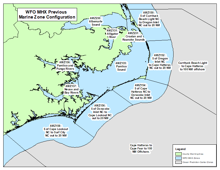
The above graphic shows the previous alignment of marine zones with blue zones being the responsibility of the local WFO.
.png)
The above graphic shows the new alignment of marine forecast zones with light and dark blue zones now being the responsibility of the local WFO. All coastal waters to 60 NM offshore from south of Currituck Light to Surf City, NC will now receive forecasts and warnings from NWS MHX.
| AREA | PREVIOUS ZONE NAME(S) | PREVIOUS ZONE NUMBER(S) | NEW ZONE NAME | NEW ZONE NUMBER |
| Ocean Waters from the Dare/Currituck County Line to Oregon Inlet, from 20 to 60 NM offshore |
Waters from Currituck Beach Light to Oregon Inlet NC from 20 to 40 NM (MHX), Cape Charles Light to Currituck Beach Light to 100 NM offshore (Partial, OPC) Currituck Beach Light to Cape Hatteras to 100 NM offshore (Partial, OPC) |
AMZ170
ANZ828
ANZ830 |
Waters from S of Currituck Beach Light to Oregon Inlet NC from 20 to 60 NM | AMZ180 |
| Ocean Waters from Oregon Inlet to Cape Hatteras, from 20 to 60 NM offshore |
Waters from Oregon Inlet to Cape Hatteras NC from 20 to 40 NM (MHX) Currituck Beach Light to Cape Hatteras to 100 NM offshore (Partial, OPC) |
AMZ172
ANZ830 |
Waters from Oregon Inlet to Cape Hatteras NC from 20 to 60 NM | AMZ182 |
| Ocean Waters from Cape Hatteras to Ocracoke Inlet, from 20 to 60 NM offshore |
Waters from Cape Hatteras to Ocracoke Inlet NC from 20 to 40 NM (MHX) Currituck Beach Light to Cape Hatteras to 100 NM offshore (Partial, OPC) Cape Hatteras to Cape Fear to 100 NM Offshore (Partial, OPC) |
AMZ174
ANZ830
ANZ833 |
Waters from Cape Hatteras to Ocracoke Inlet NC from 20 to 60 NM | AMZ184 |
| Ocean Waters from Ocracoke Inlet to Cape Lookout, from 20 to 60 NM offshore |
Waters from Ocracoke Inlet to Cape Lookout NC from 20 to 40 NM (MHX) Cape Hatteras to Cape Fear to 100 NM Offshore (Partial, OPC) |
AMZ176
ANZ833 |
Waters from Ocracoke Inlet to Cape Lookout NC from 20 to 60 NM | AMZ186 |
| Ocean Waters from Cape Lookout to Surf City, from 20 to 60 NM offshore |
Waters from Cape Lookout to Surf City NC from 20 to 40 NM (MHX) Cape Hatteras to Cape Fear to 100 NM Offshore (Partial, OPC) Cape Fear to 31N to 1000 FM (Partial, OPC) |
AMZ178
ANZ833
ANZ835 |
Waters from Cape Lookout to Surf City NC from 20 to 60 NM | AMZ188 |
FORECAST RESOURCES
| Product Name | WMO Header | AWIPS ID |
| Coastal Waters Forecast | FZUS52 | CWFMHX |
| Marine Weather Message | WHUS72 | MWWMHX |
| Special Marine Warning | WHUS52 | SMWMHX |
| Marine Weather Statement | FZUS72 | MWSMHX |
| Watch County Notification | WWUS62 | WCNMHX |
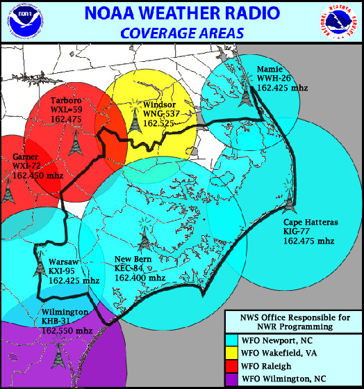
One of the most immediate and reliable ways to receive forecasts, watches, and warnings for the waterways of eastern North Carolina is through NOAA Weather Radio. The following table and map outline the best transmitter for area waterways:
| AREA | TRANSMMITTER LOCATION | TRANSMITTER FREQUENCY |
| Coastal Waters off the northern Outer Banks north of Oregon Inlet. Croatan, Roanoke, and eastern Albemarle Sounds and their immediate tributaries. | Mamie, NC (WWH-26) | 162.425 mhz |
| The coastal waters from Oregon Inlet to Ocracoke Inlet. The Pamlico Sound. |
Cape Hatteras, NC (KIG-77) |
162.475 mhz |
| Coastal Waters from Ocracoke Inlet to Surf City. Pamlico and Neuse Rivers and their immediate tributaries. | New Bern, NC (KEC-84) | 162.400 mhz |
Routine forecasts and warnings for mariners in eastern North Carolina waters can be found online at weather.gov/mhx/marine.
Alternatively, to get the forecast for a specific point, visit weather.gov/marine/point and click on the map or enter you lat/lon.
Recorded area marine forecasts can be accessed by calling 252-223-5737 ext. 4.
CONTACT
Please submit any questions or comments to:
Erik Heden
Warning Coordination Meteorologist
National Weather Service
Newport/MoreheadCity
533 Roberts Road
Newport, NC 28570
252-223-5737
erik.heden@noaa.gov


 Map View
 Weather Hazard Briefing (when applicable)
 Forecaster Discussion
 Marine
 Text Products
.png) Skywarn
Skywarn Submit Storm Reports
 Coastal Flood
.png) Surf Forecast/Rip Currents
Surf Forecast/Rip Currents