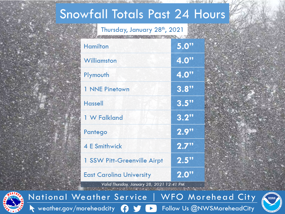
Sample of snow totals for January 28th, 2021.
An area of low pressure moved to our south late in the afternoon of January 27th into the evening of January 28th bringing widespread rain and low clouds to all of Eastern North Carolina. As this area of low pressure moved off the coast, colder air moved into the area. Enough cold air moved in that rain changed to all snow over all over Eastern North Carolina. Where the transition occurred fastest, 1 to as much as 5 inches of snow fell in places such as Greenville, Williamston and Plymouth. Toward the coast flakes were reported as a trace of snow in locations such as New Bern, Jacksonville, Morehead City, Ocracoke and Buxton.
As the low pressure strengthened off the coast during the day of the 28th, strong winds occurred especially along the coast. These strong winds did produce some coastal flooding across Hatteras Island along with scattered power outages for part of our area.
Using the tabs below scroll through for more information and graphics.
Snow Reports
The image below shows that all of Eastern North Carolina reported snow. For most along the immediate coast it was just in the air. Farther north and west accumulations of 1 to 2 inches were common, with more than 3 inches locally.
24 Hour Snowfall Reports
.png)
24 Hour Snowfall Reports (1/28/20)
000 NOUS42 KMHX 281849 CCA PNSMHX NCZ029-044>047-079>081-090>092-094-193>196-198-199-203>205-290508- PUBLIC INFORMATION STATEMENT NATIONAL WEATHER SERVICE NEWPORT/MOREHEAD CITY NC 1208 PM EST THU JAN 28 2021 ...SNOWFALL REPORTS PAST 24 HOURS... LOCATION AMOUNT TIME/DATE PROVIDER ...NORTH CAROLINA... ...BEAUFORT COUNTY... 1 NNE PINETOWN 3.8 IN 0625 AM 01/28 TRAINED SPOTTER PANTEGO 2.9 IN 0807 AM 01/28 PUBLIC 1 SW WASHINGTON 2.0 IN 0641 AM 01/28 PUBLIC BATH 1.5 IN 0722 AM 01/28 PUBLIC BATH 6.6 ESE 1.2 IN 0852 AM 01/28 COCORAHS 1 ESE RIVER ROAD 1.0 IN 1042 AM 01/28 TRAINED SPOTTER AURORA TRACE 0930 AM 01/28 TRAINED SPOTTER CHOCOWINITY TRACE 0900 AM 01/28 TRAINED SPOTTER ...CARTERET COUNTY... BEAUFORT TRACE 0900 AM 01/28 PUBLIC CAPE CARTERET TRACE 0900 AM 01/28 NWS EMPLOYEE 3 S MERRIMON TRACE 0900 AM 01/28 TRAINED SPOTTER MOREHEAD CITY TRACE 0900 AM 01/28 PUBLIC NEWPORT TRACE 0900 AM 01/28 NWS EMPLOYEE OTWAY TRACE 0900 AM 01/28 TRAINED SPOTTER ...CRAVEN COUNTY... 1 NNE CAYTON 0.5 IN 0821 AM 01/28 EMERGENCY MNGR NEW BERN TRACE 0900 AM 01/28 TRAINED SPOTTER RIVER BEND TRACE 0900 AM 01/28 TRAINED SPOTTER TRENT WOODS TRACE 0900 AM 01/28 TRAINED SPOTTER ...DARE COUNTY... 1 N SOUTHERN SHORES 0.7 IN 0904 AM 01/28 TRAINED SPOTTER MANNS HARBOR 0.5 IN 0957 AM 01/28 TRAINED SPOTTER 1 NNW KITTY HAWK 0.5 IN 0715 AM 01/28 PUBLIC DUCK 0.4 IN 1030 AM 01/28 TRAINED SPOTTER 1 ENE COLINGTON 0.1 IN 1000 AM 01/28 TRAINED SPOTTER BUXTON TRACE 0900 AM 01/28 TRAINED SPOTTER NAGS HEAD TRACE 0900 AM 01/28 TRAINED SPOTTER WANCHESE TRACE 0900 AM 01/28 TRAINED SPOTTER ...GREENE COUNTY... 3 NNE ORMONDSVILLE 1.3 IN 0843 AM 01/28 TRAINED SPOTTER ...HYDE COUNTY... 1 ENE SLADESVILLE 0.8 IN 0720 AM 01/28 PUBLIC ENGELHARD 0.8 NW 0.5 IN 0700 AM 01/28 COCORAHS OCRACOKE TRACE 0900 AM 01/28 PUBLIC ...LENOIR COUNTY... LA GRANGE 1.0 IN 0700 AM 01/28 PUBLIC KINSTON 4.4 WNW 0.8 IN 0700 AM 01/28 COCORAHS KINSTON 5.1 WNW 0.5 IN 0700 AM 01/28 COCORAHS 3 NW GRIFTON 0.3 IN 0753 AM 01/28 TRAINED SPOTTER 1 NNW DEEP RUN 0.3 IN 0700 AM 01/28 PUBLIC 2 N KINSTON TRACE 0900 AM 01/28 TRAINED SPOTTER ...MARTIN COUNTY... HAMILTON 5.0 IN 0841 AM 01/28 PUBLIC WILLIAMSTON 4.0 IN 0955 AM 01/28 TRAINED SPOTTER HASSELL 3.5 IN 0844 AM 01/28 PUBLIC 4 E SMITHWICK 2.7 IN 0500 AM 01/28 PUBLIC ...ONSLOW COUNTY... 5 SSW JACKSONVILLE TRACE 0900 AM 01/28 TRAINED SPOTTER ...PAMLICO COUNTY... LOWLAND 0.2 SE 0.4 IN 0700 AM 01/28 COCORAHS ARAPAHOE TRACE 0930 AM 01/28 TRAINED SPOTTER MERRITT TRACE 0900 AM 01/28 TRAINED SPOTTER ...PITT COUNTY... 1 W FALKLAND 3.2 IN 0840 AM 01/28 TRAINED SPOTTER 1 SSW PITT-GREENVILLE AIRPOR 2.5 IN 1003 AM 01/28 PUBLIC 2 SSW GREENVILLE 2.0 IN 0847 AM 01/28 TRAINED SPOTTER EAST CAROLINA UNIVERSITY 2.0 IN 0755 AM 01/28 TRAINED SPOTTER FOUNTAIN 0.1 NE 2.0 IN 0700 AM 01/28 COCORAHS 2 SSW FOUNTAIN 2.0 IN 0630 AM 01/28 TRAINED SPOTTER FARMVILLE 3.1 NW 1.8 IN 0800 AM 01/28 COCORAHS GREENVILLE 5.0 SE 1.7 IN 0800 AM 01/28 COCORAHS 4 ESE WINTERVILLE 1.5 IN 1002 AM 01/28 TRAINED SPOTTER GRIMESLAND 4.7 W 1.5 IN 0800 AM 01/28 COCORAHS GREENVILLE 2.0 SE 1.5 IN 0800 AM 01/28 COCORAHS WINTERVILLE 3.5 W 1.5 IN 0700 AM 01/28 COCORAHS WINTERVILLE 2.8 WNW 1.5 IN 0700 AM 01/28 COCORAHS WINTERVILLE 1.0 ENE 1.5 IN 0700 AM 01/28 COCORAHS 3 S DOWDY FICKLEN STADIUM 1.5 IN 0615 AM 01/28 PUBLIC WINTERVILLE 2.6 ENE 1.3 IN 0900 AM 01/28 COCORAHS GREENVILLE 2.8 ESE 1.2 IN 0900 AM 01/28 COCORAHS 1 W WINTERVILLE 1.2 IN 0930 AM 01/28 TRAINED SPOTTER ...TYRRELL COUNTY... GUM NECK (COOP) 0.5 IN 0600 AM 01/28 COOP ...WASHINGTON COUNTY... PLYMOUTH 4.0 IN 0838 AM 01/28 PUBLIC && |
Pictures
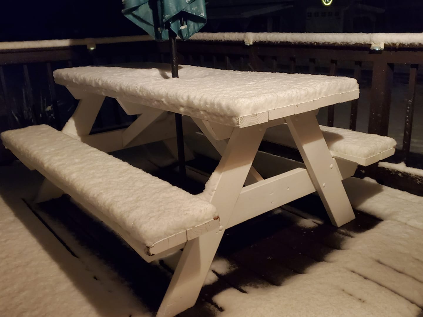
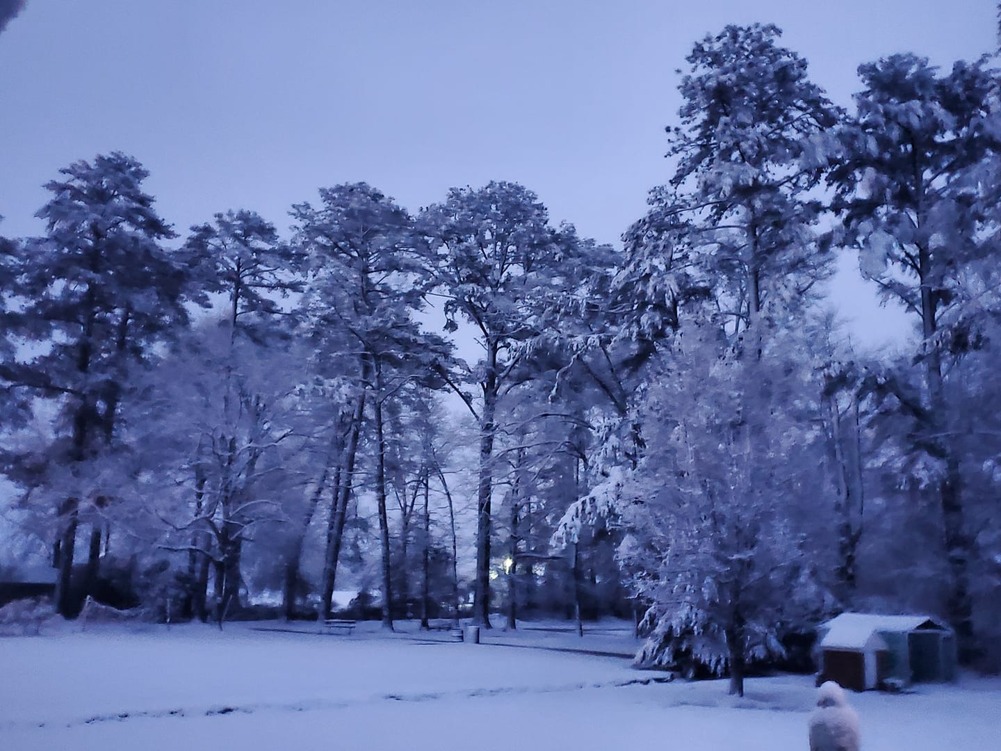
With the snowfall occuring in the early morning hours of the 28th, we got some fantastic photos as the sun came up. Take a look below at some photos that people have shared with us. If you have photos to share, please email Erik at erik.heden@noaa.gov.
|
Farm Life, NC
Credit: Megan Williams Simpson |
Farm Life, NC
Credit: Megan Williams Simpson |
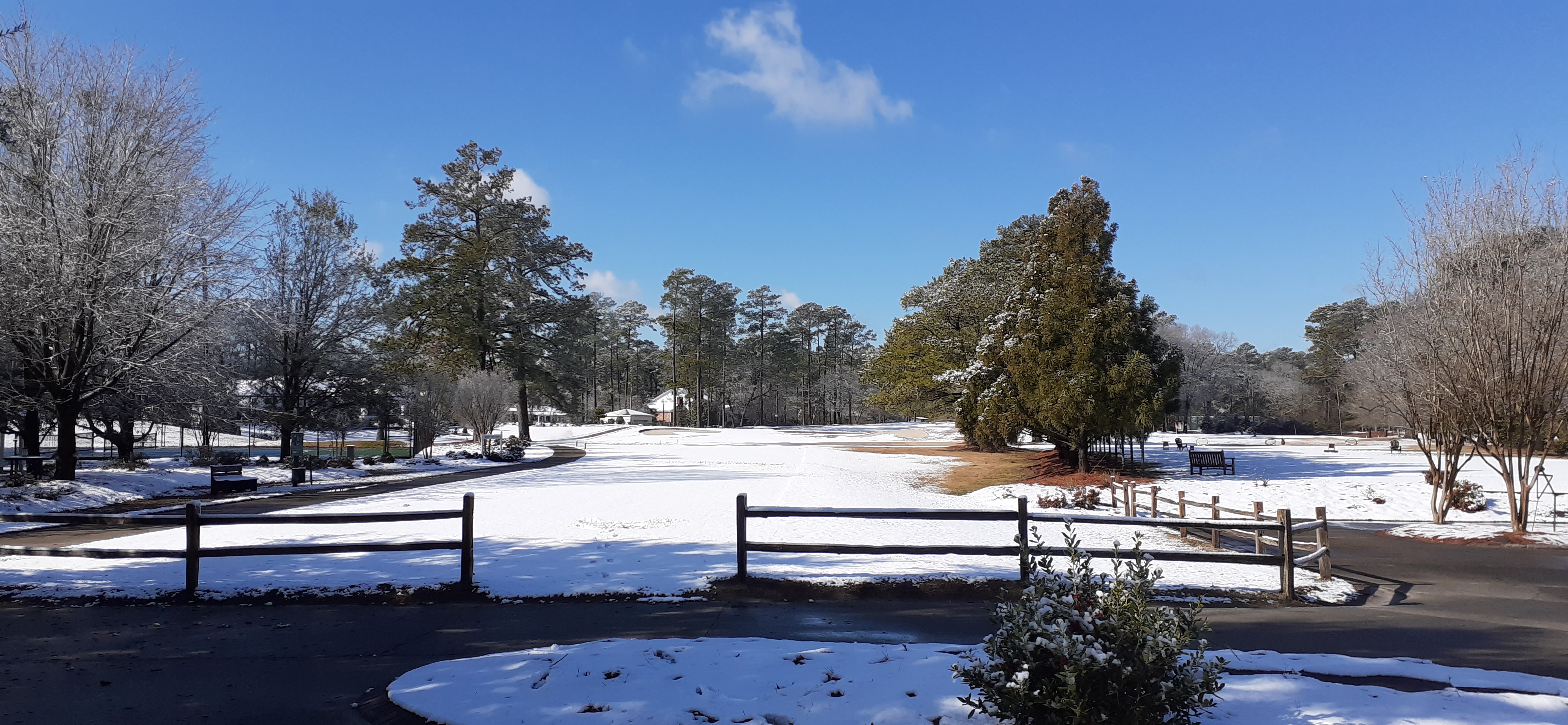
Washington, NC
Credit: Peg Bodie |
Videos
While snow is not rare in Eastern North Carolina, it certainly is northworthy enough for people to take a lot of pictures AND video. Check out the video we put together outside our office prior to daybreak on the 28th.
National Weather Service Office (Newport, NC)
Greenville, NC
Greenville, NC
Wind Reports/Coastal Flooding
The area of low pressure that caused the snow in our area also produced some gusty winds, especially near the coast. While everybody experienced breezy conditions, strong tropical storm force winds were common over the Outer Banks. With strong northly winds, water level rises occurred on the southeastern end of Pamlico Sound over Hatteras Island. Water covered portions of Highway 12 for a time, with up to 2 feet of inundation (above normally dry ground) reported. While the water was high at one end of Pamlico Sound, at the other end or the western end of Pamlico Sound low water was present due to the strong winds "blowing" out the water. Scroll below to see wind reports and coastal flooding images.
A Sample Of Some Wind Gusts January 28th, 2021
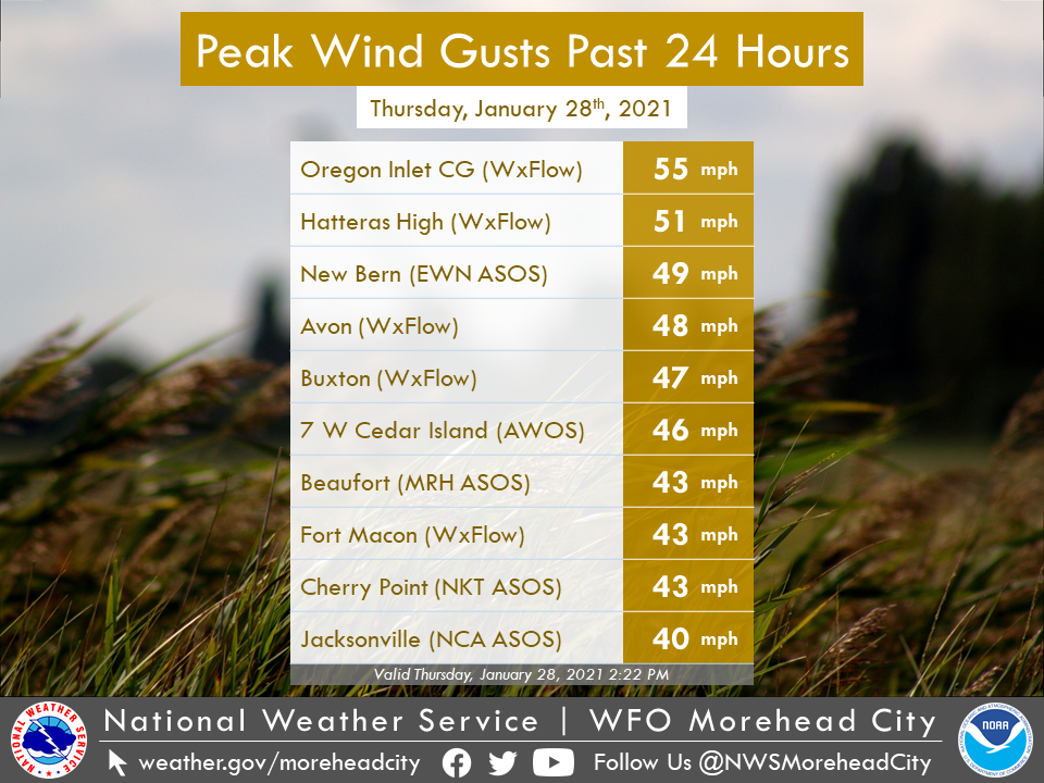
Maximum Wind Reports (1/28/21)
000 NOUS42 KMHX 281901 PNSMHX NCZ029-044>047-079>081-090>092-094-193>196-198-199-203>205-290701- PUBLIC INFORMATION STATEMENT NATIONAL WEATHER SERVICE NEWPORT/MOREHEAD CITY NC 201 PM EST THU JAN 28 2021 ...HIGHEST WIND REPORTS... LOCATION SPEED TIME/DATE PROVIDER ...NORTH CAROLINA... ...BEAUFORT COUNTY... BUNYAN RAWS 32 MPH 0113 PM 01/28 RAWS ...CARTERET COUNTY... 7 W CEDAR ISLAND 46 MPH 0856 AM 01/28 AWOS EMERALD ISLE 44 MPH 0621 AM 01/28 CWOP BEAUFORT (MRH ASOS) 43 MPH 1258 PM 01/28 ASOS BOGUE FIELD (NJM ASOS) 43 MPH 1157 AM 01/28 AWOS FORT MACON (WXFLOW) 43 MPH 0458 AM 01/28 WXFLOW CAPE LOOKOUT 41 MPH 0700 AM 01/28 NDBC CROATAN RAWS 40 MPH 0105 PM 01/28 RAWS NEWPORT 35 MPH 0110 PM 01/28 CWOP MOREHEAD CITY 34 MPH 0145 PM 01/28 CWOP INDIAN BEACH 30 MPH 0147 PM 01/28 CWOP ATLANTIC BEACH 30 MPH 0231 AM 01/28 CWOP ...CRAVEN COUNTY... NEW BERN (EWN ASOS) 49 MPH 1254 PM 01/28 ASOS CHERRY POINT (NKT ASOS) 43 MPH 1254 PM 01/28 AWOS HAVELOCK 39 MPH 1131 AM 01/28 CWOP TRENT WOODS 32 MPH 1147 AM 01/28 CWOP NEW BERN RAWS 32 MPH 1117 AM 01/28 RAWS ...DARE COUNTY... OREGON INLET CG (WXFLOW) 55 MPH 1032 AM 01/28 WXFLOW HATTERAS HIGH (WXFLOW) 51 MPH 0912 AM 01/28 WXFLOW KHK RESORT (WXFLOW) 51 MPH 0759 AM 01/28 WXFLOW REAL SLICK (WXFLOW) 49 MPH 0806 AM 01/28 WXFLOW RODANTHE 48 MPH 0123 PM 01/28 CWOP AVON (WXFLOW) 48 MPH 0804 AM 01/28 WXFLOW KILL DEVIL HILLS 47 MPH 0935 AM 01/28 CWOP BUXTON (WXFLOW) 47 MPH 0824 AM 01/28 WXFLOW FRISCO 47 MPH 0802 AM 01/28 CWOP NAGS HEAD 43 MPH 0941 AM 01/28 CWOP FRISCO (HSE ASOS) 40 MPH 0851 AM 01/28 ASOS MANTEO (MQI AWOS) 37 MPH 0855 AM 01/28 AWOS DARE CO GNRY RAN (2DP AWOS) 35 MPH 1056 AM 01/28 AWOS DARE BOMB RANGE RAWS 34 MPH 0728 AM 01/28 RAWS ...DUPLIN COUNTY... SUMMERLINS CROSSROADS 3 SE 31 MPH 0800 AM 01/28 COOP ...HYDE COUNTY... 4 NE ENGELHARD 37 MPH 0915 AM 01/28 AWOS FAIRFIELD RAWS 30 MPH 0717 AM 01/28 RAWS ...ONSLOW COUNTY... JACKSONVILLE (NCA ASOS) 40 MPH 1256 PM 01/28 AWOS SNEADS FERRY 39 MPH 1215 PM 01/28 CWOP SANDY RUN RAWS 34 MPH 1119 AM 01/28 RAWS RICHLANDS (OAJ AWOS) 33 MPH 1256 PM 01/28 AWOS JACKSONVILLE 33 MPH 1212 PM 01/28 CWOP ...PAMLICO COUNTY... ORIENTAL 39 MPH 0117 PM 01/28 CWOP ...WASHINGTON COUNTY... ROPER 33 MPH 1231 AM 01/28 CWOP TIDEWATER RESEARCH STATION 30 MPH 1230 PM 01/28 NC-ECONET ...MARITIME STATIONS... 18 SE CAPE HATTERAS LIGHTHOU 63 MPH 0840 AM 01/28 NDBC JENNETTES PIER (WXFLOW) 55 MPH 1014 AM 01/28 WXFLOW 31 S BOGUE INLET PIER 54 MPH 0608 AM 01/28 NDBC OCRACOKE (WXFLOW) 53 MPH 0739 AM 01/28 WXFLOW AVON SOUND (WXFLOW) 51 MPH 0935 AM 01/28 WXFLOW FRISCO WOODS (WXFLOW) 50 MPH 0859 AM 01/28 WXFLOW DUCK PIER 49 MPH 0848 AM 01/28 NOS-NWLON ALLIGATOR RIVER BR (WXFLOW) 49 MPH 0639 AM 01/28 WXFLOW PAMLICO SOUND (WXFLOW) 49 MPH 1008 AM 01/28 WXFLOW ROANOKE SOUND CHANNEL (WXFLO 43 MPH 0812 AM 01/28 WXFLOW NORTH RIVER 42 MPH 0107 PM 01/28 WXFLOW CROATAN SOUND 40 MPH 1257 PM 01/28 WXFLOW BEAUFORT 38 MPH 0900 AM 01/28 NOS-NWLON SOUTHERN SHORES 37 MPH 0910 AM 01/28 CWOP && Observations are collected from a variety of sources with varying equipment and exposures. We thank all volunteer weather observers for their dedication. Not all data listed are considered official. |
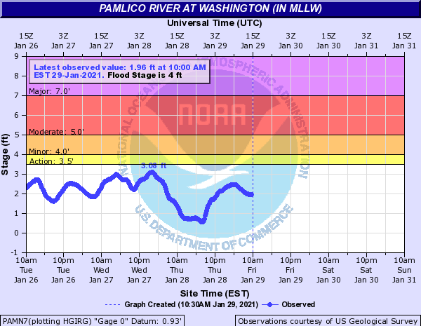
With the two images below you an see the impacts of water levels in our area due to persistent strong winds. In this case we had strong northerly winds which caused water level rises on the southern end of Pamlico Sound, including Hatteras Island where high water was reported on Highway 12. At the opposite end of the sound these strong winds caused low water near Washington, NC (see second graph).
Pamlico Sound At Coast Guard Hatteras
Water Level Gauge

Water Level Gauge
Radar
On the loop below, rain is found across all of Eastern North Carolina at the start of the loop on the evening of January 27th. Gradually as colder air works into our area, the rain changes completely over to snow.
KMHX Doppler Radar Loop (Showing Rain Changing To Snow)
Early morning January 28th, 2021
Satellite
As the snow ended we saw a brief window of clear skies and sunshine. This allowed us to view the snow cover from outer space with our GOES-16 Satellite. On the image below, the area circled in yellow, is snow cover. You may be able to distinguish the difference between clouds (also white) and snow cover (white) by viewing the video versus the still image.
GOES 16 Satellite Loop (Showing Snow Cover) January 28th, 2021
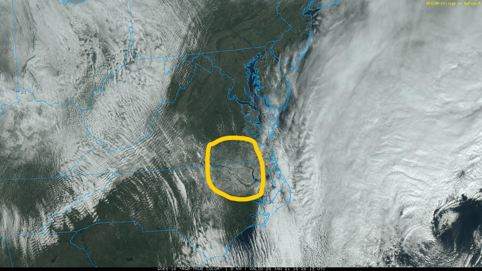
GOES 16 Satellite Imagery Showing Snow Cover on January 28th, 2021.


 Map View
 Weather Hazard Briefing (when applicable)
 Forecaster Discussion
 Marine
 Text Products
.png) Skywarn
Skywarn Submit Storm Reports
 Coastal Flood
.png) Surf Forecast/Rip Currents
Surf Forecast/Rip Currents