
National Weather Service Office, Newport, NC. January 29th, 2022.
Widespread light snow fell across Eastern North Carolina early on the morning of January 29th, 2022. The accumulation of snow was primarily confined to grassy surfaces, car tops, decks, and roofs with surface temperatures mainly above freezing as the snow fell. In addition once the snow stopped Saturday morning, it quickly melted in areas that saw any accumulation. A cold front moved through the area the previous night, allowing temperatures to fall overnight changing some of the rain to snow. A stronger storm developed well to our east over the ocean during this time and eventually went on to produce a blizzard across coastal sections of the Northeast. While we saw some moisture from this system, the bulk of the snowfall Saturday morning fell as a weak disturbance passed through the area. On the backside of the larger storm over the ocean, MUCH colder air filtered in Saturday, setting the stage for a very cold night Saturday night into Sunday morning. Scroll down through images and videos of the snowfall and cold weather in our area.
Map Of Snowfall January 29th, 2022
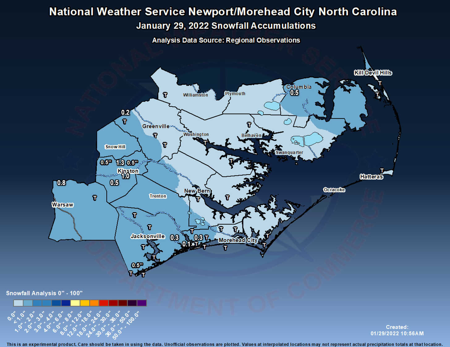
Snow Reports Text List
Public Information Statement National Weather Service Newport/Morehead City NC 1009 AM EST Sat Jan 29 2022 ...SNOWFALL REPORTS... Location Amount Time/Date Provider ...North Carolina... ...Beaufort County... 1 WNW Aurora T in 0812 AM 01/29 Public Pantego T in 0404 AM 01/29 Trained Spotter 1 NW River Road T in 0641 AM 01/29 Public ...Carteret County... 1 WNW Bogue 0.3 in 0846 AM 01/29 NWS Employee 2 W Newport 0.2 in 0822 AM 01/29 NWS Employee 1 W Broad Creek T in 0735 AM 01/29 NWS Employee Marshallberg T in 0748 AM 01/29 Public 1 W Bogue Inlet Pier T in 0801 AM 01/29 Public 2 SSW Wildwood T in 0854 AM 01/29 NWS Employee Pine Knoll Shores T in 0930 AM 01/29 Public 2 WNW Crab Point Village T in 0955 AM 01/29 Public 1 SW Newport T in 0608 AM 01/29 NWS Employee 1 ESE Bogue T in 0637 AM 01/29 Public 2 NNW Peletier T in 0643 AM 01/29 Public 1 ENE Mitchell Village T in 0710 AM 01/29 Public Harkers Island T in 0728 AM 01/29 Public Beaufort T in 0729 AM 01/29 Public ...Craven County... 1 SW Bridgeton 0.1 in 0918 AM 01/29 Public 2 SSW Havelock 0.1 in 0924 AM 01/29 Public 1 SW Coastal Carolina Region T in 0908 AM 01/29 ASOS ...Dare County... Duck 0.3 in 0922 AM 01/29 Newspaper Manns Harbor 0.3 in 0949 AM 01/29 Trained Spotter Whalebone 0.1 in 0727 AM 01/29 Public Hatteras Island Fishing Pier T in 0742 AM 01/29 Public Frisco T in 0838 AM 01/29 Public 1 WNW Nags Head Fishing Pier T in 0900 AM 01/29 Trained Spotter 1 SSE Manteo T in 0937 AM 01/29 Broadcast Media ...Duplin County... Wallace 0.4 in 0948 AM 01/29 Trained Spotter 1 WNW Albertson 0.3 in 0924 AM 01/29 Public 3 N Sarecta T in 0647 AM 01/29 Public ...Hyde County... Ocracoke Village T in 0741 AM 01/29 Public ...Jones County... Maysville 0.3 in 0812 AM 01/29 Public ...Lenoir County... 1 N Kinston 0.5 in 0751 AM 01/29 Trained Spotter 1 SW La Grange 0.5 in 0825 AM 01/29 Trained Spotter 1 SE Kinston 0.3 in 0730 AM 01/29 Public ...Martin County... Williamston 0.1 in 0804 AM 01/29 Broadcast Media 3 E Smithwick 0.1 in 0810 AM 01/29 Public Parmele T in 0844 AM 01/29 Public ...Onslow County... 3 NNE Haws Run 0.5 in 0942 AM 01/29 Trained Spotter Holly Ridge 0.5 in 1002 AM 01/29 Public 2 NNW New River Station 0.4 in 0829 AM 01/29 Public 2 E Haws Run 0.3 in 0717 AM 01/29 Public 2 NW Jacksonville 0.2 in 0741 AM 01/29 Public Swansboro 0.1 in 0812 AM 01/29 Public 2 WSW Sea View Pier 0.1 in 0917 AM 01/29 Public 2 ESE Hubert 0.1 in 0925 AM 01/29 Public 1 W Sneads Ferry T in 0811 AM 01/29 Public Holly Ridge T in 0813 AM 01/29 Public 2 NW Jacksonville T in 0642 AM 01/29 Public 1 S Richlands T in 0644 AM 01/29 Public 2 N Verona T in 0645 AM 01/29 Public 1 NW North Topsail Beach T in 0713 AM 01/29 Public ...Pamlico County... 1 SSW Whortonsville 0.1 in 0811 AM 01/29 Public Bayboro 0.1 in 0842 AM 01/29 Public Arapahoe T in 0930 AM 01/29 Public ...Pitt County... 1 W Winterville 0.1 in 0802 AM 01/29 Broadcast Media 2 NW Farmville T in 0644 AM 01/29 Public 2 SSW Dowdy Ficklen Stadium T in 0720 AM 01/29 Public 4 WNW Shelmerdine T in 0721 AM 01/29 Public ...Tyrrell County... Columbia 0.1 in 0911 AM 01/29 Public && |
With surface temperatures mainly above freezing, the majority of any snow accumulation was on the usual cold spots (grassy surfaces, car tops, roofs, elevated decks, etc). This gave the appearance of a clumpy snow, on anything it stuck to as you can see from the picture below.
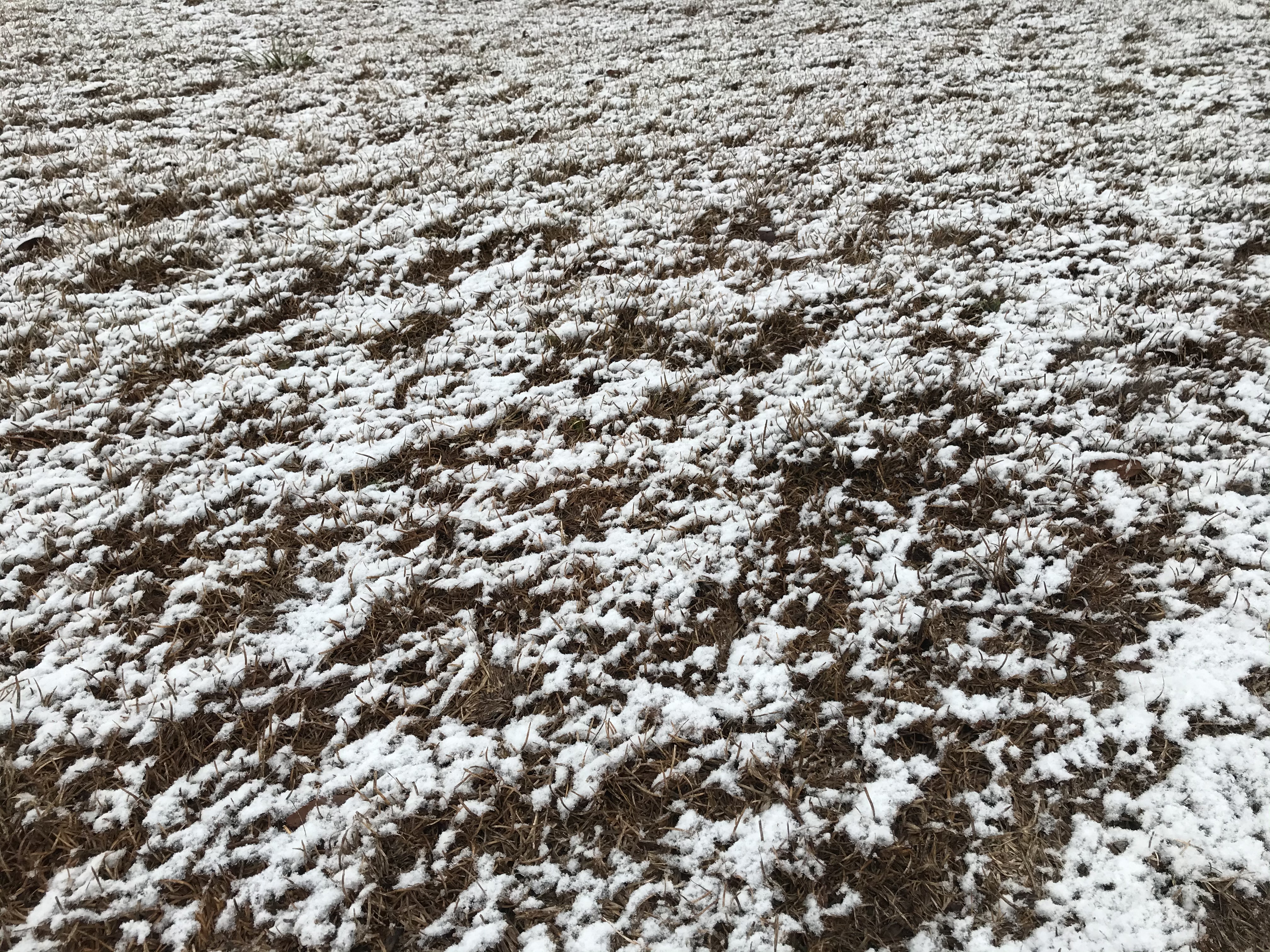
Cape Carteret Saturday January 29th, 2022. Credit: Rebekah H.
Newport, NC
January 29th, 2022
Credit: National Weather Service
Bogue Sound, NC
January 29th, 2022
Credit: John Elardo
While the snow did not last long across our area, what followed was a period of very cold weather. Temperatures Saturday after the snow fell remained in the 30s for most of the area, outside of coastal locations. High pressure settled over the area Saturday night, and that made for some chilly air by Sunday morning. Low temperatures ranged from the mid to upper 20s on the Outer Banks to middle teens inland away from the water.
Sunday Morning Low Temperatures (1/30/22)
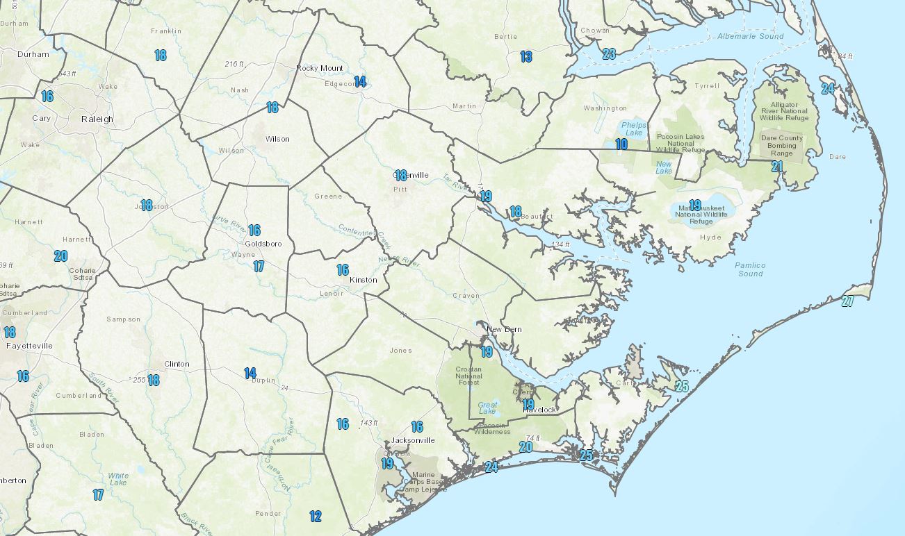
Sunday Morning Low Temperatures (1/30/22)
...LOW TEMPERATURE REPORTS... Location Temp Time/Date Provider ...North Carolina... ...Beaufort County... Bunyan RAWS 18 F 0713 AM 01/30 RAWS Belhaven 1.8 SW 19 F 0718 AM 01/30 CWOP Washington (OCW AWOS) 19 F 0735 AM 01/30 AWOS Bunyan RAWS 22 F 0513 AM 01/30 HADS Aurora 5.6 NE (Pamlico Aqua 24 F 0800 AM 01/30 NC-ECONET ...Carteret County... Newport 2.5 W 16 F 0730 AM 01/30 CWOP Newport 0.2 SW 18 F 0731 AM 01/30 CWOP Newport 10.3 ENE 18 F 0716 AM 01/30 CWOP Newport 6.3 SW 19 F 0745 AM 01/30 CWOP Newport 6.4 SW 19 F 0646 AM 01/30 CWOP Cape Carteret 0.6 E 21 F 0731 AM 01/30 CWOP Morehead City 4.7 W 21 F 0630 AM 01/30 CWOP Croatan RAWS 21 F 0548 AM 01/30 RAWS Newport 7.5 E 22 F 0735 AM 01/30 CWOP Davis 23 F 0710 AM 01/30 DAVIS Indian Beach 0.3 WSW 23 F 0716 AM 01/30 CWOP Atlantic Beach 0.4 E 23 F 0715 AM 01/30 CWOP Bogue Field (NJM ASOS) 23 F 1157 PM 01/30 AWOS Emerald Isle 24 F 0715 AM 01/30 DAVIS Emerald Isle 24 F 0750 AM 01/30 DAVIS Beaufort 0.3 SE 25 F 0740 AM 01/30 AWS Emerald Isle 25 F 0735 AM 01/30 DAVIS Harkers Island 25 F 0645 AM 01/30 DAVIS Emerald Isle 3 WSW 25 F 0735 AM 01/30 CWOP Beaufort 25 F 0755 AM 01/30 CWOP Beaufort (MRH ASOS) 25 F 1158 PM 01/30 ASOS Cedar Island RAWS 25 F 0625 AM 01/30 HADS Fort Macon (WxFlow) 25 F 0745 AM 01/30 WXFLOW Beaufort 26 F 0811 AM 01/30 CWOP Beaufort (Duke Marine Lab) 26 F 0754 AM 01/30 NOS-NWLON Piney Island (NBT AWOS) 26 F 1256 PM 01/30 AWOS Cape Lookout 27 F 0700 AM 01/30 NDBC ...Craven County... James City 5.3 SW 15 F 0746 AM 01/30 CWOP Cherry Point (NKT ASOS) 17 F 0656 AM 01/30 AWOS New Bern RAWS 17 F 0717 AM 01/30 RAWS Havelock 3 S 18 F 0715 AM 01/30 AWS James City 3 S 19 F 0715 AM 01/30 AWS Havelock 0.7 NW 19 F 0735 AM 01/30 CWOP New Bern (EWN ASOS) 19 F 1154 PM 01/30 ASOS ...Dare County... Dbr Soil Monitor 17 F 0754 AM 01/30 RAWS Dare Co Gnry Ran (2DP AWOS) 19 F 1156 PM 01/30 AWOS Southern Shores 1.7 NNW 22 F 0718 AM 01/30 CWOP Nags Head 1.3 NW 23 F 0730 AM 01/30 AWS Kill Devil Hills 23 F 0720 AM 01/30 DAVIS Nags Head 23 F 0717 AM 01/30 CWOP Dare Bomb Range RAWS 23 F 0628 AM 01/31 RAWS Oregon Inlet (WxFlow) 23 F 0706 AM 01/30 WXFLOW Manteo 24 F 0725 AM 01/30 DAVIS Manteo (MQI AWOS) 24 F 0715 AM 01/30 AWOS Oregon Inlet Marina 24 F 0748 AM 01/30 NOS-NWLON Manteo 25 F 0710 AM 01/30 DAVIS Buxton 0.7 SE 26 F 0800 AM 01/30 CWOP Buxton 26 F 0630 AM 01/30 RAWS Oregon Inlet CG (WxFlow) 26 F 0803 AM 01/30 WXFLOW Rodanthe 0.6 N 27 F 0540 AM 01/30 CWOP Frisco 0.3 SW 27 F 0731 AM 01/30 CWOP Frisco (HSE ASOS) 27 F 1251 PM 01/30 ASOS Avon (WxFlow) 27 F 0737 AM 01/30 WXFLOW Buxton (WxFlow) 27 F 0727 AM 01/30 WXFLOW Hatteras High (WxFlow) 27 F 0724 AM 01/30 WXFLOW Real Slick (WxFlow) 27 F 0934 AM 01/30 WXFLOW ...Duplin County... Kenansville (DPL AWOS) 14 F 0735 AM 01/30 AWOS Wallace 6.4 WNW (Williamsdal 14 F 0725 AM 01/30 NC-ECONET Jacksonville 8.8 NNW 17 F 0717 AM 01/30 CWOP ...Hyde County... Engelhard (7W6 AWOS) 19 F 0715 AM 01/30 AWOS Fairfield RAWS 19 F 0717 AM 01/30 RAWS Swan Quarter Ferry Terminal 22 F 0300 PM 01/31 COOP Ocracoke 27 F 0320 AM 01/30 DAVIS ...Lenoir County... Kinston (ISO AWOS) 16 F 0656 AM 01/30 AWOS Seven Springs 3.2 SE 19 F 0800 AM 01/30 CWOP Kinston 2.5 NNE (Cunningham 20 F 0735 AM 01/30 NC-ECONET ...Martin County... Williamston 2.4 WSW (HP Comm 16 F 0700 AM 01/30 NC-ECONET Williamston 1 ENE (COOP) 25 F 0800 AM 01/31 COOP ...Onslow County... Jacksonville 1.7 NNW 14 F 0737 AM 01/30 CWOP Jacksonville 7.0 W 15 F 0741 AM 01/30 CWOP Hoffman RAWS 16 F 0710 AM 01/30 RAWS Richlands (OAJ AWOS) 16 F 1156 PM 01/30 AWOS Sandy Run RAWS 17 F 0719 AM 01/30 RAWS Holly Ridge 4.8 E 17 F 0730 AM 01/30 CWOP Jacksonville 18 F 0750 AM 01/30 DAVIS Jacksonville (NCA ASOS) 19 F 1256 PM 01/30 AWOS Sneads Ferry 1.7 SE 22 F 0730 AM 01/30 CWOP ...Pamlico County... Bayboro 0.4 W 19 F 0705 AM 01/30 AWS Arapahoe 20 F 0710 AM 01/30 DAVIS Oriental 1.7 NE 20 F 0745 AM 01/30 CWOP Reelsboro 24 F 0500 PM 01/31 COOP ...Pitt County... Winterville 3 WNW 17 F 0824 AM 01/30 CWOP Greenville 3.8 S 17 F 0718 AM 01/30 CWOP Greenville (PGV AWOS) 18 F 0715 AM 01/30 AWOS Greenville (Dowdy Ficklen St 22 F 0750 AM 01/30 MESOWEST ...Washington County... Pocosin Lakes RAWS 10 F 0717 AM 01/30 RAWS Pocosin Lakes RAWS 11 F 0617 AM 01/30 HADS Tidewater Research Station 17 F 0720 AM 01/30 NC-ECONET Creswell 2.6 SSW 18 F 0731 AM 01/30 CWOP 2.0 W Roper (SCAN) 18 F 0700 AM 01/30 MESOWEST Roper 9.8 ENE 25 F 0731 AM 01/30 CWOP ...Maritime Stations... North River 22 F 0713 AM 01/30 WXFLOW Duck Pier 23 F 0736 AM 01/30 NOS-NWLON Alligator River Br (WxFlow) 25 F 0717 AM 01/30 WXFLOW Croatan Sound 25 F 0650 AM 01/30 WXFLOW Jennettes Pier (WxFlow) 25 F 0758 AM 01/30 WXFLOW Roanoke Sound Channel (WxFlo 26 F 0840 AM 01/30 WXFLOW Pamlico Sound (WxFlow) 27 F 0922 AM 01/30 WXFLOW Avon Sound (WxFlow) 28 F 1009 AM 01/30 WXFLOW Ocracoke (WxFlow) 28 F 1017 AM 01/30 WXFLOW && Observations are collected from a variety of sources with varying equipment and exposures. We thank all volunteer weather observers for their dedication. Not all data listed are considered official. $$ && |


 Map View
 Weather Hazard Briefing (when applicable)
 Forecaster Discussion
 Marine
 Text Products
.png) Skywarn
Skywarn Submit Storm Reports
 Coastal Flood
.png) Surf Forecast/Rip Currents
Surf Forecast/Rip Currents