
Highway 58 Maysville, just south of the intersection with Highway 17. Sunday morning around 730 AM (1/16/2022). Credit Erik Heden.
An intensifying area of low pressure moved across central North Carolina, bringing a variety of weather impacts to our area. Two days prior, a cold front moved south of the area on January 14th. Behind the front a large area of high pressure (1034 MB) settled over Upstate New York by Sunday morning, January 14th. Meanwhile a disturbance in the jet stream winds aloft dove south over the central part of the country, and helped spawn an area of low pressure near the panhandle of Florida Saturday night (15th) into Sunday morning (16th). The stage was set with low pressure moving northward, creating a surge of warmer air and precipitation moving toward our area. Meanwhile thanks to our recent cold frontal passage and a strong area of high pressure to our northeast, northeast winds funneled in cold air into our area. Enough cold air remained across our area, especially near the surface, that we saw a wintry mix of sleet and freezing rain for areas near and west of Highway 17 very early Sunday morning.
Eventually the storm system over Florida raced northeast and deepened to 996 MB by Sunday afternoon across north central North Carolina. The track of the low to our west, placed much of Eastern North Carolina into the warm sector. Any wintry mix changed to plain rain by mid morning and by afternoon, temperatures surged into the 60s along the Crystal Coast! Winds veered from the northeast into the southeast to due south and became strong. Winds over 30 MPH were common across the coast for multiple hours. This strong southerly wind caused minor to moderate coastal flooding in portions of Eastern Carteret County and especially up the Pungo River into Belhaven. Rain, heavy at times, continued over much of the area through Sunday afternoon.
As the storm moved north of the area, Sunday evening, a heavier band of rain (with some lightning off the coast) swept through coastal areas. During that time peak gusts occurred with tropical storm force winds common from Carteret County northeast through the Outer Banks. As winds quickly shift from the south into the southwest and eventually southwest, water that had been pushed toward the western part of the Pamlico Sound, sloshed back to the east. This caused minor sound side Flooding along Highway 12 in Hatteras Village and up through Rodanthe. Large waves, greater than 20 feet, caused oceanside inundation across Ocracoke Island and part of Highway 12 near the S Curves. These areas had been impacted by 2 coastal storms already this fall and winter season. When all was done a general 1 to 3" of rain fell over the area.
Scroll through the event using these tabs to learn more.
Coastal Flooding
Coastal flooding impacted portions of Highway 12 on the Outer Banks and was likely helped by this being the third storm of the fall/winter season. With a stronger southeast wind, areas as far north as Belhaven, along the Pungo River, also saw minor to moderate water levels as water was pushed toward the western end of the Pamlico Sound, and up area rivers. Flooding also occurred in Washington, as water was pushed up the Pamlico River as well.
Below are some weather related graphs and information. Please see the videos and pictures tab for more on the impacts.
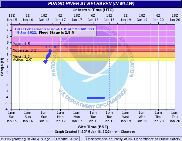
The above gauge at Belhaven shows a peak value of 3.76 Feet (Mean LLW) Sunday afternoon. Flooding was reported along the Pungo and Pamlico Rivers, due to water being pushed back up the rivers, with a strong southeast wind off the Pamlico Sound.
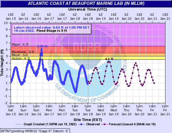
The above gauge at Beaufort shows the peak of the water was high tide Sunday afternoon. While the water was not nearly as high as the previous storm earlier this month and also did not impact multiple tide cycles as much, flooding was still reported in Beaufort. The fact that this storm did -NOT- occur during a period of higher than normal tides, helped us a lot.
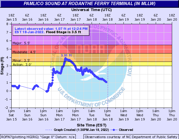
As strong southeast to south winds shifted into the southwest and eventually west, water levels increased quickly along the eastern end of the Pamlico Sound early Monday morning.
PRELIMINARY LOCAL STORM REPORT
NATIONAL WEATHER SERVICE NEWPORT/MOREHEAD CITY NC
643 PM EST MON JAN 17 2022

..TIME...   ...EVENT...      ...CITY LOCATION...     ...LAT.LON...
..DATE...   ....MAG....      ..COUNTY LOCATION..ST.. ...SOURCE....
            ..REMARKS..

0730 PM     COASTAL FLOOD    MIRLO BEACH             35.61N 75.47W
01/16/2022                   DARE               NC   DEPT OF HIGHWAYS

            NC DOT REPORTED MINOR OVERWASH ON HWY 12 IN
            MIRLO BEACH.

0730 PM     COASTAL FLOOD    BUXTON                  35.27N 75.52W
01/16/2022                   DARE               NC   DEPT OF HIGHWAYS

            NC DOT REPORTED MINOR OVERWASH ON HWY 12 IN
            BUXTON.

0730 PM     COASTAL FLOOD    8 ENE OCRACOKE VILLAGE  35.16N 75.85W
01/16/2022                   HYDE               NC   DEPT OF HIGHWAYS

            NC DOT REPORTED MODERATE OCEAN OVERWASH WITH
            SAND ON THE ROADWAY (HWY 12).

0710 PM     NON-TSTM WND DMG ROSE BAY                35.46N 76.42W
01/16/2022                   HYDE               NC   UTILITY COMPANY

            TIDELAND EMC REPORTED TREE ON POWERLINES
            NEAR ROSE BAY.

0630 PM     FLOOD            MOREHEAD CITY           34.72N 76.73W
01/16/2022                   CARTERET           NC   PUBLIC

            PUBLIC REPORTED WATER ON HWY 70 NEAR MUNDEN
            FUNERAL HOME IN MOREHEAD CITY.

0600 PM     COASTAL FLOOD    1 WNW WASHINGTON PARK   35.54N 77.04W
01/16/2022                   BEAUFORT           NC   PUBLIC

            PARKING LOT AT HAVENS GARDENS IS UNDERWATER.
            INUNDATION ESTIMATED AT 3 FT ABOVE GROUND
            LEVEL.

0600 PM     COASTAL FLOOD    1 SSE RIVER ROAD        35.49N 76.99W
01/16/2022                   BEAUFORT           NC   PUBLIC

            YARDS UNDER WATER ON SHADY BANKS BEACH ROAD.
            INUNDATION ESTIMATED AROUND 3 FT ABOVE
            GROUND LEVEL.

0355 PM     COASTAL FLOOD    2 SE WASHINGTON         35.51N 77.03W
01/16/2022                   BEAUFORT           NC   EMERGENCY MNGR

            BEAUFORT COUNTY EMERGENCY MANAGEMENT
            REPORTED INUNDATION OF 2-3 FEET ABOVE GROUND
            AROUND WHICHARDS BEACH AND BROAD CREEK AREA.


0700 AM     COASTAL FLOOD    1 SW HATTERAS ISLAND FI 35.58N 75.47W
01/17/2022                   DARE               NC   PUBLIC

            PUBLIC REPORT OF COASTAL FLOODING IN
            RODANTHE WITH WATER LOCATED OVER THE ROAD ON
            NC-12.

0722 AM     COASTAL FLOOD    1 NNE AVON              35.36N 75.50W
01/17/2022                   DARE               NC   PUBLIC

            PUBLIC REPORT OF COASTAL FLOODING WITH WATER
            RISING UP TO STREET LEVEL.

0740 AM     COASTAL FLOOD    1 NNW SANDERLING        36.23N 75.77W
01/17/2022                   DARE               NC   PUBLIC

            PUBLIC REPORT OF COASTAL FLOODING ALONG
            HIGHWAY 12 WITH WATER ACROSS THE ROAD IN
            DUCK AT CAFFEYS INLET NEIGHBORHOOD.

0740 AM     COASTAL FLOOD    1 N RODANTHE            35.61N 75.47W
01/17/2022                   DARE               NC   DEPT OF HIGHWAYS

            DEEP SOUNDSIDE FLOODING REPORTED ON HIGHWAY
            NC-12 BETWEEN MARC BASNIGHT BRIDGE AND
            HATTERAS.

1000 AM     COASTAL FLOOD    1 S WAVES               35.56N 75.47W
01/17/2022                   DARE               NC   LAW ENFORCEMENT

            SOUND SIDE FLOODING WITH 8 INCHES OF WATER
            COVERING THE ROAD AROUND OTTER WAY IN SALVO
            VIA DARE COUNTY SHERIFFS OFFICE.

0630 PM     COASTAL FLOOD    ROANOKE ISLAND FESTIVAL 35.91N 75.67W
01/17/2022                   DARE               NC   COUNTY OFFICIAL

            MINOR FLOODING IN MANTEO. WATER COVERING
            PORTIONS OF QUEEN ELIZABETH AVENUE AND OTHER
            STREETS IN DOWNTOWN MANTEO.

0630 PM     COASTAL FLOOD    1 NE COLINGTON          36.01N 75.69W
01/17/2022                   DARE               NC   LAW ENFORCEMENT

            MINOR FLOODING ON PORTIONS OF COLINGTON
            ROAD. ROAD CURRENTLY PASSABLE.


&&
|
Ice/Wind Reports
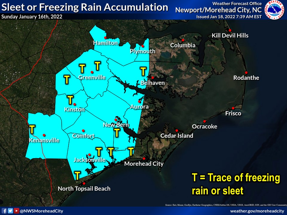
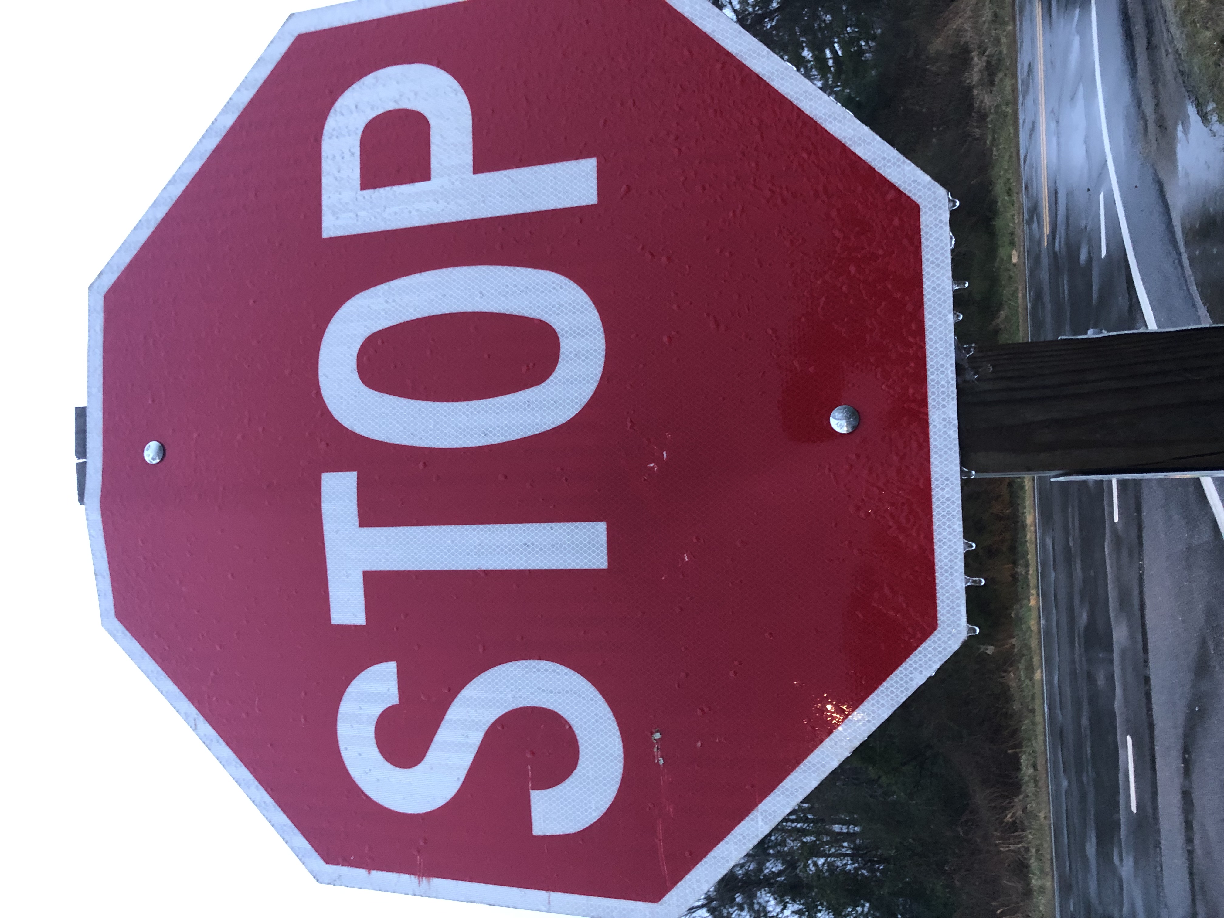
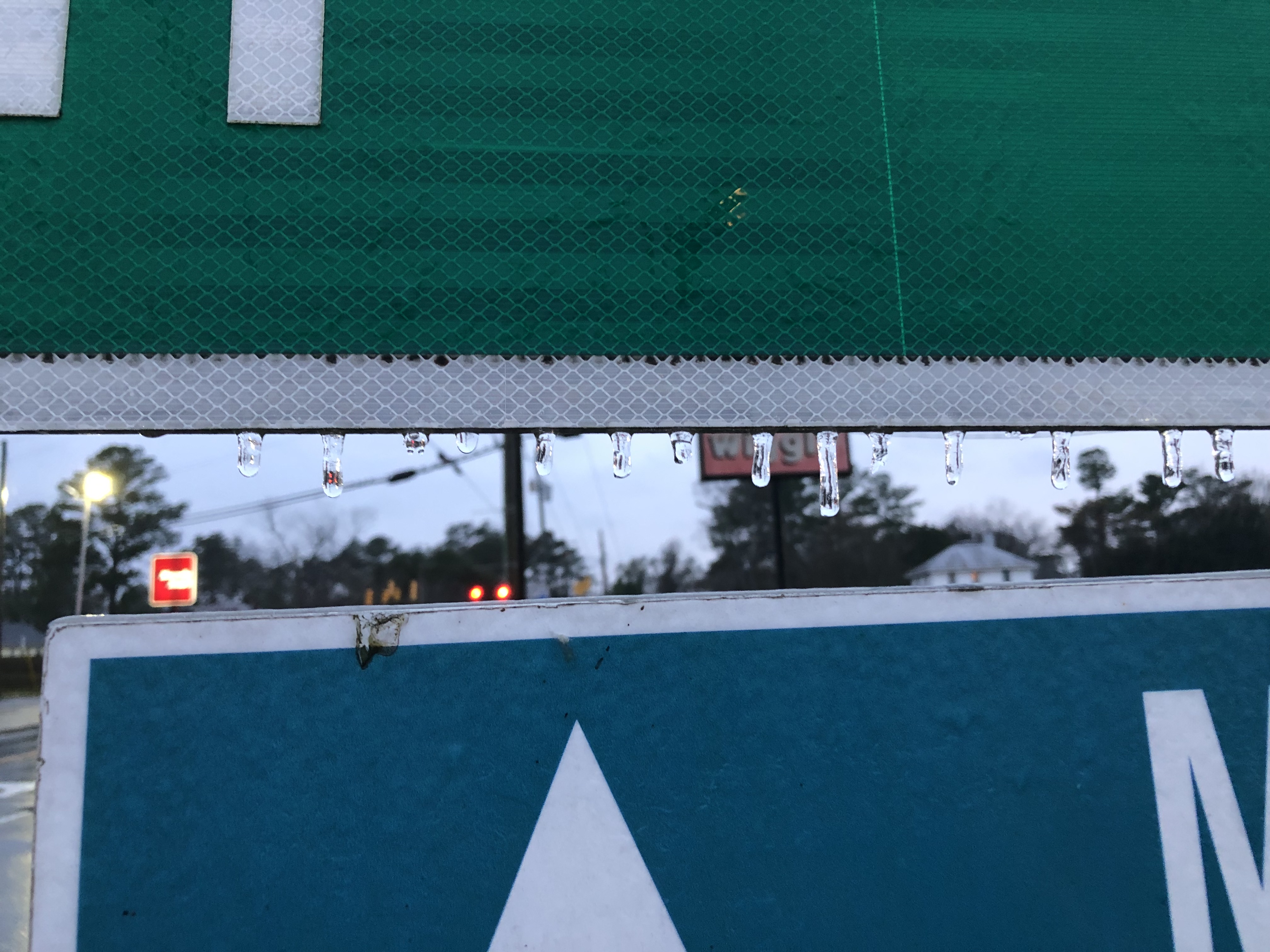
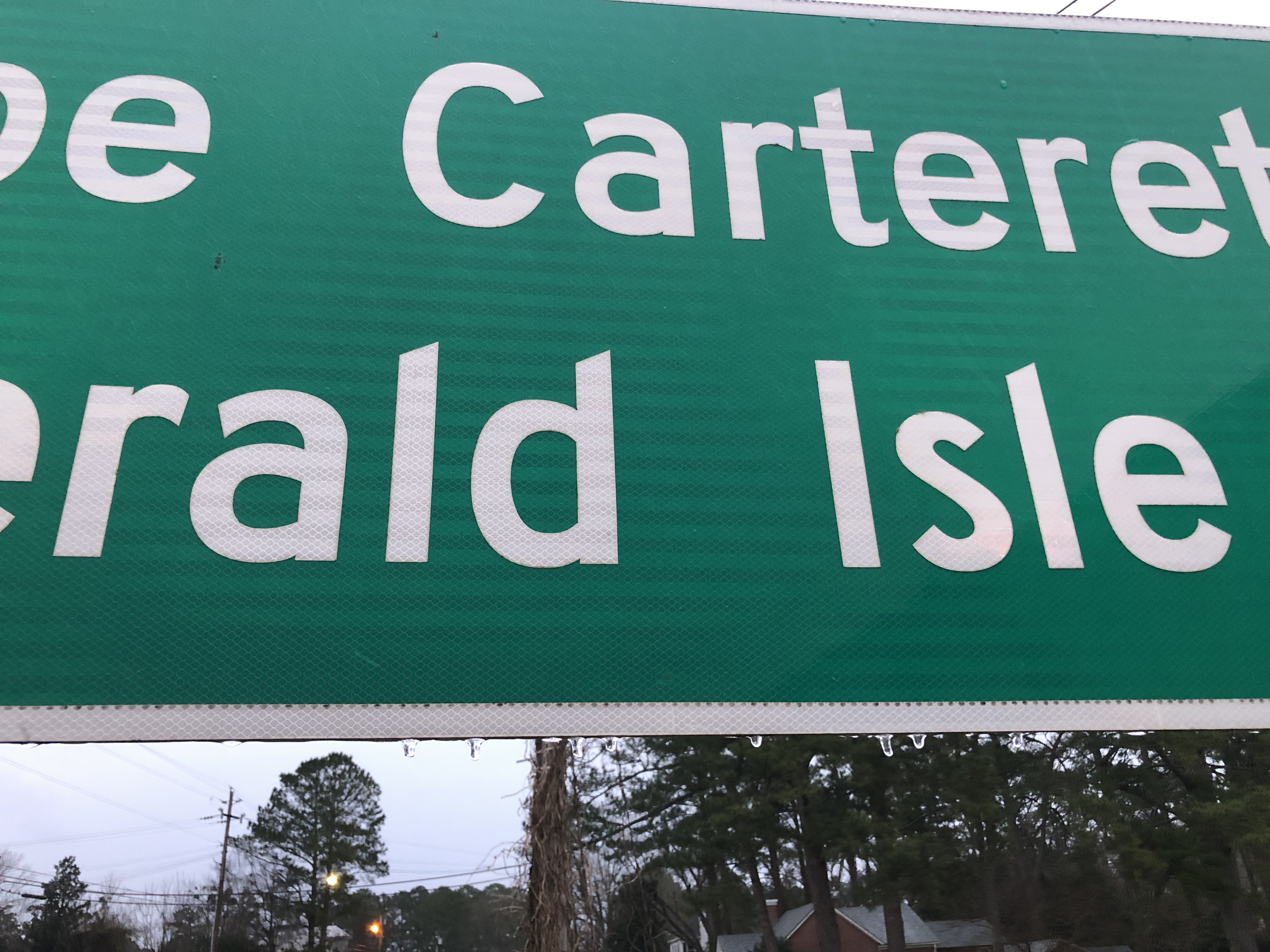
While we certainly did not see a major accumulation of ice across our area, any amount is noteworthy for our area. The blue shaded area on the map below shows where we had a light glaze of ice, especially on road signs or trees. No ice was reported on major roads. The areas that did see some light icing Sunday morning quickly warmed up by mid morning with plain rain the rest of the event.
Freezing Rain/Sleet/Snow Reports
PUBLIC INFORMATION STATEMENT NATIONAL WEATHER SERVICE NEWPORT/MOREHEAD CITY NC 203 PM EST SUN JAN 16 2022 WINTER WEATHER REPORTS SINCE MIDNIGHT ...SLEET REPORTS... LOCATION AMOUNT TIME/DATE PROVIDER ...NORTH CAROLINA... ...BEAUFORT COUNTY... 1 ENE PANTEGO T IN 0615 AM 01/16 PUBLIC ...CARTERET COUNTY... 1 SW NEWPORT T IN 0250 AM 01/16 OFFICIAL NWS OBS ...ONSLOW COUNTY... ALBERT J ELLIS AIRPORT T IN 0156 AM 01/16 ASOS SWANSBORO T IN 0200 AM 01/16 PUBLIC ...PITT COUNTY... 1 NE FARMVILLE T IN 0620 AM 01/16 PUBLIC 1 NE SIMPSON T IN 0621 AM 01/16 PUBLIC ...SNOWFALL REPORTS... LOCATION AMOUNT TIME/DATE PROVIDER ...NORTH CAROLINA... ...PITT COUNTY... 2 N WINTERVILLE T IN 0625 AM 01/16 PUBLIC ...FREEZING RAIN REPORTS... LOCATION AMOUNT TIME/DATE PROVIDER ...NORTH CAROLINA... ...CRAVEN COUNTY... 2 SSE GARDNERVILLE T IN 0658 AM 01/16 PUBLIC 1 SSE TRENT WOODS T IN 0730 AM 01/16 COCORAHS ...DUPLIN COUNTY... 3 ENE BEAUTANCUS T IN 1200 AM 01/16 COCORAHS 1 W BOWDENS T IN 0800 AM 01/16 TRAINED SPOTTER ...GREENE COUNTY... 3 WSW LIZZIE T IN 0700 AM 01/16 COCORAHS ...JONES COUNTY... MAYSVILLE 0.01 IN 0732 AM 01/16 NWS EMPLOYEE 3 E BELGRADE T IN 0727 AM 01/16 PUBLIC ...LENOIR COUNTY... 1 WSW KINSTON REGIONAL JETPO T IN 0649 AM 01/16 PUBLIC ...ONSLOW COUNTY... 1 NE BELGRADE 0.01 IN 0727 AM 01/16 NWS EMPLOYEE ...PITT COUNTY... WINTERVILLE T IN 0855 AM 01/16 PUBLIC GREENVILLE T IN 0917 AM 01/16 BROADCAST MEDIA && |
While it was breezy across the entire area Sunday into Sunday night, the stronger winds, above tropical storm force, were mainly confined to the coast. This was especially true from Carteret County through the Outer Banks. Later in the day a stronger area of heavier rain (with lightning off the coast) moved through these areas. This squall produced a wind gust to 49 MPH at Bogue Field in Bogue, along the Crystal Coast.
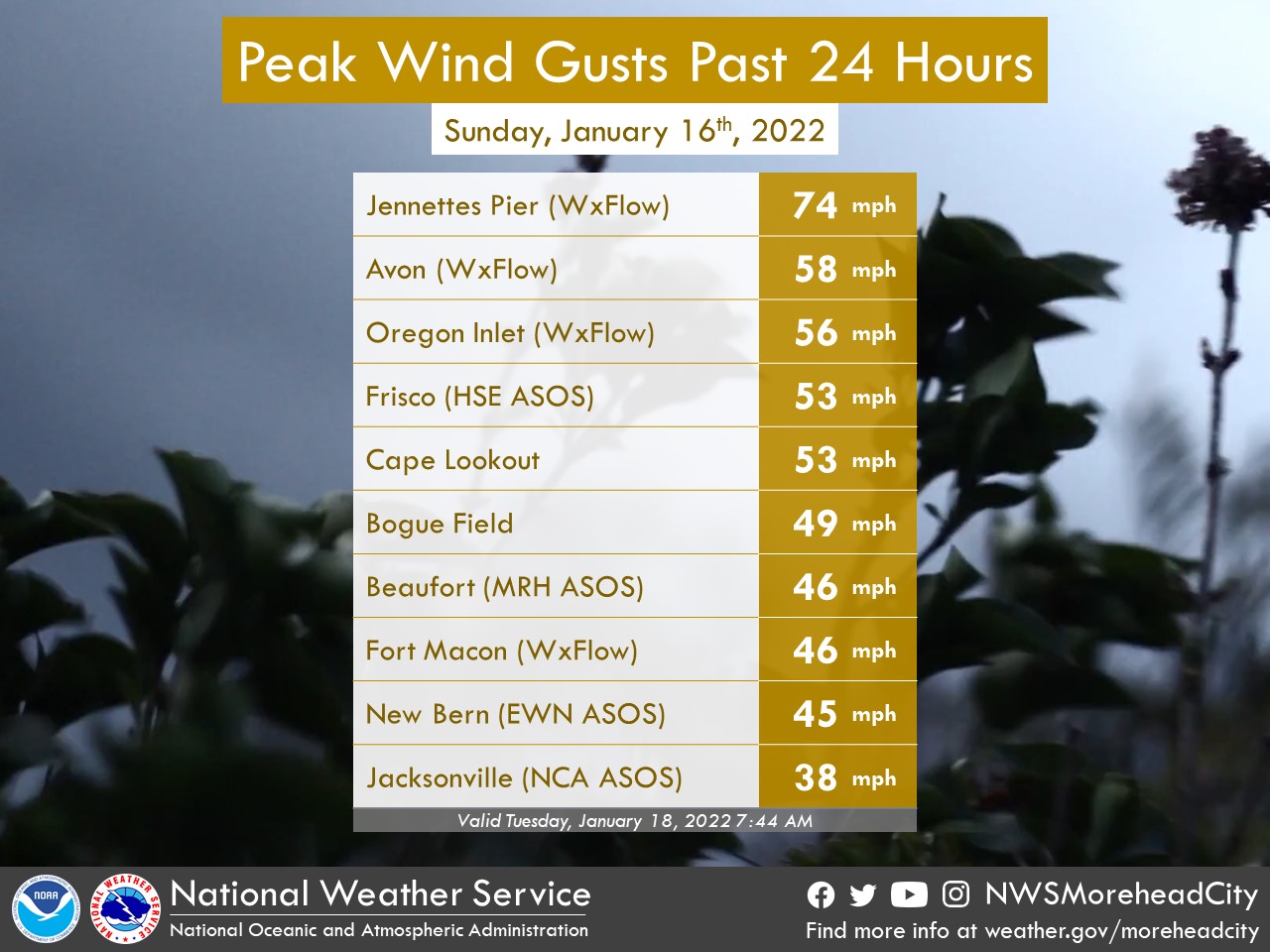
PUBLIC INFORMATION STATEMENT NATIONAL WEATHER SERVICE NEWPORT/MOREHEAD CITY NC 1012 PM EST SUN JAN 16 2022 ...MAX WIND GUSTS REPORTS OVER THE LAST 12 HOURS... LOCATION SPEED TIME/DATE PROVIDER ...NORTH CAROLINA... ...CARTERET COUNTY... CAPE LOOKOUT 53 MPH 0500 PM 01/16 NDBC BOGUE FIELD (NJM ASOS) 49 MPH 0510 PM 01/16 AWOS PINEY ISLAND (NBT AWOS) 48 MPH 0629 PM 01/16 AWOS BEAUFORT (MRH ASOS) 46 MPH 0559 PM 01/16 ASOS FORT MACON (WXFLOW) 46 MPH 0600 PM 01/16 WXFLOW BEAUFORT (DUKE MARINE LAB) 42 MPH 0448 PM 01/16 NOS-NWLON EMERALD ISLE 38 MPH 0505 PM 01/16 DAVIS CEDAR ISLAND RAWS 35 MPH 0225 PM 01/16 RAWS ...CRAVEN COUNTY... NEW BERN (EWN ASOS) 45 MPH 0550 PM 01/16 ASOS CHERRY POINT (NKT ASOS) 45 MPH 0558 PM 01/16 AWOS NEW BERN RAWS 38 MPH 0617 PM 01/16 RAWS ...DARE COUNTY... AVON (WXFLOW) 58 MPH 0717 PM 01/16 WXFLOW BUXTON (WXFLOW) 57 MPH 0732 PM 01/16 WXFLOW OREGON INLET CG (WXFLOW) 56 MPH 0758 PM 01/16 WXFLOW KHK RESORT (WXFLOW) 56 MPH 0809 PM 01/16 WXFLOW FRISCO (HSE ASOS) 53 MPH 0716 PM 01/16 ASOS REAL SLICK (WXFLOW) 51 MPH 0754 PM 01/16 WXFLOW OREGON INLET (WXFLOW) 48 MPH 0516 PM 01/16 WXFLOW MANTEO (MQI AWOS) 45 MPH 0755 PM 01/16 AWOS DARE CO GNRY RAN (2DP AWOS) 43 MPH 0733 PM 01/16 AWOS OREGON INLET MARINA 40 MPH 0824 PM 01/16 NOS-NWLON HATTERAS HIGH (WXFLOW) 39 MPH 0735 PM 01/16 WXFLOW OREGON INLET MARINA 38 MPH 0524 PM 01/16 NOS-NWLON DARE BOMB RANGE RAWS 37 MPH 0428 PM 01/16 RAWS KILL DEVIL HILLS 35 MPH 0435 PM 01/16 DAVIS ...HYDE COUNTY... ENGELHARD (7W6 AWOS) 36 MPH 0715 PM 01/16 AWOS OCRACOKE 35 MPH 0530 PM 01/16 DAVIS ...ONSLOW COUNTY... JACKSONVILLE (NCA ASOS) 38 MPH 0446 PM 01/16 AWOS RICHLANDS (OAJ AWOS) 36 MPH 0440 PM 01/16 AWOS ...WASHINGTON COUNTY... TIDEWATER RESEARCH STATION 37 MPH 0355 PM 01/16 NC-ECONET ...MARITIME STATIONS... JENNETTES PIER (WXFLOW) 74 MPH 0803 PM 01/16 WXFLOW DIAMOND BUOY (41025) 63 MPH 0800 PM 01/16 NDBC OCRACOKE (WXFLOW) 63 MPH 0647 PM 01/16 WXFLOW PAMLICO SOUND (WXFLOW) 51 MPH 0724 PM 01/16 WXFLOW DUCK PIER 50 MPH 0736 PM 01/16 NOS-NWLON NORTH RIVER 48 MPH 0513 PM 01/16 WXFLOW ROANOKE SOUND CHANNEL (WXFLO 47 MPH 0716 PM 01/16 WXFLOW AVON SOUND (WXFLOW) 46 MPH 0739 PM 01/16 WXFLOW CROATAN SOUND 45 MPH 0715 PM 01/16 WXFLOW && |
Videos
Coming Soon
Pictures
Highway 58 a few miles south of Maysville, along Blueburry Farm Road. Sunday morning around 730 AM (1/16/2022). Credit Erik Heden.
January 16th, 2022 Maysville
|
Highway 58. Maysville. Credit: Erik Heden.
|
Highway 58. Maysville. Credit: Erik Heden.
|
Highway 58. Maysville. Credit: Erik Heden.
|
Marine
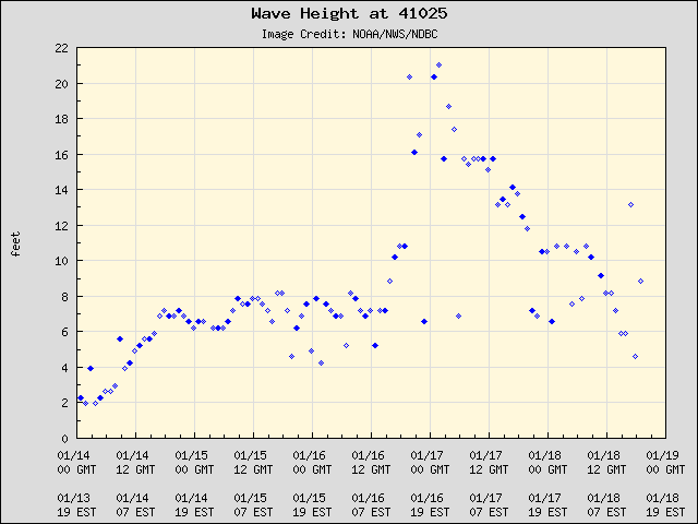
The Diamond Shoals buoy is located less than 20 miles off from Cape Point on Hatteras Island. Waves peaked at around 21 feet on the evening of the 16th (Sunday night).
Impacts
***Check back for more soon***


 Map View
 Weather Hazard Briefing (when applicable)
 Forecaster Discussion
 Marine
 Text Products
.png) Skywarn
Skywarn Submit Storm Reports
 Coastal Flood
.png) Surf Forecast/Rip Currents
Surf Forecast/Rip Currents