
Tropical system in the Gulf expected to gradually strengthen the next couple of days off the Florida Panhandle and Alabama coasts. Instances of flash flooding will be possible through Thursday along the eastern and central Gulf Coast. Severe thunderstorms will develop and move along a cold front crossing the Upper Midwest, and through the Ohio Valley/Mid-Atlantic on Tuesday. Read More >
Snow Friday Night and Saturday, Turning Much Colder
The image below shows a winter storm expected to track from Oklahoma to the Mid Atlantic this weekend. Normally, for our area to see a major winter storm, we would like to see the center of an intense low pressure system move across northeast Illinois/Indiana. This one is moving much farther south, from Arkansas to the Mid Atlantic states. So, we're not expected a major, widespread winter storm for southern Wisconsin.
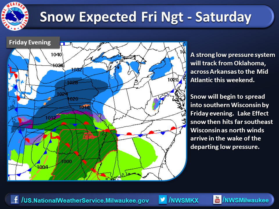
In the wake of the departing low, cold north winds flowing down Lake Michigan will likely generate some Lake Effect snowfall for southeast Wisconsin, especially Milwaukee, Racine and Kenosha counties. This would mainly be for late Friday night into Saturday night.
Due to the Lake Effect contribution, far southeast Wisconsin will have the best chance of seeing accumulating snow due to the Lake Effect potential. Amounts farther inland will be lower. Given how far south the center of the low is tracking, confidence is not very high right now on exact snow amounts, so expect many adjustments as we approach the start of the snow at the end of the work week.
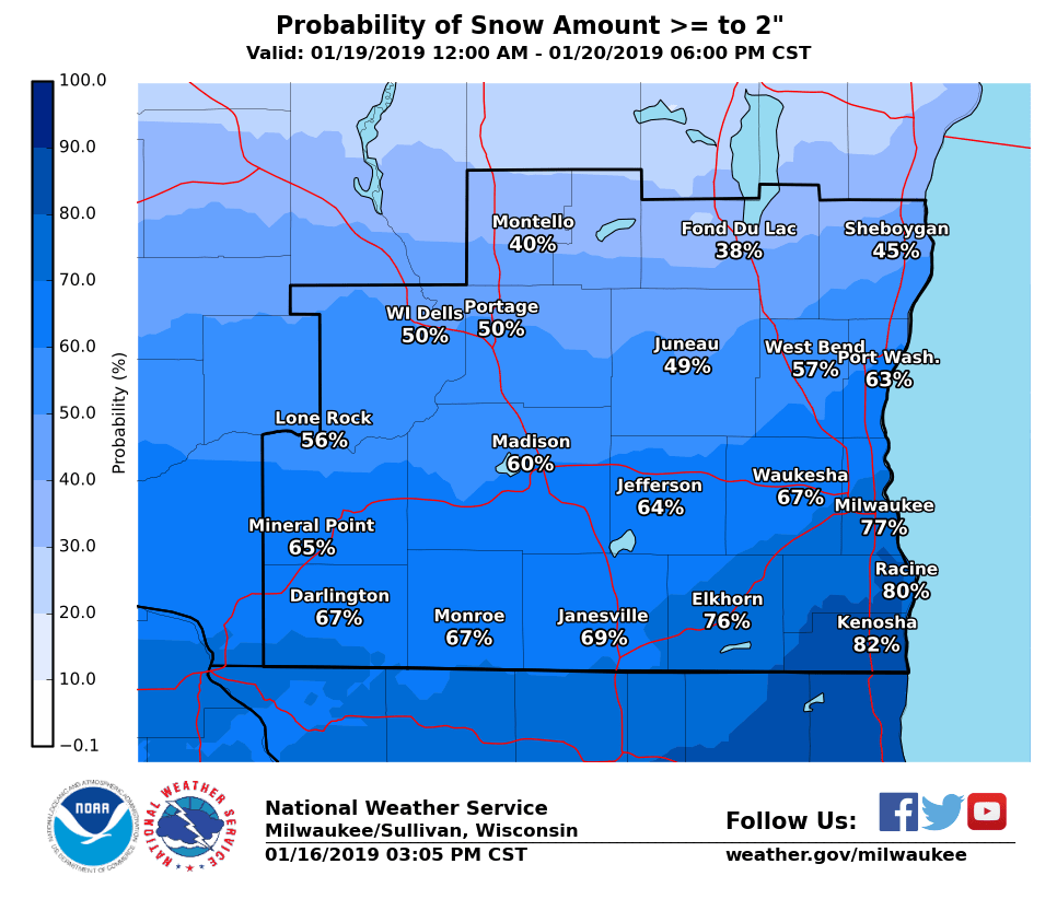
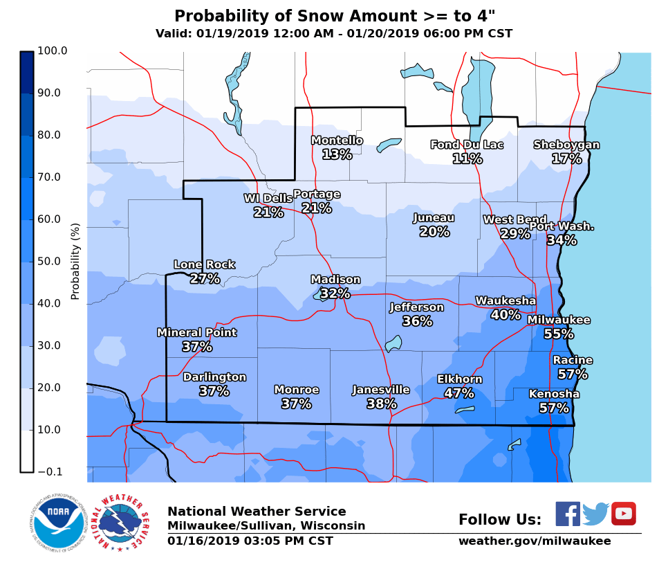
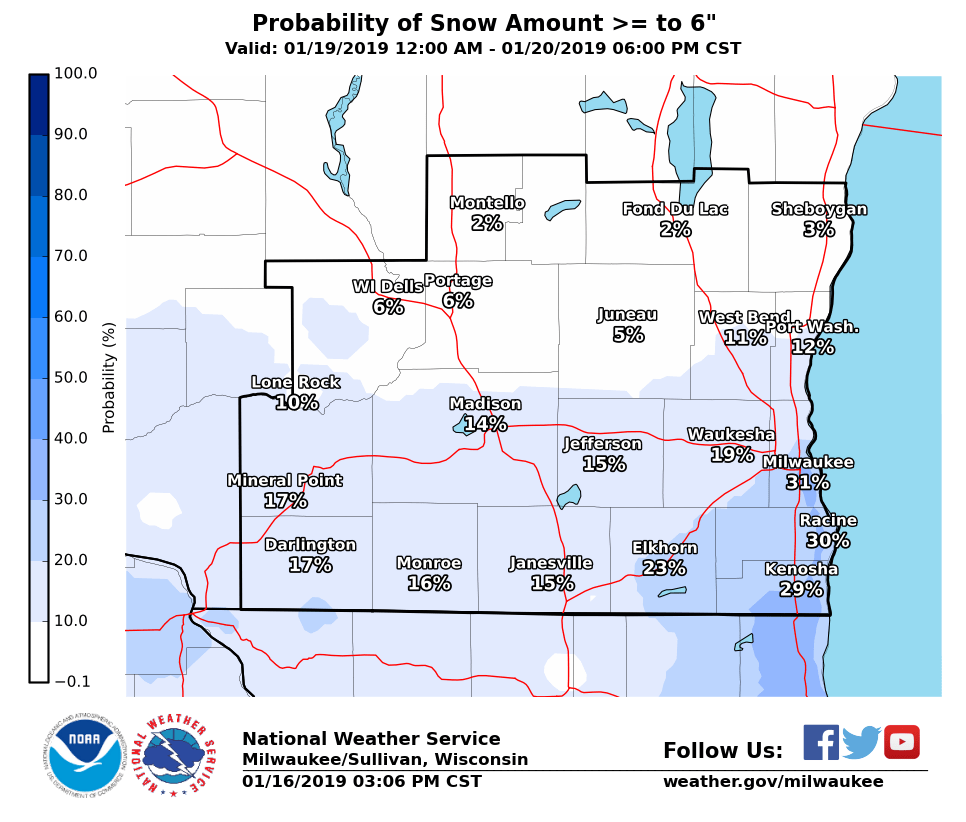
The images below are what fall out of a statistical analysis of many computer models. These show the probability of getting more than 2, 4 and 6 inches of snow. As many of you know, we have U.S., European, Canadian and Ensemble models to help us gauge the uncertainty inherent with the prediction of the future state of the atmosphere. The total number of model solutions can exceed 40-50 and in some cases more. These graphics are also highlighting the risk for a greater snowfall across the southeast.
 |
 |
 |
Here's another statistical perspective. It's the 25th and 75th percentile range of snowfall. This shows a reasonable upper and lower bound to the expected snowfall. The 25th percentile plot means there is a 75 percent chance we'll see more than what is shown, but that also means there is a 25 percent chance it could be lower. The 75th percentile plot means there is a 75 percent chance it will be that much or less, or a 25 percent chance it will be higher. Got that? :) Again, note the higher amounts focused on the southeast.
.png) |
.png) |
For some of you, this may just look like a wishy-washy, dart board type of forecast. But, it's actually a far more useful forecast than just tossing out single numbers that almost certainly won't verify given the uncertainties and complexity in predicting weather, especially 3 to 4 days out.
Here's a map that shows the mostly likely snowfall for this storm. This will change as timing and resolution tighten up.
.png)
Then we turn cold for the weekend. Lows Sunday and Monday morning will be in the single digits, possibly dropping below zero in spots Monday morning.

Davis

