Milwaukee/Sullivan, WI
Weather Forecast Office
|
Severe Thunderstorms Possible This Afternoon and Tonight
Low pressure will move into Wisconsin this evening. If the atmosphere destabilizes enough from any morning showers and thunderstorms, a round of thunderstorms will be likely this afternoon and tonight, and would likely produce some severe storms. The hazards for the second round of storms will include the possibility of damaging winds, large hail, and a tornado or two. Keep up with the latest forecasts on the severe potential, along with possible heavy rainfall. Additional Information:
Day 2 Outlook - TEXT Rain Day 2 Outlook - TEXT Day 2 Outlook - WI Day 2 Outlook - S WI
|
|
Submit Report Hazardous Weather Outlook Latest Storm Reports
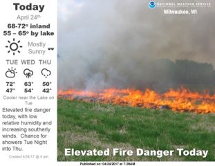
Weather Story 
Radar |
||||||||
Hazards
National Briefing
Hazardous Weather Outlook
Skywarn
View Local Storm Reports
Submit A Storm Report
Winter Weather
Summer Weather
Beach Hazards
Local Forecasts
Marine
Aviation
Fire
Local Text Products
Local Precip Forecast
Hourly Forecast Graphics
Forecast Discussion
Climate
Local Climate Products
Normals/Records MKE/MSN
CoCoRaHS
Historic Events For Srn WI
Lightning Plot Archive
Daily Climate Graphics
US Dept of Commerce
National Oceanic and Atmospheric Administration
National Weather Service
Milwaukee/Sullivan, WI
N3533 Hardscrabble Road
Dousman, WI 53118
262-965-2074
Comments? Questions? Please Contact Us.


