Tropical Depression Two is expected to gradually strengthen and could bring tropical storm conditions to the Florida Panhandle beginning late Monday. Areas of flash flooding will be possible through Thursday along the eastern and central Gulf Coast. Severe thunderstorms will develop and move along a cold front crossing the Upper Midwest Monday, and through the Ohio Valley/Mid-Atlantic on Tuesday. Read More >
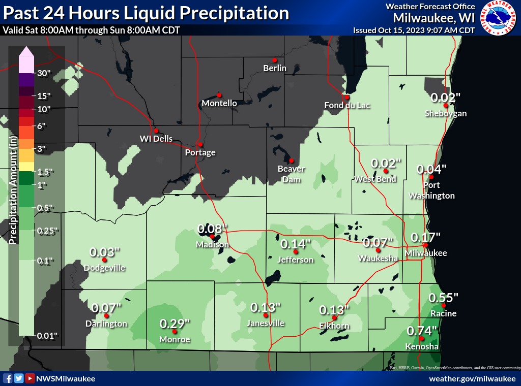
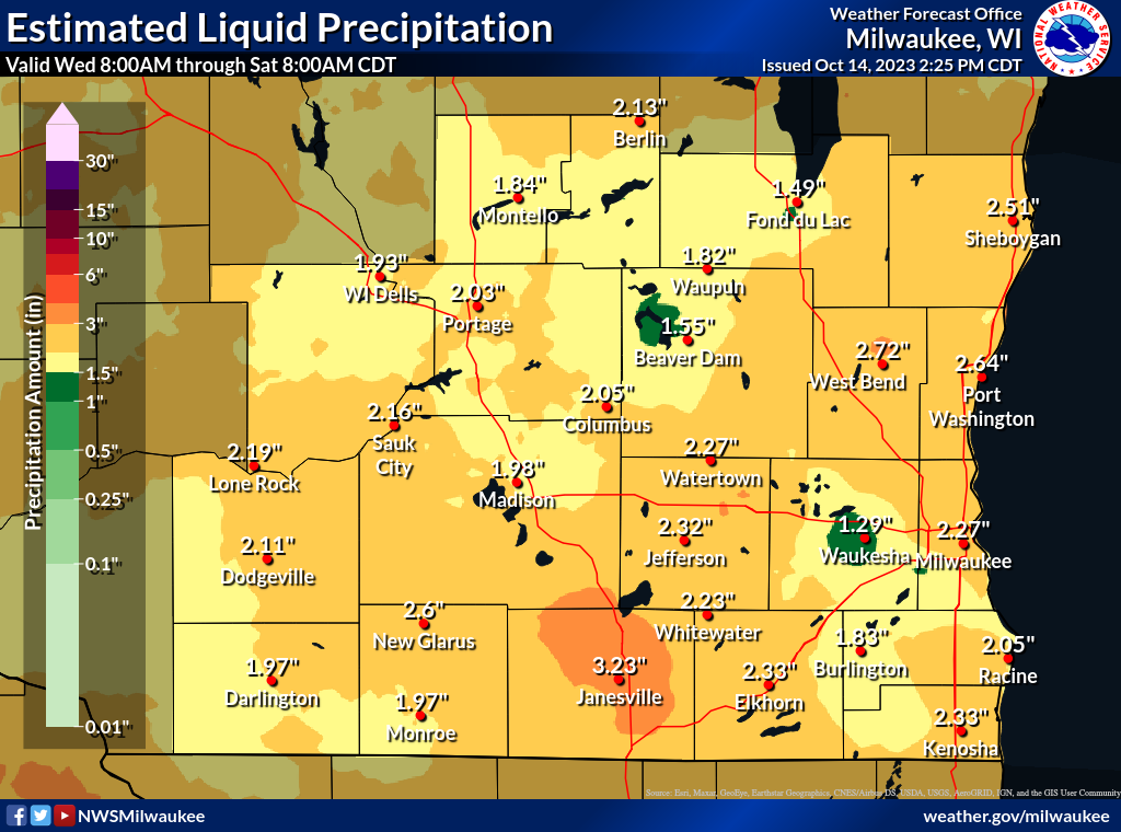
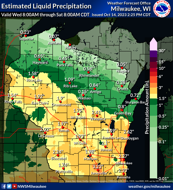
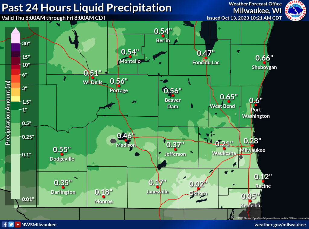
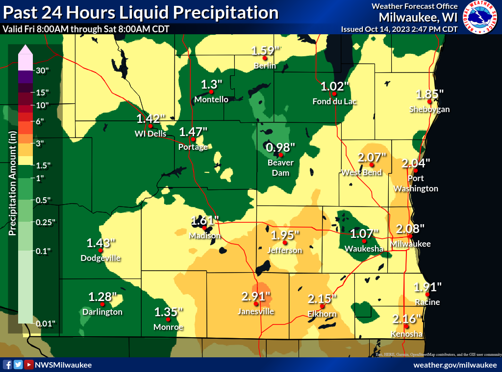
A slow-moving low pressure system drifted across the Upper Midwest and dropped 1 to 3 inches of much-needed rainfall across southern Wisconsin. The 4-day estimated rainfall totals and individual daily rainfall totals are based on observations and background model analysis information to produce these graphics. The points on the maps do not correlate directly with the actual amount that fell at that location. See the Public Information Statement (PNS) at the bottom for detailed rainfall reports.
 |
 |
| Wednesday Afternoon-Night (10/11) | Thursday - Thursday Night (10/12) |
 |
 |
| Friday - Friday Night (10/13) | Saturday (10/14) |
 |
|
Public Information Statement
National Weather Service Milwaukee/Sullivan WI
737 AM CDT Sun Oct 15 2023
...PRELIMINARY 3-DAY PRECIPITATION REPORTS...
Wednesday 10/11 Through Saturday Morning 10/14
Location Amount Time/Date
...Dane County...
Madison 4.3 WSW 2.59 in 0800 AM 10/14
Madison 6.1 W 2.58 in 0700 AM 10/14
Verona 1.3 SE 2.30 in 0800 AM 10/14
Madison 4.4 NE 2.17 in 0800 AM 10/14
Shorewood Hills 0.1 SE 2.17 in 0800 AM 10/14
...Dodge County...
Theresa 3.1 SE 2.51 in 0830 AM 10/14
Randolph 1.2 SE 2.50 in 0800 AM 10/14
Watertown 1.2 NNE 2.50 in 0800 AM 10/14
Brownsville 2.02 in 0700 AM 10/14
...Green County...
Belleville 1.7 ESE 2.31 in 0800 AM 10/14
...Jefferson County...
Palmyra 1 N 2.52 in 0700 AM 10/14
Lac LaBelle 1.2 SW 2.47 in 0733 AM 10/14
0.5 SW Lake Mills 2.18 in 0830 AM 10/14
...Kenosha County...
Kenosha 2.5 S 2.77 in 0813 AM 10/14
Pleasant Prairie 2.1 E 2.11 in 0700 AM 10/14
...Milwaukee County...
Fox Point 0.5 SSW 2.54 in 0700 AM 10/14
Milwaukee 3.6 NNW 2.48 in 0700 AM 10/14
...Ozaukee County...
Cedarburg 1.2 SSW 3.01 in 0730 AM 10/14
Mequon 2.7 ENE 2.85 in 0700 AM 10/14
Saukville 0.9 SSW 2.79 in 0700 AM 10/14
...Racine County...
Racine 2.8 NNE 2.37 in 0700 AM 10/14
Racine 5.2 N 2.05 in 0845 AM 10/14
...Rock County...
Milton-WWTP 3.23 in 0700 AM 10/14
Janesville 3.1 W 2.64 in 0700 AM 10/14
...Sheboygan County...
Random Lake-CoCoRaHS 3.01 in 0700 AM 10/14
Sheboygan 3 S 2.75 in 0700 AM 10/14
Sheboygan 1.7 NNE 2.35 in 0700 AM 10/14
Sheboygan 1.8 NE 2.34 in 0700 AM 10/14
Belgium 3.8 NW 2.18 in 0830 AM 10/14
...Walworth County...
Genoa City 2.7 NW 2.11 in 0709 AM 10/14
...Washington County...
Hartford 1.7 ESE 2.61 in 0843 AM 10/14
Richfield 2.8 WNW 2.36 in 0800 AM 10/14
Hartford 3.8 E 2.07 in 0700 AM 10/14
West Bend 2.07 in 0758 AM 10/14
...Waukesha County...
New Berlin 0.6 ESE 2.60 in 0700 AM 10/14
Menomonee Falls 2.0 NE 2.55 in 0700 AM 10/14
Oconomowoc 2.21 in 0700 AM 10/14
Oconomowoc 4.6 NE 2.21 in 0900 AM 10/14
Observations are collected from a variety of sources with varying
equipment and exposures. We thank all volunteer weather observers
for their dedication. Not all data listed are considered official.
$$