
Tropical system in the Gulf expected to gradually strengthen the next couple of days off the Florida Panhandle and Alabama coasts. Instances of flash flooding will be possible through Thursday along the eastern and central Gulf Coast. Severe thunderstorms will develop and move along a cold front crossing the Upper Midwest, and through the Ohio Valley/Mid-Atlantic on Tuesday. Read More >
Overview
A round of strong thunderstorms tracked across portions of southern Wisconsin during the afternoon and evening hours on August 1. Occurring within a warm and muggy air mass, these storms produced torrential downpours as they moved across the region. Some locations across south-central and southeastern Wisconsin picked up an inch or more of rainfall by the time storms departed. Multiple sightings of funnel clouds were also reported. This article takes a brief look back at how the August 1 event unfolded, in addition to the meteorology behind it.Radar
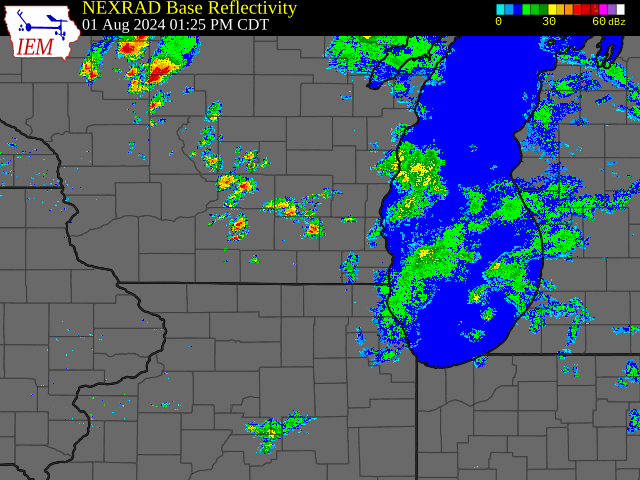 |
| Radar loop between 1:30 PM and 10:00 PM CDT on August 1. Radar data obtained from IEM Cow. Click on image to enlarge. |
Storm Reports
(1).png) |
| Image showing storm reports received during the August 1 thunderstorm event. Orange icons indicate funnel cloud reports, with blue squares marking locations of heavy rain reports. Image taken from the IEM Cow Storm Reports archive. Click on image to enlarge. |
Rain Reports
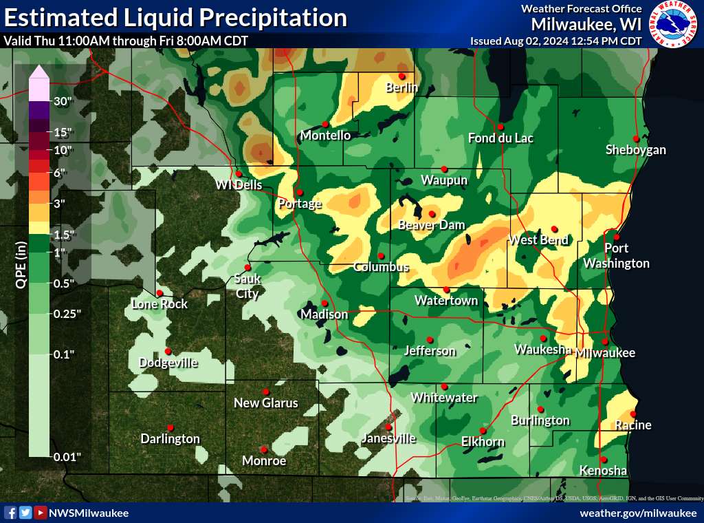 |
| Multi-radar multi-sensor (MRMS) precipitation estimates between 11:00 AM Thursday August 1 and 8:00 AM Friday August 2. Click on image to enlarge. |
Environment
An upper trough gradually migrated from Minnesota into central Wisconsin throughout the day on August 1 (figure 1). Beneath the progressing upper disturbance, surface low pressure was situated near the Mississippi River at the beginning of the day. The area of low pressure would migrate southeast through the afternoon hours, reaching far southeastern Wisconsin by early evening (figure 2). A cold front extended south and west of the low pressure center, sweeping across southern Wisconsin during the afternoon hours. A combination of lift ahead of the encroaching upper trough, as well as convergence along the cold front, created a synoptic environment broadly favorable for the development of precipitation during the afternoon hours on August 1.
.gif) |
.gif) |
| Figure 1: 500 millibar (mb) analyses at 12Z August 1 and 00Z August 2 (7 AM CDT and 7 PM CDT August 1). Maps obtained from the Storm Prediction Center upper air archive. Click on image to enlarge. | Figure 2: Animation of surface analyses from 12Z, 15Z, 18Z, and 21Z August 1, as well as 00Z August 2 (7 AM, 10 AM, 1 PM, 4 PM, and 7 PM CDT August 1 respectively). Surface maps obtained from the Weather Prediction Center surface analysis archive. Click on image to enlarge. |
Thanks to southerly winds ahead of the approaching cold front and upper disturbance, a warm and humid air mass from the Gulf of America was in place throughout the day on August 1. Breaking clouds and subsequent heating of this air mass allowed instability to build during the afternoon hours, providing fuel for the development of scattered showers and thunderstorms (figure 3). Once formed, poorly-organized and slow-moving storms capable of producing torrential downpours became favored thanks to an overlap of weak wind shear and very high precipitable water values in the near-storm environment (figures 4 and 5). Heavy rainfall thus ensued through the afternoon and evening hours, with south-central and southeastern Wisconsin being the hardest-hit.
.gif) |
.gif) |
.gif) |
| Figure 3: Mixed layer CAPE and CIN (abbreviated MLCAPE and MLCIN) at 15Z, 18Z, and 21Z August 1, as well as 00Z August 2 (10 AM, 1 PM, 4 PM, and 7 PM CDT August 1 respectively). MLCAPE is shown in red contours, with MLCIN shown in blue shading. Images taken from the Storm Prediction Center’s mesoscale analysis archive. Click on image to enlarge. | Figure 4: Effective bulk shear magnitudes (blue contours) and vectors (tan wind barbs) at 15Z, 18Z, and 21Z August 1, as well as 00Z August 2 (10 AM, 1 PM, 4 PM, and 7 PM CDT August 1 respectively). Images taken from the Storm Prediction Center’s mesoscale analysis archive. Click on image to enlarge. | Figure 5: Precipitable water values (in inches) at 15Z, 18Z, and 21Z August 1, as well as 00Z August 2 (10 AM, 1 PM, 4 PM, and 7 PM CDT August 1 respectively). Images taken from the Storm Prediction Center’s mesoscale analysis archive. Click on image to enlarge. |
While supportive of heavy rainfall, the near-storm environment was also conducive to the development of funnel clouds in thunderstorms developing on August 1. An abundance of surface vorticity was in place across southern Wisconsin thanks to converging winds ahead of the approaching cold front and low pressure center (figure 6). With plenty of instability present in the lower portions of the atmosphere, developing thunderstorms were able to vertically stretch the ambient surface vorticity into rotating funnel clouds. Due to weak prevailing wind shear and an attendant disorganized storm mode, funnel clouds were short-lived, dissipating before reaching the ground. Tornado warnings were thus unnecessary during the August 1 thunderstorm event, with the funnel cloud potential being addressed through Special Weather Statements (figure 7).
.gif) |
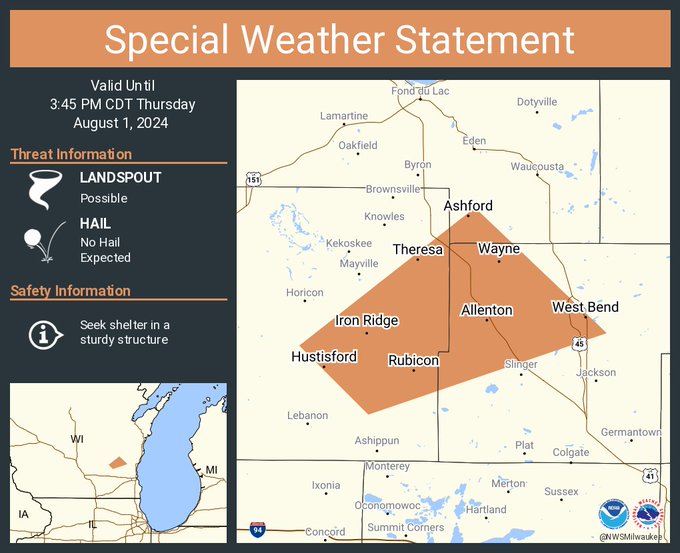 |
| Figure 6: Surface vorticity (blue contours) and 0-3 km MLCAPE (red contours) at 15Z, 18Z, and 21Z August 1, as well as 00Z August 2 (10 AM, 1 PM, 4 PM, and 7 PM CDT August 1 respectively). Images taken from the Storm Prediction Center’s mesoscale analysis archive. Click on image to enlarge. | Figure 7: Social media graphic of a Special Weather Statement issued for portions of Dodge, Fond du Lac, and Washington Counties on August 1. The Special Weather Statement messaged the potential for funnel clouds and landspouts. Special Weather Statements were used to message the funnel cloud potential on the afternoon of August 1, as individual funnel clouds were too short-lived to pose a threat of reaching the ground. Click on image to enlarge. |
 |
Media use of NWS Web News Stories is encouraged! Please acknowledge the NWS as the source of any news information accessed from this site. |
|

