Tropical system in the Gulf expected to gradually strengthen the next couple of days off the Florida Panhandle and Alabama coasts. Instances of flash flooding will be possible through Thursday along the eastern and central Gulf Coast. Severe thunderstorms will develop and move along a cold front crossing the Upper Midwest, and through the Ohio Valley/Mid-Atlantic on Tuesday. Read More >
Overview
|
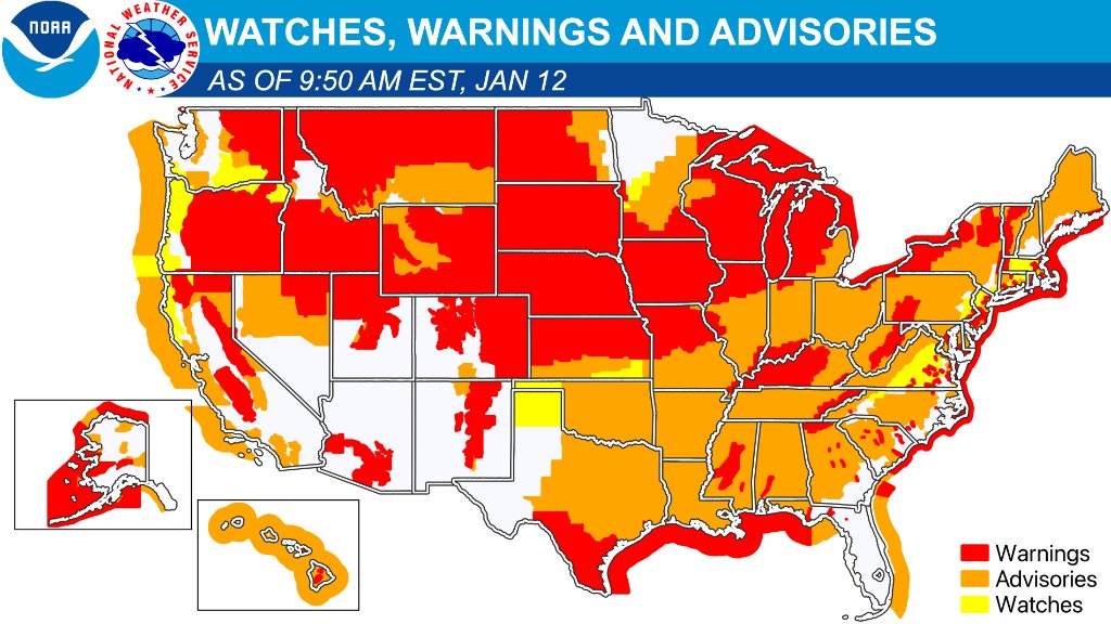
It was an active week across southern Wisconsin as winter finally arrived! After a mild and dry start to the winter season, there were two strong low pressure systems that impacted Wisconsin and dumped over a foot of snow in a span of 5 days, with pockets seeing over 2 feet in some spots! Not only did these systems produced heavy snow, blizzards across the U.S. it also brought flooding, severe thunderstorms, and tornadoes to other parts of the country. At one point there was at least one NWS Watch, Warning, or Advisory headline in all 50 states as captured at 8:50 AM CST on January 12th! In southern Wisconsin, the first strong low pressure system tracked across southern Illinois and brought heavy snow to inland portions of the area on Tuesday, January 9th. However warmer Lake Michigan water temps still sitting in the 40s and air temperatures hovering around freezing, limited snowfall amounts for areas closer to the lake, with even rain right up along the lakefront. Then a smaller, clipper system track across the area dropping another a few inches of fluffy snow early Thursday morning, January 11th. To wrap up the week, an even stronger low pressure system strengthened rapidly as it crossed Illinois and Lower Michigan and brought strong winds and heavy snow to the region. The late week dumped over a foot of snow across most of southern Wisconsin on Friday, January 12th. Again the warmer Lake Michigan water temps impacted snow amounts along the lake, but with temperatures at or below freezing it resulted in heavy wet snow just inland. This wetter, heavy snow accumulated on trees, powerlines, and other infrastructure causing lasting impacts across southeastern Wisconsin into the weekend. Snow eventually wrapped up later Saturday just before the bitter cold, Arctic airmass settled into the region.
|
NWS Watches, Warnings and Advisories at 8:50 AM CST 12 JAN
|
 |
 |
 |
|
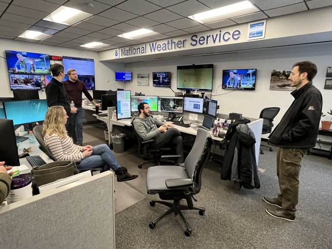
National Weather Service Milwaukee/Sullivan Meteorologist discussing the Winter Storm
|
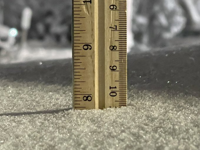
Snowfall Measurement on the west side of Madison from January 9, 2024 Winter Storm |
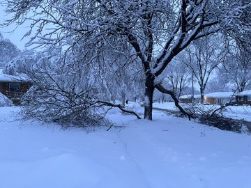
Tree Damage from heavy, wet snow in Greendale, WI from January 12, 2024 snow storm |
January 9, 2024 Winter Storm
Radar loop from midnight Jan 9, 2024 to midnight Jan 10, 2024
A sprawling winter storm impacted the east half of the country Monday night through Tuesday, January 9, 2024. The strong low pressure center tracked from the Texas Panhandle Monday morning (9 AM CST) to Southern Illinois Tuesday morning (9 AM CST), and to far eastern Quebec Wednesday morning. The low crossed northern Indiana Tuesday afternoon (3 PM CST). This track was favorable for heavy precipitation across eastern Iowa, southern Wisconsin and northern Illinois.
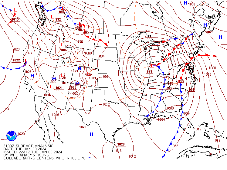
Mean Sea Level Pressure Surface Analysis at 21Z (3 PM CST) Jan 9, 2024
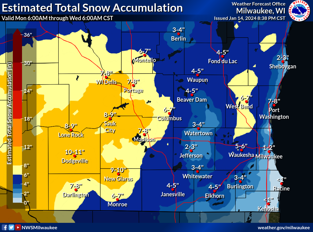
Here is a map of the estimated snowfall totals across southern Wisconsin. Most of the snow fell between 9 AM and 9 PM Tuesday, but 1 to 3 inches of light snow fell early Tuesday morning on the leading edge of the system. Highest snowfall totals were west of Madison and lowest were along the lakeshore where above warm Lake Michigan water temperatures in the 40s resulted in rain/snow mix and limited snowfall. There was also a local minimum from Fond du Lac to Watertown. The NWS Milwaukee/Sullivan office measured 5.6" total (halfway between Jefferson and Waukesha on the county line). Notice on the map below that there was a localized maximum in Washington and Waukesha Counties. This was due to some lake enhancement (the northeast winds gathered a little extra moisture off the lake) and a little extra lift from the hills of the Kettle Moraine.
Summary of Snowfall Totals:
Location                     Amount    Time/Date       Lat/Lon

...Wisconsin...

...Columbia County...
Portage 5.7 WSW              7.5 in    0600 AM 01/10   43.51N/89.57W
Lodi                         4.8 in    0926 PM 01/09   43.32N/89.53W

...Dane County...
1 SW Shorewood Hills         9.8 in    0800 AM 01/10   43.06N/89.46W
De Forest                    9.5 in    0827 PM 01/09   43.25N/89.35W
1 WSW Oregon                 9.0 in    1040 PM 01/09   42.92N/89.40W
1 W Oregon                   9.0 in    1040 PM 01/09   42.92N/89.40W
2 SSE Oregon                 9.0 in    0500 AM 01/10   42.90N/89.37W
Cross Plains                 8.2 in    0700 PM 01/09   43.11N/89.64W
Windsor                      8.2 in    1000 PM 01/09   43.22N/89.34W
3 NNE Verona                 8.0 in    0910 PM 01/09   43.03N/89.51W
2 NW Sun Prairie             8.0 in    1000 AM 01/10   43.20N/89.25W
1 NW Sun Prairie             8.0 in    1000 AM 01/10   43.20N/89.25W
2 SSE Middleton              7.8 in    1124 PM 01/09   43.08N/89.49W
1 SSW Oregon                 7.5 in    0720 PM 01/09   42.92N/89.39W
3 SW Shorewood Hills         7.5 in    0730 PM 01/09   43.05N/89.49W
Verona                       7.4 in    0830 PM 01/09   42.99N/89.53W
Windsor                      7.0 in    0600 PM 01/09   43.22N/89.33W
Windsor                      7.0 in    0600 PM 01/09   43.22N/89.34W
2 ESE Maple Bluff            7.0 in    1000 PM 01/09   43.10N/89.34W
Windsor 0.3 ENE              6.8 in    0700 AM 01/10   43.22N/89.34W
3 NNE Verona                 6.5 in    0324 PM 01/09   43.03N/89.50W
2 N Brooklyn                 6.3 in    0736 AM 01/10   42.88N/89.38W
Sun Prairie                  6.0 in    0647 PM 01/09   43.18N/89.23W
2 NNE Maple Bluff            5.7 in    1100 PM 01/09   43.14N/89.35W
1 SE Verona                  5.1 in    0340 PM 01/09   42.98N/89.52W
2 NNE Maple Bluff            4.8 in    0600 PM 01/09   43.14N/89.35W
3 SW Shorewood Hills         4.5 in    0300 PM 01/09   43.05N/89.49W
Cottage Grove 2.2 E          4.5 in    0700 AM 01/10   43.08N/89.16W
Madison 3.2 E                4.2 in    0700 AM 01/10   43.08N/89.32W
Cambridge                    3.9 in    0900 AM 01/10   43.00N/89.02W
1 E Maple Bluff              3.0 in    0210 PM 01/09   43.11N/89.35W
Verona 4.2 NNW               3.0 in    0700 AM 01/10   43.05N/89.55W

...Dodge County...
2 W Beaver Dam               6.0 in    0551 AM 01/10   43.47N/88.88W
2 WNW Beaver Dam             6.0 in    0551 AM 01/10   43.47N/88.88W
Mayville 0.5 NE              5.5 in    0600 PM 01/09   43.50N/88.54W
Theresa 0.1 ESE              4.5 in    0700 AM 01/10   43.52N/88.45W
2 WNW Beaver Dam             4.2 in    0511 PM 01/09   43.47N/88.88W
1 NE Horicon                 4.0 in    0539 PM 01/09   43.45N/88.63W
1 NNE Horicon                4.0 in    0539 PM 01/09   43.45N/88.63W
Iron Ridge                   3.9 in    0800 PM 01/09   43.40N/88.53W
3 SSW Clyman                 3.8 in    0420 PM 01/09   43.27N/88.75W
Mayville                     3.5 in    0539 PM 01/09   43.50N/88.55W

...Fond du Lac County...
1.8 E South Byron            3.5 in    1200 AM 01/10   43.63N/88.45W
St. Peter                    3.0 in    0700 AM 01/10   43.83N/88.35W
Fond Du Lac 1.7 E            2.0 in    0700 AM 01/10   43.77N/88.41W

...Green County...
Blanchardville 5.4 ESE       7.8 in    0642 AM 01/10   42.79N/89.76W
New Glarus                   7.1 in    0430 PM 01/09   42.81N/89.64W

...Green Lake County...
Berlin                       6.0 in    0557 AM 01/10   43.97N/88.95W

...Iowa County...
5 ENE Mineral Point          10.7 in   0834 PM 01/09   42.89N/90.10W
6 N Waldwick                 10.7 in   0932 PM 01/09   42.90N/90.05W
Dodgeville                   10.0 in   0915 PM 01/09   42.96N/90.13W
7 SE Avoca                   8.5 in    0800 PM 01/09   43.12N/90.21W
5 N Waldwick                 5.5 in    0130 PM 01/09   42.90N/90.06W

...Jefferson County...
4 SSE Sullivan               5.6 in    1200 AM 01/10   42.97N/88.55W
Fort Atkinson                5.5 in    0722 AM 01/10   42.93N/88.84W
Jefferson                    5.0 in    0900 PM 01/09   43.00N/88.81W
4 SSE Sullivan               4.9 in    0600 PM 01/09   42.97N/88.55W
Fort Atkinson 1.2 WNW        3.5 in    0700 AM 01/10   42.93N/88.86W
Jefferson 0.9 E              3.0 in    0653 AM 01/10   43.00N/88.79W
5 SW Fort Atkinson           3.0 in    0900 AM 01/10   42.87N/88.90W

...Lafayette County...
Benton                       10.0 in   0800 PM 01/09   42.57N/90.38W
Belmont                      8.5 in    0900 AM 01/10   42.74N/90.33W

...Milwaukee County...
1 SSW Greendale              3.1 in    0820 PM 01/09   42.92N/88.00W
Greenfield                   2.5 in    0539 PM 01/09   42.97N/88.00W
2 SSE Wauwatosa              2.1 in    0420 PM 01/09   43.04N/88.02W
1 SSW Greendale              2.0 in    0200 PM 01/09   42.92N/88.01W
Wauwatosa 1.9 E              2.0 in    0600 AM 01/10   43.06N/88.00W
Brown Deer 0.8 NW            2.0 in    0700 AM 01/10   43.18N/87.98W

...Ozaukee County...
2 W Fredonia                 6.8 in    1100 PM 01/09   43.47N/87.99W
Grafton                      3.5 in    0645 PM 01/09   43.32N/87.96W
Saukville 0.9 SSW            3.2 in    0700 AM 01/10   43.37N/87.95W
Mequon                       3.0 in    1100 PM 01/09   43.23N/87.98W
Saukville                    3.0 in    0630 AM 01/10   43.37N/87.94W
1 SW Mequon                  2.0 in    0421 PM 01/09   43.22N/88.00W

...Racine County...
3 E Waterford                2.5 in    0926 PM 01/09   42.76N/88.16W

...Rock County...
Evansville                   6.0 in    0800 PM 01/09   42.78N/89.30W
2 NE Janesville              4.5 in    1100 PM 01/09   42.71N/88.99W
1 WNW Beloit                 4.5 in    0900 AM 01/10   42.53N/89.03W
2 SW Janesville              4.5 in    0900 AM 01/10   42.66N/89.04W
Janesville 3.1 W             4.2 in    0700 AM 01/10   42.68N/89.08W
0.5 NE South Beloit          3.3 in    0530 AM 01/10   42.50N/89.03W
Beloit 3.3 E                 2.5 in    0700 AM 01/10   42.52N/88.96W

...Sauk County...
Plain                        11.5 in   0943 PM 01/09   43.28N/90.04W
3 W Lake Delton              10.5 in   0752 AM 01/10   43.59N/89.84W
Baraboo                      10.0 in   1100 PM 01/09   43.47N/89.74W
1 ESE Rock Springs           9.0 in    0602 PM 01/09   43.48N/89.90W
1 E Rock Springs             9.0 in    0602 PM 01/09   43.48N/89.90W
4 SW Lake Delton             9.0 in    1100 PM 01/09   43.55N/89.84W
2 NE Baraboo                 9.0 in    1100 PM 01/09   43.49N/89.72W
Baraboo                      8.5 in    1217 AM 01/10   43.47N/89.74W
3 W Lake Delton              8.0 in    0752 AM 01/10   43.59N/89.85W
Spring Green                 6.5 in    0900 PM 01/09   43.18N/90.06W
Lake Delton                  6.3 in    0625 PM 01/09   43.59N/89.78W
Prairie Du Sac               6.0 in    0700 PM 01/09   43.29N/89.73W

...Sheboygan County...
1 NNW Plymouth               7.0 in    0730 PM 01/09   43.76N/87.98W
1 SW Plymouth                7.0 in    0800 AM 01/10   43.73N/87.99W
1 SW Plymouth                7.0 in    0800 AM 01/10   43.73N/87.99W
Adell                        6.5 in    0800 PM 01/09   43.62N/87.95W
Plymouth 5.4 NE              2.0 in    0500 AM 01/10   43.81N/87.91W

...Walworth County...
1 WSW Williams Bay           5.5 in    1000 AM 01/10   42.57N/88.56W
1 W Elkhorn                  4.8 in    0506 PM 01/09   42.67N/88.56W
1 WNW Elkhorn                4.8 in    0506 PM 01/09   42.67N/88.56W
East Troy                    2.5 in    1158 PM 01/09   42.79N/88.40W

...Washington County...
1 SE Germantown              7.5 in    1030 PM 01/09   43.22N/88.10W
3 SSE Hubertus               6.0 in    0542 PM 01/09   43.20N/88.20W
Germantown 0.6 S             6.0 in    0700 AM 01/10   43.23N/88.12W
1 SE Germantown              5.8 in    0710 PM 01/09   43.23N/88.11W
4 NW Richfield               5.7 in    0815 PM 01/09   43.27N/88.30W
1.9 SE Hubertus              5.2 in    0600 AM 01/10   43.21N/88.21W
1 WNW Richfield              5.0 in    0600 PM 01/09   43.24N/88.25W
Richfield                    5.0 in    0600 PM 01/09   43.24N/88.25W
1.4 S Germantown             4.6 in    0700 AM 01/10   43.22N/88.12W
1 W Jackson                  4.5 in    0600 PM 01/09   43.32N/88.18W
Jackson                      4.5 in    0600 AM 01/10   43.32N/88.16W
Allenton 1.4 WSW             3.8 in    0600 AM 01/10   43.42N/88.37W

...Waukesha County...
1 ENE Merton                 7.1 in    0755 AM 01/10   43.14N/88.29W
2 NW Sussex                  6.1 in    0340 PM 01/09   43.16N/88.24W
Pewaukee                     4.5 in    0539 PM 01/09   43.08N/88.26W
1 WSW Butler                 4.4 in    0603 AM 01/10   43.10N/88.09W
2 N Oconomowoc               4.3 in    0721 AM 01/10   43.13N/88.49W
Hartland 5.0 NNE             4.1 in    0700 AM 01/10   43.16N/88.30W
2 NNW Brookfield             2.5 in    0120 PM 01/09   43.09N/88.13W
Mukwonago 5.3 W              2.4 in    0700 AM 01/10   42.85N/88.44W
Oconomowoc 2.3 WSW           2.2 in    0500 PM 01/09   43.09N/88.54W
1 W Muskego                  2.0 in    0610 PM 01/09   42.89N/88.14W
Muskego 1.1 WSW              2.0 in    0613 PM 01/09   42.88N/88.14W

Observations are collected from a variety of sources with varying
equipment and exposures. We thank all volunteer weather observers
for their dedication. Not all data listed are considered official.
Some people in southern Wisconsin would say "yes", while others would say "no". As you can see in the snowfall total map, the storm totals varied a lot across southern Wisconsin. Why did this happen? As with most winter storms, there are usually bands of heavier snow that develop within the general area of falling snow. One of the forcing mechanisms for these embedded bands of higher snowfall is frontogenesis. Areas west of Madison were under a band of upper level (600mb) frontogenesis while areas east of Madison did not have any dominant, stationary band. As a result, the forecast liquid precipitation for this event was higher than what actually occurred.
The other major factor that played into the lower snowfall totals for some (mainly east of Madison) was that the mild air caused the snow to be exceptionally wet or to be all rain instead of snow or a rain/snow mix. This was especially true along the lakeshore where steady east winds ushered the warmer lake air inland. The snow ratio, or the ratio of snow and liquid, ended up being very low in eastern Wisconsin. When snow ratios are less than 6:1, the snow/rain that reaches the ground is very slushy. For areas west of Madison, the snow ratios were higher, from 10:1 to 12:1, resulting in higher accumulations.
One other thing that cut down on the snowfall totals for southeast Wisconsin was the snowfall rate. The rates were not as high (transient or absent frontogenesis and other upper level forcing), so the lighter precipitation fell as rain or melted once it reached the near/above freezing ground. The snowfall rates are a key part of accumulating snow and if the temperatures are hovering around freezing and the snowfall rates are not high (less than 1" per hour), the snowfall amounts will be lower.
This graphic shows the last NWS MKX forecast issued before the main event began early Tuesday morning. There had already been 1 to 3 inches overnight, so that was included in this forecast snowfall total.
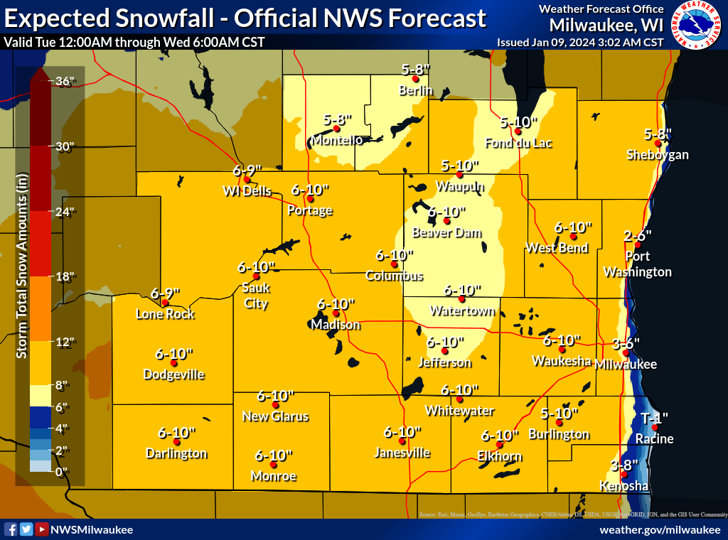
This was a tricky forecast as most of the models hinted at higher snowfall amounts. However with temperatures at or near freezing, a 1-3°F difference played a major role in precipitation type, snow ratios, snowfall character, and snowfall amounts. In the end, the forecast panned out for western areas while snowfall came up short for the eastern areas due to milder temps, wetter snow, more rain mixed in.
January 11, 2024 Snow
An upper level disturbance, or mid-level shortwave trough, quickly tracked across Iowa, northern Illinois and southern Wisconsin from late Wednesday (1/10) to the early Thursday (1/11) morning hours. This clipper was forecast to drop an additional few inches of fluffy snow across southern Wisconsin by Thursday morning. The snow ended up being being on the fluffier, drier side paired a bit more forcing resulted in widespread 1 to 3 inches with a swath of 2 to 4 inches from Dodgeville through Madison and eastward through north Milwaukee and Port Washington.
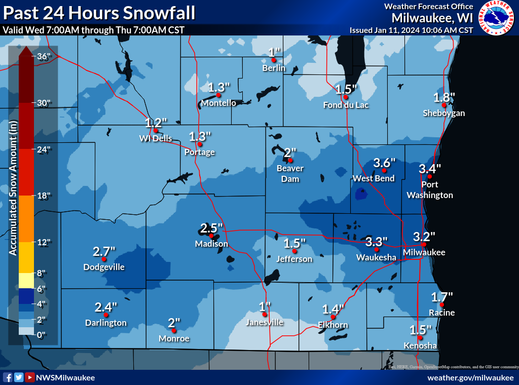
The map above shows the 24-hour snowfall ending at 7 AM Thursday, January 11, 2024.
January 12, 2024 Winter Storm
Radar loop from midnight Jan 12, 2024 to midnight Jan 13, 2024
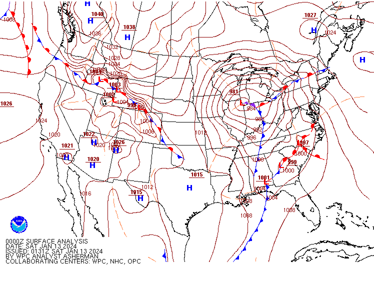
Mean Sea Level Pressure Surface Analysis at 6 PM CST on Jan 12, 2024 (00Z Jan 13)
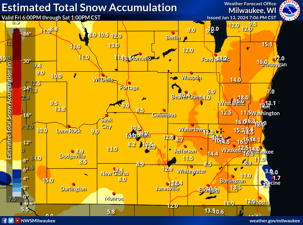
Summary of Snowfall Totals:
Location                     Amount    Time/Date       Lat/Lon

...Wisconsin...

...Columbia County...
1 ENE Lake Wisconsin         9.0 in    0900 AM 01/13   43.38N/89.55W

...Dane County...
Mount Horeb                  13.0 in   0900 AM 01/13   43.01N/89.73W
4 N Deerfield                12.5 in   1000 AM 01/13   43.11N/89.07W
1 NE Mcfarland               12.0 in   0930 AM 01/13   43.03N/89.28W
1 ESE Monona                 10.5 in   0900 AM 01/13   43.05N/89.31W
Waunakee                     10.5 in   0900 AM 01/13   43.19N/89.45W
3 NE Maple Bluff             9.7 in    0600 AM 01/13   43.14N/89.33W
2 N Brooklyn                 8.9 in    0919 AM 01/13   42.88N/89.38W

...Dodge County...
Horicon                      14.0 in   0900 AM 01/13   43.44N/88.64W
2 WNW Beaver Dam             10.4 in   0700 AM 01/13   43.47N/88.88W
Mayville                     6.0 in    0900 AM 01/13   43.50N/88.55W

...Fond du Lac County...
Campbellsport                14.0 in   0900 AM 01/13   43.60N/88.28W
Fond Du Lac                  12.0 in   0900 AM 01/13   43.78N/88.45W
1 ESE Fond Du Lac            11.2 in   1017 AM 01/13   43.78N/88.44W

...Green County...
1 N New Glarus               9.4 in    0900 AM 01/13   42.83N/89.63W
Monticello                   8.0 in    0900 AM 01/13   42.75N/89.59W

...Iowa County...
Arena                        9.0 in    0900 AM 01/13   43.16N/89.91W

...Jefferson County...
4 SSE Sullivan               14.4 in   0600 AM 01/13   42.97N/88.55W
Ixonia                       12.0 in   0900 AM 01/13   43.15N/88.60W
Fort Atkinson                11.5 in   0900 AM 01/13   42.93N/88.84W
Fort Atkinson                11.5 in   0747 AM 01/13   42.93N/88.84W
1 NNW Lake Mills             8.7 in    0815 AM 01/13   43.09N/88.92W
Palmyra                      8.5 in    0900 AM 01/13   42.88N/88.59W

...Milwaukee County...
2 SE Butler                  14.1 in   0802 AM 01/13   43.09N/88.05W
1 W West Allis               14.0 in   0900 AM 01/13   43.01N/88.06W
1 SSW Greendale              11.0 in   0827 AM 01/13   42.92N/88.00W
2 W Cudahy                   7.7 in    0600 AM 01/13   42.95N/87.90W

...Ozaukee County...
1 NNE Port Washington        13.1 in   0913 AM 01/13   43.40N/87.87W
Saukville                    12.0 in   0959 AM 01/13   43.38N/87.94W
1 WSW Mequon                 12.0 in   0900 AM 01/13   43.22N/88.00W
Saukville                    10.3 in   0910 AM 01/13   43.38N/87.94W
Mequon                       10.0 in   1000 AM 01/13   43.23N/87.98W

...Racine County...
Burlington                   13.5 in   1000 AM 01/13   42.68N/88.28W
3 S Wind Lake                11.0 in   0900 AM 01/13   42.78N/88.16W
2 N Elmwood Park             4.6 in    0700 AM 01/13   42.72N/87.83W
Sturtevant                   3.8 in    0700 AM 01/13   42.70N/87.90W
3 E Caledonia                3.0 in    0900 AM 01/13   42.82N/87.87W
North Bay                    1.7 in    0930 AM 01/13   42.76N/87.78W

...Rock County...
Edgerton                     12.9 in   1108 AM 01/13   42.84N/89.08W
3 NE Janesville              12.4 in   0900 AM 01/13   42.72N/88.97W
2 N Janesville               12.3 in   0900 AM 01/13   42.71N/89.01W
Beloit                       12.0 in   0900 AM 01/13   42.52N/89.02W

...Sheboygan County...
Plymouth                     16.0 in   1000 AM 01/13   43.75N/87.97W
3 N Kohler                   12.0 in   0900 AM 01/13   43.78N/87.77W

...Walworth County...
1 S Elkhorn                  13.0 in   0900 AM 01/13   42.65N/88.54W
Pell Lake                    11.0 in   1046 AM 01/13   42.54N/88.36W
1 W Elkhorn                  10.5 in   0600 AM 01/13   42.67N/88.56W

...Washington County...
2 N West Bend                18.0 in   0900 AM 01/13   43.45N/88.19W
1 NE Germantown              16.3 in   0945 AM 01/13   43.25N/88.11W
Hubertus                     16.0 in   1030 AM 01/13   43.24N/88.22W
3 W West Bend                16.0 in   0900 AM 01/13   43.42N/88.24W

...Waukesha County...
New Berlin                   16.5 in   0700 AM 01/13   42.97N/88.13W
3 ESE Pewaukee               16.0 in   1044 AM 01/13   43.07N/88.20W
2 NNW Brookfield             16.0 in   1000 AM 01/13   43.09N/88.13W
2 NNW Brookfield             16.0 in   1000 AM 01/13   43.09N/88.13W
2 NNW Sussex                 15.7 in   0755 AM 01/13   43.17N/88.24W
Menomonee Falls              14.5 in   0900 AM 01/13   43.15N/88.13W
1 W Delafield                14.5 in   0800 AM 01/13   43.07N/88.41W
3 ENE Waukesha               12.5 in   0700 AM 01/13   43.02N/88.19W
1 NE Oconomowoc              10.5 in   0952 AM 01/13   43.11N/88.49W
2 SSW Oconomowoc Lake        10.0 in   0930 AM 01/13   43.08N/88.47W
Oconomowoc                   9.7 in    1000 AM 01/13   43.10N/88.50W
Muskego                      8.9 in    0900 AM 01/13   42.89N/88.12W

Observations are collected from a variety of sources with varying
equipment and exposures. We thank all volunteer weather observers
for their dedication. Not all data listed are considered official.
 |
Media use of NWS Web News Stories is encouraged! Please acknowledge the NWS as the source of any news information accessed from this site. |
|