
Widespread life-threatening flash and urban flooding will continue to pose a significant threat to life and property in south-central Texas. Catastrophic fiver flooding, with rapid rises on small streams, arroyos, and typically dry washes, is expected. Monsoonal showers persist across the Great Basin and Southwest with greatest flash flooding in southern Arizona. Read More >
Overview
|
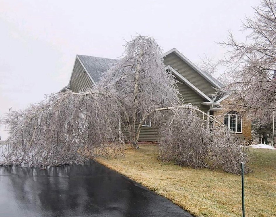
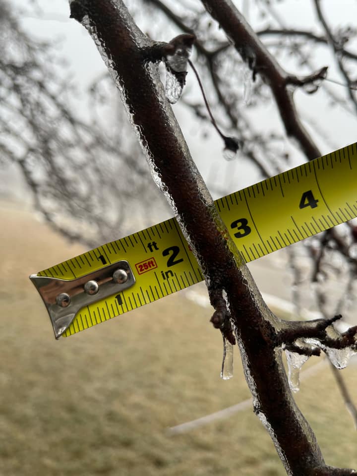
A surface low tracking northeast across southern Wisconsin brought widespread wintry precipitation to central and southern Wisconsin on February 22nd, 2023. Across central Wisconsin, precipitation remained primarily all snow during much of the event, while southern parts of Wisconsin saw accumulating sleet and freezing rain. Freezing rain resulted in icing reports from 0.10'' near Dodgeville, Wisconsin to 0.75'' near Burlington and Franksville, where Ice Storm Warnings were in effect. Racine, Kenosha, and Walworth counites were hit particularly hard. The combination of 0.50 to 0.75'' of ice accumulating on trees and powerlines, and strong winds throughout the duration of the event led to numerous power outages. Some of these power outages lasted for 1 to 2 days.
|
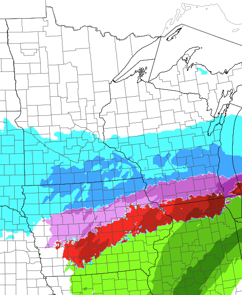 Image from the SPC HREF showing the sharp transition from snow (blue), to areas that saw accumulating sleet and mixed precipitation (purple), and freezing rain (red). |
Snow/Ice
 |
.png) |
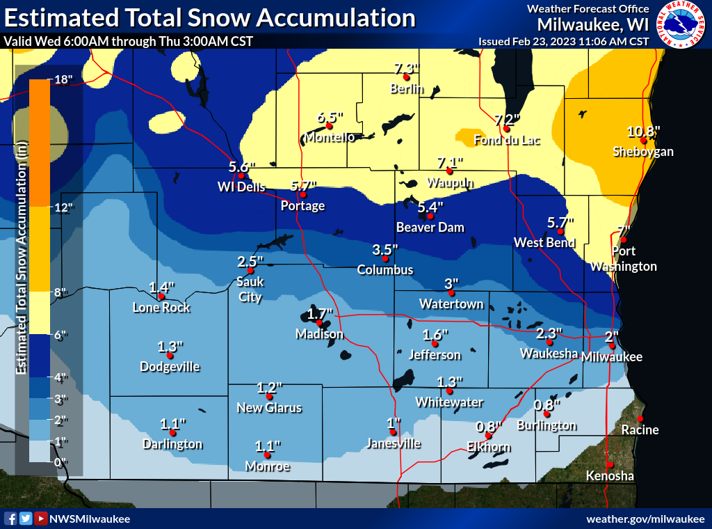
| Estimated Snow and Sleet Totals | Estimated Icing Totals |
PUBLIC INFORMATION STATEMENT
NATIONAL WEATHER SERVICE MILWAUKEE/SULLIVAN WI
210 PM CST THU FEB 23 2023

...FREEZING RAIN REPORTS...

LOCATION                     AMOUNT    TIME/DATE
1 S FRANKSVILLE              0.75 IN   1012 AM 02/23
BURLINGTON                   0.73 IN   0700 PM 02/22
3 ESE WIND LAKE              0.70 IN   0655 PM 02/22
2 SSE UNION GROVE            0.68 IN   0700 PM 02/22
GENOA CITY                   0.68 IN   0705 PM 02/22
KENOSHA AIRPORT              0.67 IN   0927 AM 02/23
RACINE-BATTEN AIRPORT        0.66 IN   0921 AM 02/23
1 SW CLINTON                 0.60 IN   0700 AM 02/23
DELAVAN                      0.53 IN   0710 PM 02/22
PELL LAKE                    0.50 IN   0256 PM 02/22
BENTON                       0.50 IN   0700 AM 02/23
1 SSW BELOIT                 0.50 IN   0800 AM 02/23
1 SSW RACINE                 0.30 IN   0623 AM 02/23
4 ESE JANESVILLE             0.25 IN   0234 PM 02/22
1 WSW WILLIAMS BAY           0.25 IN   0900 AM 02/23
2 WSW NEW GLARUS             0.22 IN   0700 AM 02/23
3 NE DODGEVILLE              0.10 IN   0700 AM 02/23


...SNOWFALL REPORTS...

Many of the snow reports that are less than 3 inches are
mostly due to sleet.


Location                     Amount    Time/Date
1 NW Plymouth                12.0 in   1250 AM 02/23
Lamartine                    12.0 in   0415 AM 02/23
Belgium 1 NW                 12.0 in   0730 AM 02/23
Sheboygan 0.7 SSW            10.7 in   0800 AM 02/23
1 ESE Fond Du Lac            10.4 in   0923 AM 02/23
Plymouth                     10.0 in   0933 PM 02/22
1 SSE Plymouth               10.0 in   1200 AM 02/23
Ripon                        10.0 in   1252 AM 02/23
2 N Kohler                   10.0 in   0628 AM 02/23
Belgium                      10.0 in   0720 AM 02/23
Eldorado 2.3 S               8.8 in    0718 AM 02/23
2 NNW Kohler                 8.5 in    0820 PM 02/22
Sheboygan                    8.5 in    0830 PM 02/22
Sheboygan 3.7 NW             8.5 in    0800 AM 02/23
Sheboygan 3.2 NW             8.1 in    0700 AM 02/23
1.4 S Germantown             7.6 in    0700 AM 02/23
Berlin                       7.5 in    0722 PM 02/22
1.8 E South Byron            7.5 in    1200 AM 02/23
Fond Du Lac 1 SW             7.5 in    0700 AM 02/23
Saukville 0.9 SSW            7.5 in    0700 AM 02/23
2 WNW Beaver Dam             7.1 in    0917 PM 02/22
2.0 SE Montello              7.0 in    0700 AM 02/23
Cedarburg 1.2 SSW            7.0 in    0730 AM 02/23
2 W Fredonia                 6.8 in    1253 AM 02/23
0.6 SW Markesan              6.8 in    0630 AM 02/23
Ripon                        6.5 in    0626 PM 02/22
Grafton                      6.5 in    1200 AM 02/23
St. Peter                    6.5 in    0655 AM 02/23
West Bend 5.4 SE             6.5 in    0800 AM 02/23
Beaver Dam 2.4 WNW           6.3 in    0700 AM 02/23
Reedsburg 1.3 N              6.0 in    0600 AM 02/23
Saukville                    6.0 in    0638 AM 02/23
Port Washington-CoCoRaHS     6.0 in    0700 AM 02/23
Grafton 1 S                  5.7 in    0700 AM 02/23
1 SE Grafton                 5.5 in    0200 AM 02/23
Green Lake 0.8 E             5.5 in    0700 AM 02/23
Germantown 0.6 S             5.5 in    0700 AM 02/23
West Bend 7.3 E              5.5 in    0700 AM 02/23
Random Lake-CoCoRaHS         5.2 in    0700 AM 02/23
Portage 5.7 WSW              5.0 in    0600 AM 02/23
Jackson 1 SW                 5.0 in    0600 AM 02/23
Theresa 0.5 SSW              4.6 in    0700 AM 02/23
Germantown                   4.6 in    0727 AM 02/23
1 S Sheboygan                4.5 in    0159 PM 02/22
2 WNW Beaver Dam             4.5 in    0403 PM 02/22
Beaver Dam 1.4 SSW           4.5 in    0800 AM 02/23
Kewaskum 1.8 WNW             4.3 in    0700 AM 02/23
Horicon-WWTP                 4.2 in    0700 AM 02/23
Saukville                    4.1 in    0630 AM 02/23
Hartford                     4.0 in    0638 PM 02/22
Theresa                      4.0 in    0740 PM 02/22
Germantown                   3.9 in    1200 AM 02/23
Brown Deer 0.8 NW            3.9 in    0700 AM 02/23
1 WSW Butler                 3.5 in    0608 AM 02/23
Merton                       3.5 in    0637 AM 02/23
Beaver Dam                   3.0 in    0430 PM 02/22
Watertown                    3.0 in    0630 PM 02/22
2 NNW Brookfield             3.0 in    0834 PM 02/22
Jackson 0.9 SSE              3.0 in    0600 AM 02/23
4 SSE Lime Ridge             3.0 in    0645 AM 02/23
Menomonee Falls 3.2 NNW      3.0 in    0700 AM 02/23
New Berlin 3.4 NE            3.0 in    0700 AM 02/23
Slinger 1 WNW                3.0 in    0700 AM 02/23
0.7 SW Hartford              3.0 in    0700 AM 02/23
Milwaukee 2.4 WNW            3.0 in    0700 AM 02/23
Wauwatosa 1.9 E              3.0 in    0700 AM 02/23
Waukesha 1.6 NW              2.7 in    0700 AM 02/23
Muskego 1.0 W                2.7 in    0745 AM 02/23
Waukesha 7.2 SSW             2.5 in    0800 AM 02/23
Greendale 1.0 NNE            2.3 in    0700 AM 02/23
2.9 W Brookfield             2.2 in    0632 AM 02/23
Mukwonago 5.3 W              2.2 in    0700 AM 02/23
Greendale 1.5 NW             2.2 in    0700 AM 02/23
Oconomowoc 1.2 W             2.0 in    0700 AM 02/23
Pewaukee 3.2 W               2.0 in    0700 AM 02/23
3 E Edgerton                 2.0 in    0700 AM 02/23
Sun Prairie 3.0 W            2.0 in    0700 AM 02/23
Muskego 1.0 NNE              1.8 in    0800 AM 02/23
Palmyra 1.9 SW               1.6 in    0700 AM 02/23
Stoughton 2.7 SSE            1.5 in    0600 AM 02/23
Deerfield 0.6 N              1.5 in    0630 AM 02/23
Janesville 3.1 W             1.5 in    0700 AM 02/23
Oconomowoc 0.9 W             1.5 in    0756 AM 02/23
Waterloo                     1.4 in    0733 AM 02/23
South Milwaukee-WWTP         1.3 in    0700 AM 02/23
Oregon 1.4 WNW               1.3 in    0700 AM 02/23

...SLEET REPORTS...

Location                     Amount    Time/Date
1 W Shorewood                3.3 in    0654 PM 02/22
New Berlin                   2.5 in    0741 PM 02/22
Franklin                     2.3 in    1200 AM 02/23
1 NNW Oconomowoc             1.8 in    0617 AM 02/23
2 W Cudahy                   1.5 in    0600 AM 02/23
3 NE Maple Bluff             1.5 in    0600 AM 02/23
1 NW West Milwaukee          1.4 in    0600 PM 02/22
2 SE Waukesha                1.3 in    0645 PM 02/22
3 NE Dodgeville              1.1 in    0508 PM 02/22
Johnson Creek                1.0 in    0700 PM 02/22
Monticello                   1.0 in    0654 AM 02/23
4 SE Sullivan                0.7 in    0600 PM 02/22
2 WSW Saint Francis          0.6 in    0600 PM 02/22
Janesville                   0.3 in    0254 PM 02/22

Observations are collected from a variety of sources with varying
equipment and exposures. We thank all volunteer weather observers
for their dedication. Not all data listed are considered official.
Photos & Video
 |
 |
 |
 |
|
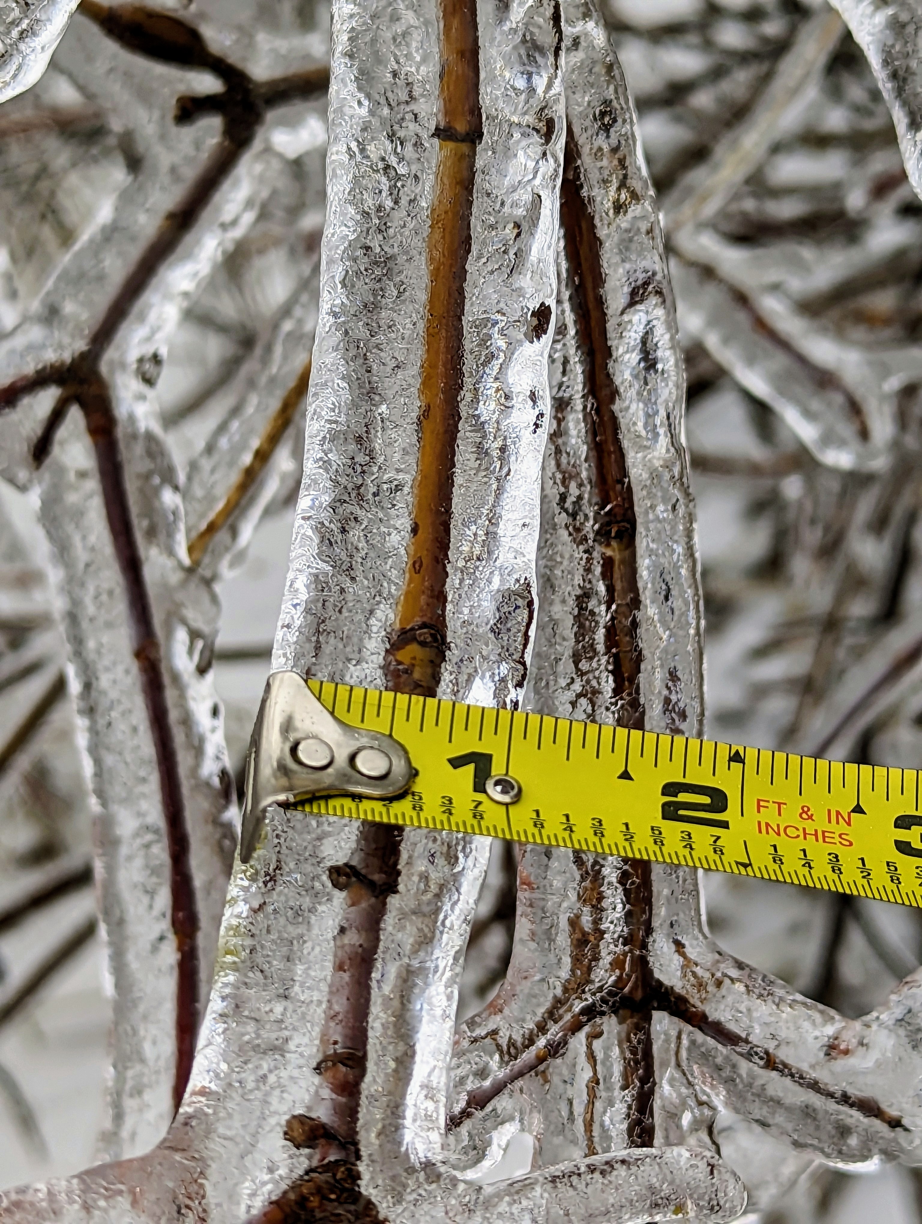
1/2 Inch of Ice Franksville |
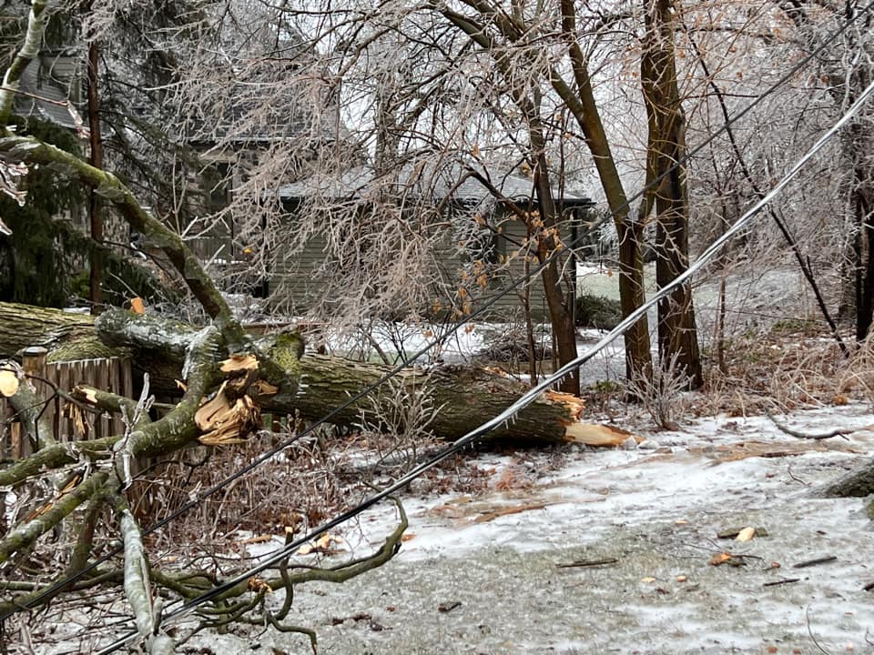
Trees/branches down due to Ice Lake Geneva |
Trees bending under weight of Ice Wheatland |
1/4 Inch of Ice Kenosha |
 |
Media use of NWS Web News Stories is encouraged! Please acknowledge the NWS as the source of any news information accessed from this site. |
|

