
Tropical system in the Gulf expected to gradually strengthen the next couple of days off the Florida Panhandle and Alabama coasts. Instances of flash flooding will be possible through Thursday along the eastern and central Gulf Coast. Severe thunderstorms will develop and move along a cold front crossing the Upper Midwest, and through the Ohio Valley/Mid-Atlantic on Tuesday. Read More >
Overview
|
Multiple rounds of severe thunderstorms impacted southern Wisconsin from the afternoon of July 13 through the evening of July 15. Occurring within a warm, muggy, and unstable air mass in place across the region, these rounds of storms brought large hail, damaging winds, as well as torrential rainfall to portions of the NWS Milwaukee/Sullivan county warning area. This overview provides a brief recap of the active period of weather. A deeper dive on the event will be provided in a future GIS story map. |
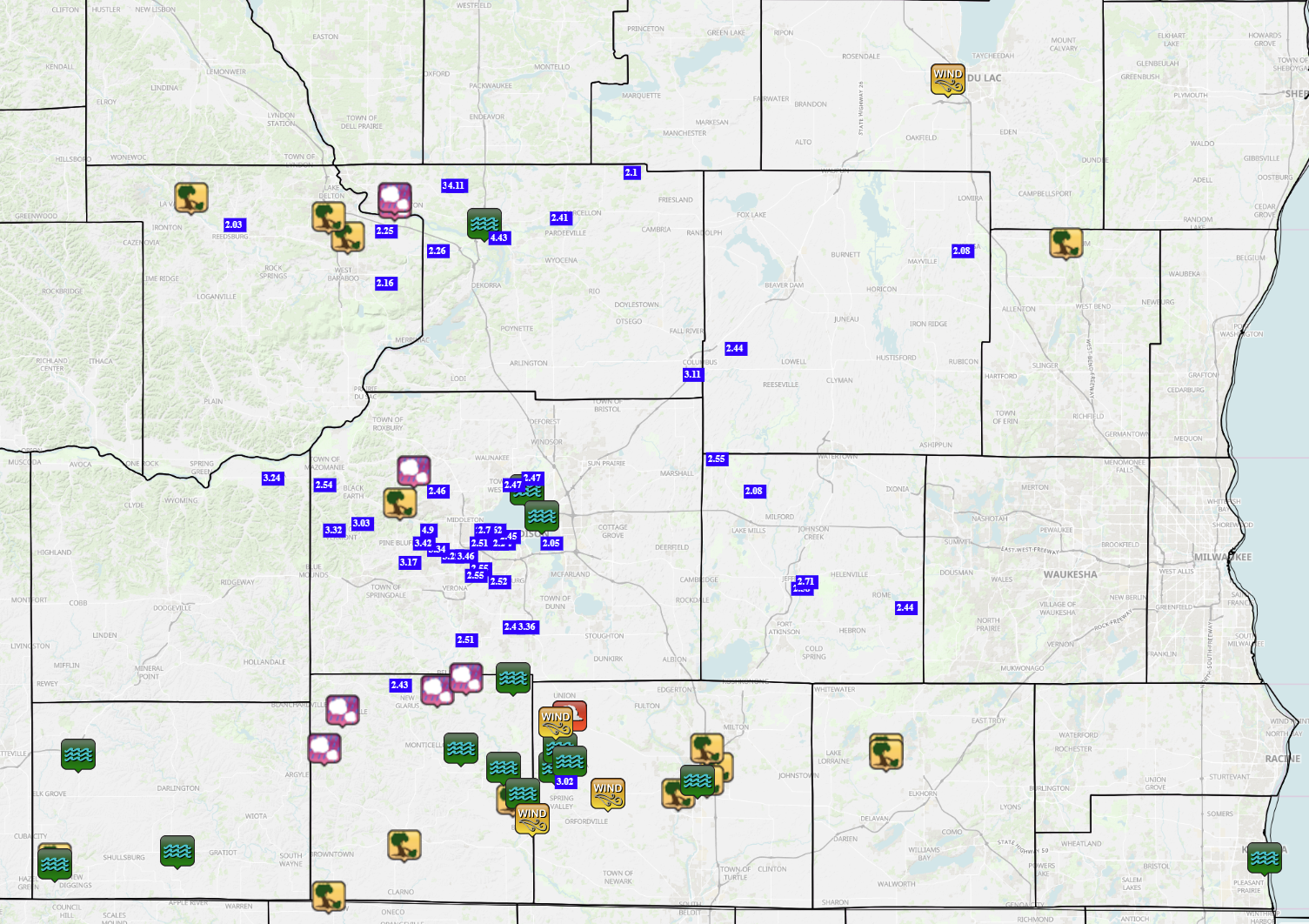
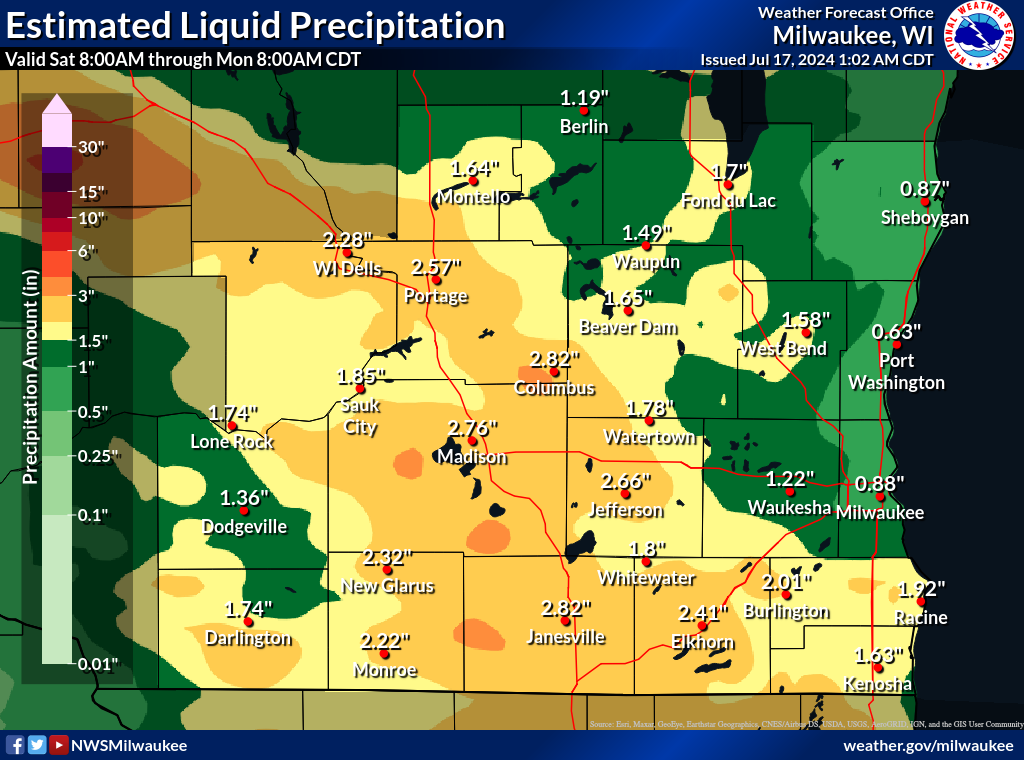 Observed rainfall between 7:00 AM July 13 and 7:00 AM July 16. |
Radar
 |
 |
 |
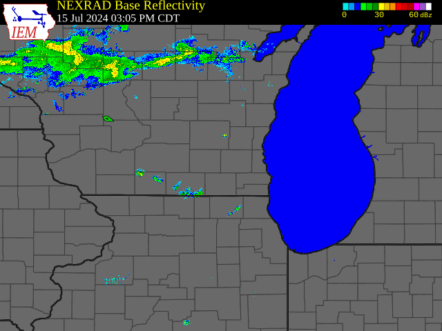 |
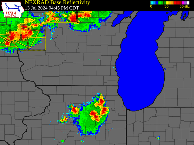
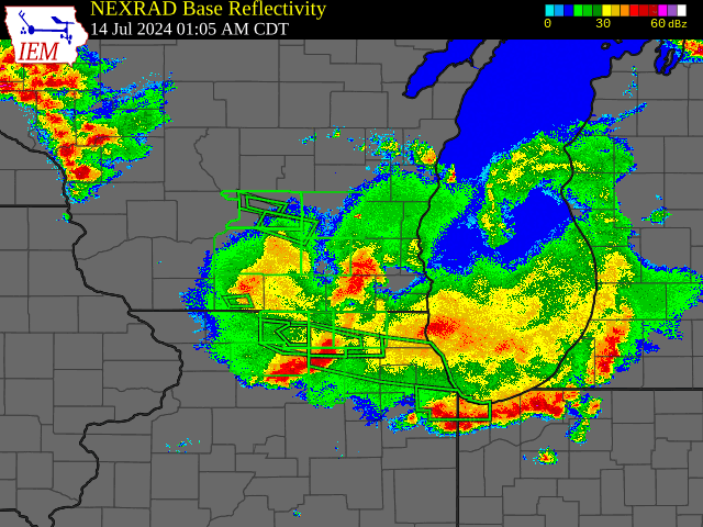
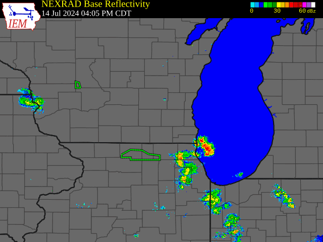
| Radar animation from the afternoon and evening of July 13, when a line of strong to severe storms tracked southeast across the area. | Radar animation from the predawn hours of July 14, when a second line of strong to severe storms approached the region from the northwest. | Radar animation from the afternoon and evening of July 14, when additional strong to severe storms tracked across the area. | Radar animation from the afternoon and evening of July 15, when an a derecho clipped the far southern edge of the Milwaukee/Sullivan county warning area. |
Storm Reports
Environment
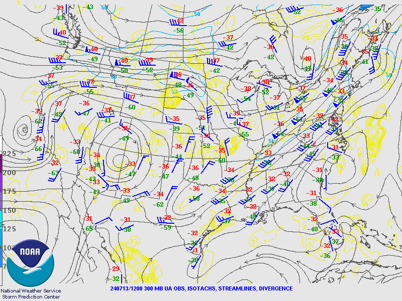
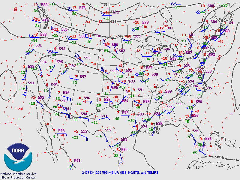
The mid to upper level pattern featured a pronounced area of high pressure centered over the Four Corners from July 13 to July 15 (figure 1). Such areas of mid to upper high pressure are not uncommon during the summer months, when they overlap with areas of very warm temperatures at the surface. These areas of high pressure can thus be commonly referred to as “heat domes” when they set up over areas of the country during the summer months. Areas located along the edges of these “heat domes” often see repeated rounds of thunderstorm activity, as disturbances pivot over the top and around their centers. This leads to the so-called “ring of fire” effect around the edges of summertime high pressure centers. Wisconsin’s placement along the northeast edge of the Four Corners upper high, combined with a series of mid-level shortwaves passing overhead (figure 2), placed our area within the “ring of fire” during the July 13th through 15th time period, helping to contribute to the multiple rounds of thunderstorms that occurred across the region. A surface front lingering across the northern Great Plains and western Great Lakes added additional support for thunderstorms, particularly during the final round of activity on July 15 (figure 3).
 |
 |
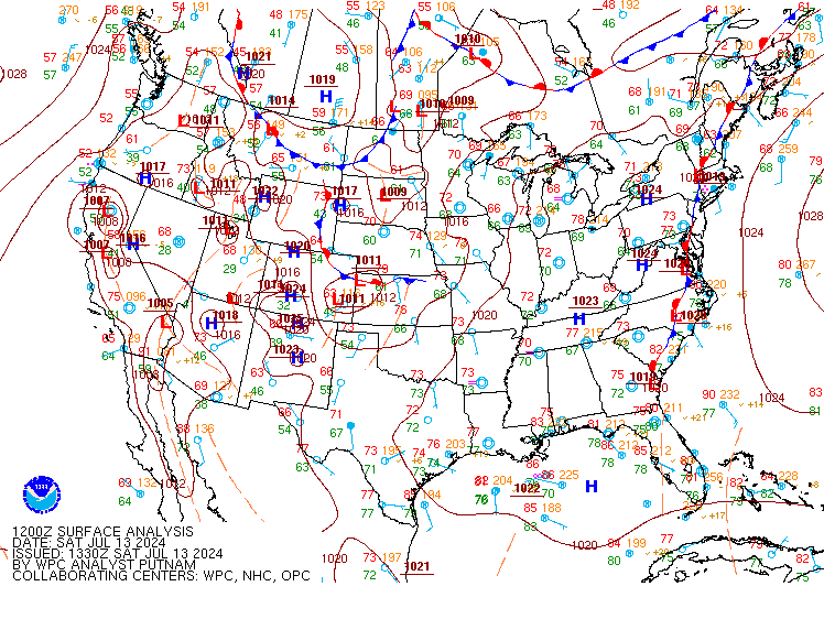 |
| Figure 1: 300 millibar (upper air) analyses between 12Z July 13 (7:00 AM CDT July 13) and 00Z July 16 (7:00 PM CDT July 15). Maps taken from the Storm Prediction Center upper air archive. | Figure 2: 500 mb (mid levels of the atmosphere) analyses between 12Z July 13 (7:00 AM CDT July 13) and 00Z July 16 (7:00 PM CDT July 15). Maps taken from the Storm Prediction Center upper air archive. | Figure 3: Surface analyses between 12Z July 13 (7:00 AM CDT July 13) and 00Z July 16 (7:00 PM CDT July 15). Surface maps taken from the Weather Prediction Center surface map archive. |
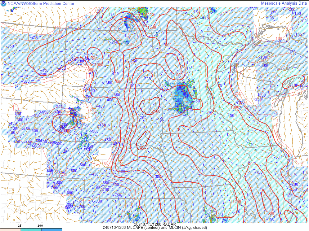
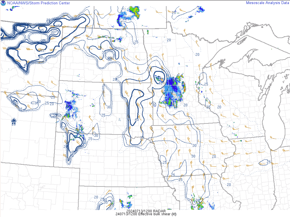
Despite the favorable large-scale setup for thunderstorms between July 13 and 15 across the state, additional ingredients were also in place to support the damaging winds, large hail, torrential downpours, and flooding that occurred within them. A very warm and muggy air mass was in place, allowing for large amounts of instability to build in during each afternoon period (figure 4). Such large amounts of instability helped to support the strong to severe storm development that occurred. Moderate to high amounts of wind shear—changes in wind speed and direction with height in the atmosphere—kept strong to severe storms organized during each afternoon period, allowing for large hail and damaging winds to occur over large swaths of the area (figure 5). Precipitable water values in the 1.5 to 2.0 inch range (figure 6) supported torrential rainfall within storms, resulting in multiple reports of flash flooding across the region.
 |
 |
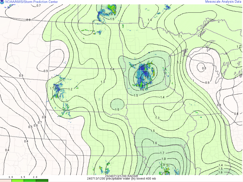 |
| Figure 4: Mixed layer CAPE (red lines) and CIN (blue colorfill) between 12Z July 13 (7:00 AM CDT July 13) and 00Z July 16 (7:00 PM CDT July 15). Images taken from the Storm Prediction Center mesoscale analysis archive. | Figure 5: Effective bulk shear magnitudes (blue lines) and vectors (tan wind barbs) between 12Z July 13 (7:00 AM CDT July 13) and 00Z July 16 (7:00 PM CDT July 15). Maps taken from the Storm Prediction Center mesoscale analysis archive. | Figure 6: Precipitable water values between 12Z July 13 (7:00 AM CDT July 13) and 00Z July 16 (7:00 PM CDT July 15). Maps taken from the Storm Prediction Center mesoscale analysis archive. |
 |
Media use of NWS Web News Stories is encouraged! Please acknowledge the NWS as the source of any news information accessed from this site. |
|

