Widespread, life-threatening considerable flash flooding is expected in south-central Texas through at least Friday. Catastrophic river flooding and rapid rises on small streams, arroyos, and typically dry washes are expected in the Texas Hill Country. Wildfire smoke is impacting air quality across much of the Great Lakes region into the Northeast U.S. with Air Quality Alerts in effect. Read More >
Overview
|
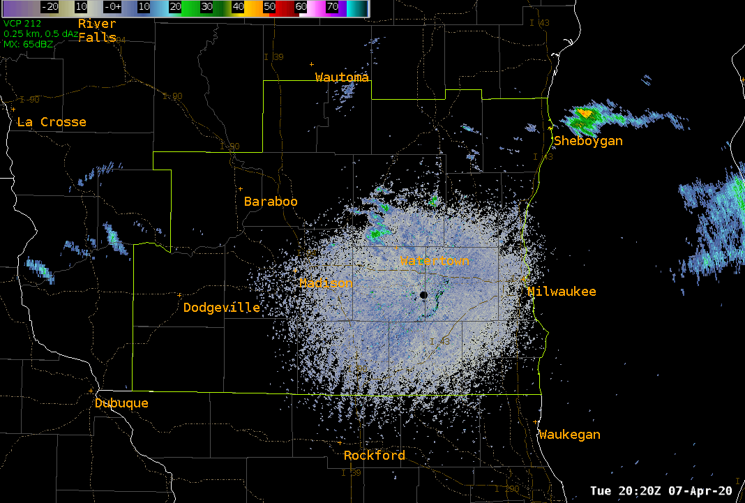
Several severe thunderstorms affected southeast and far south central Wisconsin Tuesday afternoon and early evening. The thunderstorms formed along a cold front which moved through southern Wisconsin. Ahead of the cold front, the atmosphere become warm and unstable. Temperatures rose into the 70s Tuesday afternoon as dewpoints neared 60. The severe thunderstorms deposited large hail just south and west of Monroe, and also in the Jackson, Cedarburg and Saukville areas. |
 Caption |
Hail:
Here are some pictures submitted through social media of the large hail that fell across southern Wisconsin late Tuesday afternoon and early evening. (Click for larger image)
.
 |
 |
 |
 |
|
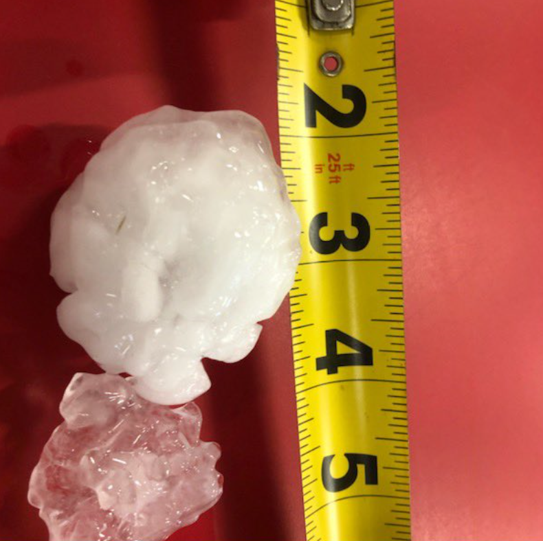
3" Hail in Browntown - Green County Picture by: Amy Wuethrich |
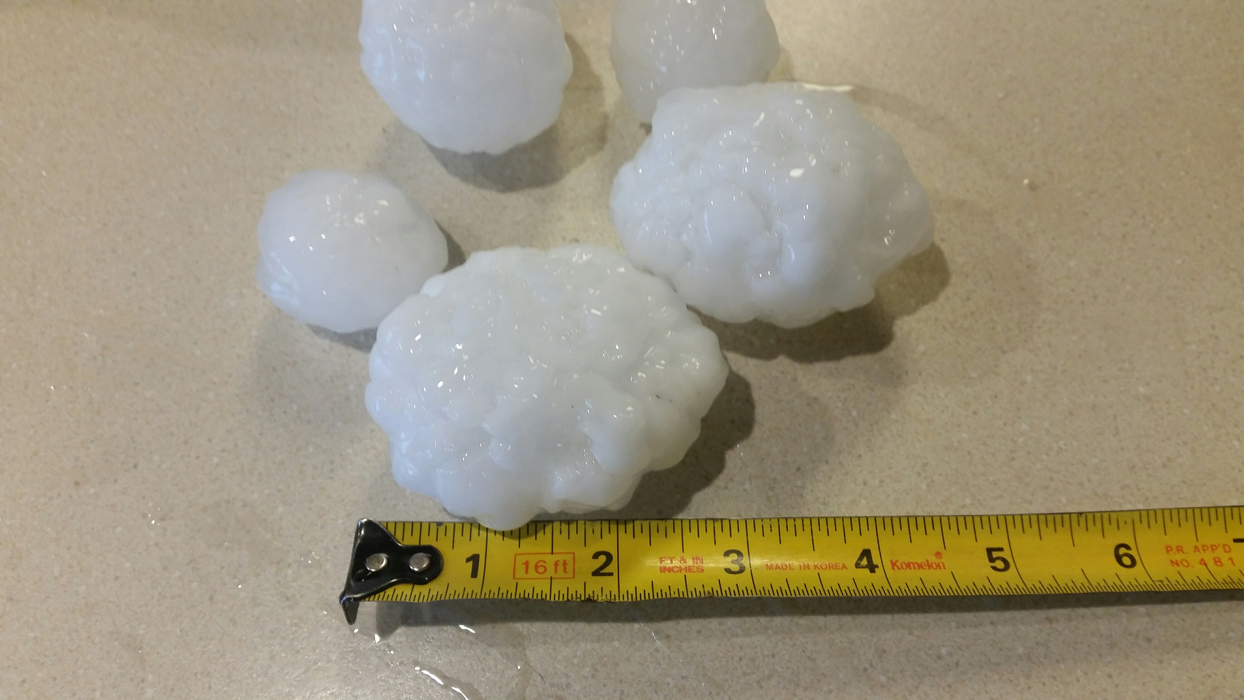
Egg Size Hail in Jackson - Washington County Picture by: Matt Schoeneck |
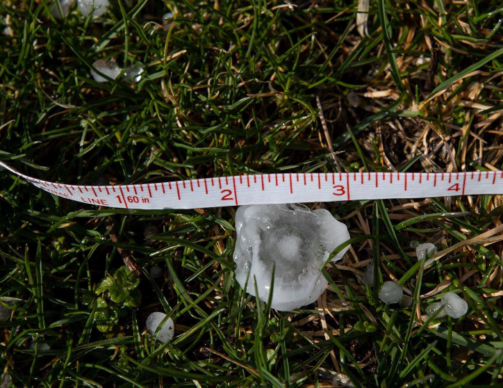
2.25" Hail in Cedarburg - Ozaukee County |
1" Hail in Saukville - Ozaukee County Picture by: Jeffery Phelps |
|
|
|||
|
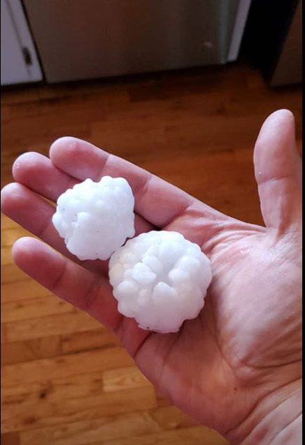
2" Hail in Jackson - Washington County Picture by: Alan Grahl |
Storm Reports
Here is a list of the Storm Reports that were reported to the National Weather Service office in Milwaukee:
PRELIMINARY LOCAL STORM REPORT...SUMMARY
NATIONAL WEATHER SERVICE MILWAUKEE/SULLIVAN WI
739 PM CDT TUE APR 7 2020

..TIME...   ...EVENT...      ...CITY LOCATION...     ...LAT.LON...
..DATE...   ....MAG....      ..COUNTY LOCATION..ST.. ...SOURCE....
            ..REMARKS..

0609 PM     HAIL             MONROE                  42.60N 89.64W
04/07/2020  E1.00 INCH       GREEN              WI   PUBLIC

            RELAYED FROM SOCIAL.

0607 PM     HAIL             1 S MONROE              42.58N 89.64W
04/07/2020  M1.75 INCH       GREEN              WI   PUBLIC

            RELAYED FROM SOCIAL MEDIA.

0604 PM     HAIL             4 SE BROWNTOWN          42.54N 89.73W
04/07/2020  M3.00 INCH       GREEN              WI   PUBLIC


0559 PM     HAIL             BROWNTOWN               42.58N 89.79W
04/07/2020  E1.00 INCH       GREEN              WI   LAW ENFORCEMENT

            SEVERE THUNDERSTORM IS STILL ONGOING.

0558 PM     HAIL             BROWNTOWN               42.58N 89.79W
04/07/2020  E1.75 INCH       GREEN              WI   PUBLIC

            RELAYED FROM SOCIAL MEDIA.

0554 PM     HAIL             SOUTH WAYNE             42.57N 89.88W
04/07/2020  E1.75 INCH       LAFAYETTE          WI   EMERGENCY MNGR


0540 PM     HAIL             WHITEFISH BAY           43.11N 87.90W
04/07/2020  E0.70 INCH       MILWAUKEE          WI   PUBLIC


0533 PM     HAIL             3 N WEST MILWAUKEE      43.05N 87.97W
04/07/2020  M0.50 INCH       MILWAUKEE          WI   PUBLIC

            REPORT FROM MPING: HALF-INCH (0.50 IN.).

0530 PM     HAIL             1 NW MILWAUKEE          43.06N 87.92W
04/07/2020  E1.00 INCH       MILWAUKEE          WI   PUBLIC

            RELAYED FROM SOCIAL MEDIA.

0528 PM     HAIL             GLENDALE                43.13N 87.93W
04/07/2020  M1.00 INCH       MILWAUKEE          WI   BROADCAST MEDIA

            RELAYED BY WTMJ.

0519 PM     HAIL             MENOMONEE FALLS         43.15N 88.13W
04/07/2020  M1.00 INCH       WAUKESHA           WI   PUBLIC


0501 PM     HAIL             5 S BELMONT             42.67N 90.33W
04/07/2020  M1.00 INCH       LAFAYETTE          WI   EMERGENCY MNGR


0422 PM     HAIL             1 NE GRAFTON            43.33N 87.93W
04/07/2020  M1.50 INCH       OZAUKEE            WI   PUBLIC


0416 PM     HAIL             4 E JACKSON             43.32N 88.08W
04/07/2020  M2.50 INCH       WASHINGTON         WI   PUBLIC

            FOUND ONE HAILSTONE MEASURING 2.5 INCHES,
            MOST WERE GOLF BALL SIZE.

0415 PM     HAIL             1 W PORT WASHINGTON     43.39N 87.89W
04/07/2020  U0.50 INCH       OZAUKEE            WI   PUBLIC

            REPORT FROM MPING: HALF-INCH (0.50 IN.).

0415 PM     HAIL             2 E GRAFTON             43.31N 87.92W
04/07/2020  M1.00 INCH       OZAUKEE            WI   TRAINED SPOTTER


0414 PM     HAIL             GRAFTON                 43.32N 87.96W
04/07/2020  M1.00 INCH       OZAUKEE            WI   PUBLIC

            REPORT FROM MPING: QUARTER (1.00 IN.).

0414 PM     HAIL             GRAFTON                 43.32N 87.95W
04/07/2020  M2.00 INCH       OZAUKEE            WI   PUBLIC


0412 PM     HAIL             1 E SAUKVILLE           43.38N 87.93W
04/07/2020  U0.75 INCH       OZAUKEE            WI   PUBLIC

            REPORT FROM MPING: DIME (0.75 IN.).

0411 PM     HAIL             1 NW CEDARBURG          43.31N 88.00W
04/07/2020  U1.25 INCH       OZAUKEE            WI   PUBLIC

            REPORT FROM MPING: HALF DOLLAR (1.25 IN.).

0408 PM     HAIL             CEDARBURG               43.30N 87.99W
04/07/2020  M1.75 INCH       OZAUKEE            WI   PUBLIC


0401 PM     HAIL             1 NW CEDARBURG          43.31N 88.00W
04/07/2020  U0.50 INCH       OZAUKEE            WI   PUBLIC

            REPORT FROM MPING: HALF-INCH (0.50 IN.).

0358 PM     HAIL             1 E SAUKVILLE           43.38N 87.93W
04/07/2020  U0.75 INCH       OZAUKEE            WI   PUBLIC

            REPORT FROM MPING: DIME (0.75 IN.).

0354 PM     HAIL             2 SE WEST BEND          43.40N 88.17W
04/07/2020  U0.50 INCH       WASHINGTON         WI   PUBLIC

            REPORT FROM MPING: HALF-INCH (0.50 IN.).

0353 PM     HAIL             2 SE WEST BEND          43.40N 88.17W
04/07/2020  U0.50 INCH       WASHINGTON         WI   PUBLIC

            REPORT FROM MPING: HALF-INCH (0.50 IN.).

0352 PM     HAIL             1 NNW JACKSON           43.34N 88.17W
04/07/2020  M2.50 INCH       WASHINGTON         WI   PUBLIC

            RELAYED VIA WTMJ.

0352 PM     HAIL             JACKSON                 43.32N 88.16W
04/07/2020  M1.75 INCH       WASHINGTON         WI   TRAINED SPOTTER


0351 PM     HAIL             2 SE WEST BEND          43.40N 88.17W
04/07/2020  U0.75 INCH       WASHINGTON         WI   PUBLIC

            REPORT FROM MPING: DIME (0.75 IN.).

0341 PM     HAIL             ALLENTON                43.42N 88.34W
04/07/2020  M1.00 INCH       WASHINGTON         WI   PUBLIC
&&
$$
 |
Media use of NWS Web News Stories is encouraged! Please acknowledge the NWS as the source of any news information accessed from this site. |
|