
Scattered severe storms capable of large to very large hail, severe wind gusts, and a few tornadoes will be possible across the central Plains this evening. Heavy to excessive rainfall may bring a flooding threat from the Great Lakes to the Mid-South through tonight. Hot, dry and windy conditions will continue to bring a critical fire weather threat from the Southwest into the Great Basin. Read More >
Overview
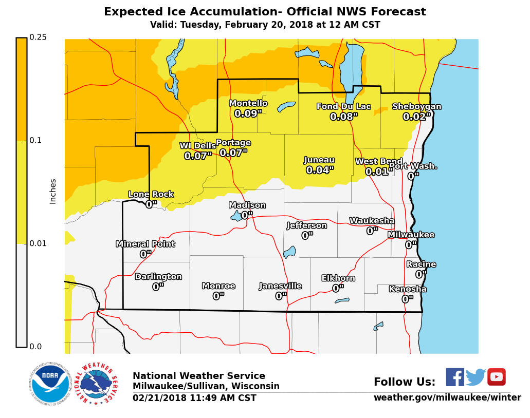
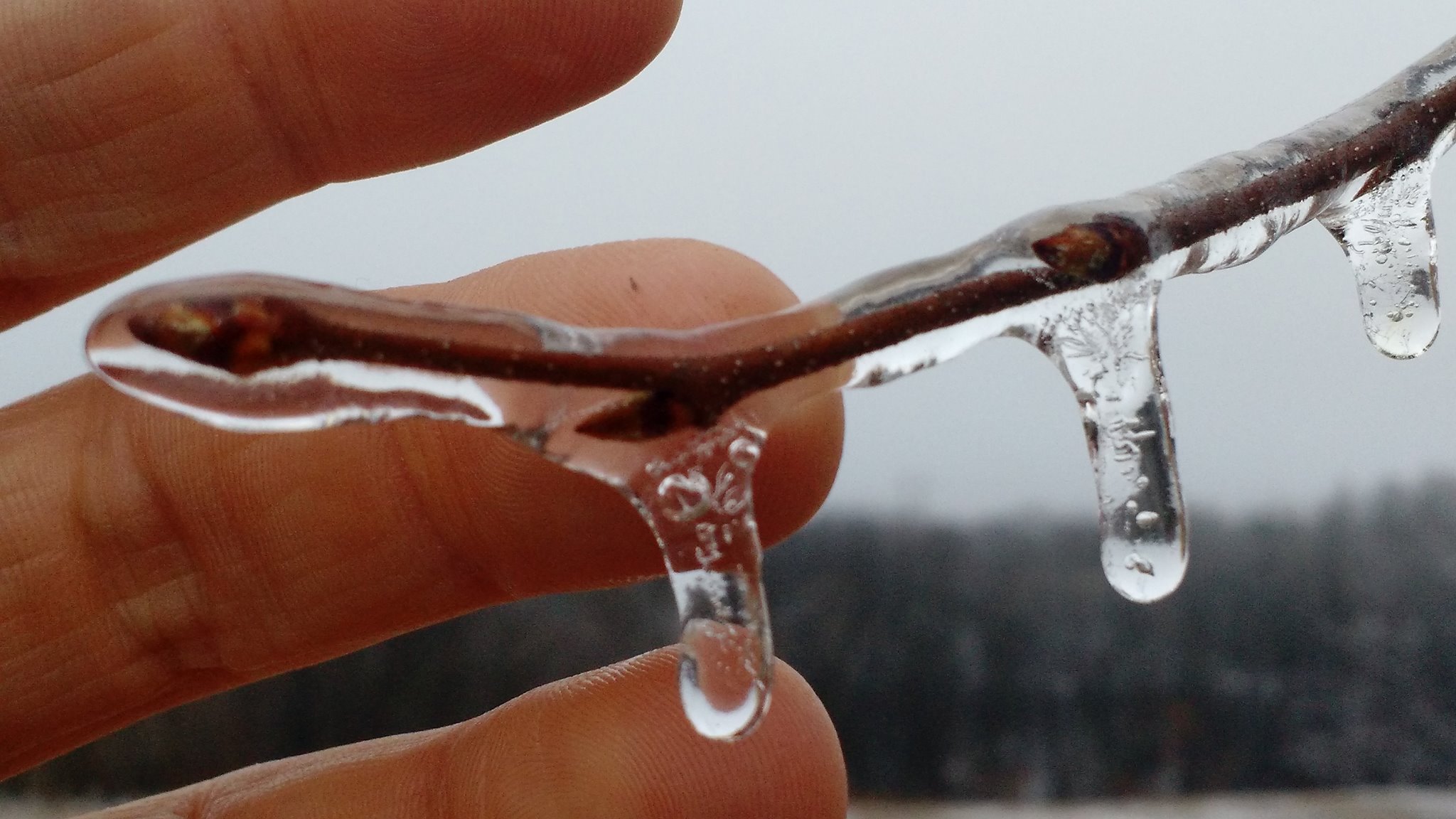
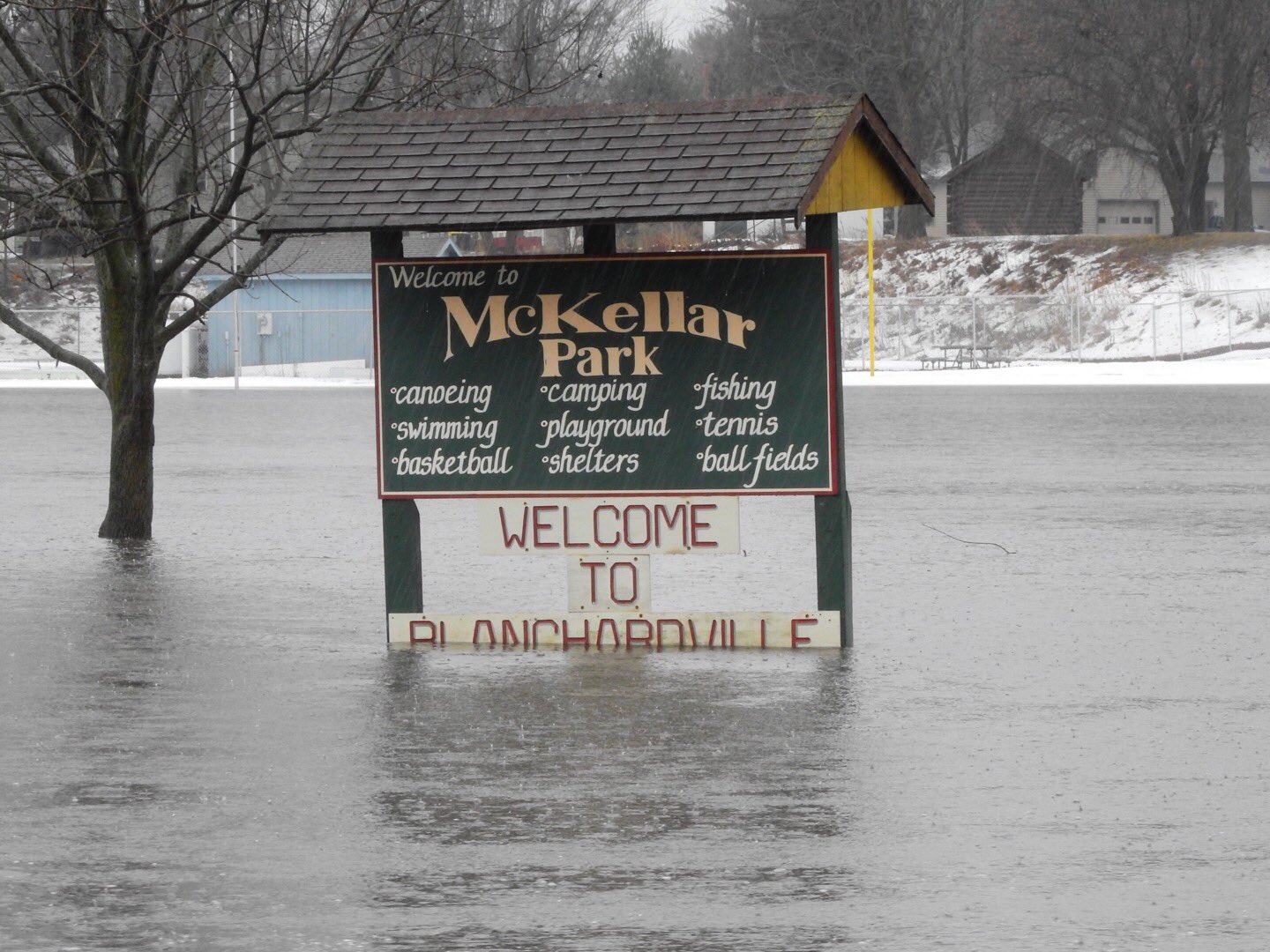
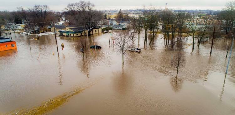
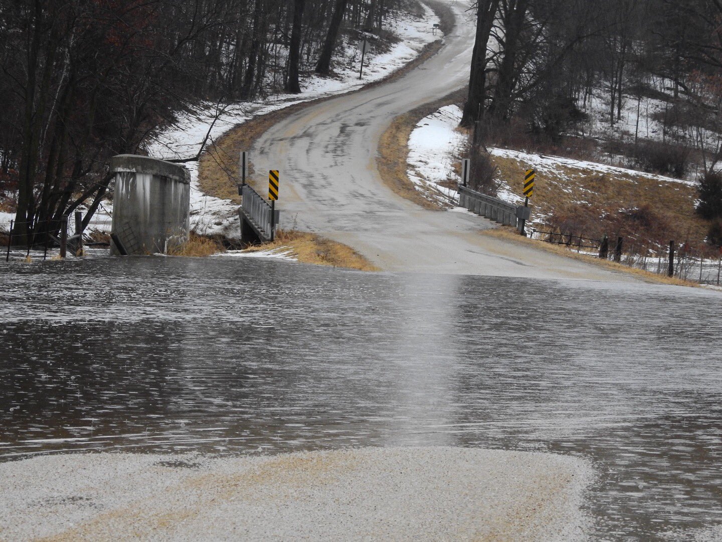
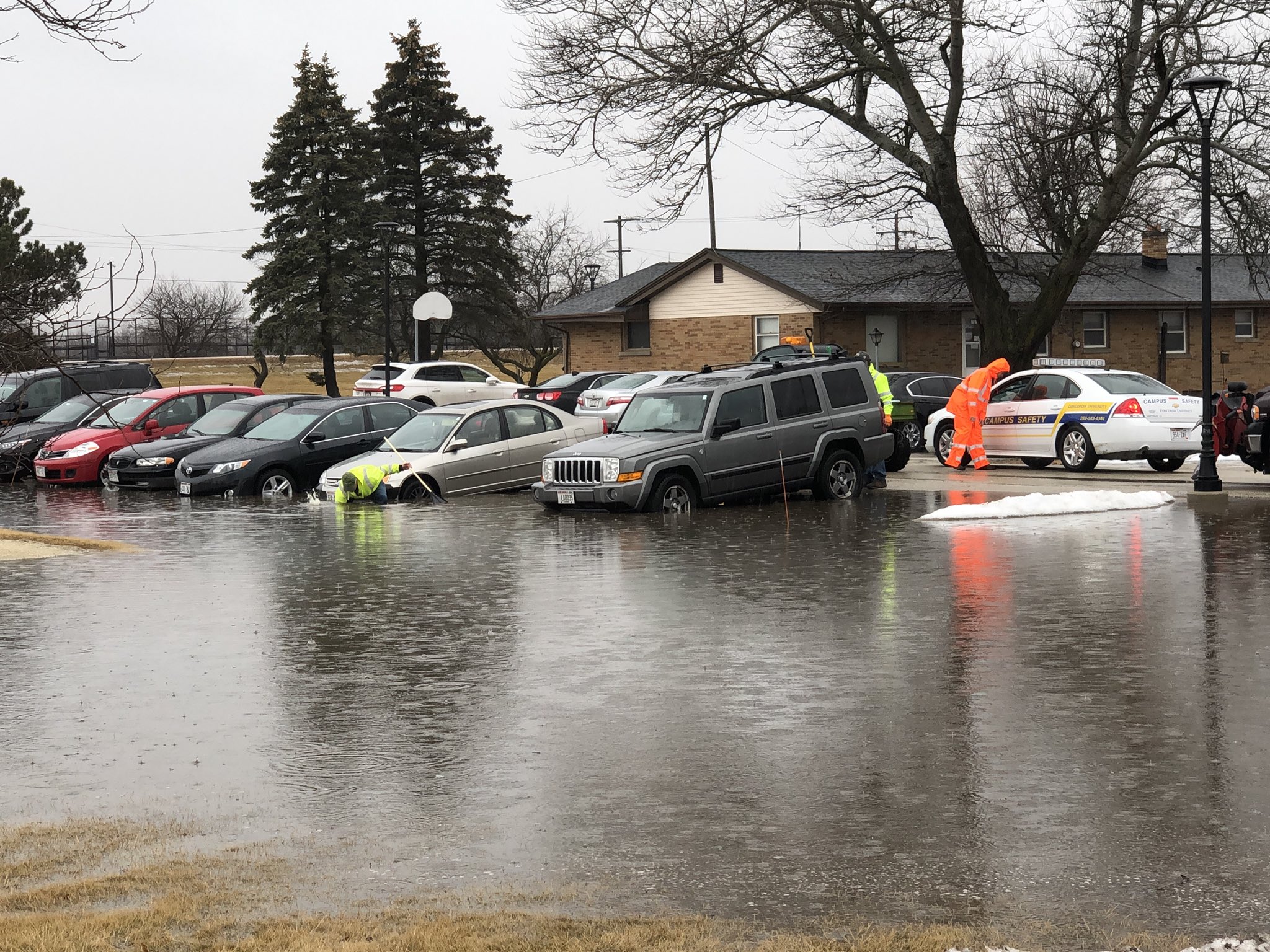
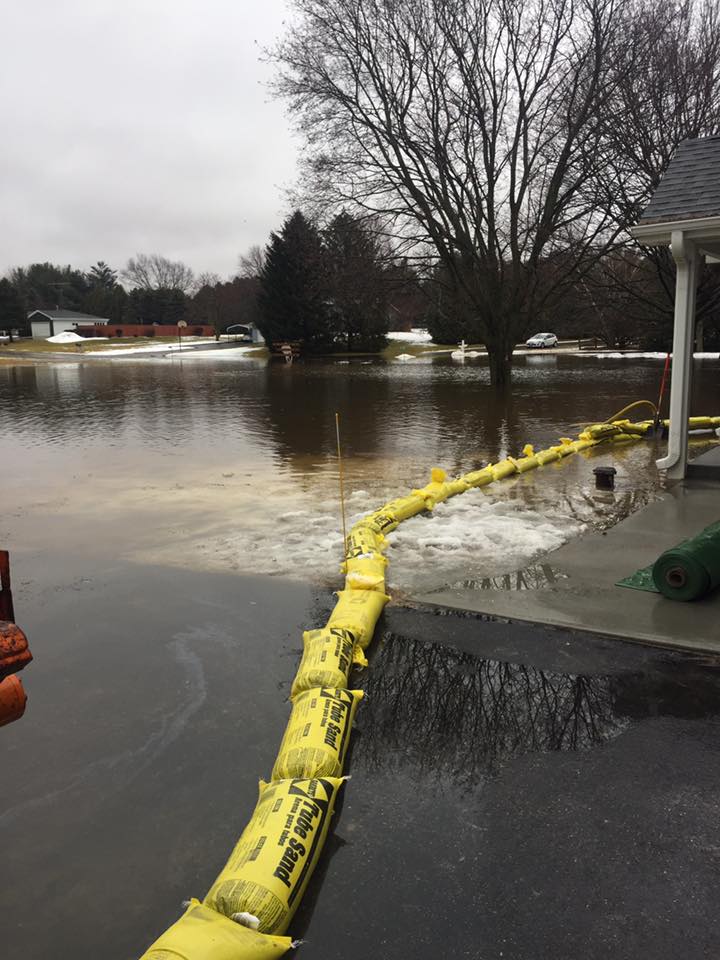
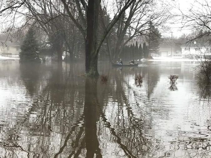
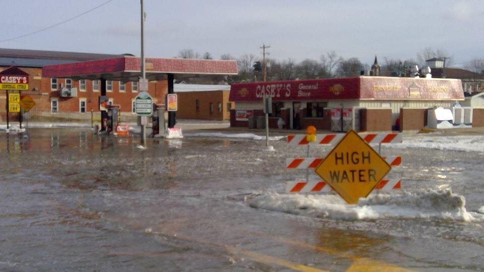
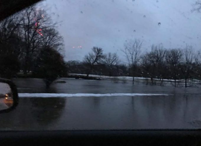
Moderate to heavy rainfall impacted southern Wisconsin evening Monday evening into Tuesday, with light icing towards central Wisconsin. The rain brought widespread flooding to portions of southern Wisconsin, as the water had very little place to go given the frozen ground. Area rivers swelled out of their banks as well, with some reaching moderate flood stage or higher. Slick stretches of roadway continued into Wednesday as temperatures dropped below freezing area-wide.Rain and Ice
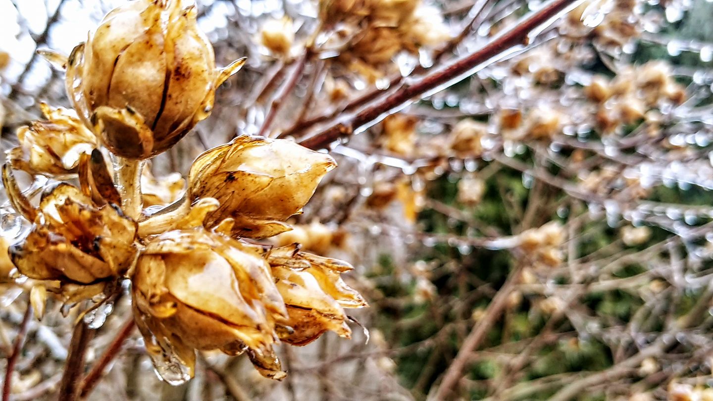
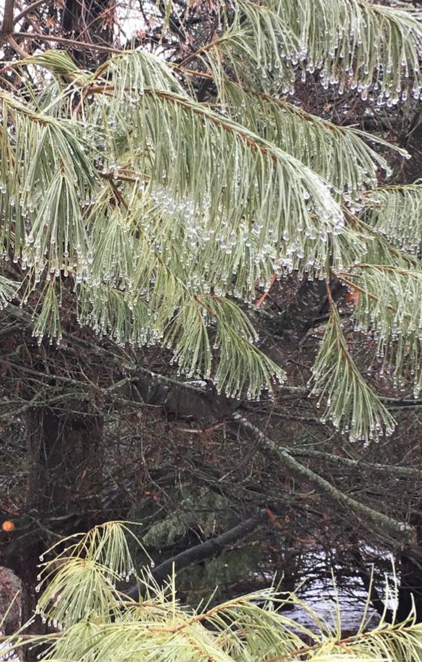
Photos:
Pictures from across southern Wisconsin of the ice and flooding.
 |
 |
|
 |
(Bradley Lloyd) |
Lomira (Russell Haug) |
Beaver Dam |
La Valle (J.a. Noll) |
 |
 |
 |
 |
| Blanchardville (John Kivikoski) |
Janesville (Andrew Sigwell) |
Waldwick (John Kivikoski) |
Mequon-Concordia Univ. (Benjaman Roob Jr) |
 |
 |
 |
 |
| Elkhorn (Crystal Jewell) |
Janesville (Savannah Robinson) |
Darlington (Jane Schemelia) |
Janesville (Brittanie Spude) |
Radar:
Loop of Thunderstorms in Evening to Heavy Snow Overnight
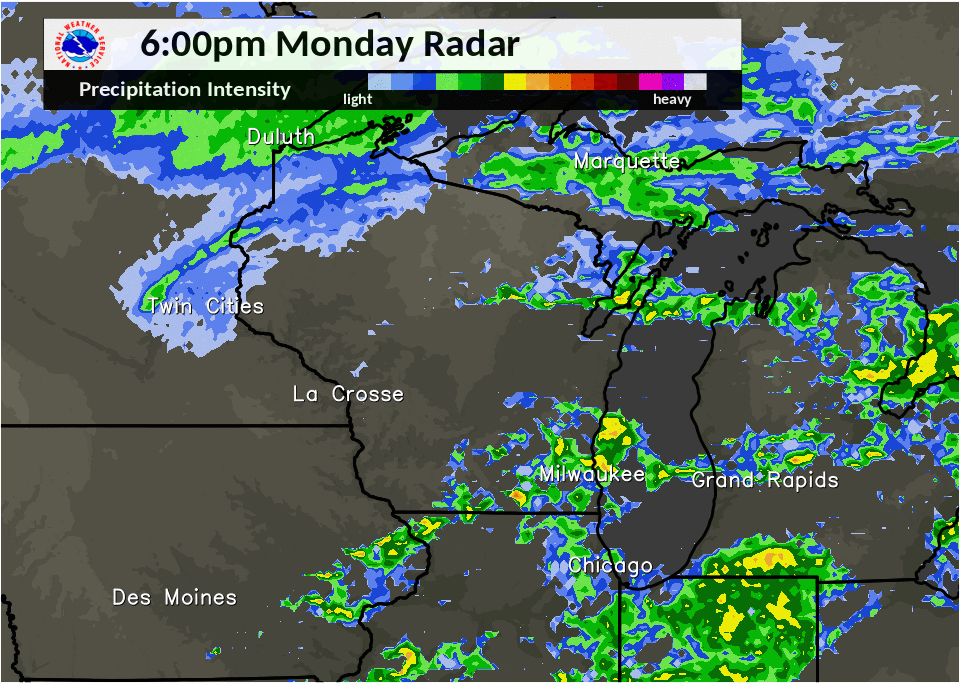 |
| Radar Loop: 6pm Monday until 6am Tuesday |
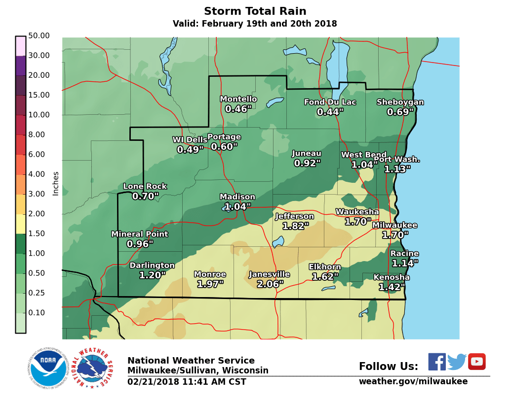
Rain Reports
Public Information Statement
National Weather Service Milwaukee/Sullivan WI
1010 AM CST Wed Feb 21 2018

...Storm Total Rainfall Reports - 2/19 through 2/21 2018...

Location                     Amount    Time/Date       Lat/Lon

...Wisconsin...

...Columbia County...
Arlington                    2.54 in   0945 AM 02/21   43.34N/89.39W
Portage                      1.44 in   0930 AM 02/21   43.54N/89.47W
Lodi                         0.88 in   0933 AM 02/21   43.31N/89.54W
1 S Columbus                 0.87 in   0700 AM 02/21   43.32N/89.03W
3 NE Lake Wisconsin          0.68 in   0700 AM 02/21   43.41N/89.53W
1 E Lake Wisconsin           0.66 in   0947 AM 02/21   43.38N/89.55W
5 NW Portage                 0.55 in   0932 AM 02/21   43.61N/89.54W
Univ Farm                    0.55 in   0800 AM 02/21   43.30N/89.35W
5 WSW Portage                0.52 in   0600 AM 02/21   43.51N/89.57W
Cambria                      0.40 in   0935 AM 02/21   43.54N/89.11W
1 NNW Pardeeville            0.32 in   0914 AM 02/21   43.56N/89.31W
Poynette                     0.28 in   0939 AM 02/21   43.39N/89.40W

...Dane County...
Brooklyn                     2.26 in   0700 AM 02/21   42.86N/89.36W
Stoughton                    2.03 in   0700 AM 02/21   42.92N/89.22W
Oregon                       1.83 in   0700 AM 02/21   42.92N/89.39W
1 ESE Shorewood Hills        1.48 in   0939 AM 02/21   43.07N/89.43W
Madison South-UW Arboretum   1.47 in   0728 AM 02/21   43.04N/89.43W
1 SSW Shorewood Hills        1.26 in   0700 AM 02/21   43.06N/89.46W
3 WSW Shorewood Hills        1.25 in   0730 AM 02/21   43.04N/89.51W
2 S Middleton                1.16 in   0700 AM 02/21   43.07N/89.51W
Mt Horeb                     1.15 in   0700 AM 02/21   42.98N/89.74W
1 SSW Middleton              1.14 in   0700 AM 02/21   43.08N/89.52W
1 SSW Sun Prairie            1.14 in   0940 AM 02/21   43.17N/89.24W
Madison                      1.07 in   0700 AM 02/21   43.06N/89.48W
Madison-Dane County Airport  1.04 in   0553 AM 02/21   43.14N/89.34W
Middleton                    1.02 in   0700 AM 02/21   43.09N/89.51W
Sun Prairie                  1.01 in   0945 AM 02/21   43.19N/89.22W
4 SW Black Earth             0.87 in   0937 AM 02/21   43.08N/89.78W
Black Earth                  0.83 in   0930 AM 02/21   43.13N/89.75W
2 NE Verona                  0.81 in   0938 AM 02/21   43.02N/89.50W
2 WSW Windsor                0.73 in   0926 AM 02/21   43.21N/89.38W
1 WNW Middleton              0.65 in   0555 AM 02/21   43.11N/89.53W
Cottage Grove                0.53 in   0700 AM 02/21   43.08N/89.19W

...Dodge County...
2 N Watertown                1.12 in   0929 AM 02/21   43.23N/88.73W
Beaver Dam                   0.68 in   0700 AM 02/21   43.45N/88.85W
3 NW Kekoskee                0.64 in   0928 AM 02/21   43.57N/88.61W
Dodge County Apt             0.61 in   0555 AM 02/21   43.43N/88.70W

...Fond du Lac County...
Fond Du Lac Airport          0.44 in   0553 AM 02/21   43.77N/88.49W
Fond Du Lac                  0.38 in   0700 AM 02/21   43.77N/88.47W
1 NNW Fond Du Lac            0.31 in   0900 AM 02/21   43.80N/88.46W

...Green County...
1 WSW Monroe                 2.28 in   0940 AM 02/21   42.59N/89.66W
2 SE Monticello              2.05 in   0700 AM 02/21   42.72N/89.56W
Brodhead                     1.96 in   0700 AM 02/21   42.62N/89.39W
New Glarus                   1.59 in   0700 AM 02/21   42.84N/89.62W

...Green Lake County...
Markesan                     0.51 in   0700 AM 02/21   43.70N/89.00W

...Iowa County...
5 SE Dodgeville              1.18 in   0700 AM 02/21   42.91N/90.06W
Mineral Point                1.07 in   0944 AM 02/21   42.85N/90.18W
4 N Dodgeville               0.92 in   0911 AM 02/21   43.02N/90.14W

...Jefferson County...
1 NW Whitewater              2.63 in   0700 AM 02/21   42.85N/88.75W
Whitewater                   2.22 in   0800 AM 02/21   42.86N/88.73W
1 N Palmyra                  2.05 in   0700 AM 02/21   42.90N/88.59W
Fort Atkinson                1.94 in   0700 AM 02/21   42.88N/88.83W
Jefferson-WWTP               1.83 in   0700 AM 02/21   42.99N/88.80W
Lake Mills                   1.63 in   0700 AM 02/21   43.07N/88.91W
Waterloo                     1.48 in   0929 AM 02/21   43.19N/88.99W
Watertown                    1.45 in   0700 AM 02/21   43.17N/88.74W

...Kenosha County...
1 NNE Lake Catherine         1.84 in   0929 AM 02/21   42.51N/88.11W
Kenosha-Airport              1.34 in   0553 AM 02/21   42.60N/87.93W
Kenosha-Water Pollution Cont 1.26 in   1200 AM 02/21   42.55N/87.81W
Pleasant Prairie             1.21 in   0600 AM 02/21   42.56N/87.94W
2 WSW Kenosha                1.16 in   0700 AM 02/21   42.56N/87.86W
1 NW Kenosha                 1.10 in   0948 AM 02/21   42.60N/87.83W
2 ENE Twin Lakes             0.94 in   0937 AM 02/21   42.53N/88.22W

...Lafayette County...
4 NNW South Wayne            2.09 in   0730 AM 02/21   42.63N/89.90W
Benton                       0.95 in   0545 AM 02/21   42.57N/90.39W
2 NW Council Hill            0.49 in   0930 AM 02/21   42.51N/90.38W

...Marquette County...
4 E Oxford                   0.40 in   0914 AM 02/21   43.79N/89.48W
Montello                     0.39 in   0700 AM 02/21   43.78N/89.30W
Neshkoro                     0.34 in   0700 AM 02/21   43.96N/89.22W

...Milwaukee County...
1 N West Milwaukee           2.72 in   0940 AM 02/21   43.03N/87.97W
2 NE West Allis              2.64 in   0939 AM 02/21   43.03N/88.01W
West Allis                   2.11 in   0800 AM 02/21   43.00N/88.02W
South Milwaukee-WWTP         2.00 in   0700 AM 02/21   42.90N/87.85W
Franklin 2 NW                1.94 in   0700 AM 02/21   42.92N/88.06W
1 ENE Greendale              1.87 in   0700 AM 02/21   42.94N/87.98W
1 E Glendale                 1.84 in   0940 AM 02/21   43.13N/87.91W
Milwaukee-Gen Mitchell Arpt  1.70 in   0552 AM 02/21   42.95N/87.90W
2 ENE Franklin               1.62 in   0700 AM 02/21   42.90N/87.97W
Oak Creek                    1.55 in   0943 AM 02/21   42.90N/87.90W
1 NNW Saint Francis          1.49 in   0943 AM 02/21   42.99N/87.88W
1 S West Allis               1.48 in   0932 AM 02/21   42.98N/88.03W
1 E Wauwatosa                1.47 in   0700 AM 02/21   43.06N/88.00W
3 WSW Glendale               1.41 in   0700 AM 02/21   43.11N/87.99W
Mt. Mary College             1.39 in   0700 AM 02/21   43.07N/88.03W
1 SW Glendale                1.38 in   0945 AM 02/21   43.12N/87.94W
Milwaukee-Timmerman Arpt     1.27 in   0700 AM 02/21   43.11N/88.03W
Brown Deer                   1.19 in   0941 AM 02/21   43.17N/87.99W
1 ESE Saint Francis          0.77 in   0944 AM 02/21   42.96N/87.85W

...Ozaukee County...
Port Washington              2.36 in   0939 AM 02/21   43.40N/87.88W
Grafton                      1.96 in   0940 AM 02/21   43.32N/87.96W
3 W Cedarburg                1.44 in   0941 AM 02/21   43.29N/88.06W
Belgium-WWTP                 1.30 in   0700 AM 02/21   43.51N/87.85W
Saukville-WWTP               1.14 in   0600 AM 02/21   43.37N/87.94W

...Racine County...
3 S Oak Creek                1.84 in   0930 AM 02/21   42.83N/87.89W
Elmwood Park                 1.52 in   0940 AM 02/21   42.70N/87.81W
Racine                       1.40 in   0940 AM 02/21   42.72N/87.80W
Union Grove                  1.38 in   0700 AM 02/21   42.70N/88.03W
Rochester-WWTP               1.36 in   0600 AM 02/21   42.73N/88.23W
1 NW Elmwood Park            1.34 in   0700 AM 02/21   42.71N/87.85W
1 NNW Racine                 1.31 in   0700 AM 02/21   42.75N/87.79W
1 NW Wind Point              1.14 in   0944 AM 02/21   42.80N/87.79W
4 N Union Grove              1.08 in   0942 AM 02/21   42.75N/88.04W
Burlington                   0.76 in   0555 AM 02/21   42.69N/88.31W
Racine-Batten Airport        0.47 in   0553 AM 02/21   42.76N/87.81W

...Rock County...
2 E Janesville               2.64 in   0800 AM 02/21   42.69N/88.96W
3 W Janesville               2.46 in   0700 AM 02/21   42.68N/89.08W
Milton-WWTP                  2.44 in   0700 AM 02/21   42.78N/88.94W
3 S Edgerton                 2.00 in   0943 AM 02/21   42.79N/89.07W
2 W Beloit                   1.72 in   0940 AM 02/21   42.52N/89.07W
Beloit                       1.54 in   0540 AM 02/21   42.50N/89.03W
2 NNW Clinton                1.39 in   0700 AM 02/21   42.60N/88.88W

...Sauk County...
Sauk City                    0.75 in   0608 AM 02/21   43.26N/89.74W
Lone Rock-Airport            0.70 in   0556 AM 02/21   43.21N/90.19W
Baraboo-WWTP                 0.54 in   0726 AM 02/21   43.48N/89.63W
1 SSE Lake Delton            0.48 in   0929 AM 02/21   43.57N/89.77W
2 WSW Rock Springs           0.45 in   0700 AM 02/21   43.46N/89.97W
1 NE Baraboo                 0.44 in   0930 AM 02/21   43.49N/89.72W
Reedsburg 1nne               0.41 in   0515 AM 02/21   43.55N/90.00W
Reedsburg                    0.33 in   0800 AM 02/21   43.52N/90.00W
Reedsburg-Airport            0.32 in   0555 AM 02/21   43.53N/89.98W
Baraboo                      0.22 in   0555 AM 02/21   43.52N/89.77W

...Sheboygan County...
Random Lake                  1.00 in   0940 AM 02/21   43.55N/87.95W
Random Lake-CoCoRaHS         0.96 in   0700 AM 02/21   43.55N/87.95W
3 NNE Kohler                 0.76 in   0630 AM 02/21   43.78N/87.77W
2 NNW Sheboygan              0.76 in   0940 AM 02/21   43.78N/87.72W
Sheboygan-Airport            0.69 in   0553 AM 02/21   43.77N/87.85W
Howards Grove                0.55 in   0700 AM 02/21   43.84N/87.82W
Plymouth                     0.53 in   0932 AM 02/21   43.75N/87.97W
Millhome 1 ESE               0.40 in   0939 AM 02/21   43.89N/87.94W

...Walworth County...
East Troy 2.5 NNE            1.77 in   0700 AM 02/21   42.82N/88.38W
Lake Geneva                  1.54 in   0700 AM 02/21   42.59N/88.42W
Elkhorn                      1.51 in   0530 AM 02/21   42.67N/88.53W
2 SW Delavan Lake            1.45 in   0645 AM 02/21   42.58N/88.65W
Genoa City                   1.19 in   0943 AM 02/21   42.50N/88.32W

...Washington County...
2 E Jackson                  2.60 in   0939 AM 02/21   43.31N/88.12W
1 N Jackson                  1.82 in   0700 AM 02/21   43.35N/88.16W
Jackson                      1.82 in   0700 AM 02/21   43.35N/88.16W
3 SSW Richrield              1.78 in   0600 AM 02/21   43.21N/88.21W
1 ESE Hartford               1.51 in   0700 AM 02/21   43.31N/88.36W
2 W Hartford                 1.51 in   0630 AM 02/21   43.32N/88.40W
4 NE Jackson                 1.51 in   0800 AM 02/21   43.37N/88.10W
3 ESE Jackson                1.39 in   0500 AM 02/21   43.29N/88.11W
Slinger                      1.35 in   0700 AM 02/21   43.33N/88.30W
Germantown                   1.34 in   0600 AM 02/21   43.23N/88.10W
West Bend                    1.28 in   0940 AM 02/21   43.42N/88.19W
West Bend-Public Works       1.27 in   0846 AM 02/21   43.41N/88.19W
1 NW West Bend               1.15 in   0534 AM 02/21   43.44N/88.20W
1 W Kewaskum                 1.02 in   0700 AM 02/21   43.53N/88.27W
4 WNW West Bend              1.02 in   0941 AM 02/21   43.45N/88.26W
1 ESE West Bend              0.74 in   0944 AM 02/21   43.41N/88.15W

...Waukesha County...
2 SE Eagle                   2.42 in   0700 AM 02/21   42.85N/88.44W
1 N Muskego                  2.40 in   0939 AM 02/21   42.91N/88.12W
Mukwonago                    2.27 in   0700 AM 02/21   42.87N/88.33W
1 WNW New Berlin             2.11 in   0700 AM 02/21   42.98N/88.16W
1 NW Waukesha                2.02 in   0845 AM 02/21   43.03N/88.26W
Dousman                      1.96 in   0939 AM 02/21   43.01N/88.47W
1 E Mukwonago                1.92 in   0700 AM 02/21   42.87N/88.30W
Delafield                    1.63 in   0942 AM 02/21   43.07N/88.40W
2 SSE Wales                  1.61 in   0857 AM 02/21   42.97N/88.36W
Oconomowoc                   1.57 in   0700 AM 02/21   43.11N/88.50W
2 NW Hales Corners           1.50 in   0940 AM 02/21   42.97N/88.07W
Elm Grove                    1.40 in   0939 AM 02/21   43.05N/88.08W
Okauchee Lake                1.01 in   0949 AM 02/21   43.11N/88.44W
Muskego                      0.81 in   0947 AM 02/21   42.89N/88.14W
Brookfield                   0.65 in   0943 AM 02/21   43.06N/88.14W
Brookfield                   0.63 in   0928 AM 02/21   43.06N/88.14W

Observations are collected from a variety of sources with varying
equipment and exposures. We thank all volunteer weather observers
for their dedication. Not all data listed are considered official.
 |
Media use of NWS Web News Stories is encouraged! Please acknowledge the NWS as the source of any news information accessed from this site. |
|

