
A wet Memorial Day weekend is in store for the East, with widespread rainfall of 1 to more than 2 inches expected from the Gulf Coast to southern New England. Well above normal temperatures are forecast to build across the northern Plains. Another round of heavy to excessive rainfall is expected to impact the western Gulf Coast this weekend with Flood Watches in effect. Read More >
Milwaukee/Sullivan, WI
Weather Forecast Office
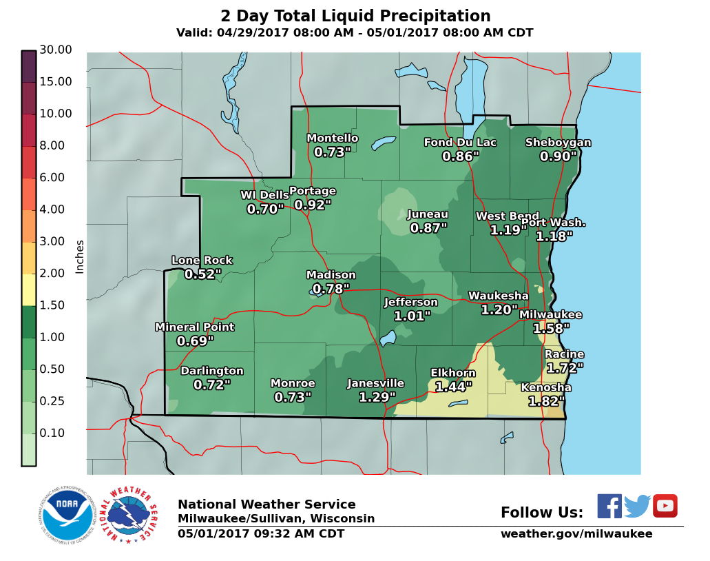
Rainfall over the past weekend amounted to between three quarters inch around the Wisconsin Dells, to just under two inches around Racine and Kenosha.
The below graphic illustrates the past weekend's rainfall:
The rainfall will continue to result in many southern Wisconsin rivers rising to above bankfull stage, or remaining above bankfull stage through the coming week. A few rivers, including the Fox River in western Racine and Kenosha counties, and the Rock River at Afton, will reach minor flood stage.
Here is a map showing the current stages for rivers in our area. You may click on a point to get additional information:
Here is the latest hydrograph for the Fox River near New Munster:
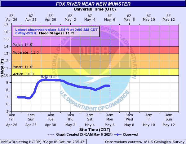
Many river levels will remain elevated through this week.
Monitor these rivers by using the Advanced Hydrologic Prediction Services (AHPS) website, which contains current and forecast river stage information for many rivers across southern Wisconsin.
Here are the latest local and regional radar loops:
| Local Radar | Regional Radar - West View |
Regional Radar - East View |
 |
 |
 |
Here is our latest Hazardous Weather Outlook.
Wood/Kavinsky/SPM
NWS Milwaukee/Sullivan, WI
Hazards
National Briefing
Hazardous Weather Outlook
Skywarn
View Local Storm Reports
Submit A Storm Report
Winter Weather
Summer Weather
Beach Hazards
Local Forecasts
Marine
Aviation
Fire
Local Text Products
Local Precip Forecast
Hourly Forecast Graphics
Forecast Discussion
Climate
Historic Events For Srn WI
Lightning Plot Archive
Daily Climate Graphics
Local Climate Products
Normals/Records MKE/MSN
CoCoRaHS
US Dept of Commerce
National Oceanic and Atmospheric Administration
National Weather Service
Milwaukee/Sullivan, WI
N3533 Hardscrabble Road
Dousman, WI 53118
262-965-2074
Comments? Questions? Please Contact Us.

