
Dangerous heat will expand from the Gulf Coast into the Southern Plains and Desert Southwest through week's end. Additional extreme heat impacting the Pacific Northwest will shift to the northern Plains by the weekend. Tropical Storm Bertha is expected to continue to impact portions of the northern Gulf Coast from the western Florida Panhandle to southeastern Louisiana through tonight. Read More >
Overview
|
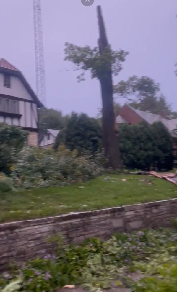
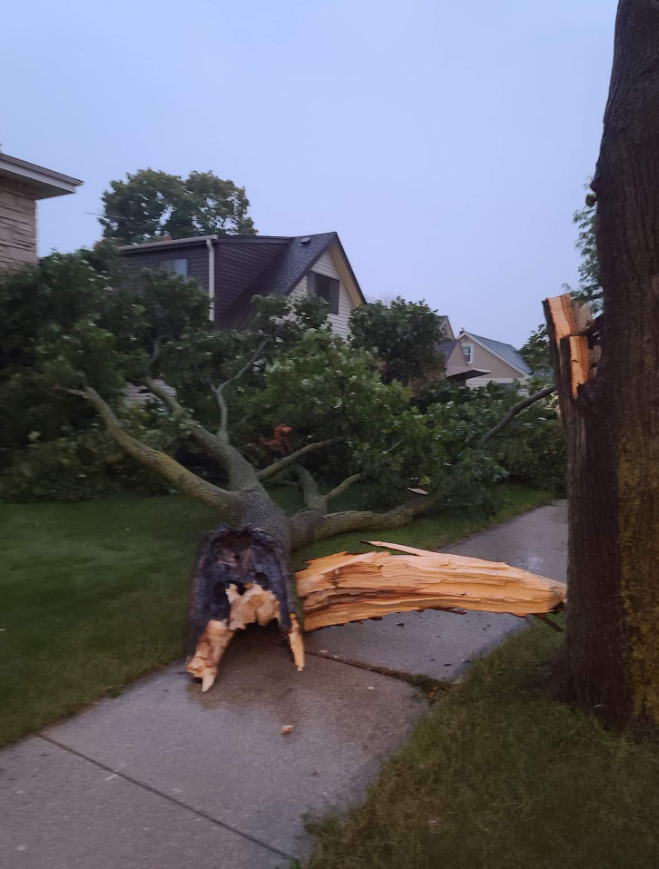
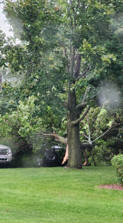
Damaging winds and small hail resulted from a cluster of thunderstorms that organized into a line and tracked through central and southeast Wisconsin early Sunday evening. The storms formed along the leading edge of an upper level disturbance. They ended up being stronger than expected because there were large breaks in the clouds during the afternoon. This helped to warm the temperatures and allow for greater instability. Wind gusts up to 60 mph knocked down branches, trees and power lines across portions of east central and southeast Wisconsin between 4 and 7 pm. There were a few reports of small hail as well. |
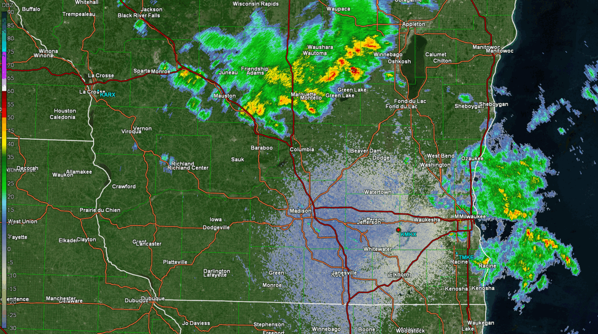 KMKX Radar Reflectivity 4:30 to 7:20 PM CDT |
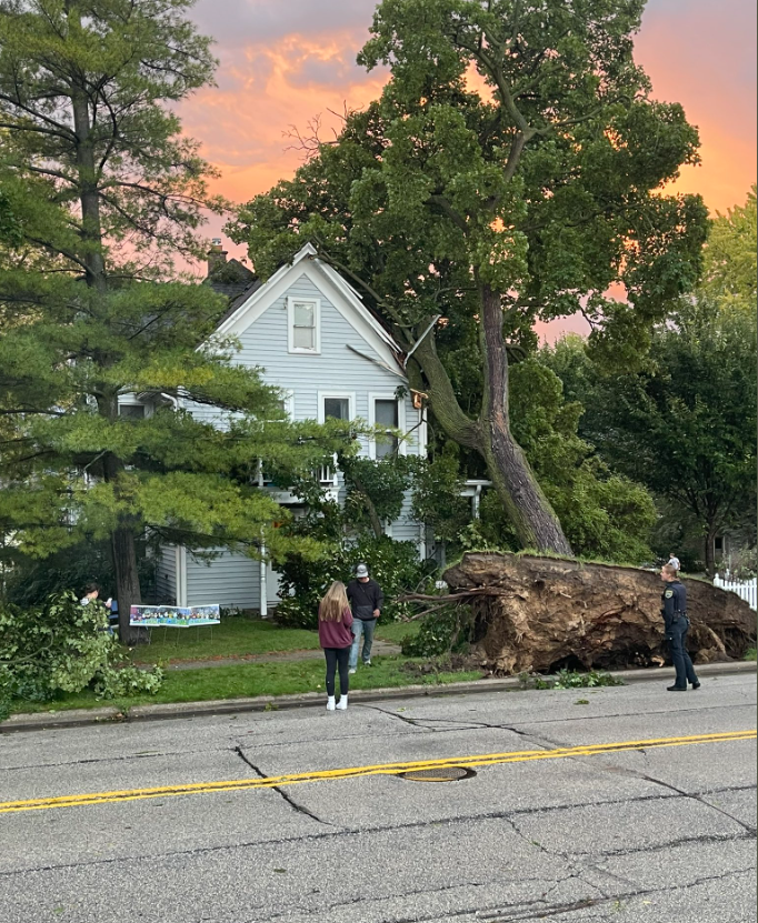
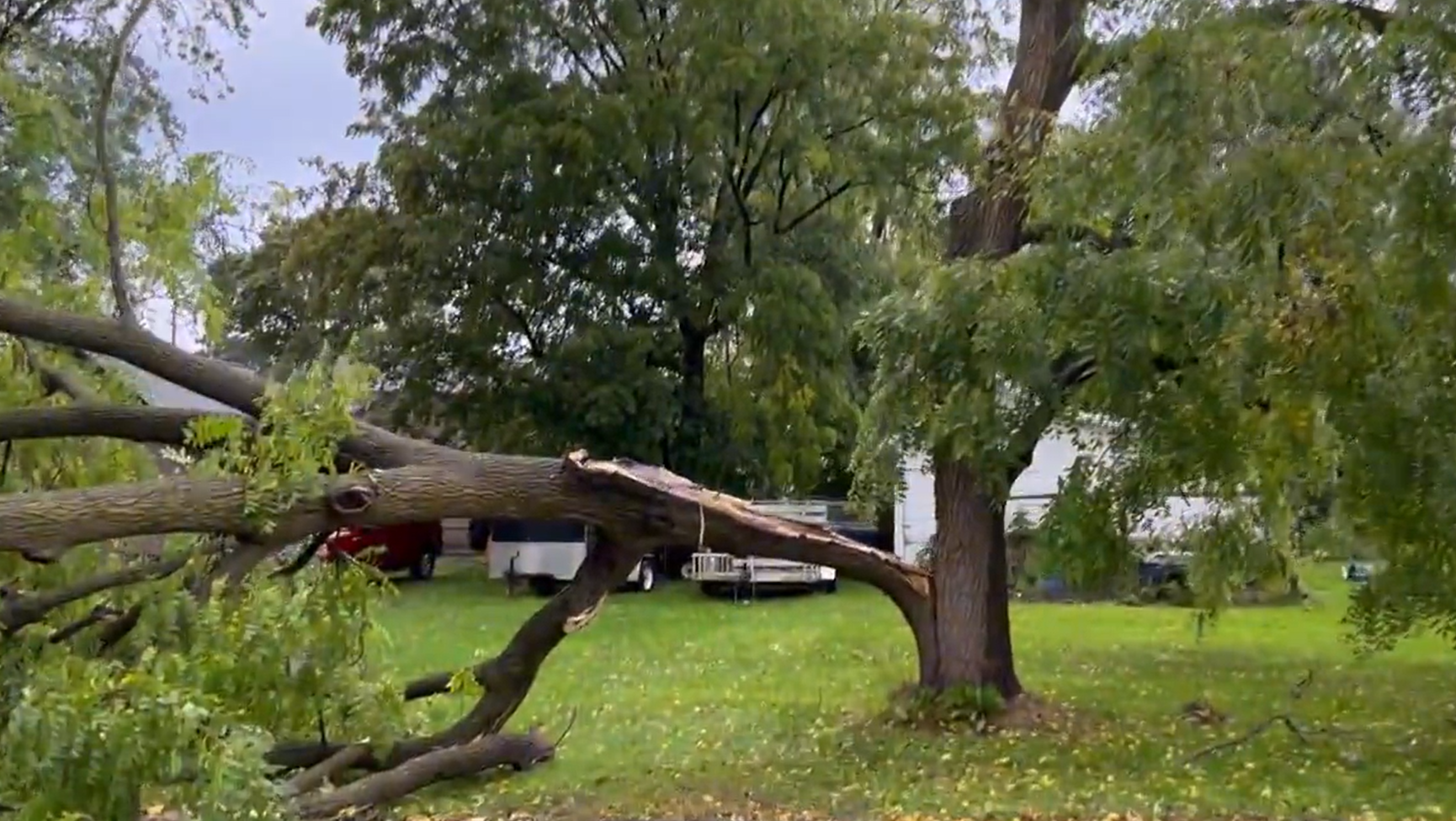
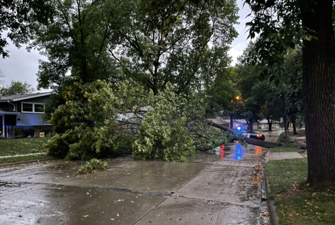
Photos:
.PNG) |
 |
 |
 |
|
Arlington Photo credit: @amorganwx & Grand Moxon, Twitter |
West Bend Photo credit: @metromkewx, Twitter |
Campbellsport Photo credit: @CBS58, Twitter |
Waukesha Photo credit: @StormChaser_CJ, Twitter |
 |
 |
.PNG) |
 |
|
Wauwatosa Photo credit: @Bamax666, Twitter |
Milwaukee Photo credit: Justin Paul, Facebook |
Bayview Photo credit: @SamKuffelWx, Alec Jacobson, Twitter |
East Troy Photo credit: @alainaford, Twitter |
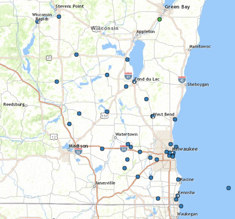
Storm Reports
..TIME...   ...EVENT...      ...CITY LOCATION...     ...LAT.LON...
..DATE...   ....MAG....      ..COUNTY LOCATION..ST.. ...SOURCE....
            ..REMARKS..

0730 PM     MARINE TSTM WIND 35 E RACINE             42.67N 87.10W
09/25/2022  M56 MPH          LMZ675             WI   BUOY

            SUSTAINED WINDS OF 40 MPH WITH GUSTS TO 56
            MPH AT BUOY 45007, SOUTH MICHIGAN.
0705 PM     TSTM WND DMG     KENOSHA                 42.59N 87.83W
09/25/2022                   KENOSHA            WI   911 CALL CENTER

            DELAYED REPORT OF TREES DOWN AND TREE LIMBS
            ON POWERLINES IN KENOSHA. TIME ESTIMATED
            FROM RADAR.
0705 PM     TSTM WND DMG     2 S MILWAUKEE           43.01N 87.90W
09/25/2022                   MILWAUKEE          WI   PUBLIC

            REPORT FROM MPING: 1-INCH TREE LIMBS BROKEN;
            SHINGLES BLOWN OFF.

0705 PM     TSTM WND GST     3 SW KENOSHA            42.55N 87.85W
09/25/2022  M52 MPH          KENOSHA            WI   PUBLIC

            MEASURED 52 MPH GUST ON WEATHER STATION AT
            HOME. TIME RADAR ESTIMATED.

0655 PM     TSTM WND GST     BATTEN INTERNATIONAL AI 42.76N 87.82W
09/25/2022  M40 MPH          RACINE             WI   ASOS

            DELAYED REPORT NEAR LAKE MICHIGAN AT RACINE
            AIRPORT.

0655 PM     TSTM WND GST     BATTEN INTERNATIONAL AI 42.76N 87.82W
09/25/2022  M40 MPH          RACINE             WI   ASOS

            DELAYED REPORT NEAR LAKE MICHIGAN AT RACINE
            AIRPORT.
0649 PM     TSTM WND DMG     1 SSW PADDOCK LAKE      42.56N 88.11W
09/25/2022                   KENOSHA            WI   911 CALL CENTER

            DELAYED REPORT OF TREES DOWN IN SALEM. TIME
            ESTIMATED FROM RADAR.
0637 PM     TSTM WND DMG     1 SSE WATERFORD NORTH   42.78N 88.21W
09/25/2022                   RACINE             WI   911 CALL CENTER

            DELAYED REPORTS OF MULTIPLE TREES DOWN AND
            TREES ON POWERS LINES ACROSS WESTERN RACINE
            COUNTY. TIME ESTIMATED FROM RADAR.

0635 PM     TSTM WND DMG     EAST TROY               42.79N 88.40W
09/25/2022                   WALWORTH           WI   LAW ENFORCEMENT

            REPORTS OF NUMEROUS TREES AND POWERLINES
            DOWNED IN THE EAST TROY.

0634 PM     TSTM WND DMG     1 SW LAC LA BELLE       43.13N 88.54W
09/25/2022                   JEFFERSON          WI   PUBLIC

            REPORT FROM MPING: 3-INCH TREE LIMBS BROKEN;
            POWER POLES BROKEN.

0632 PM     TSTM WND DMG     GLENDALE                43.13N 87.93W
09/25/2022                   MILWAUKEE          WI   BROADCAST MEDIA

            LARGE TREE LIMBS DOWN.

0630 PM     TSTM WND DMG     1 ESE WEST MILWAUKEE    43.01N 87.95W
09/25/2022                   MILWAUKEE          WI   PUBLIC

            DOWN TREE ON TOP OF A CAR ON MILWAUKEE
            SOUTHSIDE. TIME RADAR ESTIMATED.

0630 PM     MARINE TSTM WIND 1 ENE MILWAUKEE         43.04N 87.89W
09/25/2022  M45 MPH          LMZ645             WI   C-MAN STATION


0630 PM     MARINE TSTM WIND 2 ENE SHOREWOOD         43.10N 87.85W
09/25/2022  M40 MPH          LMZ644             WI   BUOY

            CORRECTS PREVIOUS MARINE TSTM WIND REPORT
            FROM 2 ENE SHOREWOOD. CORRECTED TO MEASURED
            WIND GUST.

0625 PM     TSTM WND DMG     2 S MILWAUKEE           43.00N 87.90W
09/25/2022                   MILWAUKEE          WI   PUBLIC

            DELAYED REPORT. NUMEROUS TREES DOWN AND
            LARGE LIMBS SNAPPED IN THE BAYVIEW
            NEIGHBORHOOD. REPORT OF SOME ROADS BLOCKED.
            REPORT VIA TWITTER. TIME RADAR ESTIMATED.

0625 PM     TSTM WND GST     EAST TROY               42.79N 88.40W
09/25/2022  M53 MPH          WALWORTH           WI   AWOS

            46 KNOTS MEASURED AT THE EAST TROY AIRPORT
            AWOS (K57C). TIME ESTIMATED FROM RADAR.

0624 PM     TSTM WND GST     2 W MILWAUKEE           43.04N 87.94W
09/25/2022  E60 MPH          MILWAUKEE          WI   PUBLIC

            ESTIMATED 60-65 MPH WINDS.

0620 PM     TSTM WND GST     NEW BERLIN              42.97N 88.13W
09/25/2022  E60 MPH          WAUKESHA           WI   TRAINED SPOTTER

            DELAYED REPORT. TIME RADAR ESTIMATED. WIND
            ESTIMATED AT 55 TO 60 MPH.

0620 PM     TSTM WND DMG     PALMYRA                 42.88N 88.59W
09/25/2022                   JEFFERSON          WI   911 CALL CENTER

            DELAYED REPORT. REPORTS OF DOWNED TREES AND
            POWER LINES ACROSS MUCH OF JEFFERSON COUNTY,
            INCLUDING IXONIA AND PALMYRA.

0616 PM     TSTM WND DMG     2 ESE WAUWATOSA         43.05N 87.99W
09/25/2022                   MILWAUKEE          WI   PUBLIC

            NUMEROUS DOWNED TREES AND LARGE LIMBS
            SNAPPED. POWER OUT AT THE TIME OF THE
            REPORT. DELAYED REPORT. TIME RADAR
            ESTIMATED.

0610 PM     MARINE TSTM WIND 1 E PORT WASHINGTON     43.39N 87.87W
09/25/2022  M37 MPH          OZAUKEE            WI   OFFICIAL NWS OBS

            CORRECTS PREVIOUS MARINE TSTM WIND REPORT
            FROM 1 E PORT WASHINGTON. CORRECTED TO
            MEASURED WIND GUST.

0610 PM     TSTM WND DMG     2 SE WAUKESHA           42.99N 88.22W
09/25/2022                   WAUKESHA           WI   PUBLIC

            DELAYED REPORT. LARGE TREE UPROOTED AND
            BLOCKING ROADWAY.

0605 PM     TSTM WND DMG     1 SE DELAFIELD          43.05N 88.37W
09/25/2022                   WAUKESHA           WI   PUBLIC

            LARGE TREE SNAPPED. DELAYED REPORT VIA
            SOCIAL MEDIA.

0605 PM     TSTM WND GST     4 SE SULLIVAN           42.97N 88.55W
09/25/2022  M50 MPH          JEFFERSON          WI   OFFICIAL NWS OBS


0557 PM     TSTM WND GST     OCONOMOWOC              43.10N 88.50W
09/25/2022  E55 MPH          WAUKESHA           WI   NWS EMPLOYEE

            ESTIMATED WIND GUSTS OF 50 TO 55 MPH WINDS.
            SMALL LIMBS ALSO DOWN.

0555 PM     TSTM WND DMG     LAKE MILLS              43.08N 88.91W
09/25/2022                   JEFFERSON          WI   911 CALL CENTER

            DELAYED REPORT. REPORTS OF DOWNED TREES AND
            POWER LINES ACROSS MUCH OF JEFFERSON COUNTY,
            INCLUDING LAKE MILLS AND WATERLOO.

0545 PM     TSTM WND DMG     WEST BEND               43.42N 88.18W
09/25/2022                   WASHINGTON         WI   TRAINED SPOTTER

            REPORT OF 5 FOOT DIAMETER TREE UPROOTED AND
            ON A HOUSE. DELAYED REPORT. TIME RADAR
            ESTIMATED.

0545 PM     TSTM WND DMG     WEST BEND               43.42N 88.19W
09/25/2022                   WASHINGTON         WI   911 CALL CENTER

            DELAYED REPORT. REPORTS OF NUMEROUS TREES
            DOWN AND BLOCKING ROADS ACROSS NORTHERN AND
            CENTRAL WASHINGTON COUNTY.

0539 PM     TSTM WND DMG     CAMPBELLSPORT           43.60N 88.28W
09/25/2022                   FOND DU LAC        WI   PUBLIC

            MULTIPLE TREE LIMBS DOWN. REPORT VIA
            TWITTER.

0525 PM     TSTM WND DMG     BEAVER DAM              43.47N 88.84W
09/25/2022                   DODGE              WI   PUBLIC

            REPORT FROM MPING: 3-INCH TREE LIMBS BROKEN;
            POWER POLES BROKEN.

0517 PM     TSTM WND DMG     ARLINGTON               43.34N 89.38W
09/25/2022                   COLUMBIA           WI   BROADCAST MEDIA

            DELAYED REPORT. LARGE TREE SPLIT IN HALF.

0510 PM     TSTM WND DMG     RIO                     43.45N 89.24W
09/25/2022                   COLUMBIA           WI   911 CALL CENTER

            REPORTS OF NUMEROUS SMALL AND LARGE BRANCHES
            DOWN ON POWERLINES IN WYOCENA AND RIO.

0508 PM     TSTM WND DMG     LAMARTINE               43.73N 88.57W
09/25/2022                   FOND DU LAC        WI   PUBLIC

            REPORTS OF NUMEROUS DOWNED TREES.

0508 PM     TSTM WND DMG     FOND DU LAC             43.78N 88.45W
09/25/2022                   FOND DU LAC        WI   911 CALL CENTER

            DISPATCH REPORTED NUMEROUS TREES DOWNED IN
            FOND DU LAC.

0450 PM     TSTM WND DMG     RIPON                   43.85N 88.84W
09/25/2022                   FOND DU LAC        WI   911 CALL CENTER

            DISPATCH REPORTED DOWNED TREES IN RIPON.

0425 PM     TSTM WND GST     OXFORD                  43.78N 89.56W
09/25/2022  E50 MPH          MARQUETTE          WI   FIRE DEPT/RESCUE

            ESTIMATED 50 MPH WINDS WITH A FEW 12 INCH
            DIAMETER TREE LIMBS DOWN IN THE VILLAGE OF
            OXFORD.
For a readout of Storm Reports on this map, click HERE:
 |
Media use of NWS Web News Stories is encouraged! Please acknowledge the NWS as the source of any news information accessed from this site. |
|

