
April 29-30, 2014
Historic Flash Flood Event
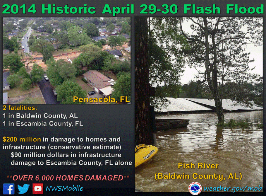
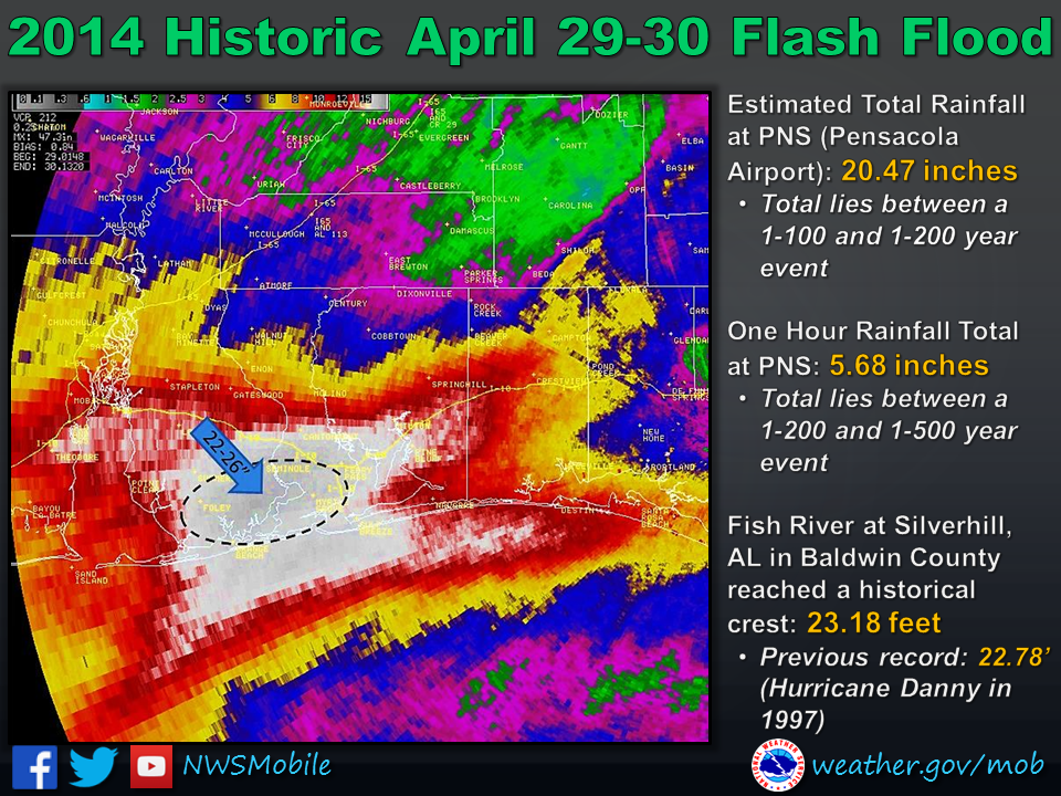 A historic rainfall event developed ahead of a slow moving cold front on Tuesday evening, 29 April 2014, over portions of coastal Alabama and northwest Florida Panhandle. The cold front was associated with a very powerful low pressure system in the Plains. Widespread flooding produced sinkholes (some very large and deep), cut roads in half and necessitated human water rescues (one confirmed fatality). Parts of I-10 were closed. The Fish River at Silver Hill (located in Baldwin County, AL) peaked at a record high level of 23.18 feet - the previous historical record was 22.78 feet on 20 July 1997. Many folks throughout the area have compared this event to the extreme flooding during Hurricane Danny in 1997.
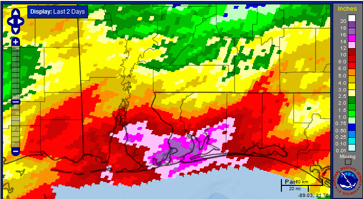
The radar estimated event rainfall total between 848pm on Monday April 28th and 920am on Wednesday, April 30th can be seen on the right.
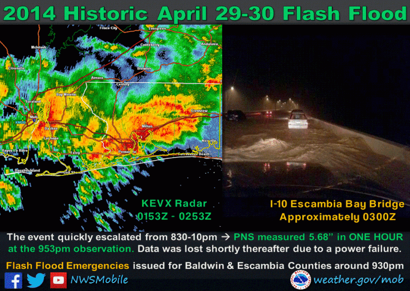
Historic rainfall totals were contributed to by two predominant rounds of storms. Round #1 began Monday night the 28th of April and lasted into the early morning hours of Tuesday, April 29th. Significant flash flooding occurred over coastal Alabama and northwest Florida as 3-8” of rain fell during the first round of storms The first round ended around 7am Tuesday 29 April. Round #2 was the more significant event, which occurred during the evening hours of Tuesday the 29th of April over Mobile and Baldwin counties in southern Alabama and into early morning hours Wednesday, April 30th over northwest Florida. 10-15” of rain fell in a very short time period (estimated 9 hours), which led to disastrous flooding throughout southern Baldwin County in Alabama and the northwest Florida Counties of Escambia, Santa Rosa and Okaloosa. The figures in the middle of this page depict how the rain fell over time across the entire area. CoCORaHS gauge reports are also included at the bottom of this webpage.
It is worth mentioning that leading into this historic event, rainfall totals for the previous two weeks and previous 30 days were 200-600% of normal according to 30 year PRISM Data. Also of note, the official NWS reporting sites at Mobile Regional Airport (MOB) and Pensacola Regional Airport (PNS) received record rainfall amounts on April 29th, 2014.
Mobile (MOB) Records
1-Day Rainfall Record: 11.24" on 04/29
3rd greatest calendar day total on record with data going back to 1871
This 24-hour total is a 1 in 25 year event (according to NOAA HDSC Precipitation Frequency Map)
Pensacola (PNS) Records
1-Day Rainfall Record: estimated 15.55" on 04/29
Data lost due to power outage between 10-11pm, so amounts estimated using Dual Pol radar precipitation
Greatest calendar day total on record with data going back to 1879
This 24-hour total lies between a 1 in 50 year and 1 in 100 year event
1-Hour Rainfall Note: 5.68" fell in 1 hour between 02Z-03Z on 04/29
This hourly amount lies between a 1 in 200 year and 1 in 500 year event
2-Day Rainfall Record: estimated 20.47"
This 2-day total lies between a 1 in 100 year and 1 in 200 year event
How did the Rain Fall over Time?
Below is the radar-estimated depiction of how the historic rains fell over time. The 2-day radar estimated event rainfall totals between 9am Monday, 28 April – 9am Wednesday, 30 April can be viewed in the first graphic below.
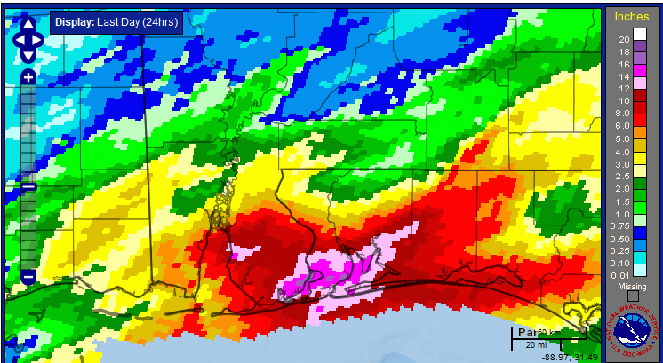
24-hour radar estimated rainfall totals between 9am Tuesday, 29 April – 9am Wednesday, 30 April can be viewed in the graphic below.
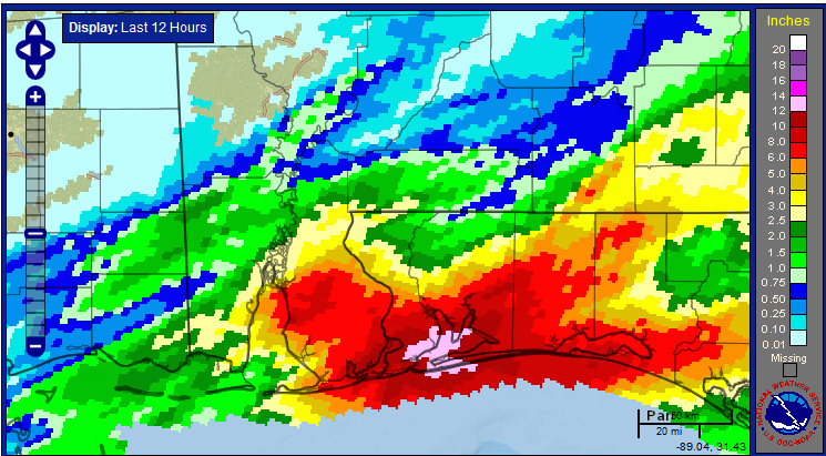
12-hour radar estimated rainfall totals between 9pm Tuesday, 29 April – 9am Wednesday, 30 April (round #2) can be viewed in the last graphic below.
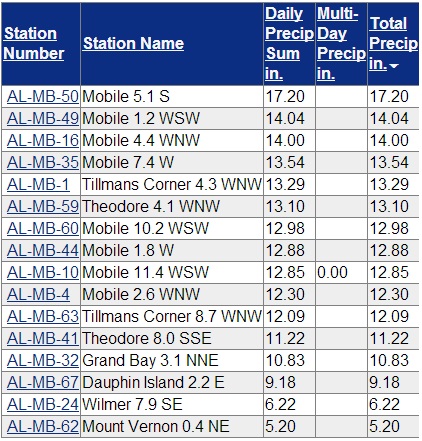
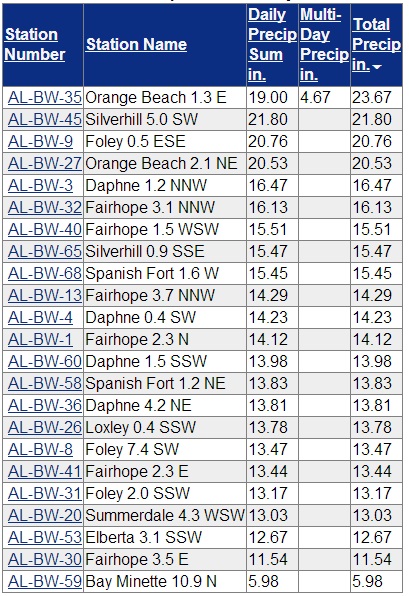
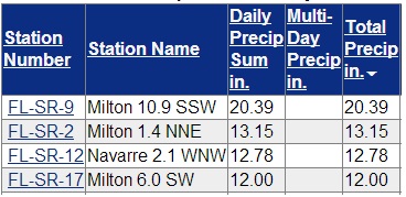
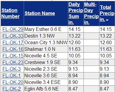
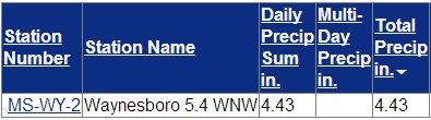
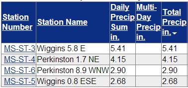
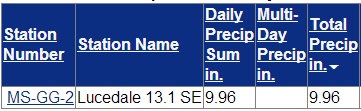
2-Day CoCoRaHS Rainfall Reports – All reports ending times vary. Data from 28-30 April, 2014.
Southwest Alabama - Mobile County
Southwest Alabama - Baldwin County
Northwest Florida - Escambia County
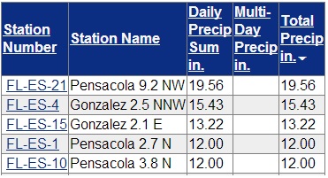
Northwest Florida - Santa Rosa County
Northwest Florida - Okaloosa County
Northwest Florida - 96th Weather Flight, Eglin AFB
| KVPS | Eglin AFB | 10.46 | 10.46 | |
| KEGI | Duke Field | 9.83 | 9.83 |
Southeast Mississippi - Wayne County
Southeast Mississippi - Stone County
Southeast Mississippi - George County
Acknowledgements: Page created by Joe Maniscalco and updated by Morgan Barry (forecaster).
LAST UPDATED: April 2019

