
October Tornado Event
October 25, 2019
Summary of all Local Storm Reports (LSRs) on Friday, October 25th, as well as all the LSRs across the region for this event.
Storm survey teams preliminarily concluded that there were 4 tornadoes that occurred in our forecast area - 1 EF0 and 2 EF1 tornadoes in Mobile County, AL and 1 EF1 tornado in Clarke County, AL.
The data provided on this page are considered preliminary as we continue to analyze all available data. We will add more information to this page and social media as it becomes available. We thank you in advance for your patience.
----- IMPORTANT 2023 UPDATE -----
Significant updates were made to several tornado tracks and wind swaths impacting the NWS Mobile/Pensacola area in the 2018 to 2023 timeframe thanks to the introduction of high-resolution Sentinel, Worldview, and Planet satellite imagery. One or multiple tornado tracks/wind swaths listed on this event webpage were updated in 2023.
An updated graphic and details surrounding these significant updates can be found in the list below. More information on this Local Tornado Reanalysis Project and a list of all updates can be found on our webpage at weather.gov/mob/TornadoReanalysis or the National Damage Viewer.
Here is a list of the significant updates:
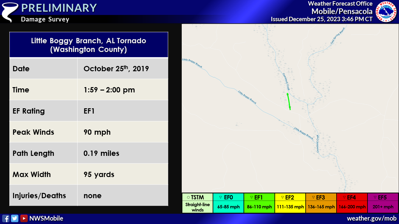
1. October 25, 2019 - New Tornado - Washington County, AL: A new, brief EF1 tornado was found near Little Boggy Branch in Washington County, AL based on Planet and Worldview satellite imagery. The tornado length is 0.19 miles, width is 95 yards and maximum intensity is 90 mph based on multiple trees uprooted in a convergent pattern on Worldview satellite imagery.
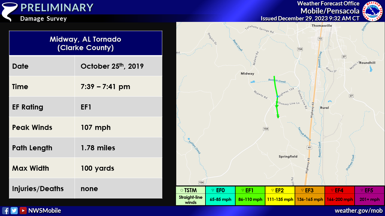
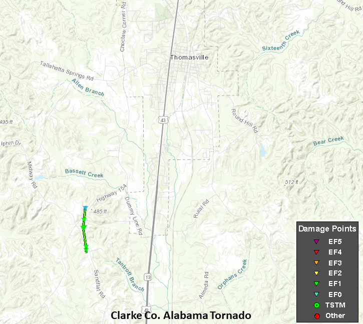
2. October 25, 2019 - Updated Tornado - Clarke County, AL: The length of the tornado that moved between the Midway and Thomasville communities in Clarke County, AL was extended further north based on a small path of uprooted trees noted on Planet satellite imagery. The EF1 intensity remains the same.
Public Information Statement
National Weather Service Mobile AL
103 PM CDT Tue Oct 29 2019

...Updated NWS Damage Survey Information For The October 25th Mobile County
Tornadoes...

.OVERVIEW...An NWS storm survey spent additional time in west Mobile and
identified an additional brief tornado near the intersection of Snow Road and
Airport Boulevard. This results in three separate tornado tracks in Mobile County.
All three tornadoes were produced from the same supercell thunderstorm.

.West Mobile Tornado #1...

Rating:                 EF-1
Estimated Peak Wind:    95-100 mph
Path Length /statute/:  1.3 miles
Path Width /maximum/:   75 yards
Fatalities:             0
Injuries:               0

Start Date:             Oct 25 2019
Start Time:             412 PM CDT
Start Location:         5 SW Mobile Regional Airport
Start Lat/Lon:          30.6144/-88.2686

End Date:               Oct 25 2019
End Time:               414 PM CDT
End Location:           4 SW Mobile Regional Airport
End Lat/Lon:            30.6337/-88.2715

Survey summary: The tornado first touched down just east of Arlington
Oaks Drive. The tornado intensified as it moved north northwest and
reached its peak intensity between Scott Dairy Loop Road and Johnson
Road. Significant tree and roof damage was noted in the Spring Brook
Farms subdivision, consistent with EF-1 damage. The tornado weakened
as it moved north of Johnson Road and lifted near Hamilton Creek.


.West Mobile Tornado #2...

Rating:                 EF-0
Estimated Peak Wind:    65 mph
Path Length /statute/:  0.09 miles
Path Width /maximum/:   25 yards
Fatalities:             0
Injuries:               0

Start Date:             Oct 25 2019
Start Time:             419 PM CDT
Start Location:         Near Intersection of Snow Rd/Airport Blvd
Start Lat/Lon:          30.6698/-88.2714

End Date:               Oct 25 2019
End Time:               420 PM CDT
End Location:           Near Intersection of Snow Rd/Airport Blvd
End Lat/Lon:            30.6711/-88.2716

Survey summary: Security camera footage from an NWS employee shows a brief
tornado touchdown on Gwinnett Court West just south of Airport Boulevard.
The tornado moved north and damaged the metal roof of a storage facility on
Airport Boulevard just east of Snow Road. The storm survey team could not find
any additional damage to the north of Airport Boulevard.


.Semmes AL Tornado...

Rating:                 EF-1
Estimated Peak Wind:    100-105 mph
Path Length /statute/:  3.34 miles
Path Width /maximum/:   100 yards
Fatalities:             0
Injuries:               1

Start Date:             Oct 25 2019
Start Time:             437 PM
Start Location:         1.7 NW Semmes
Start Lat/Lon:          30.7973/-88.2730

End Date:               Oct 25 2019
End Time:               442 PM
End Location:           4.7 NW Semmes
End Lat/Lon:            30.8452/-88.2739

Survey summary: The tornado first touched down near Stone Road and continued
north northwest, intensifying as it reached Jamaica Road and Box Road. This
is where the tornado was the strongest, producing extensive tree damage,
consistent with high end EF-1 intensity. The tornado continued north past
Coleman Dairy Road, producing damage at a mobile home park. The tornado
then crossed Lott Road and lifted shortly thereafter.

EF Scale: The Enhanced Fujita Scale classifies tornadoes into the
following categories.

EF0...Weak......65 to 85 mph
EF1...Weak......86 to 110 mph
EF2...Strong....111 to 135 mph
EF3...Strong....136 to 165 mph
EF4...Violent...166 to 200 mph
EF5...Violent...>200 mph

Note:
The information in this statement is preliminary and subject to
change pending final review of the events and publication in NWS
Storm Data.


Public Information Statement
National Weather Service Mobile AL
1009 AM CDT Tue Oct 29 2019

...NWS Damage Survey For October 25th Clarke County Tornado Event...

.OVERVIEW...An NWS storm survey identified a tornado that impacted northeast
Clarke County, southwest of Thomasville. This was part of the same storm
system that produced other tornadoes in the region on October 25th.

.CLARKE COUNTY TORNADO...

Rating:                 EF-1
Estimated Peak Wind:    105-110 mph
Path Length /statute/:  0.9 miles
Path Width /maximum/:   100 yards
Fatalities:             0
Injuries:               0

Start Date:             Oct 25 2019
Start Time:             739 PM CDT
Start Location:         4 SW Thomasville
Start Lat/Lon:          31.858/-87.7695

End Date:               Oct 25 2019
End Time:               741 PM CDT
End Location:           3.5 SW Thomasville
End Lat/Lon:            31.8712/-87.7698

Survey summary: The tornado touched down on the west side of Sandflat
Road and just west of John Rivers Lane. A home suffered significant roof
damage just after the tornado developed. The tornado continued north and
caused significant roof damage to a home on Gaddy Lane. There was evidence
of at least two distinct mesovortices embedded within the larger tornado
circulation. There was also extensive tree damage in this area with the
trunks of some hardwood trees snapped. The tornado continued north and
lifted north of State Highway 154.

EF Scale: The Enhanced Fujita Scale classifies tornadoes into the
following categories.

EF0...Weak......65 to 85 mph
EF1...Weak......86 to 110 mph
EF2...Strong....111 to 135 mph
EF3...Strong....136 to 165 mph
EF4...Violent...166 to 200 mph
EF5...Violent...>200 mph

Note:
The information in this statement is preliminary and subject to
change pending final review of the event and publication in
NWS Storm Data.
Acknowledgements: Page created by Joe Maniscalco (Forecaster). Page updated by Caitlin Baldwin (Forecaster).
LAST UPDATED: March 2024


