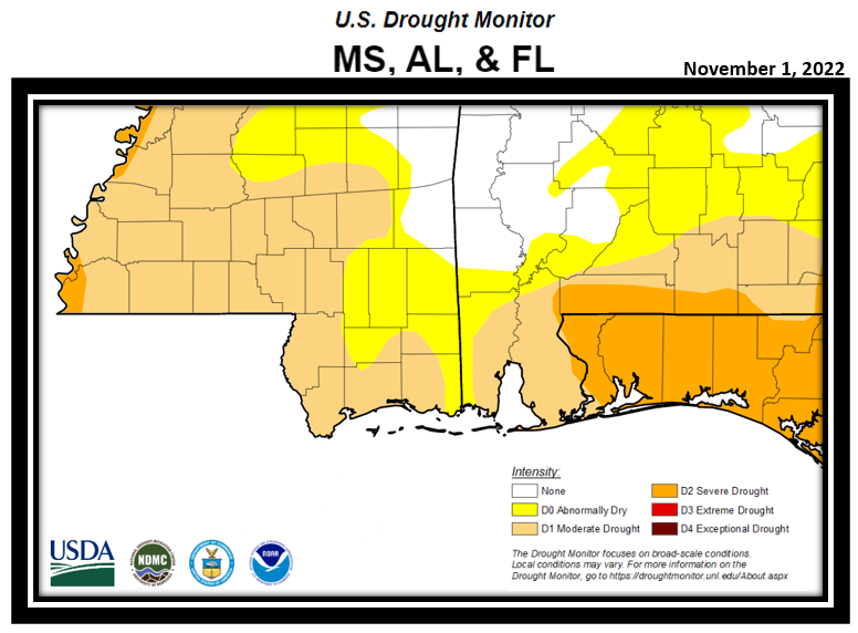
Severe Drought Holds Firm over the
Northwest Florida Panhandle, but eases
over Coastal Southwest Alabama
National Weather Service Mobile/Pensacola
Thursday 11/3/22
Current Drought Status...
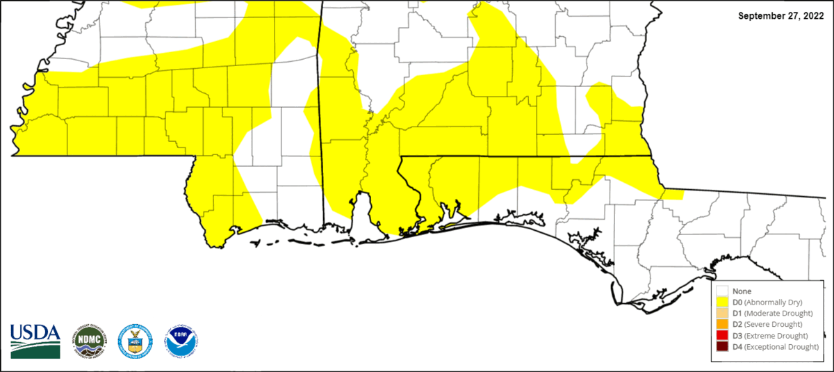
Drought Trends (Animated)...
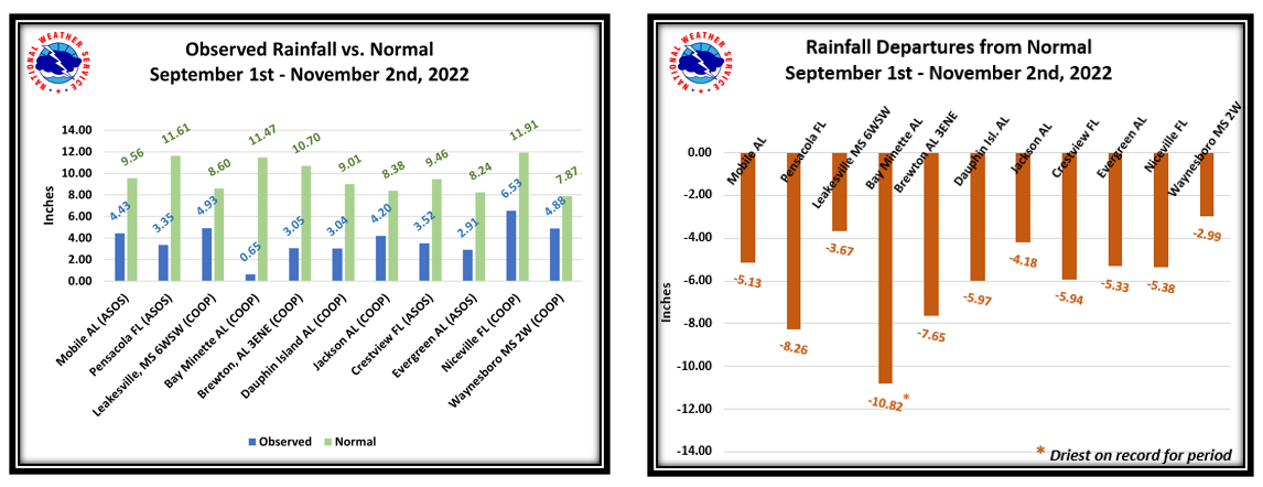
Climate Summary...
Despite much needed rainfall from the weather system that passed through on October 29th, rainfall deficits since the first of September continue to be substantially low, well below climatological normals entering the first week of November, ranging mostly 3 to 8 inches short of where we should be. In the list that follows, a notable mention is the city of Bay Minette which remains the driest on record during the period from September 1st to November 2nd with rainfall deficits nearing 11 inches below normal for the period.
To view areal precipitation for the NWS Mobile/Pensacola County Warning Area, provided by doppler radar precipitation estimates and calculations against normals, please refer to the following link: QPE:Quantitative Precipitation Estimates
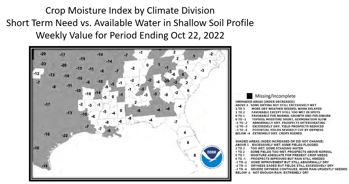
Local drought continues to result in a higher impact to grasslands and agriculture. With that said, severely dry conditions are taking its toll on winter crops with crop moisture index values very low which can cause crop yields to be severely cut or in some cases ruined. The following images show the latest crop moisture Index and soil moisture information. Source USDA: Latest Crop Bulletin
.png)
.png)
Downed timber that has become parched and very dry underbrush in area forests along with dry grasslands provide enough fuel to pose increased concern for wildfire. Please refer to the following links for the most up to date information for each state regarding any burn bans and advisories:
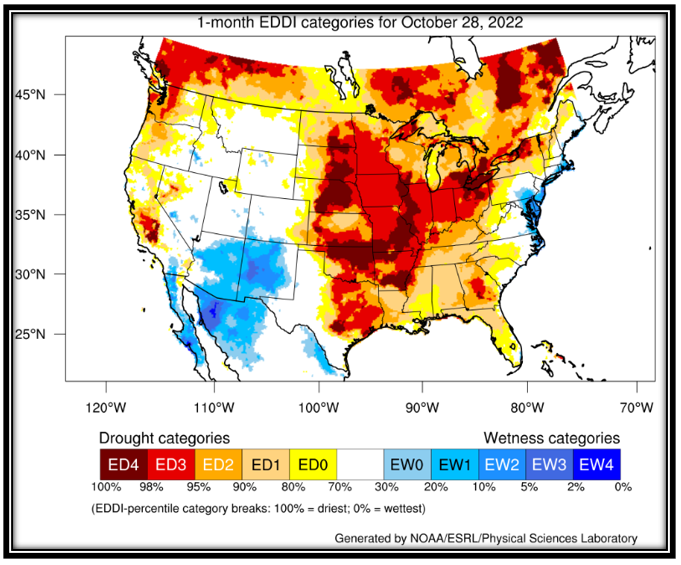
The latest 1-Month EDDI is provided below. EDDI is a drought monitoring and early warning guidance tool. It examines how anomalous the atmospheric evaporative demand (known as "the thirst of the atmosphere") is for a given location and across a time period of interest. EDDI can offer early warning of agricultural drought, hydrologic drought, and fire-weather risk by providing near-real-time information on the emergence or persistence of anomalous evaporative demand in a region. A particular strength of EDDI is in capturing the precursor signals of water stress at weekly to monthly timescales, which makes EDDI a strong tool for preparedness for both flash droughts and ongoing droughts.
Visit the Earth System Research Laboratory (ESRL) EDDI link for additional information on this tool. The 1-month EDDI as of the issuance date of this drought page is below.
Hydrologic Impacts and Short/Long Term Precipitation Outlooks...
Climate Prediction Center (CPC): Latest 6 to 10 Day Precipitation Outlook
CPC: Latest 8 to 14 Day Precipitation Outlook
CPC: Latest One Month Precipitation Outlook
CPC: Latest Seasonal Precipitation Outlook
Additional Links/Information:
Latest NWS Mobile/Pensacola Text Version of Drought Information Statement
Drought Monitor, Monthly Drought Outlook, Seasonal Drought Outlook
Acknowledgements: Page created by Joe Maniscalco, NWS Mobile/Pensacola Observation Program Leader
LAST UPDATED: November 3, 2022

