Late Spring Storm System Spawns
a Couple Brief Tornadoes
May 6 and 7, 2026
The NWS Mobile storm survey teams concluded that there were two brief tornadoes that were spawned from a late Spring storm system that brought multiple rounds of thunderstorms through the area Wednesday and Thursday May 6th and 7th. One dropped down and impacted Beaumont MS in Perry County and the second, northeast of Grand Bay AL in southern Mobile County. Both tornadoes were rated EF1. Please refer to the Local Storm Reports (LSRs) for May 6th and 7th, 2026 to view local and national storm reports.
We plan to supplement the storm surveys and analyze additional damage areas with high-resolution satellite imagery as it becomes available in the coming weeks. The data provided on this page are considered PRELIMINARY as we continue to analyze all available data. We will add more information to this page and social media as it becomes available. We thank you in advance for your patience.
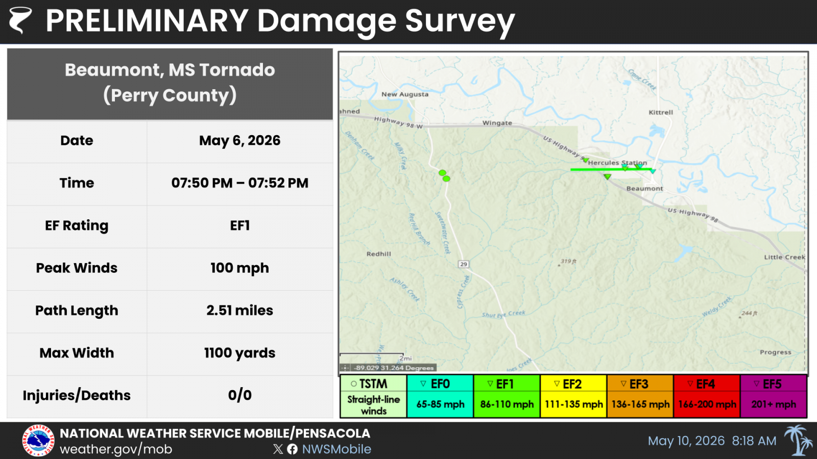
Beaumont Mississippi Tornado (Perry County, MS)
Public Information Statement
National Weather Service Mobile AL
611 PM CDT Fri May 8 2026

...NWS Damage Survey for 05/07/2026 Tornado Event...


.Beaumont Tornado...

Rating:                 EF1
Estimated Peak Wind:    100 mph
Path Length /statute/:  2.51 miles
Path Width /maximum/:   1100 yards
Fatalities:             0
Injuries:               0

Start Date:             05/06/2026
Start Time:             07:50 PM CDT
Start Location:         1 SE Ferguson / Perry County / MS
Start Lat/Lon:          31.1768 / -88.96340000000001

End Date:               05/06/2026
End Time:               07:52 PM CDT
End Location:           1 N Beaumont / Perry County / MS
End Lat/Lon:            31.1772 / -88.9209

Survey Summary:
Preliminary ground survey confirms EF1 damage beginning along US
Highway 98 between New Augusta and Beaumont, with multiple areas
of softwood and hardwood trees snapped or uprooted. Two
concentrated areas of tree damage were noted along US Highway 98,
suggesting multiple subvortices within a broader circulation. The
maximum intensity occurred around US Highway 98 with winds around
100 mph. The tornado continued generally eastward, crossing
Highway 198 and tracking along or near V L Toussaint Blvd before
weakening over the north side of Beaumont. Farther southwest,
sporadic tree damage was also observed along Highway 29 south of
New Augusta. Satellite data will be examined over the coming
weeks to determine the starting point for the tornado, as radar
suggests that it likely formed over a wooded area southwest of
New Augusta. Further track adjustments are likely once satellite
data is available.
Grand Bay Alabama Tornado (Mobile County, AL)
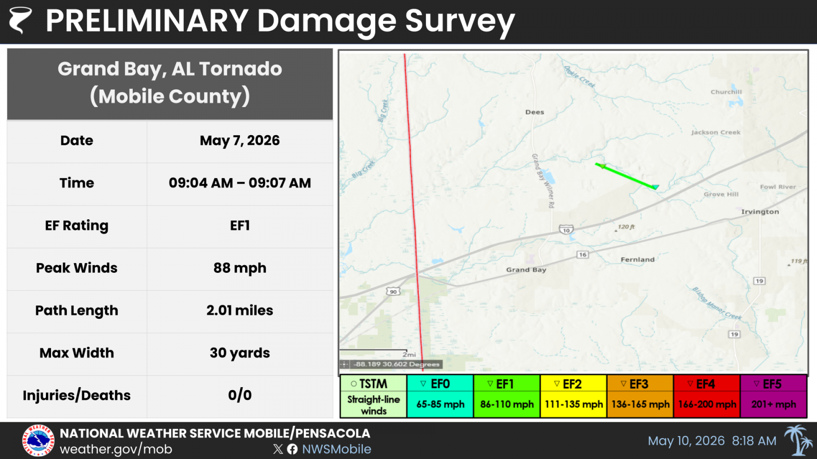
.Grand Bay Tornado...

Rating:                 EF1
Estimated Peak Wind:    88 mph
Path Length /statute/:  2.01 miles
Path Width /maximum/:   30 yards
Fatalities:             0
Injuries:               0

Start Date:             05/07/2026
Start Time:             09:04 AM CDT
Start Location:         3 SE Dees / Mobile County / AL
Start Lat/Lon:          30.5353 / -88.3138

End Date:               05/07/2026
End Time:               09:07 AM CDT
End Location:           2 WNW Saint Elmo / Mobile County / AL
End Lat/Lon:            30.5213 / -88.2843

Survey Summary:
Preliminary ground survey confirms low end EF1 damage northeast
of Grand Bay, Alabama. Maximum intensity of 88 mph was found on
Jim McNeil Loop Road where several large tree limbs were down
over a compact area. The tornado tracked southeast and produced
sporadic damage on Dedicated Road where a horse trailer was
flipped and more trees were damaged. After passing over Old
Pascagoula Road, additional tree damage with downed limbs and
snapped trees were found on Wells Road West. Satellite data will
be examined in the coming weeks to confirm the starting point of
the tornado, which is likely further to the northwest in wooded
areas over Jackson Creek east of Grand Bay Wilmer Road.
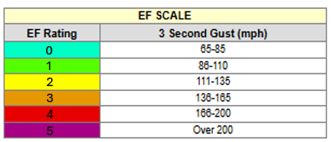
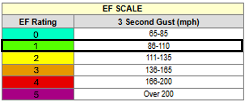
The Enhanced Fujita (EF) Scale classifies tornadoes into the following categories:


NOTE: THE INFORMATION ON THIS PAGE IS PRELIMINARY AND SUBJECT TO
CHANGE PENDING FINAL REVIEW OF THE EVENTS AND PUBLICATION IN
NWS STORM DATA.
NOTE: THE INFORMATION ON THIS PAGE IS PRELIMINARY AND SUBJECT TO
CHANGE PENDING FINAL REVIEW OF THE EVENTS AND PUBLICATION IN
NWS STORM DATA.
Additional Information
LAST UPDATED: May 10 2026

