April 2019 Climate Summaries
Mobile Alabama and Pensacola Florida Area
National Weather Service Mobile Alabama
May 2, 2019
April 2019 in Review - Daytime highs for the month of April were very close to seasonal. While there were several periods of much more pronounced low temperatures that sank to well below normal throughout the month, the average overnight lows also settled to very close to seasonal. The Mobile and Pensacola area each saw 1 new record temperature. For rainfall, April saw the flip side. After a very dry March, area rain gauges saw a surplus of rainfall to above normal April levels. Even so, abnormal annual dryness persists.
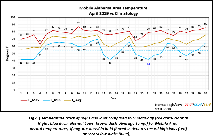
Mobile Alabama Area - The average monthly high of 78.2° was 0.7° above normal. The average monthly low of 55.2° was 0.2° below normal. The average monthly temperature of 66.7° was 0.3° above normal. The Mobile area saw 1 new record temperature. A record low of 42° on the 21st broke the previous of record 43° previously set on this date back in 1953.
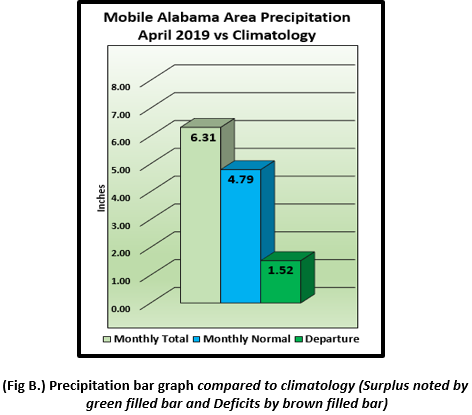
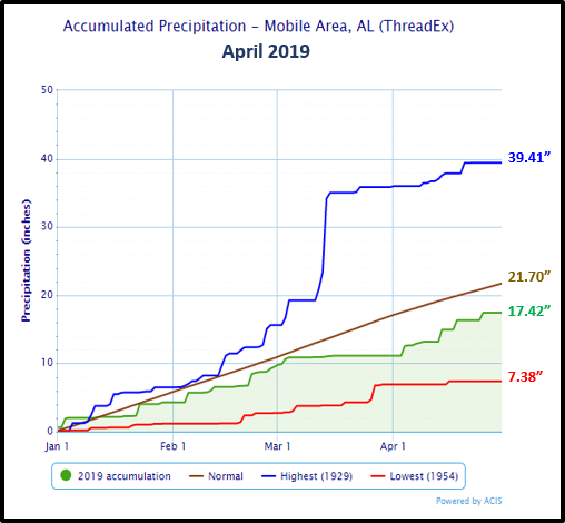
(Fig. A) shows how the Mobile area temperatures compared to the seasonal normal monthly highs and lows, which are shown by the colored dashed lines. April rainfall (Fig. B) recovered, measuring 6.31" or 1.52" above normal. 2019's accumulated rainfall through April is also provided below, bounded by the traces of all time max (year of occurrence), min (year of occurrence) and average precipitation ending for the month. Mobile continues to reflect an annual water deficit. Now just above 4 inches.
Click on the Mobile Alabama area climate graphics below to expand:
|
|
Against Climatology |
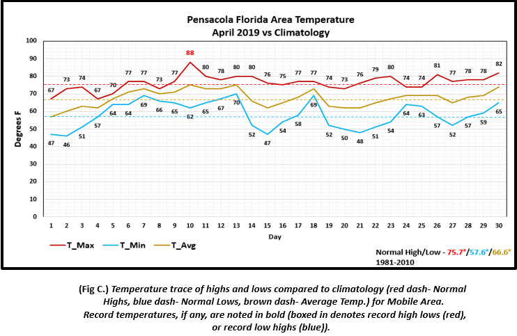
Pensacola Florida Area - The average monthly high of 76.4° was 0.7° above normal. The average monthly low of 58.2° was 0.6° above normal. The average monthly temperature of 67.3° was 0.7° above normal. The Pensacola area saw 1 record temperature. A record high of 88° set on the 10th broke the previous record of 86° occurring on this date in 1999.
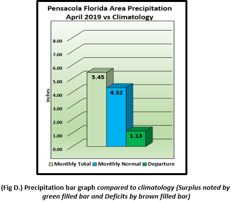
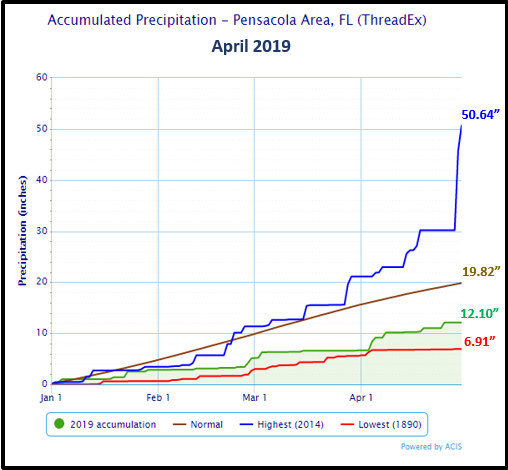
(Fig. C) shows how the Pensacola area temperatures compared to the seasonal normal monthly highs and lows, which are shown by the colored dashed lines. Similar to that of the Mobile area, Pensacola area rainfall surpassed the monthly normal. (Fig. D) shows a measurement 5.45" or 1.13" above normal. 2019's accumulated rainfall through April is also provided below, bounded by the traces of all time max (year of occurrence), min (year of occurrence) and average precipitation ending for the month. Pensacola continues to experience an annual water deficit now at just under 8 inches.
Click on the Pensacola Florida area climate graphics below to expand:
|
|
Against Climatology |
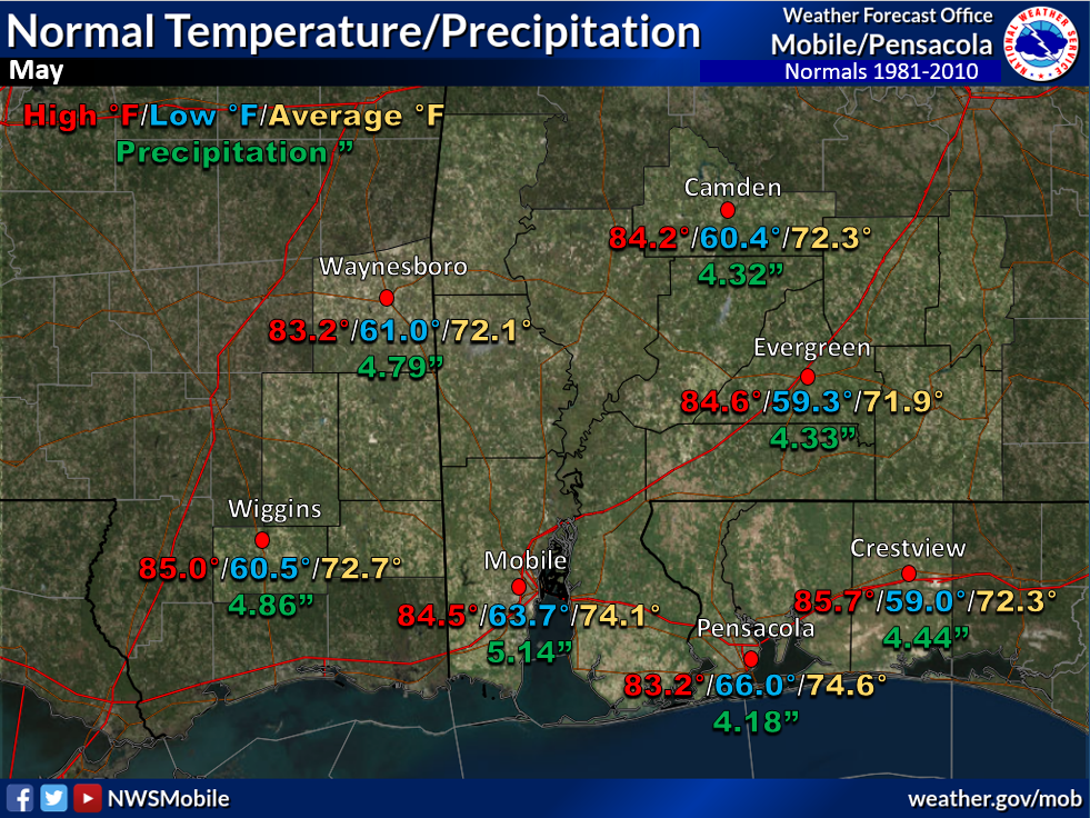
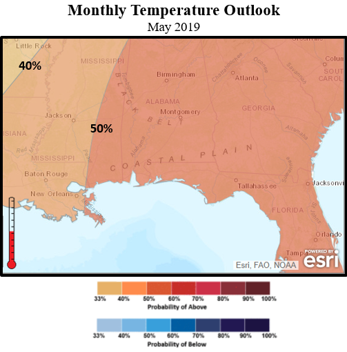
May Climatology and Outlooks:
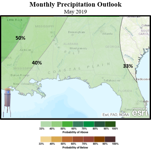
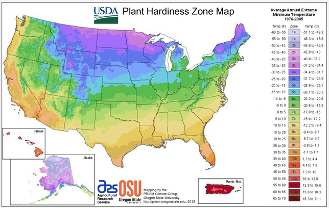
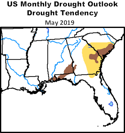
Gardening time is well underway along the central Gulf coast and the main negative impacts to residential and commercial growers is abnormal dryness. Portions of the coastal plain, specifically from Mobile county eastward to across much of the northwest Florida Panhandle, is undergoing moderate drought conditions. Unfortunately, the outlook for May continues to favor drought conditions lingering. Plans for supplemental watering initiatives should be considered for gardens. The best focus for longer duration heavier rains is favored well off to the west and northwest of the local area from northeast Texas up across the central Mississippi River Valley during the month of May.
Click on the snap shots below to expand:
|
Outlook |
Outlook |
Map by USDA |
|
Information |
Climate Prediction Center's Interactive Long Range Outlooks
Additional Climate Links:
The links below are intended to provide additional climate information, education and outlooks. The National Weather Service Mobile Alabama's Climate and Past Weatherpage provides climate data at your fingertips for many observation points in the local forecast area by accessing the NOWData tab as well as many other climate resources. The Climate Prediction Center Link provides short and longer range climatic outlooks and education about the larger scale global circulations that impact temperatures and weather. With the large agriculture and farming presence along the central Gulf coast, the Drought Monitor link provides updates on drought trends and impacts. Another very helpful resource is the Community Collaborative Rain Hail and Snow (CoCoRaHS) network, which is a large group of volunteers working together to measure and map precipitation (rain, hail and snow). The aim of CoCoRaHS is to provide the highest quality data for natural resource, education and research applications. You can be a part of the CoCoRaHS team by becoming a volunteer rainfall observer. To learn more click on the CoCoRaHS link below.
National Weather Service Mobile AL Climate and Past Weather
Climate Prediction Center (CPC)
CoCoRaHS Network Water Year Summaries