
Tropical Storm Barry - August 6, 2001
 Barry began life over the southeastern Gulf from a cluster of strong thunderstorms associated with a trough of low pressure moving through the area. Air Force Reserve Hurricane Hunter aircraft found a weak circulation embedded within the thunderstorm activity on August 2nd, 2001. For the next several days, Tropical Storm Barry made a slow northwest track toward New Orleans, barely holding tropical storm strength.
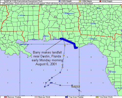
By August 4th, Tropical Storm Barry was nearly stationary approximately 250 miles south of Destin, FL. That evening, Barry starting making a distinct northward drift. This drifting pattern continued through the next day as Tropical Storm Barry steadily intensified over the warm Gulf waters and in the light winds aloft. Tropical Storm Barry nearly reached hurricane strength before making landfall near Destin, FL in the early morning hours on Monday August 6.
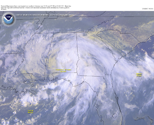
Satellite imagery from Monday, August 6th (around 9am) can be viewed on the right. By this time, Tropical Storm Barry was considerably weaker as it made its way north-northwest through southern Alabama. The path of Tropical Storm Barry can be seen in the first image below. The second image below is KEVX radar from late Sunday evening showing Tropical Storm Barry as it was about to make landfall. Note the nearly circular eyewall on Barry at this time!

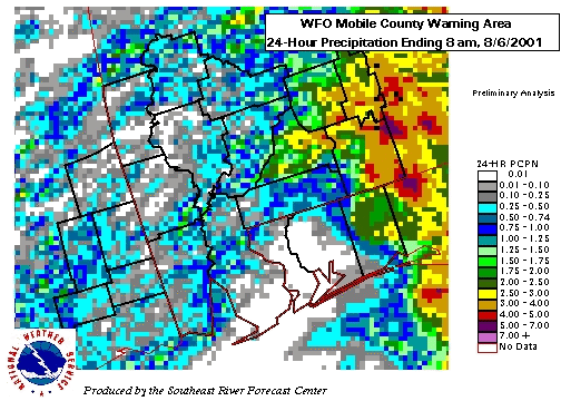
Heavy rainfall continued to fall across the fringe of our southern Alabama counties, mainly east of the I-65 corridor. The graphic below shows the 24-hour rainfall estimates for southeast Mississippi, southwest Alabama and the western Florida Panhandle. Since Tropical Storm Barry made landfall in the far eastern portion of our area (Destin, FL), the heaviest rainfall occurred east of our county warning area from Panama City, FL through Troy, AL. The highest 24-hour rainfall totals fell at Eglin Air Force Base with almost 4 inches recorded during the event. Minor flooding was reported across some of the Florida panhandle and southern Alabama, but no major damage was reported.
Most of the damage along coastal Alabama was minor beach erosion. A new berm on Dauphin Island (built to protect homes against storm surge) had a 20-foot section of the berm washed away. Storm surge in coastal Mobile and Baldwin counties was estimated at 1-2 feet and slightly higher across northwest Florida with 2-3 feet.
Further inland, majority of the damage came from the winds of Barry. Near the center and just to the right of the center, numerous trees and structures were damaged. The counties with the most damage were Covington, Crenshaw and Butler Counties in south Alabama. Numerous trees were blown down from Florala to Andalusia in Covington County, AL. Some damage to awnings and structures also occurred in Florala. More trees were blown down across Butler and Crenshaw counties. Further northwest, minor damage occurred in Conecuh, Monroe and Wilcox Counties in southwest Alabama with most of that being trees blown down. Across the coastal counties, numerous trees and structures were damaged, especially from Destin to Crestview, FL in Okaloosa County. The highest wind speed measured was a gust of 65mph at Eglin Air Force Base.
Additional Information
NHC Advisory Archive
WPC Archive
NHC Tropical Cyclone Report - Tropical Storm Barry
Acknowledgements: Page updated by Morgan Barry (forecaster).
LAST UPDATED: July 2019

