February 2019 Climate Summaries
Mobile Alabama and Pensacola Florida Area
National Weather Service Mobile Alabama
March 6, 2019
February 2019 in Review - Similar to February of last year, February of this year was one for the record books. Outside of a few days where temperatures where near normal, numbers where well above climatology and meeting or exceeding several records. The Mobile area saw 6 record temperatures and the Pensacola area 2. For rainfall, Mobile saw a record one day rainfall being surpassed.
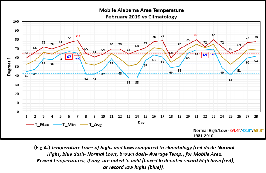
Mobile Alabama Area - The average monthly high of 70.9° or 6.5° above normal ranks 6th all time warmest in the period of record dating back to 1872. The average monthly low of 54.9° or 11.6° above normal ranks 4th all time warmest. The average monthly temperature of 62.9° or 9.1° above normal now stands at 3rd all time warmest. Mobile saw 6 record temperatures being tied or broken, 2 of which new record highs and 4 record high low temperatures. 79° on the 7th broke the old record of 78° set in 2018. 80° on the 21st tied the previous record also set in 2018. Here is a break down of the 4 record high lows: 67° on the 6th broke the old record of 64° set way back in 1927. 65° on the 7th tied the previous record set way back in 1911. 69° on the 22nd tied the previous record set in 2018 and 70° on the 23rd tied the previous record set in 1962.
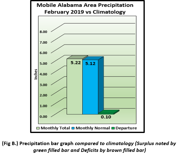
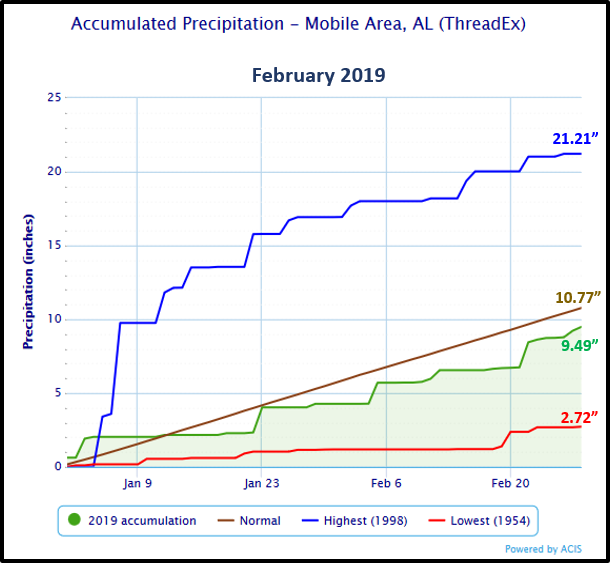
(Fig. A) shows how the Mobile area temperatures compared to the seasonal normal monthly highs and lows, which are shown by the colored dashed lines. February rainfall was very close to seasonal normal, measuring 5.22" or 0.10" above normal . On the 22nd, Mobile's rain gauge measured a one day maximum rainfall of 1.70" which broke the old record by a few hundredths of an inch, 1.66" set on that day in 2013. (Fig. B). Accumulated precipitation is also provided below, which shows the all time max (year of occurrence), min (year of occurrence) and average precipitation ending for the month.
Click on the Mobile Alabama area climate graphics below to expand:
|
|
Against Climatology |
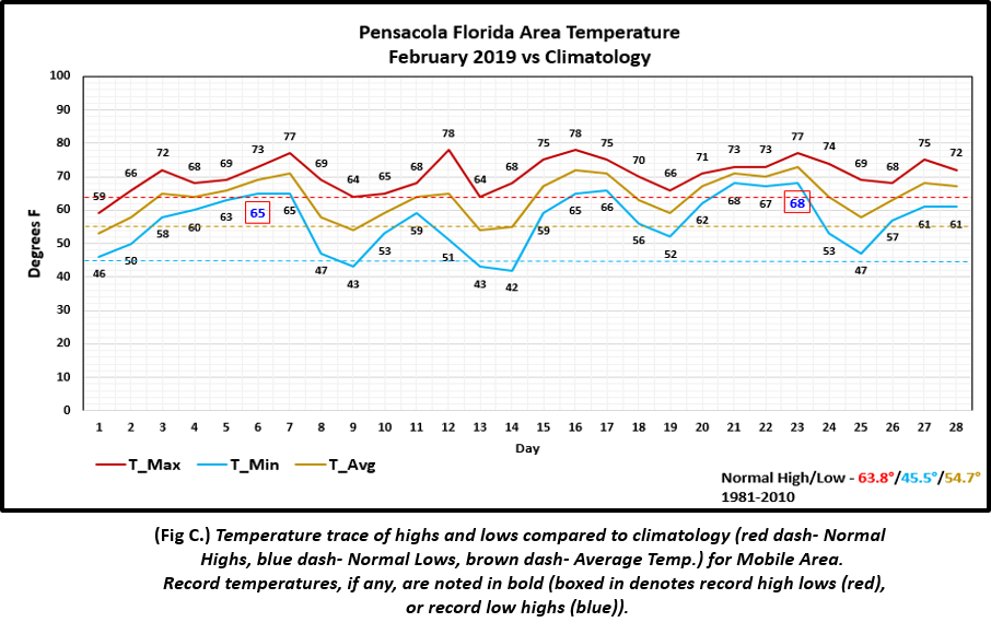
Pensacola Florida Area - The average monthly high of 70.6° or 6.8° above normal ranks 4th all time warmest in the period of record dating back to 1879. The average monthly low of 56.7° or 11.2° above normal also ranks 4th all time warmest. The average monthly temperature of 63.6° or 8.9° above normal now stands at 2nd all time warmest behind last year which was number 1. Pensacola saw 2 record high lows: 65° on the 6th tied the previous record set way back in 1911 and 68° on the 23rd broke the old record of 67° set in 2012.
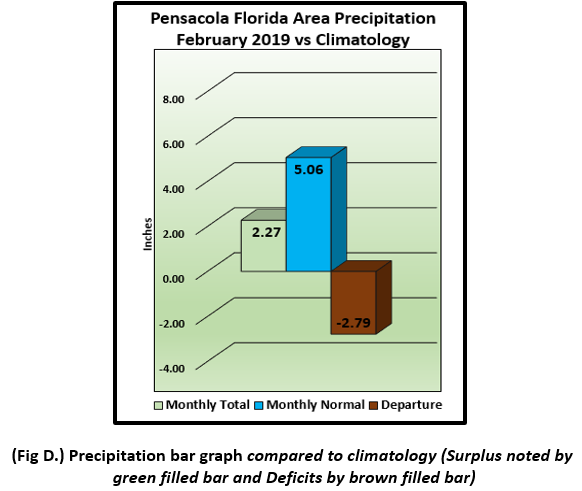
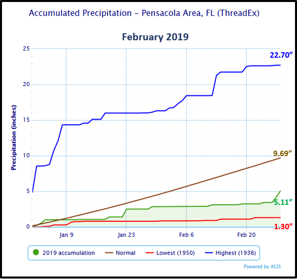
(Fig. C) shows how the Pensacola area temperatures compared to the seasonal normal monthly highs and lows, which are shown by the colored dashed lines. Pensacola area rainfall measured 2.27" or 2.79" below normal (Fig. D). Accumulated precipitation is also provided below, which shows the all time max (year of occurrence), min (year of occurrence) and average precipitation ending for the month.
Click on the Pensacola Florida area climate graphics below to expand:
|
|
Against Climatology |
March Climatology and Outlooks:
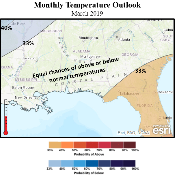
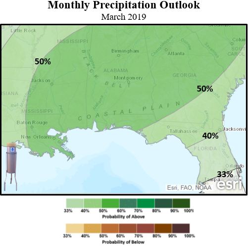
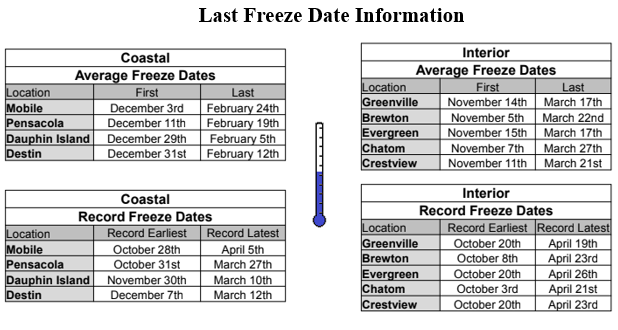
A potentially active southern stream in the long range outlooks favor the potential of excessive rains over the deep south. Some local river stages could remain elevated especially over the Tombigbee and Alabama River waterways along the coastal plain. Local rivers to the west, into southern Mississippi, could also see an increasing stage response. Although we came out of an unseasonably warm and record breaking February, spring-time gardening efforts can be negatively impacted by freezing temperatures into March. An equal chance of above or below normal temperatures is favored.
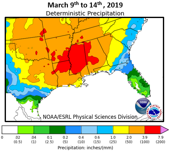
Click on the snap shots below to expand:
|
Outlook |
Outlook |
|
|
Information |
Climate Prediction Center's Interactive Long Range Outlooks
Additional Climate Links:
The links below are intended to provide additional climate information, education and outlooks. The National Weather Service Mobile Alabama's Climate and Past Weather page provides climate data at your fingertips for many observation points in the local forecast area by accessing the NOWData tab as well as many other climate resources. The Climate Prediction Center Link provides short and longer range climatic outlooks and education about the larger scale global circulations that impact temperatures and weather. With the large agriculture and farming presence along the central Gulf coast, the Drought Monitor link provides updates on drought trends and impacts. Another very helpful resource is the Community Collaborative Rain Hail and Snow (CoCoRaHS) network, which is a large group of volunteers working together to measure and map precipitation (rain, hail and snow). The aim of CoCoRaHS is to provide the highest quality data for natural resource, education and research applications. You can be a part of the CoCoRaHS team by becoming a volunteer rainfall observer. To learn more click on the CoCoRaHS link below.
National Weather Service Mobile AL Climate and Past Weather
Climate Prediction Center (CPC)
CoCoRaHS Network Water Year Summaries