
Hole Punch Clouds
Mobile, AL - Observed on December 11, 2003
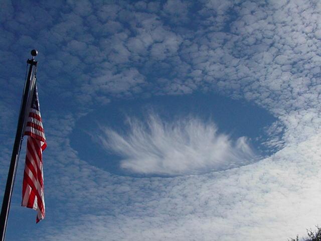

Photo courtesy of Gary Beeler (former Warning Coordination Meteorologist)
What Happened?
During the early afternoon of December 11, 2003, a strange and unusual cloud formation occurred over the Mobile, AL area. The name..."Hole Punch Clouds".
Has it happened before?
Yes. A quick internet search quickly reveals a few strikingly similar past photos that were taken in south Florida, the Carolinas and even Australia and Canada. Therefore one can conclude that the phenomena has happened before, but on a relatively infrequent basis.
At what atmospheric level did this occur?
To the right, a regional sounding (meteorological instrumentation that shows how temperature and moisture vary with height) from Valparaiso, FL reveals a cloud layer between approximately 25-27,000 feet. The cloud layer was likely a few 1,000 feet lower according to a sounding taken further west over Slidell, LA near the time of sunset.
Meteorologists refer to clouds at this level as cirro-form clouds. Generically, these are termed high clouds. However, the white puffy-like texture in the cloud deck that surrounds the hole possesses traits of both cirroform and cumulo-form clouds (form at much lower altitudes). Cirroform clouds with a cumulus-like appearance are termed cirrocumulus clouds.
What was the weather pattern that day?
Although a large scale high pressure system was building in at the surface with northerly winds, the hole punch clouds occurred at a much higher level in the atmosphere. Just above the cloud layer and at 32,000 feet above ground level, the upper level winds were blowing from west to east over much of the Deep South. The clouds were aligned along this rapidly flowing stream of air, known as the jet stream. The surface and 300mb charts for this time period can be viewed below.
How does the hole occur in the clouds?
The puffy clouds were likely composed of ice crystals and very small super-cooled liquid water droplets. Studies have shown that very small supercooled liquid water droplets can exist well below freezing (as low as -40°C). The temperature in the cloud layer was around -24°C at the time of occurrence. Sometimes, when ice and the supercooled liquid droplets coexist within a cloud, a process occurs whereby ice crystals grow at the expense of the droplets. If the mixed cloud is agitated, the supercooled droplets freeze instantaneously. It is understood through microphysical arguments that water vapor must evaporate from the surrounding supercooled droplets and flow towards the ice crystals. This would start a cycle whereby newly formed ice crystals cause the surrounding droplet to evaporate, resulting in a circular form void of clouds with a mass of crystals in the center. Many photos taken that day seem to represent this process.
What caused the disturbance to begin? 
One possible explanation is a jet plane. Visible satellite imagery that day suggested several "hole punch" clouds over both southern MS and AL. These coincided with jet contrails.
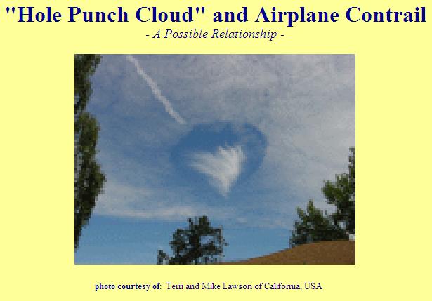
The image to the right shows the "hole punch" clouds in Australia with an airplane contrail nearby.
An airplane passing through the mixed cloud layer while ascending or descending would likely disrupt the delicate coexistence between the ice crystals and the supercooled liquid water droplets. A second possible explanation is that small scale atmospheric vertical motions (both up and down) related to the jet stream brought ice crystals downward into the moist cloud layer, thus effectively 'setting off' the cyclic process described above.
One thing is for sure...
Without an ability to directly measure these small scale vertical motions and the quantities of temperature and moisture directly within and adjacent to the actual clouds, we can only speculate on what caused this common but relatively infrequent awesome phenomena to occur...
Acknowledgements: Page was contributed to by several members of the NWS Staff in Mobile including: John Purdy (Meteorologist), Gene Jacobi (Hyrdometeorological Technician), Don Shepherd (Meteorologist), Andy Stasiowski (former Hyrdometeorological Technician), Jason Beaman (former intern, now WCM), Gary Beeler (former WCM) and Jeffrey Medlin (former SOO, now MIC).
LAST UPDATED: December 2017

