January 2018 Graphical Climate Summaries
Mobile Alabama and Pensacola Florida Area
National Weather Service Mobile Alabama
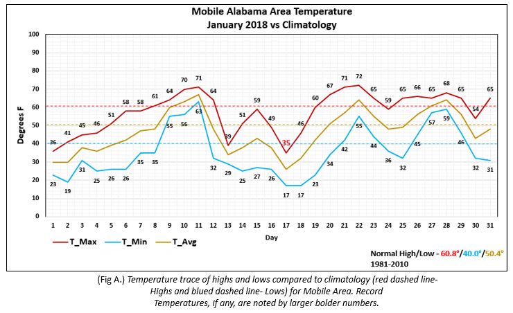
Mobile Alabama Area - January saw a series of arctic intrusions deep into the south, resulting in notable periods of large temperature anomalies/extremes against the climatic normal. The first occurrence the first several days of the new year, the second and third into the middle of the month. Within this span, there were days when the daytime highs were some 15 to 20° below normal and nighttime lows even colder, some 20 to 25° below normal. The average monthly high was 57.6° or 3.2° below normal. The average monthly low was 35.6° or 4.4° below normal. The average monthly temperature was 46.9° or 3.5° below normal. A record low, high temperature of 35° occurred on the 17th. (Fig. A) shows how the numbers compared to the seasonal normal monthly highs and lows, which are shown by the colored dashed lines.
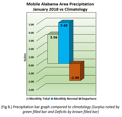
January's rainfall measured 3.56" or 2.09" below normal (Fig. B). Also of note was the occurrence of sleet and snow, measuring 0.1" on the morning of January 17th. This marks only the second time in recorded history that two measurable snow events occurred in the same winter season (December through February) in Mobile. The first measurable event of the winter occurred on December 8-9, 2017. The only other time that two measurable snow events occurred in the same winter season in Mobile was 1976/1977 (January 18th and 31st in 1977).
Click on the Mobile Alabama area climate graphics below to expand:
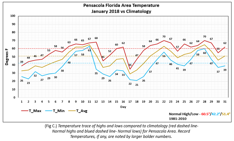
Pensacola Florida Area - January saw a series of arctic intrusions deep into the south, resulting in notable periods of large temperature anomalies/extremes against the climatic normal. The first occurrence the first several days of the new year, the second and third into the middle of the month. Within this span, there were days when the daytime highs were some 15 to 20° below normal and nighttime lows even colder, some 20 to 25° below normal. The average monthly high was 58.1° or 2.4° below normal.The average monthly low was 39.1° or 3.1° below normal. The average monthly temperature was 48.8° or 2.6° below normal. (Fig. C) shows how the numbers compared to the seasonal normal monthly highs and lows, which are shown by the colored dashed lines.
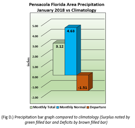
January's rainfall measured 3.12" or 1.51" below normal (Fig. D).
Click on the Pensacola Florida area climate graphics below to expand:
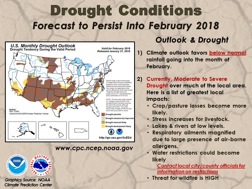
Climate Outlook:
With the local area seeing a worsening in drought conditions, the outlook this month is based upon it and the potential local impacts to area growers, farmers, fire weather and public health agencies.
Click on the graphic below to expand:
For more information on the drought and local trends, including tri-state (MS-AL-FL) burn bans, visit the Drought Information Page posted by the National Weather Service Mobile. In addition, a text version of the latest Drought Information Statement is included in the page.
Additional Climate Links:
The links below are intended to provide additional climate information, education and outlooks. The National Weather Service Mobile Alabama's Climate and Past Weather page provides climate data at your fingertips for many observation points in the local forecast area by accessing the NOWData tab as well as many other climate resources. The Climate Prediction Center Link provides short and longer range climatic outlooks and education about the larger scale global circulations that impact temperatures and weather. With the large agriculture and farming presence along the central Gulf coast, the Drought Monitor link provides updates on drought trends and impacts. Another very helpful resource is the Community Collaborative Rain Hail and Snow (CoCoRaHS) network, which is a large group of volunteers working together to measure and map precipitation (rain, hail and snow). The aim of CoCoRaHS is to provide the highest quality data for natural resource, education and research applications.
National Weather Service Mobile AL Climate and Past Weather
Climate Prediction Center (CPC)
CoCoRaHS Network Water Year Summaries