May 2020 Climate Summaries
Mobile Alabama and Pensacola Florida Area
National Weather Service Mobile Alabama
June 2, 2020
May 2020 in Review - The first two weeks of the month saw a period of below normal low temperatures, before rising and following more of a climatological normal trace the remainder of the month. Outside of a few peaks and valleys about the climatological means, daytime highs were mostly close to normal. Given the fact that the Gulf coast has been dealing with moderate to severe drought for weeks, one would come to expect quite a number of record highs being tied or exceeded. However, this didn't happen this month. The only record was in the low temperature department occurring on the 1st of the month at Mobile. It continued dry for a little over three weeks at Mobile which saw monthly rainfall to two inches below monthly normal up to the 25th. Following was a more unsettled weather pattern the 26 through the 28th which saw a period of more in the way of scattered to numerous storms providing enough rain to exceed normal those three days. The Pensacola area though was too far to the south of the more substantial rainfall and unfortunately saw a substantial monthly deficit over 2.5 inches. Annual rainfall deficits remain notable. Although Mobile improved in rain amounts for the month, the annual total in the gauge was short by a little over seven inches. At Pensacola, the annual rainfall deficits were near 7.5 inches.
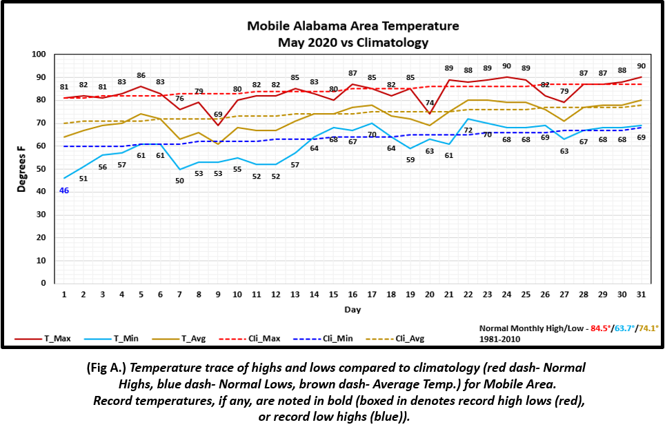
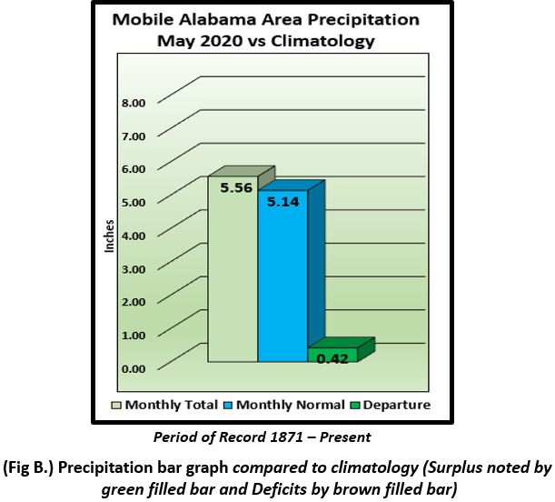
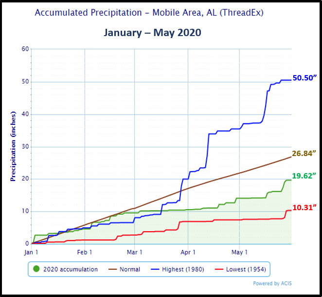
Mobile Alabama Area [Climate Normal Period 1981-2010, Climate Record Period 1872 to Present]- The average monthly high of 83.3° was 1.2° below normal. The average monthly low was 61.4° or 2.3° below normal. The average monthly temperature of 72.3° was 1.8° below normal. (Fig. A) shows a graphical representation of how the Mobile area temperatures compared to the seasonal normal monthly highs and lows, which are shown by the colored dashed lines. There was one record low temperature and this was met on the 1st of the month at 46° which tied the previous record occurrence on this date back in 1999. Total rainfall for May (Fig. B) measured 5.56" or 0.42" above normal. A precipitation trace for the Mobile area since January 1st is provided in the graphics below showing how it compares to normal year to date totals. The Mobile area annual rainfall continues to lag well below normal by 7.22" which has contributed to the occurrence of moderate to severe drought conditions over Mobile county.
May's top records for the month during the Period of Record:
Click on the Mobile Alabama area climate graphics below to expand:
|
|
|
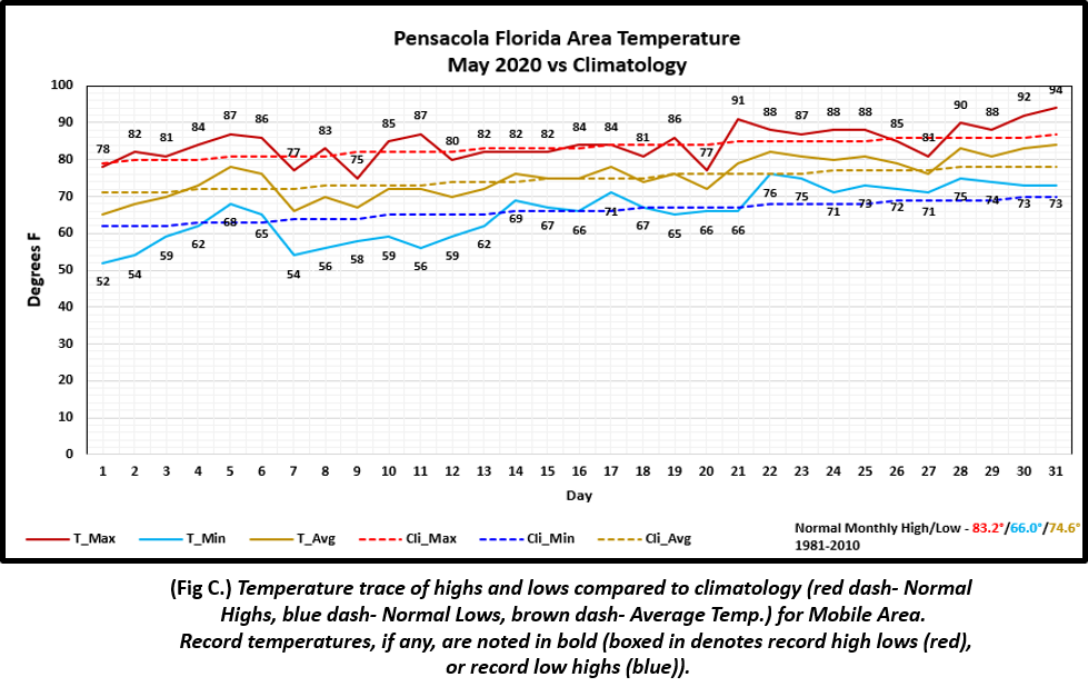
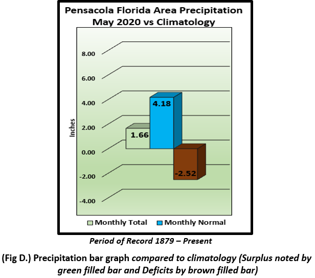
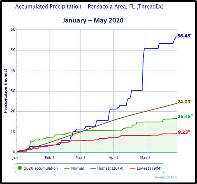
Pensacola Florida Area [Climate Normal Period 1981-2010, Climate Record Period 1879 to Present] - The average monthly high of 84.4° was 1.2° above normal. The average monthly low of 65.6° was 0.4° below normal. The average monthly temperature of 75.0° was 0.4° above normal. (Fig. C) shows a graphical representation of how the Pensacola area temperatures compared to the seasonal normal monthly highs and lows, which are shown by the colored dashed lines. No record temperatures were reached this month. Not much rain observed at Pensacola (Fig. D), where the gauge only collected 1.66" or 2.52" below normal. A precipitation trace for the Pensacola area is provided in the graphics below showing how it compares to normal year to date totals. The Pensacola area annual rainfall continues to lag well below normal by 7.52" which has contributed to moderate drought conditions over Escambia county.
May's top records for the month during the Period of Record:
Click on the Pensacola Florida area climate graphics below to expand:
|
|
|
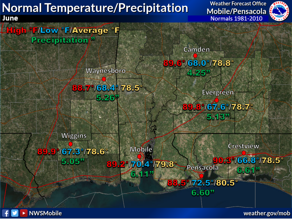
June Climatology and Outlooks:
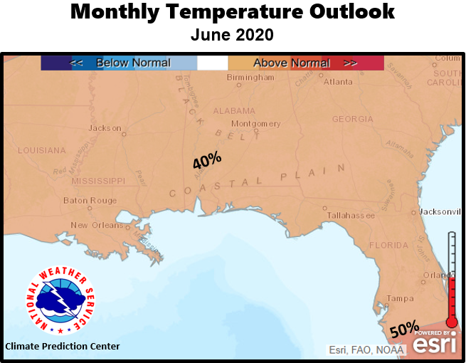
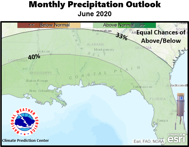
The latest monthly outlook favors a modest chance (40-49%) of above normal temperatures over the southeast US. The deep south is in need of rain, especially those counties closer to the coast which continue to experience moderate to severe drought. Fortunately, there may be a change this month with a (40%) probability of above normal rain outlooked for the month of June over the coastal plain. For more specific information on local drought conditions and outlooks, click on the drought information and facts link below.
Click on the snap shots below to expand:
|
Outlook |
Outlook |
|
Climate Prediction Center's Interactive Long Range Outlooks
Additional Climate Links:
The links below are intended to provide additional climate information, education and outlooks. The National Weather Service Mobile Alabama's Climate and Past Weather page provides climate data at your fingertips for many observation points in the local forecast area by accessing the NOWData tab as well as many other climate resources. The Climate Prediction Center Link provides short and longer range climatic outlooks and education about the larger scale global circulations that impact temperatures and weather. With the large agriculture and farming presence along the central Gulf coast, the Drought Monitor link provides updates on drought trends and impacts. Another very helpful resource is the Community Collaborative Rain Hail and Snow (CoCoRaHS) network, which is a large group of volunteers working together to measure and map precipitation (rain, hail and snow). The aim of CoCoRaHS is to provide the highest quality data for natural resource, education and research applications. You can be a part of the CoCoRaHS team by becoming a volunteer rainfall observer. To learn more click on the CoCoRaHS link below.
National Weather Service Mobile AL Climate and Past Weather
Climate Prediction Center (CPC)
CoCoRaHS Network Water Year Summaries