
Remnants of Tropical Storm Allison - June 11, 2001
 The 2001 Hurricane Season had barely been proclaimed on June 1, when Tropical Storm Allison formed in the western Gulf of America. While Allison was never strong enough to reach hurricane status and weakened to below tropical storm strength early in its life, the low pressure center remained after Allison impacted residents from Houston to New Orleans with catastrophic flooding.
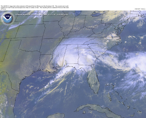
The storm remained parked over eastern Texas for several days, then moved eastward along the Gulf Coast, bringing welcome relief to residents of eastern Texas and southern Louisiana. However, this storm movement brought flooding and severe weather to our region on June 11. Satellite imagery from Monday, June 11th at 1215pm on the right shows the Allison over southeast Mississippi.
The outer rainbands produced 5-7 inches of rain to much of the area. The coastal counties of Alabama and across the northwest Florida panhandle were suffering from a moderate drought in previous few weeks, so the heavy rains from Allison caused localized flooding.
Allison brought damaging winds to much of the area, including at least 2 weak tornadoes. Most damage occurred in George County in southeast Mississippi and across Mobile and Covington Counties in southwest Alabama. Details about the impacts from Allison across those counties will be listed below.
George County, MS
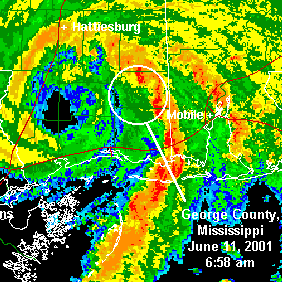 Radar imagery on the right shows the rainbands from Allison moving across George County in southeast Mississippi. The center of the low is clearly visible to the west of the county.
There were trees reported down in several locations throughout the county. The worst damage occurred in the southeast part of the county where an F1 tornado first touched down near Red Edwards Lane and Howell Road and moved north. When the tornado touched down, tree damage was noted with roof damage to a few of houses. As the tornado moved north, it crossed Griffin Lane and destroyed a newer manufactured home. The mobile home tie downs were pulled out of ground and the home turned over and fell apart as it rolled. A female at home when the tornado struck was injured and suffered a broken collarbone. The house was destroyed. The tornado then crossed Appaloosa Road and caused major damage to a 2-story house. The family was upstairs, saw the tornado coming and took shelter downstairs. They were not injured, but a portion of the roof and part of the room they were previously in were torn off. The tornado continued through the woods, crossing state Highway 612 just west of Walt Tanner Road. Trees were blown down and another house suffered roof damage. The tornado lifted near Sandy Hill Drive, where 4 manufactured homes were damaged with downed trees. The tornado path was 75 yards wide and 4 miles in length.
Other damage occurred west and south of Lucedale, MS with the most significant being along Inland Beach Road. Several homes suffered damage with a roof blown off a 2-story house. Numerous other houses suffered roof damage from high winds and trees falling. Numerous power lines were down across the area and trees were blown down at different locations all throughout the county. Some of the downed trees damaged roofs and high winds caused roof and outbuilding damage. Damage appeared to be from downburst winds. The time frame for most of the damage was from 650-715am.
Mobile County, AL
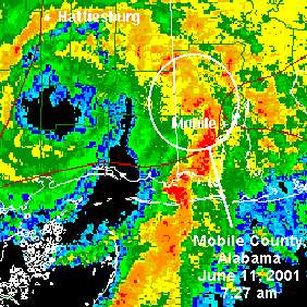 Radar imagery to the right shows Allison's rainband moving through Mobile County, AL. The stongest damage was reported in Semmes, AL, located in northwest Mobile County. In Semmes, high winds blew down trees with some trees landing on roofs of homes and vehicles. These high winds also caused roof and outbuilding damage. Most of the damage was off Highway 98 just west of Semmes. This damage appeared to be caused by downburst winds.
An F0 tornado first touched down in southwest Mobile County near Jeff Hamilton Road just east of Newman Road. The weak tornado moved across open fields and forest, moving across Newman Road near the Branson Subdivision. The tornado then moved through the subdivision blowing down several trees. Some homes were damaged from the fallen trees while others suffered roof damage from the high winds. The tornado then moved north and crossed Airport Boulevard just west of Newman Road. More trees were blown down with homes suffering damage from the trees and roof damage from the high winds. The tornado was approximately 50-75 yards wide and on the ground for about 2.5 miles.
Other locations throughout the county also had trees down and roof damage to houses . Most damage occurred between 700-800am.
Covington County, AL
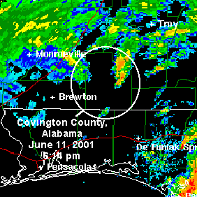 Radar imagery from the Covington County, AL area shows a much more diffuse storm structure on the right.
An F0 tornado first touched down on State Road 55 just south of Stanley, AL. 6 houses suffered roof damage with 2 outbuildings and a church also sustaining minor damage. The tornado tracked northeast crossing County Road 32 and County Road 34 just east of New Shady Grove Church. Trees were blown down in both of these areas. The tornado then lifted on the north side of County Road 34. The F0 tornado was approximately 50 yards in width and on the ground for about 3.5 miles.
A few locations throughout the county also had minor tree damage. Most of this tree damage occurred between 5:50 and 6:30pm.
NHC Advisory Archive
WPC Archive
NHC Tropical Cyclone Report - Tropical Storm Allison
NWS Service Assessment - Tropical Storm Allison
NWS Local Write-Ups and Webpages:
NWS Lake Charles, LA
NWS Houston/Galveston
Acknowledgements: Page updated by Morgan Barry (forecaster).
LAST UPDATED: November 2016

