August 2019 Climate Summaries
Mobile Alabama and Pensacola Florida Area
National Weather Service Mobile Alabama
September 5, 2019
August 2019 in Review - Monthly temperatures for the Mobile and Pensacola areas were very close to seasonal normal by a couple degrees. There were two records met, both occurring at Pensacola. Unusually, a record high and the other, a one day record rainfall that surpassed a 100 year old record both occurred on the 9th of the month. Beneficial August rainfall measured well above normal by several inches at both Mobile and Pensacola which helped cut into annual rainfall deficits.
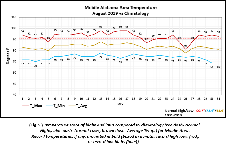
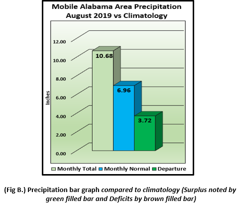
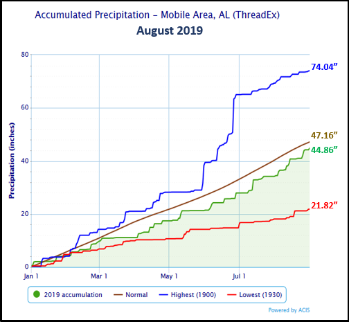
Mobile Alabama Area - The average monthly high of 92.7° was 2.0° above normal. The average monthly low of 74.2° was 1.6° above normal. The average monthly temperature of 83.4° was 1.8° above normal. (Fig. A) shows how the Mobile area temperatures compared to the seasonal normal monthly highs and lows, which are shown by the colored dashed lines. Total rainfall for August (Fig. B) measured 10.68" or 3.72" above normal. 2019's accumulated rainfall ending August 31st stands at 2.30" below seasonal normal.
Click on the Mobile Alabama area climate graphics below to expand:
|
|
Against Climatology |
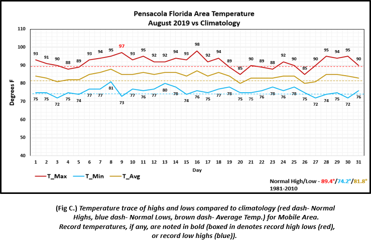
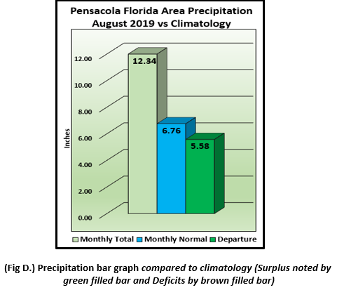
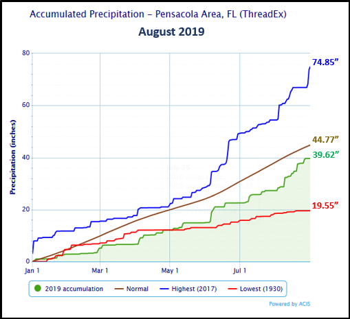
Pensacola Florida Area - The average monthly high of 91.8° was 2.4° above normal. The average monthly low of 75.8° was 1.6° above normal. The average monthly temperature of 83.8° was 2.0° above normal. One day saw two records, but the occurrence of both was quite unusual for a one day span. A record high earlier in the day on the 9th was soon followed by a record one day rainfall. A record high of 97° on the 9th broke the previous record of 96° set in 1941. Soon after, a thunderstorm dropped 3.55" of rainfall which surpassed the previous one day total rainfall record of 2.59" set 110 years earlier in 1909. (Fig. C) shows how the Pensacola area temperatures compared to the seasonal normal monthly highs and lows, which are shown by the colored dashed lines. Pensacola area rainfall (Fig. D) measured over a foot at 12.34" or 5.58" above normal. With the help of August rainfall, 2019's accumulated rainfall substantially reduced the annual deficit, now standing a little over 5 inches below the seasonal normal.
Click on the Pensacola Florida area climate graphics below to expand:
|
|
Against Climatology |
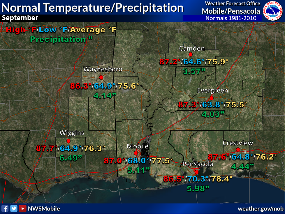
September Climatology and Outlooks:
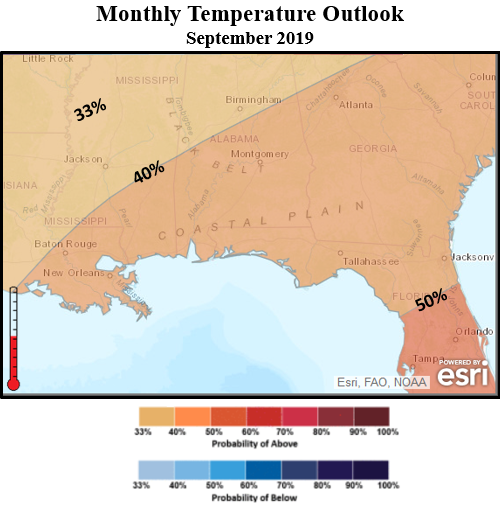
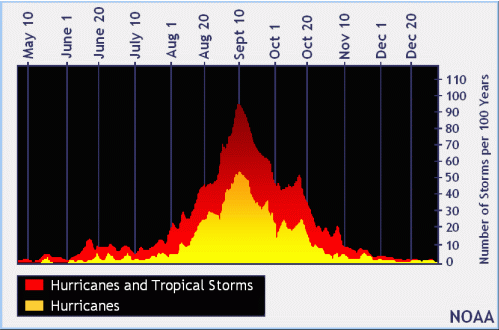
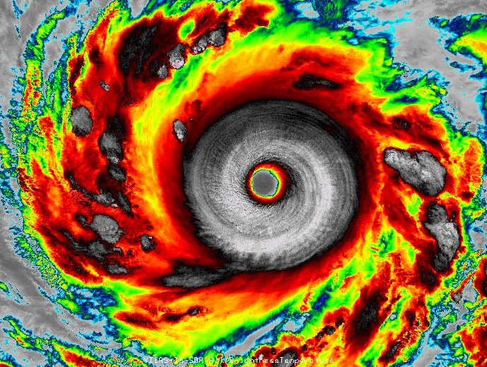
The long term weather outlook for September favors a continuation in the unseasonably warm weather pattern along the central Gulf coast while equal chances of above or below normal rainfall is favored. We continue through the climatological peak of tropical cyclone activity this month. NOAA announced back in August that the current El Niño in the Pacific Ocean has ended and neutral conditions have returned. “El Niño typically suppresses Atlantic hurricane activity but now that it’s gone, we could see a busier season ahead,” said Gerry Bell, Ph.D., lead seasonal hurricane forecaster at NOAA’s Climate Prediction Center. This evolution, combined with the more conducive conditions associated with the ongoing high-activity era for Atlantic hurricanes that began in 1995, increases the likelihood of above-normal activity this year.” Links to the outlook and tropical climatology are provided below.
Click on the snap shots below to expand:
|
Outlook |
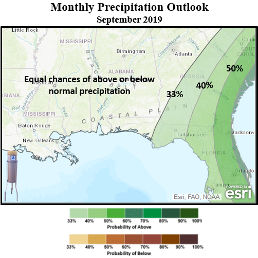
Outlook |
Climatology |
Hurricane Outlook |
|
Climate Prediction Center's Interactive Long Range Outlooks
Additional Climate Links:
The links below are intended to provide additional climate information, education and outlooks. The National Weather Service Mobile Alabama's Climate and Past Weatherpage provides climate data at your fingertips for many observation points in the local forecast area by accessing the NOWData tab as well as many other climate resources. The Climate Prediction Center Link provides short and longer range climatic outlooks and education about the larger scale global circulations that impact temperatures and weather. With the large agriculture and farming presence along the central Gulf coast, the Drought Monitor link provides updates on drought trends and impacts. Another very helpful resource is the Community Collaborative Rain Hail and Snow (CoCoRaHS) network, which is a large group of volunteers working together to measure and map precipitation (rain, hail and snow). The aim of CoCoRaHS is to provide the highest quality data for natural resource, education and research applications. You can be a part of the CoCoRaHS team by becoming a volunteer rainfall observer. To learn more click on the CoCoRaHS link below.
National Weather Service Mobile AL Climate and Past Weather
Climate Prediction Center (CPC)
CoCoRaHS Network Water Year Summaries