September 2019 Climate Summaries
Mobile Alabama and Pensacola Florida Area
Joe Maniscalco - Meteorologist/Forecaster/Climate Program Lead
National Weather Service Mobile Alabama
October 2, 2019
September 2019 in Review - It was a monumental record setting month along the central Gulf coast. An anomalously strong deep layer ridge, parked over the deep south, was responsible for multiple days of record heat. Monthly temperatures were well above seasonal normals. In fact, the average monthly high temperature for both the Mobile and Pensacola areas topped the record books as the warmest. The same can be said for the Pensacola area regarding the average temperature, while the average monthly temperature for the Mobile area was second warmest since records have been kept. Outside of the 19th over the Mobile area, rainfall was non-existent. The result is growing rainfall deficits and worsening drought conditions over the coastal plain.
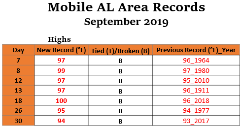
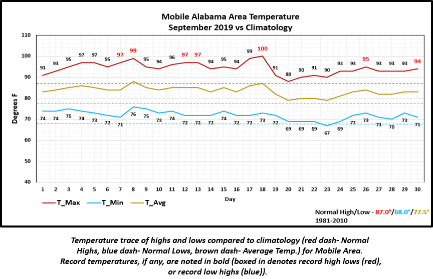
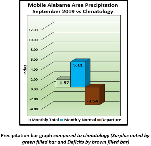
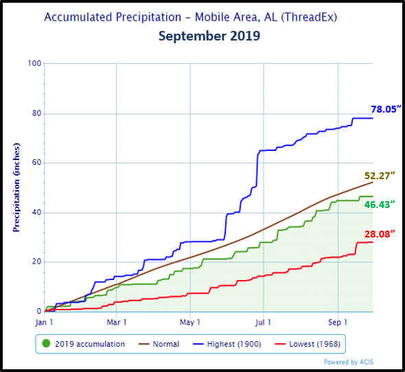
Mobile Alabama Area - The average monthly high of 94.3° was 7.3° above normal and now stands as the warmest on record. The average monthly low of 72.1° was 4.1° above normal. The average monthly temperature of 83.2° was 5.7° above normal and now ranks as 2nd warmest on record. (Fig. A) is a table listing all the record temperatures, whether they were met or exceeded and previous year of occurrence. All in all, 7 record temperatures were observed. (Fig. B) shows how the Mobile area temperatures compared to the seasonal normal monthly highs and lows, which are shown by the colored dashed lines. Total rainfall for September (Fig. C) measured a meager 1.57" or 3.54" below normal. 2019's accumulated rainfall ending September 30th (Fig. D) reflects an increase in the annual deficit to 5.84" below seasonal normal.
Click on the Mobile Alabama area climate graphics below to expand:
|
|
|
|
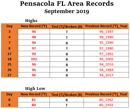
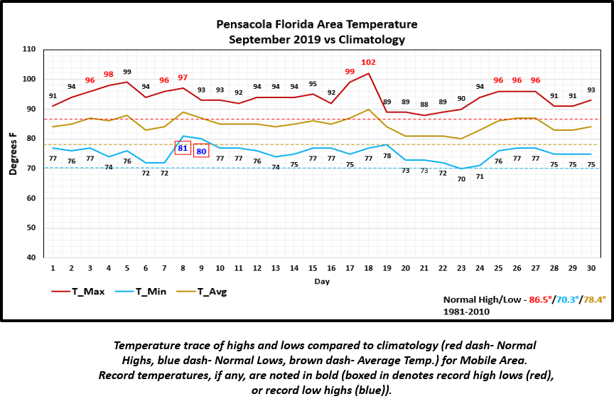
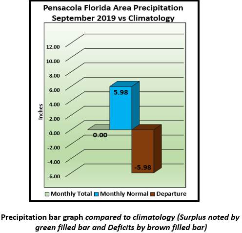
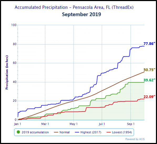
Pensacola Florida Area - The average monthly high of 93.8° was 7.3° above normal and stands as the warmest on record. The average monthly low of 75.4° was 5.1° above normal and stands at 5th warmest on record. The average monthly temperature of 84.6° was 6.2° above normal and stands as the warmest on record. (Fig. E) is a table listing all the record temperatures, whether they were met or exceeded and previous year of occurrence. A total of 11 record temperatures were observed. (Fig. F) shows how the Pensacola area temperatures compared to the seasonal normal monthly highs and lows, which are shown by the colored dashed lines. A stunning statistic is in the rainfall department (Fig. G). The rain gauge for the Pensacola area reported no measurable rain for the entire month or near a half foot below normal. 2019's accumulated rainfall ending September 30th (Fig. H) reflects a substantial increase in the annual deficit to just shy of a foot below seasonal normal. This has worsened the drought, which is now moderate in magnitude.
Click on the Pensacola Florida area climate graphics below to expand:
|
|
|
|
October Climatology and Outlooks:
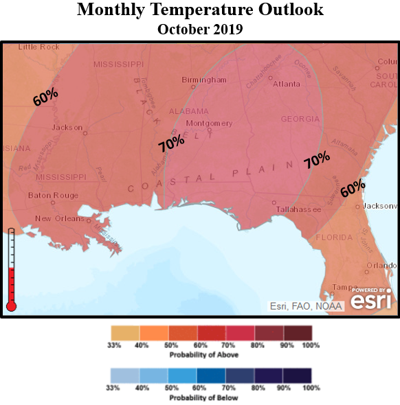
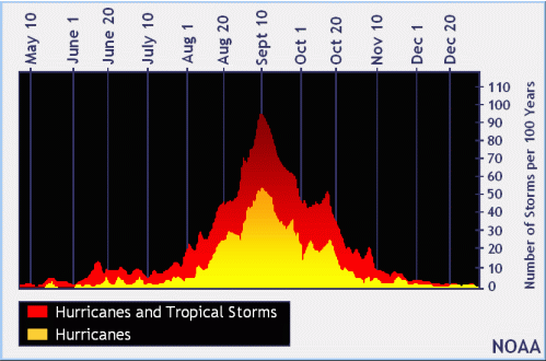
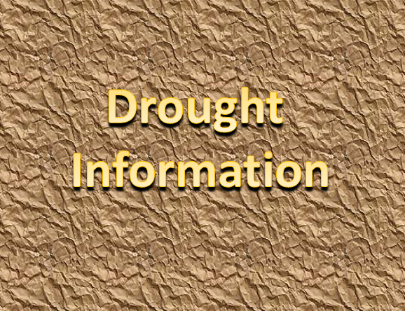
The probability of seeing above normal temperatures for October has increased with a large area of 60% probability and higher outlooked for the deep south. As far as lack of rainfall is concerned, which has caused drought conditions to worsen, we are moving into typically one of our driest months along the Gulf coast. Unfortunately, the long term weather outlook for rain during the month agrees; a large swath of below normal rain is favored over the coastal plain. Forecasters will continue to monitor the progression of drought and statements may become required if drought worsens further.
Click on the snap shots below to expand:
|
Outlook |

Outlook |
Climatology |

Hurricane Outlook |
|
Climate Prediction Center's Interactive Long Range Outlooks
Additional Climate Links:
The links below are intended to provide additional climate information, education and outlooks. The National Weather Service Mobile Alabama's Climate and Past Weatherpage provides climate data at your fingertips for many observation points in the local forecast area by accessing the NOWData tab as well as many other climate resources. The Climate Prediction Center Link provides short and longer range climatic outlooks and education about the larger scale global circulations that impact temperatures and weather. With the large agriculture and farming presence along the central Gulf coast, the Drought Monitor link provides updates on drought trends and impacts. Another very helpful resource is the Community Collaborative Rain Hail and Snow (CoCoRaHS) network, which is a large group of volunteers working together to measure and map precipitation (rain, hail and snow). The aim of CoCoRaHS is to provide the highest quality data for natural resource, education and research applications. You can be a part of the CoCoRaHS team by becoming a volunteer rainfall observer. To learn more click on the CoCoRaHS link below.
National Weather Service Mobile AL Climate and Past Weather
Climate Prediction Center (CPC)
CoCoRaHS Network Water Year Summaries
Questions or Comments:
Contact: Joe Maniscalco, WFO Mobile, AL at joe.maniscalco@noaa.gov