
A Nor'easter well off the East Coast will slowly track north this week and may gain some subtropical characteristics. Strong onshore winds will bring flooding, dangerous marine conditions, and beach erosion along the Mid-Atlantic coast. A Pacific storm is bringing gusty winds, severe thunderstorms, and mountain snow to portions of California and the Southwest U.S. through Thursday. Read More >
Overview
On August 7th, a robust system brought an environment supporting both individual thunderstorms as well as lines of thunderstorms to many areas across the eastern U.S. The strength of the system was extremely unusual for the month of August, producing a wind profile up through the atmosphere that was comparable to that of April and May. Low-level winds and overall wind shear were above and beyond nearby observed sounding climatology going back to the 1940s, combined with notable instability. Much of the area experienced widespread straight line wind damage, with estimated speeds ranging from 60 mph all the way up to 90 mph. The magnitude of the straight line winds was enough to cause structural damage in several locations, in addition to widespread downed trees and powerlines. This setup also produced an extremely rare August EF-2 tornado in western Knox County. This was only the 7th recorded August tornado in our 40-county forecast and warning area (records to the early 1900s) and only the 2nd EF-2 or greater tornado for the month of August in the area. The last time an August EF-2 occurred in our area was in 1964. This was also the first confirmed EF-2 or greater strength tornado in Knox County during any month of the year since February of 1993.
Tornado:
|
Tornado
Track Map 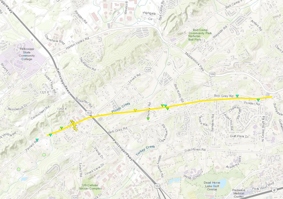 
|
||||||||||||||||
The Enhanced Fujita (EF) Scale classifies tornadoes into the following categories:
| EF0 Weak 65-85 mph |
EF1 Moderate 86-110 mph |
EF2 Significant 111-135 mph |
EF3 Severe 136-165 mph |
EF4 Extreme 166-200 mph |
EF5 Catastrophic 200+ mph |
 |
|||||
Photos & Video
NWS Surveys
 |
 |
 |
 |
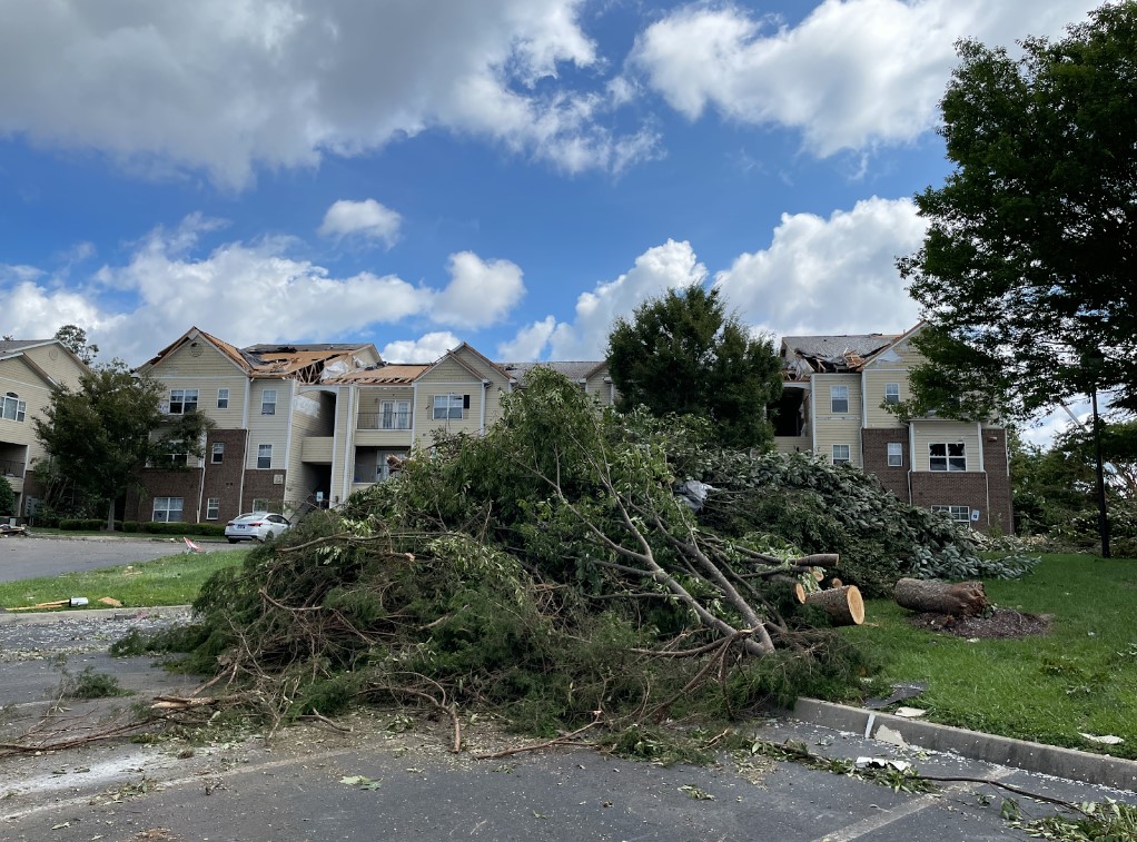
NWS Tornado Storm Damage Survey. Garage collapsed, rated at least 125 mph EF2
|
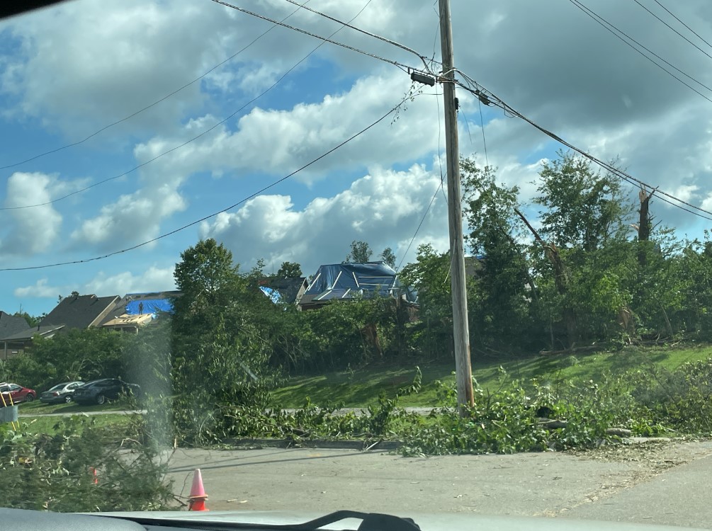
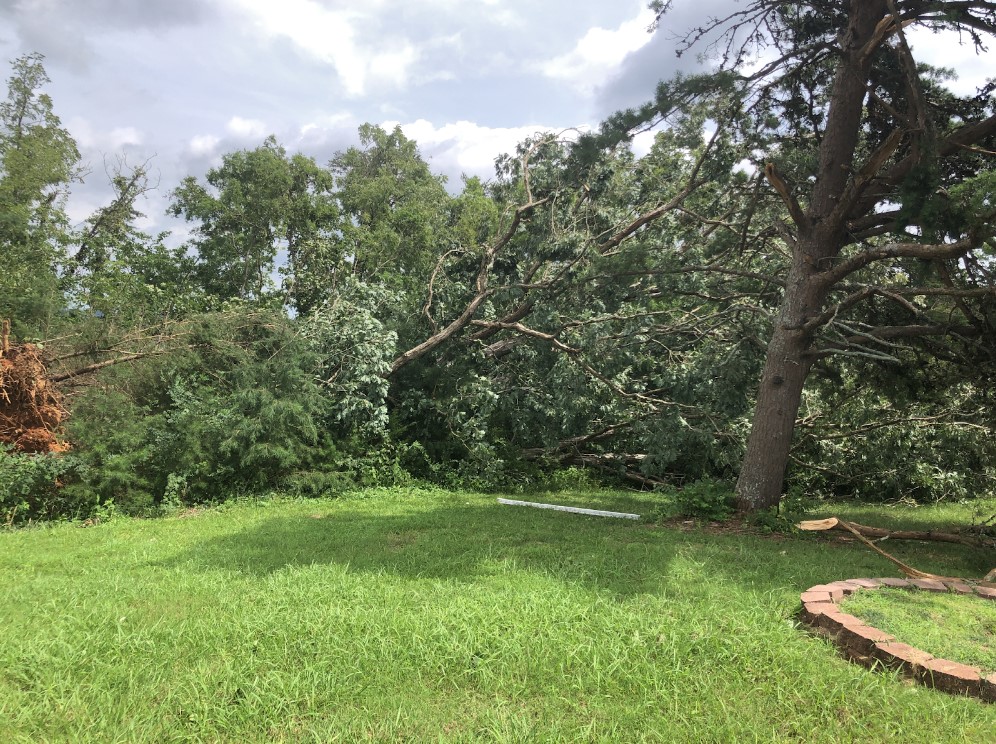
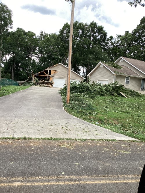
NWS Tornado Survey: Windows blown out with roof damage to apartments. Major tree damage, winds estimated at EF-2 130 mph | NWS Tornado Survey: Several homes with roof damage and lifted decking. Rated EF-1 at 105 mph | NWS Wind Damage Survey: Several large trees uprooted along Highway 321. Estimated winds of 60 mph |
 |
 |
 |
| NWS Wind Damage Survey: west of Dandridge, a large tree uprooted and collapsed a portion of the garage. Winds estimated at 80 mph | NWS Wind Damage survey: Metal roof of marina peeled and bent along Douglas Lake. Winds estimated at 80 mph | NWS Wind Damage Survey: A large tree was uprooted by estimated winds of ~90 mph in Sevier County |
Radar
 |
 |
 |
 |
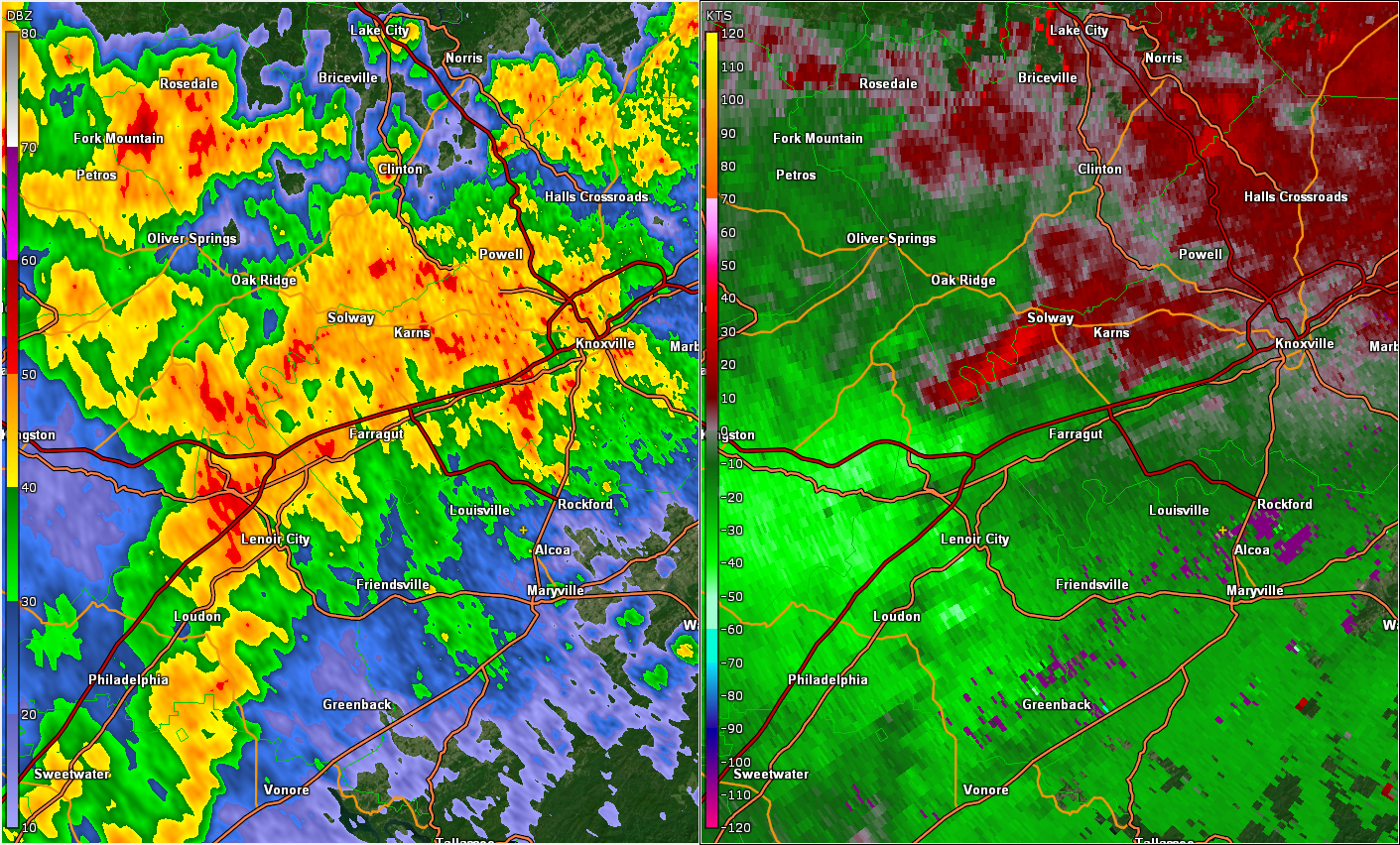
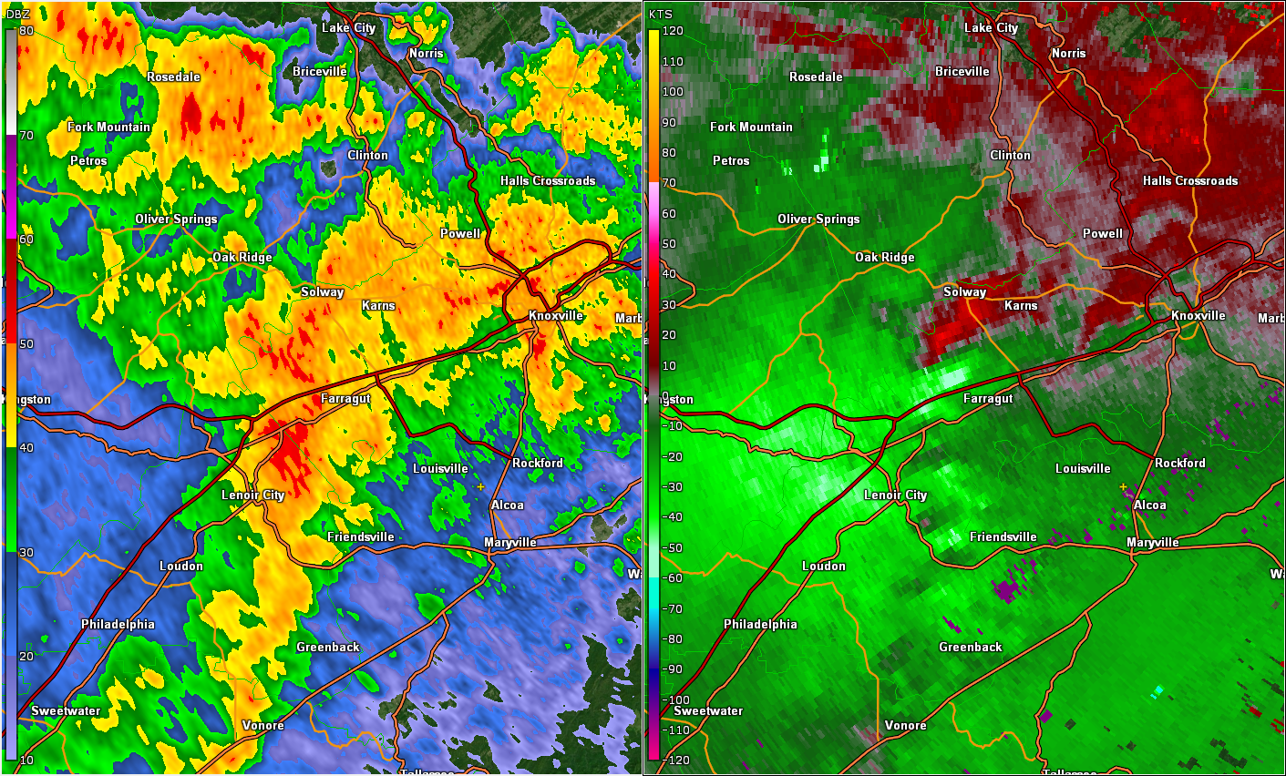
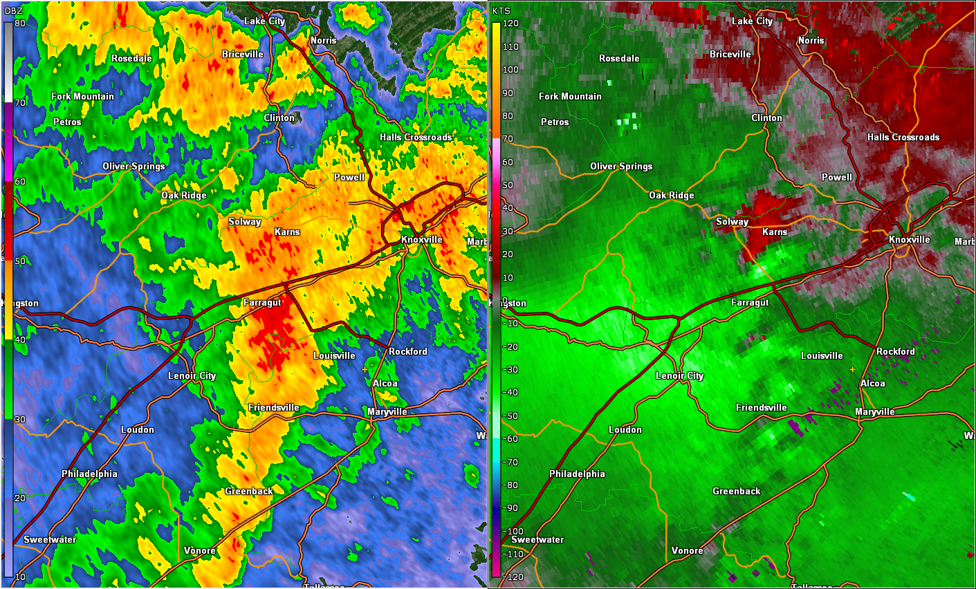
| Figure 1: Base Reflectivity and Storm Relative Velocity in Knox County at 1809 UTC | Figure 2: Base Reflectivity and Storm Relative Velocity in Knox County at 1813 UTC | Figure 3: Base Reflectivity and Storm Relative Velocity in Knox County at 1817 UTC | Figure 4: Base Reflectivity and Correlation Coefficient in Knox County at 1819 UTC |
The storm relative velocity in Figure 1 shows weak, broad rotation near the Knox/Anderson/Roane/Loudon county border. The reflectivity image on the right does not show the classic hook signature that is often associated with a tornado, but there is a subtle inflow notch in the back of the storm. This is the wedge of lower reflectivity values located along I-40 (red line) in eastern Roane County. This is a sign that high winds aloft are entering the rear of the storm and descending toward the ground.
The inbound (light green) velocities near Farragut, just north of I-40, have increased with this scan (Figure 2). The rotation signature is still broad, and the tornado has not yet formed. The inflow notch of lower reflectivity is located just west of Farragut and appears to be better defined than the previous image.
The inbound (green) and outbound (red) velocities have tightened, and the tornado has touched down at this time, crossing Pellissippi Parkway between Farragut and Karns (Figure 3).
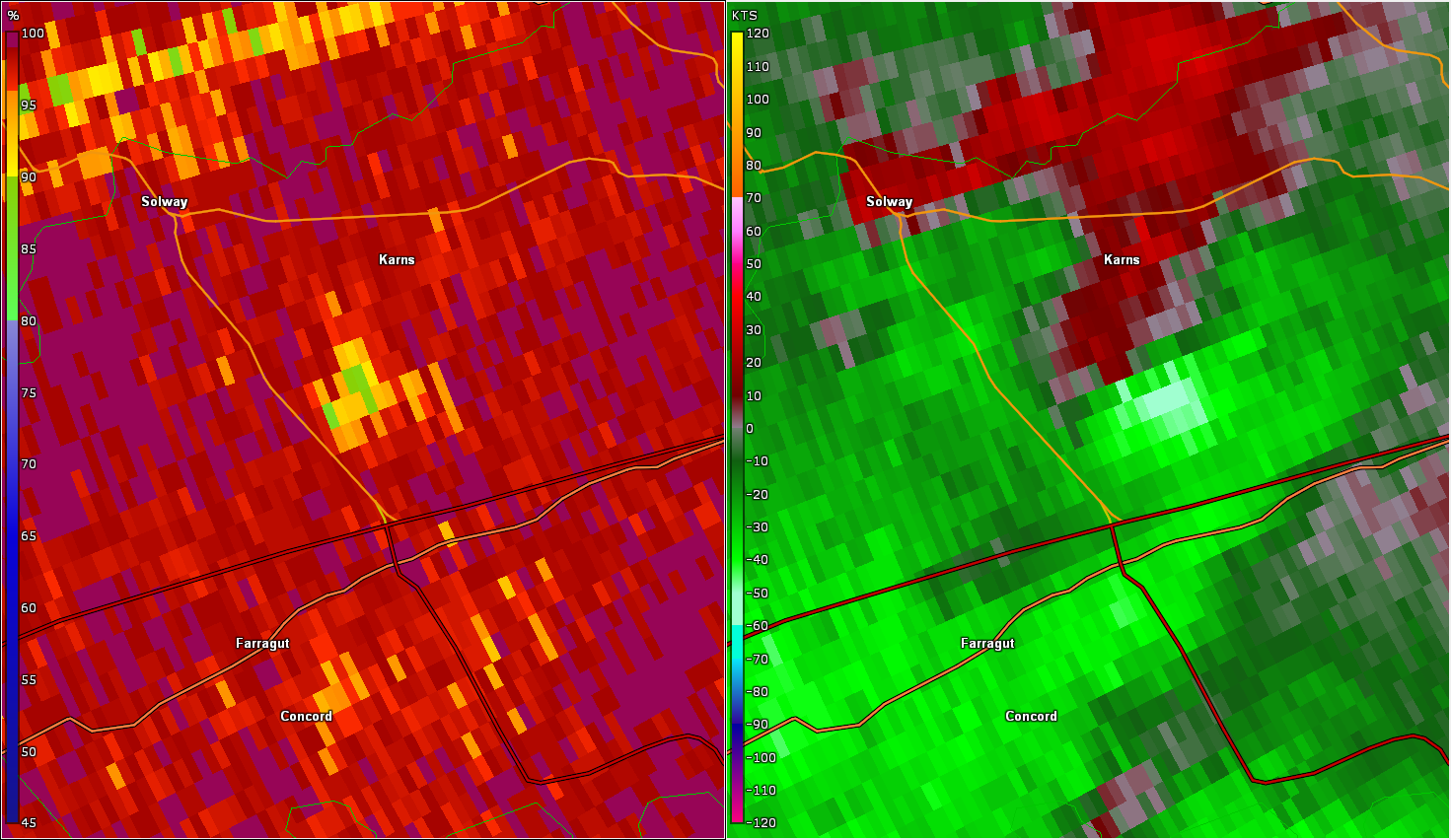
A closer look at the tornado radar signatures shows tight rotation in the velocity image on the right in Figure 4. The left image is Correlation Coefficient, which measures how many different size objects the radar is detecting. Lower CC values indicate many different sized objects. In this image, the green, yellow, and orange area south of Karns is likely debris that the tornado picked up and lofted into the air.
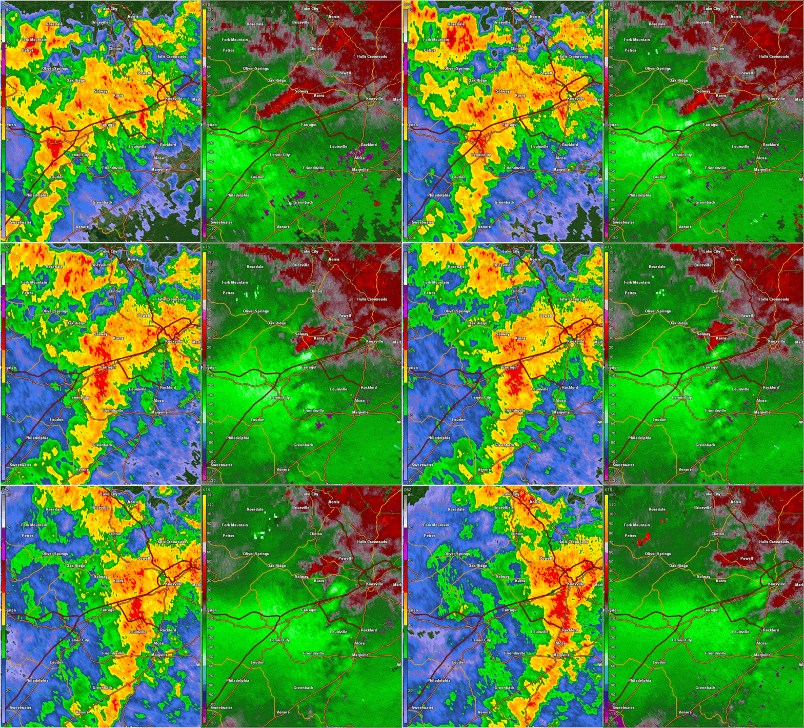 |
| Figure 5: Animation of Base Reflectivity and Storm Relative Velocity in Knox County |
Figure 5 is an animation of reflectivity and storm relative velocity of the Karns tornado. This was a very quick-forming and short-lived tornado, as it was on the ground for about five minutes. Base velocity showed widespread 80+ mph winds moving into Loudon and Knox County along the apex of this bowing severe thunderstorm.
 |
 |
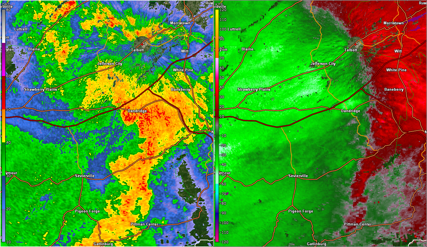 |
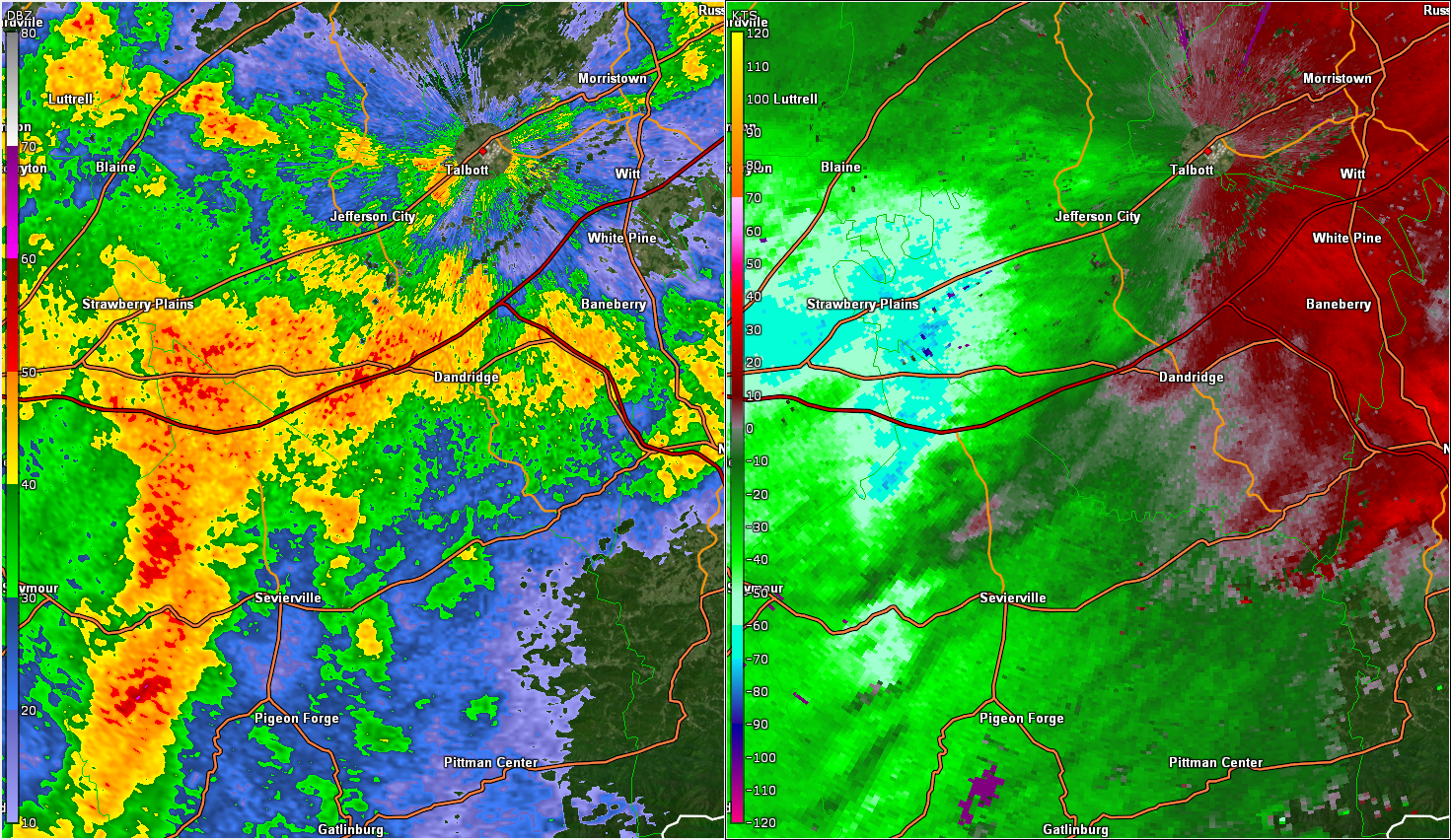
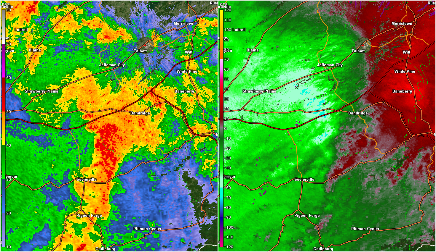
| Figure 6: Base Reflectivity and Storm Relative Velocity in Jefferson County at 1841 UTC | Figure 7: Reflectivity and Storm Relative Velocity in Jefferson County at 1849 UTC | Figure 8: Reflectivity and Storm Relative Velocity in Jefferson County at 1855 UTC |
As the storm moved out of Knox County, it produced straight-line wind damage farther east, in parts of Sevier and Jefferson counties near Douglas Lake. The velocity image on the right in Figure 6 shows winds moving toward the radar in northern Sevier County and western Jefferson County between 80 and 90 mph. However, winds of this speed were not yet reaching the ground. The radar beam is still located about one thousand feet above the ground at that location.
Damaging winds were occurring along Douglas Lake to the southwest of Dandridge at this time. Notice the strip of bright green to light blue colors crossing into Jefferson County, south of I-40 in Figure 7. In the reflectivity image on the left, there is a rear inflow notch just behind this area of higher velocities. This is a signature that high wind speeds aloft are entering the back of the storm and reaching the surface with the downdraft. Keep in mind that the radar measured wind speeds shown here are likely lower than the actual wind speed, because the radar can only accurately measure wind speeds that are directly toward or away from the radar. Winds that are parallel to the radar beam (from west to east near Douglas Lake, as in this case) will be underestimated. Based on a survey of the damage that occurred, wind speeds were estimated to be up to 85 mph.
The strength of the straight-line winds diminished on the east side of Dandridge, and the radar velocity image shows a drop in wind speeds in Figure 8. There were large tree limbs snapped as far as the I-40 bridge over Douglas Lake, but they were more sparse than on the west end of the lake.
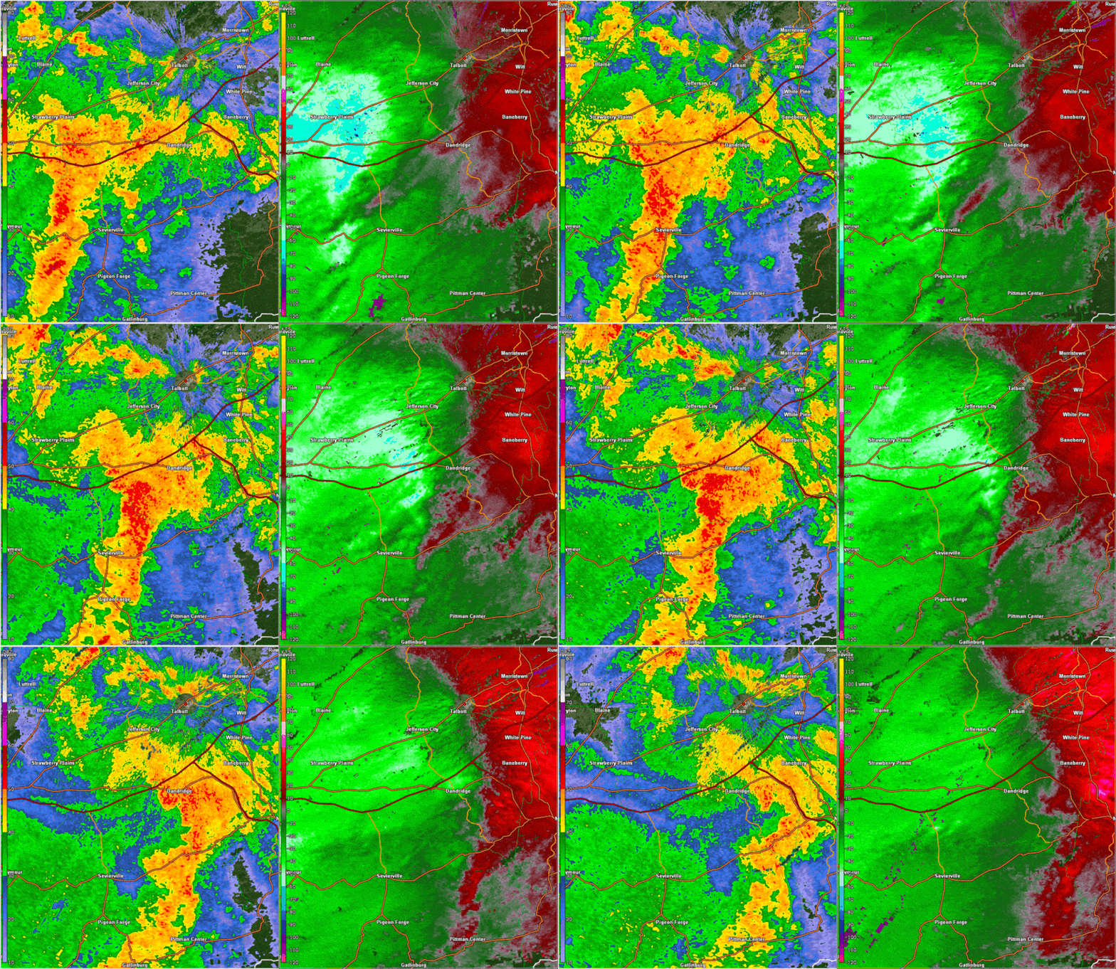 |
| Figure 9: Animation of Base Reflectivity and Base Velocity in Jefferson County |
Figure 9 is an animation of the reflectivity and radar-measured velocity of the storm that produced extensive straight-line wind damage near Douglas Lake.
Storm Reports
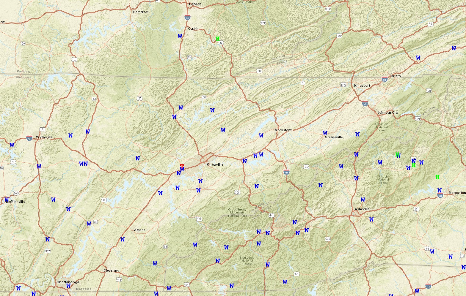
32 Total Reports: 31 for Damaging to Destructive Winds and 1 Tornado
W - Wind
H - Hail
T - Tornado
Public Information Statement
National Weather Service Morristown TN
403 PM EDT Tue Aug 8 2023 /303 PM CDT Tue Aug 8 2023/

...NWS Damage Survey for 08/07/2023 Tornado Event...

.Overview...A strong line of showers and thunderstorms
progressed northeast through the Tennessee valley Monday
afternoon, producing straight line winds in excess of 80
mph in some locations. As this line approached the Knoxville
metro area a brief tornado occurred, starting in roughly the
Hardin Valley area and proceeding east-northeast.

..4 SSW Karns Tornado...

Rating:                 EF2
Estimated Peak Wind:    130 mph
Path Length /statute/:  3.80 miles
Path Width /maximum/:   200 yards
Fatalities:             0
Injuries:               0

Start Date:             08/07/2023
Start Time:             02:17 PM EDT
Start Location:         4 SSW Karns / Knox County / TN
Start Lat/Lon:          35.9309 / -84.1587

End Date:               08/08/2023
End Time:               02:23 PM EDT
End Location:           3 SE Karns / Knox County / TN
End Lat/Lon:            35.9402 / -84.0924

Survey Summary:
The survey team started near the intersection of Yarnell Road and
North Campbell Station Road, and worked northeast along Yarnell in an
attempt to establish the starting location of the tornado. Significant
tree damage became apparent between Chapes Lane and Lamons Quarry Lane
but this did not appear to be tornadic. The tornado started slightly
further east on Yarnell, then reached peak intensity and width as it
passed Paideia Academy, Lovell Cove subdivision, and the Lovell
Crossing apartment complex. Significant roof damage was noted to several
of the homes in Lovell Cove as well as several buildings in Lovell
Crossing. In addition to roof damage, a complete collapse of a garage
or storage at Lovell Crossing was noted, along with wooden boards
driven into the ground and a large gash in the side of apartment complex
office from the impact of a large, but unknown object. The tornado then
continued east of Pellissippi Parkway, along and north of Bob Gray Road.
Additional significant tree damage was seen off Hickey Road between
Bob Gray and Wellington West Drive. The survey crew was unable to view
much in the vicinity of Bob Kirby Lane and Bob Gray Road due to road
obstructions and utility crew work but there was extensive tree damage
in that area. The tornado appears to have dissipated at the intersection
of Bob Gray Road and Middlebrook Pike. There was scattered, sometimes
intense, tree damage further east, but it was not consistent with tornadic
damage.
Public Information Statement
National Weather Service Morristown TN
442 PM EDT Tue Aug 8 2023

...NWS Damage Survey for August 7, 2023 Thunderstorm Wind Event
In Sevier and Jefferson Counties...

.Overview...A line of thunderstorms tracked east across central
East Tennessee during the afternoon, producing extensive wind
damage in Knoxville. As this line continued east, it produced
a swath of wind damage along the northern shore of Douglas Lake.

.Sevier and Jefferson County Thunderstorm Wind...

Estimated Peak Wind:    85 mph
Path Length /statute/:  12 miles
Fatalities:             0
Injuries:               0

Start Date:             August 7, 2023
Start Time:             245 pm EDT
Start Location:         Kodak, TN
Start Lat/Lon:          35.97, -83.58

End Date:               August 7, 2023
End Time:               300 pm EDT
End Location:           4 miles ENE of Dandridge, TN
End Lat/Lon:            36.04, -83.35

The survey began in Kodak, TN, at Winfield Dunn Parkway and
Highway 139 in Sevier County. Damage was found in the Splendor
Oaks subdivision off Highway 139. Several large tree limbs were
snapped, with a large tree uprooted and another large tree
snapped at the trunk, all facing east. Tree damage was sporadic
along Highway 139, with an area of greater damage located near
Overlook RV Park. Two metal RV canopies were torn from their
anchors and blown several yards, and an RV was shifted off its
blocks. Multiple trees were snapped and uprooted along Glenbook
Lane, one falling onto house. At Lighthouse Pointe Marina,
the docks were shifted and the metal awning was peeled back in
several places. Many trees were snapped and uprooted in a
neighborhood along Morie Road and Economy Circle, some falling
onto homes or garages. Around Dandridge, numerous trees were
snapped or uprooted, particularly near Maury School. All the
trees had fallen toward the east or southeast. Sporadic tree
damage, mainly snapped large branches, continued along
Highway 25/70 and in the Burchfield Road area, ending before
the I-40 bridge across Douglas Lake.
Public Information Statement
National Weather Service Morristown TN
442 PM EDT Tue Aug 8 2023

...NWS Damage Survey for August 7, 2023 Thunderstorm Wind Event
In Sevier and Jefferson Counties...

.Overview...A line of thunderstorms tracked east across central
East Tennessee during the afternoon, producing extensive wind
damage in Knoxville. As this line continued east, it produced
a swath of wind damage along the northern shore of Douglas Lake.

.Sevier and Jefferson County Thunderstorm Wind...

Estimated Peak Wind:    85 mph
Path Length /statute/:  12 miles
Fatalities:             0
Injuries:               0

Start Date:             August 7, 2023
Start Time:             245 pm EDT
Start Location:         Kodak, TN
Start Lat/Lon:          35.97, -83.58

End Date:               August 7, 2023
End Time:               300 pm EDT
End Location:           4 miles ENE of Dandridge, TN
End Lat/Lon:            36.04, -83.35

The survey began in Kodak, TN, at Winfield Dunn Parkway and
Highway 139 in Sevier County. Damage was found in the Splendor
Oaks subdivision off Highway 139. Several large tree limbs were
snapped, with a large tree uprooted and another large tree
snapped at the trunk, all facing east. Tree damage was sporadic
along Highway 139, with an area of greater damage located near
Overlook RV Park. Two metal RV canopies were torn from their
anchors and blown several yards, and an RV was shifted off its
blocks. Multiple trees were snapped and uprooted along Glenbook
Lane, one falling onto house. At Lighthouse Pointe Marina,
the docks were shifted and the metal awning was peeled back in
several places. Many trees were snapped and uprooted in a
neighborhood along Morie Road and Economy Circle, some falling
onto homes or garages. Around Dandridge, numerous trees were
snapped or uprooted, particularly near Maury School. All the
trees had fallen toward the east or southeast. Sporadic tree
damage, mainly snapped large branches, continued along
Highway 25/70 and in the Burchfield Road area, ending before
the I-40 bridge across Douglas Lake.
Preliminary Local Storm Report...Summary
National Weather Service Morristown TN
852 PM EDT Mon Aug 7 2023

..TIME...   ...EVENT...      ...CITY LOCATION...     ...LAT.LON...
..DATE...   ....MAG....      ..COUNTY LOCATION..ST.. ...SOURCE....
            ..REMARKS..

0125 PM     Tstm Wnd Dmg     2 WSW Luttrell          36.20N 83.77W
08/07/2023                   Union              TN   911 Call Center

            A few trees down.

0130 PM     Tstm Wnd Dmg     Dunlap                  35.38N 85.39W
08/07/2023                   Sequatchie         TN   911 Call Center

            Numerous trees and power lines down across
            the county.

0145 PM     Tstm Wnd Dmg     Dayton                  35.50N 85.01W
08/07/2023                   Rhea               TN   Public

            Large tree down.

0145 PM     Tstm Wnd Dmg     Oakdale                 35.99N 84.56W
08/07/2023                   Morgan             TN   911 Call Center

            Numerous trees and power lines down across
            the southern portion of the county.

0205 PM     Tstm Wnd Dmg     Riceville               35.38N 84.70W
08/07/2023                   McMinn             TN   911 Call Center

            Multiple trees and power lines down.

0210 PM     Tstm Wnd Dmg     Athens                  35.45N 84.60W
08/07/2023                   McMinn             TN   911 Call Center

            Multiple trees and power lines down.

0155 PM     Tstm Wnd Dmg     3 E South Pittsburg     35.01N 85.66W
08/07/2023                   Marion             TN   Emergency Mngr

            Multiple trees down in New Hope.

0150 PM     Tstm Wnd Dmg     Farragut                35.88N 84.18W
08/07/2023                   Knox               TN   911 Call Center

            Several trees and power lines down.

0200 PM     Hail             Jefferson City          36.12N 83.49W
08/07/2023  E0.25 inch       Jefferson          TN   Public


0210 PM     Tstm Wnd Dmg     Dandridge               36.02N 83.42W
08/07/2023                   Jefferson          TN   Amateur Radio

            Multiple trees and power lines down. Trees
            down on vehicles, and on homes.

0130 PM     Tstm Wnd Dmg     1 NNW Talbott           36.16N 83.42W
08/07/2023                   Hamblen            TN   Public

            Large tree down.

0131 PM     Tstm Wnd Dmg     Morristown              36.22N 83.30W
08/07/2023                   Hamblen            TN   Public

            Numerous trees down in Morristown.

1209 PM     Tstm Wnd Dmg     2 S Caryville           36.30N 84.22W
08/07/2023                   Campbell           TN   911 Call Center

            A few trees down.

1249 PM     Tstm Wnd Dmg     2 WSW La Follette       36.37N 84.16W
08/07/2023                   Campbell           TN   911 Call Center

            A few trees down.

0130 PM     Tstm Wnd Dmg     Pikeville               35.61N 85.20W
08/07/2023                   Bledsoe            TN   911 Call Center

            Numerous trees and power lines down
            countywide.
Environment
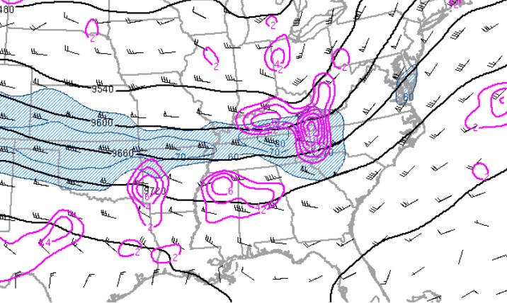
The North American Ensemble Forecast System (NAEFS) table allows forecasters to determine if the storm system is stronger than climatology. The NAEFS depicted a much stronger jet and associated upper dynamics with the storm system on August 7th 2023. In some cases, the strength of the jet was 5 to 6 standard deviations above climatology.
An anomaly strong upper and lower level jet across the Tennessee and lower Ohio Valley moved into the southern Appalachians during the afternoon and produced large-scale forcing over the area.
 |
 |
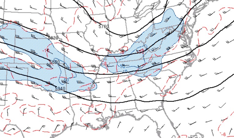 |
| Figure 1: NAEFS Mean Wind Speed (kt) and Standardized Anomaly | Figure 2: 300mb Heights, Divergence, and Winds at 1800 UTC | Figure 3: 500mb Heights, Temperature, and Winds at 1800 UTC |
The 300mb analysis showed divergence aloft over east Tennessee and southwest Virginia which aided in the development and organization of the storms.
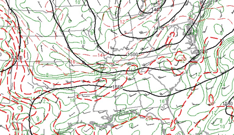
The upper forcing enhanced the boundary layer jet over the eastern Tennessee valley and southern Appalachians with southwest winds of 40-45 kts. This low level jet pulled abundant moisture and instability into the central and southern Appalachians. For August, the strength of these winds are quite unusual and 2 to 3 deviations above climatology norms.
 |
 |
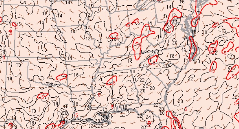 |
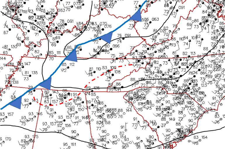
| Figure 4: 850mb Heights, Temperature, and Winds at 1800 UTC | Figure 5: Surface Station Plot at 1800 UTC | Figure 6: Surface Moisture Convergence and Mixing Ratio at 1800 UTC |
The surface analysis at 1800Z, August 7th 2023 showed a strong frontal boundary moving toward east Tennessee and southwest Virginia (denoted in blue) with an outflow boundary from storms across the Plateau and southeast Kentucky moving south and east across the region.
Warm and moist conditions were noted south of the boundary across Tennessee with temperatures in the 80s and dewpoints in the 70s, cooler air over the midwest north of the boundary. The outflow boundary along with the incoming cold front produced a convergent wind field that helped to focus the severe storms.
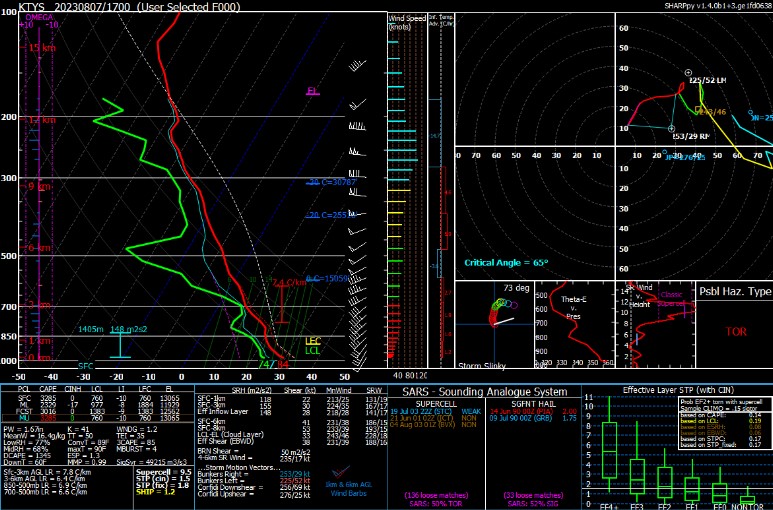 |
| Figure 7: RAP Initialization Sounding at KTYS (Knoxville TN) at 1800 UTC |
The KTYS (Knoxville Tennessee) RAP initialization soundings at 18 UTC, 7 August 2023 was utilized to diagnose the environment across east Tennessee, specifically near the Knox County, Tennessee tornado.
The soundings depicted an unstable environment with Mixed Layer CAPE of 2300 J/Kg and low-level CAPE of 85 J/Kg. Lifting Condensation Level (LCL) of 900-1000 meters. The effective storm scale shear was near 40 knots with the 0-1 km shear over 20 knots. Overall, an environment conducive for tornadic storms. The 0-3 km shear near 30 knots increased to 40 to 45 knots during the afternoon which heightened the risk of Quasi-Linear Convective Storms mesovortices.
 |
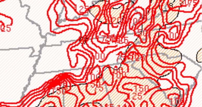 |
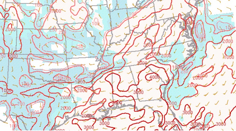
| Figure 8: MLCAPE and CIN at 1800 UTC | Figure 9: 0-3 km MLCAPE and Surface Vorticity at 1800 UTC |
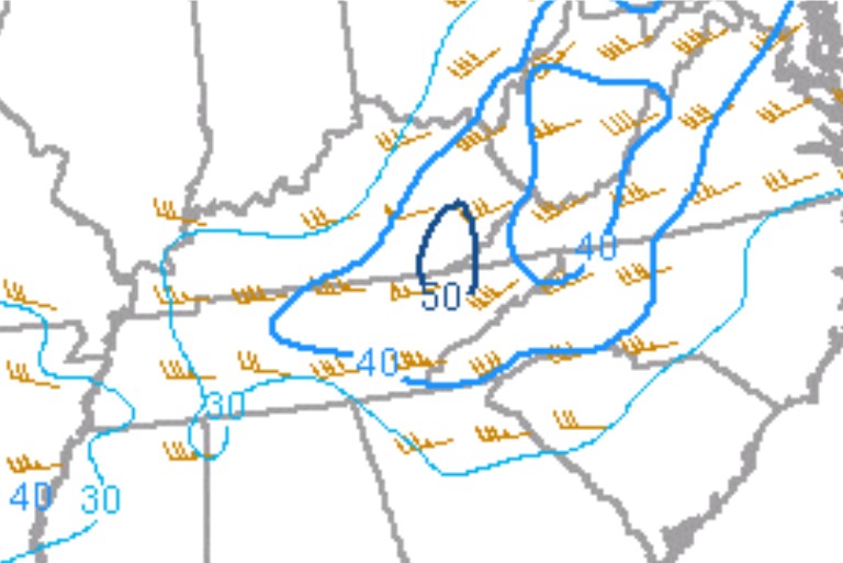
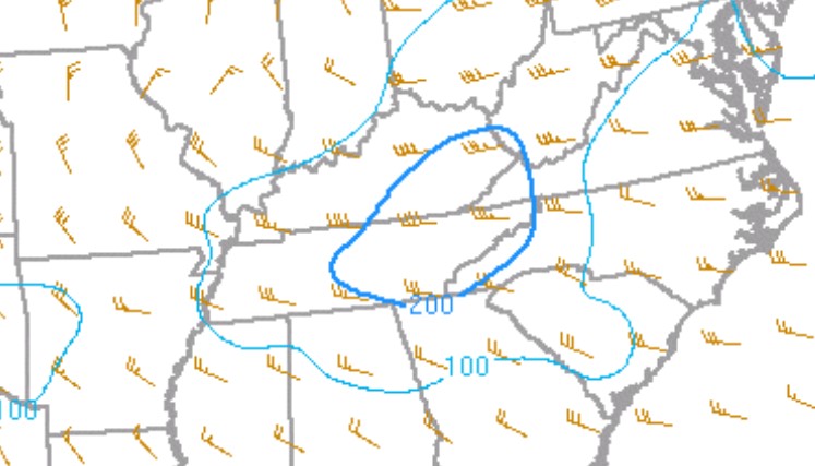
The SPC mesoanalysis depicted an unstable environment with MLCAPES of 2000-3000 J/Kg across much of southwest Virginia, east Tennessee and southwest North Carolina. As noted above the 0-3 km MLCAPE was quite high with values of 100-150.
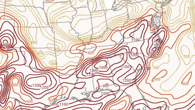
The greatest overall threat of high-end damaging winds were due to downdraft CAPES of 1000-1300 J/Kg and a low-level jet up to 40 to 50 knots. The combination of these environmental factors produced very high Derecho Composite Parameter (DCP) values of 8 to 10+. High DCP values denoted a heightened probability of significant wind damage capable of producing widespread down trees and power lines, along with the potential of structural damage.
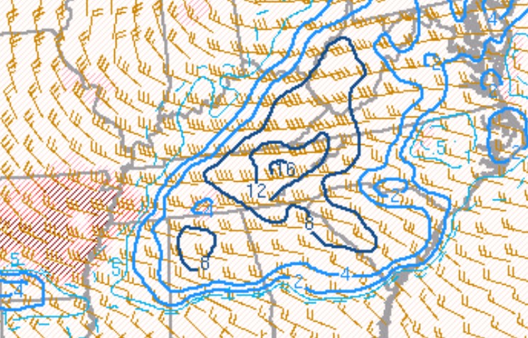
The Supercell Composite Parameter (SCP) near 16 and Significant Tornado Parameter of 3 to 4 depicted an overall very favorable environment for rotating storms and potential of tornadoes across much of the area.
 |
 |
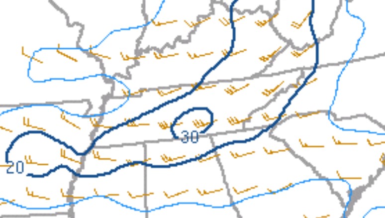 |
| Figure 10: DCAPE and DCIN at 1800 UTC | Figure 11: Effective Shear at 1800 UTC | Figure 12: 0-1 km Shear at 1800 UTC |
|
 |
Media use of NWS Web News Stories is encouraged! Please acknowledge the NWS as the source of any news information accessed from this site. |
|



 Local Radar
 Huntsville Radar
 Regional Satellite
 Graphical Forecast
 Weather Map
 Follow us on X
 Follow us on Facebook
 Follow us on YouTube
 MRX RSS Feed