
Widespread life-threatening flash and urban flooding continues in south-central Texas, with considerable flooding impacts possible across central Texas. Wildfire smoke is impacting air quality across much of the Great Lakes region into southern New England and the Mid-Atlantic. Monsoonal thunderstorms may produce isolated to scattered flash flooding across the Southwest into the Great Basin. Read More >
Overview
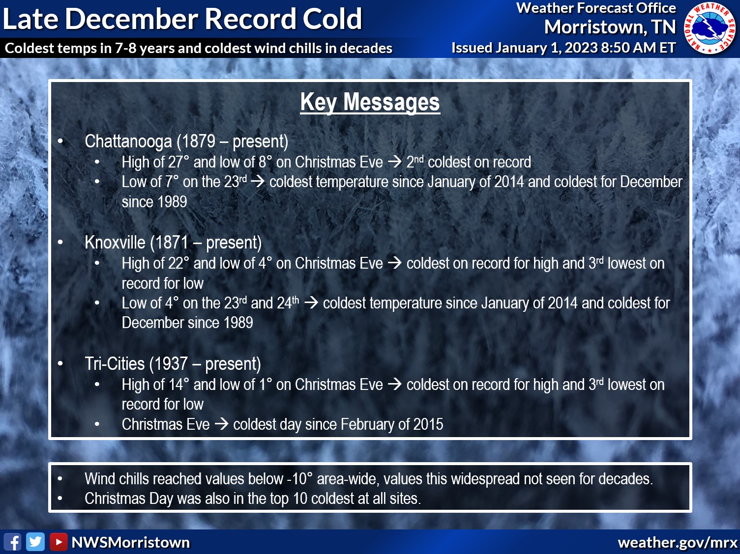
On the morning of December 23rd, an extreme arctic cold front moved through the region, leading to record-breaking temperatures and wind chills in the double- digits below 0 due to frequent wind gusts above 30 mph. Power outages, due to both rolling blackouts and the winds, and loss of running water in many places were experienced in many locations across the region. Temperatures on Christmas Eve were among the coldest on record for both high and low temperatures with a very slow warming trend in the days afterward. The wind chills that resulted were the coldest in most places since February of 1996.
Climatological Significance and Photos
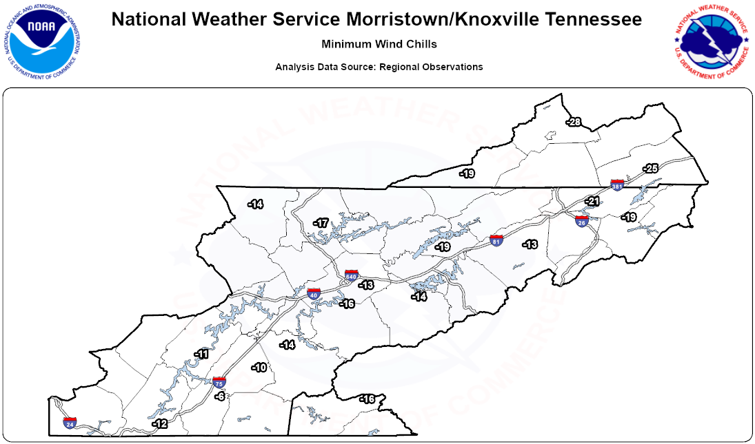
Tabular Winds and Wind Chills
*"None" denotes that data is missing at the station during the specified time, often due to a communication outage
| Station ID | Day | Minimum Temperature | Average Wind Chill | Minimum Wind Chill | Max Wind Gust (mph) |
| 0A9 | 12/23/2022 | 1 | 0 | -19 | 44 |
| RKW | 12/23/2022 | 0 | -12 | -18 | 40 |
| OQT | 12/23/2022 | 3 | -4 | -12 | 46 |
| GCY | 12/23/2022 | 5 | 3 | -13 | 40 |
| MOR | 12/23/2022 | 1 | -5 | -17 | 43 |
| CSV | 12/23/2022 | -4 | -21 | -27 | 45 |
| SCX | 12/23/2022 | 19 | None | 6 | 31 |
| GKT | 12/23/2022 | 5 | -2 | -14 | 38 |
| MNV | 12/23/2022 | 5 | -4 | -14 | 45 |
| TYS | 12/23/2022 | 4 | -6 | -15 | 50 |
| 2A0 | 12/23/2022 | 7 | -3 | -11 | 35 |
| JAU | 12/23/2022 | 1 | -6 | -17 | 29 |
| TRI | 12/23/2022 | 2 | -3 | -21 | 51 |
| CHA | 12/23/2022 | 7 | -1 | -12 | 43 |
| RZR | 12/23/2022 | 9 | None | -6 | 23 |
| MMI | 12/23/2022 | 5 | 0 | -10 | 36 |
| DKX | 12/23/2022 | 7 | 1 | -13 | 41 |
| MMI | 12/24/2022 | 3 | 7 | -8 | 16 |
| RKW | 12/24/2022 | 0 | -13 | -17 | 17 |
| MNV | 12/24/2022 | 5 | 3 | -11 | 18 |
| TYS | 12/24/2022 | 4 | -3 | -16 | 26 |
| MOR | 12/24/2022 | 1 | -5 | -19 | 26 |
| OQT | 12/24/2022 | 4 | 5 | -8 | 22 |
| TRI | 12/24/2022 | 1 | -7 | -20 | 31 |
| CSV | 12/24/2022 | -2 | -7 | -20 | 26 |
| DKX | 12/24/2022 | None | None | None | None |
| 2A0 | 12/24/2022 | 7 | 6 | -9 | 21 |
| SCX | 12/24/2022 | 1 | -3 | -14 | 23 |
| GCY | 12/24/2022 | None | None | None | None |
| 0A9 | 12/24/2022 | 1 | -15 | -18 | 28 |
| GKT | 12/24/2022 | 3 | 1 | -14 | 26 |
| RZR | 12/24/2022 | None | None | None | None |
| JAU | 12/24/2022 | 1 | 2 | -14 | 22 |
| CHA | 12/24/2022 | 8 | 6 | -5 | 24 |
Environment
 |
 |
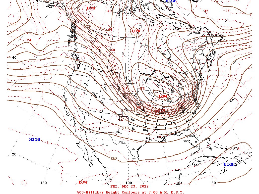 |
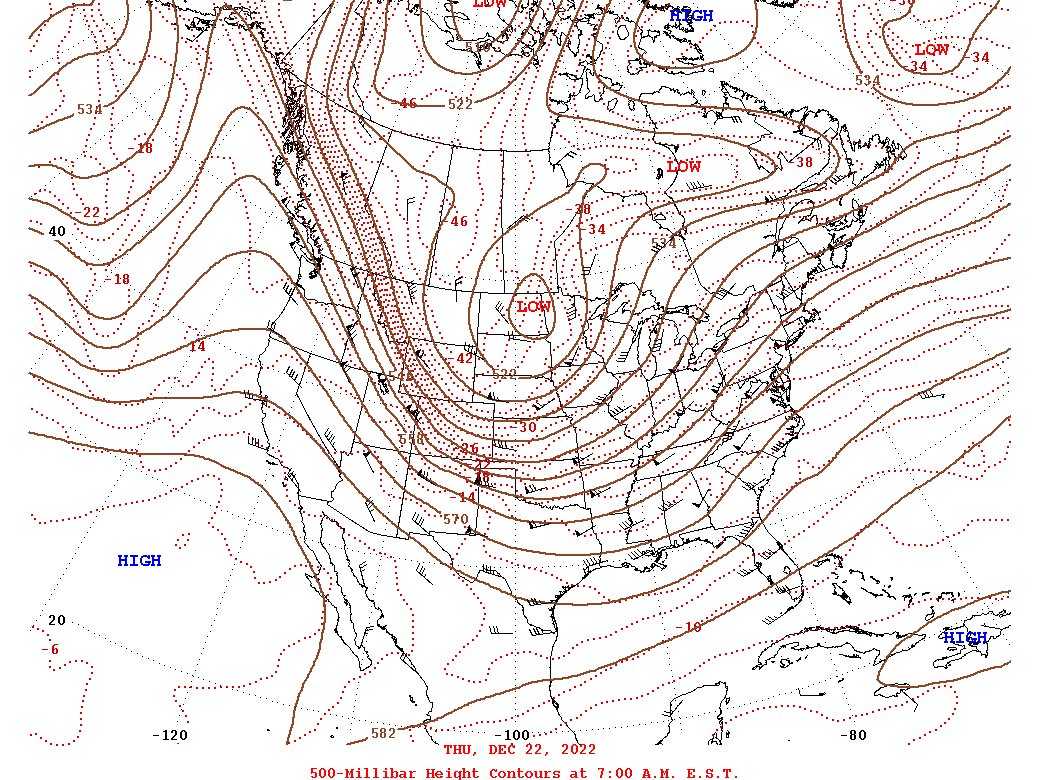
| Figure 1: 300mb Wind Speeds | Figure 2: 500mb Heights, Winds and Temperatures Before Event | Figure 3: 500mb Heights, Winds, and Temperatures During Event |
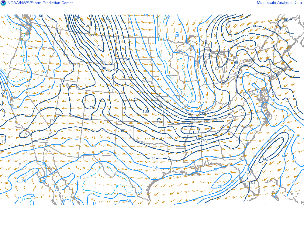
Figure 1 shows the wind speeds at 300 mb, which is the height of the jet stream. The strongest core of the jet stream stretches from Tennessee to Montana and western Canada, bringing extremely cold air into the Southeast. Meanwhile, another jet is located over the eastern Great Lakes and eastern Canada. The area where two jets interact is often a favored area for low pressure systems to strengthen. This jet structure and the strength of the jets were significant factors in the rapid intensification of the surface low pressure system near the Great Lakes.
Figure 3 shows 500 mb heights, winds, and temperatures at 7 am EST Friday with Figure 2 depicting this the morning of Thursday. The low over the Great Lakes region was connected to a trough over far northwestern Canada, and as the low dropped southeast, it brought a cold air mass with arctic origins much farther south than normal.
 |
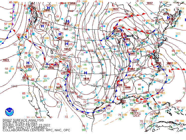 |
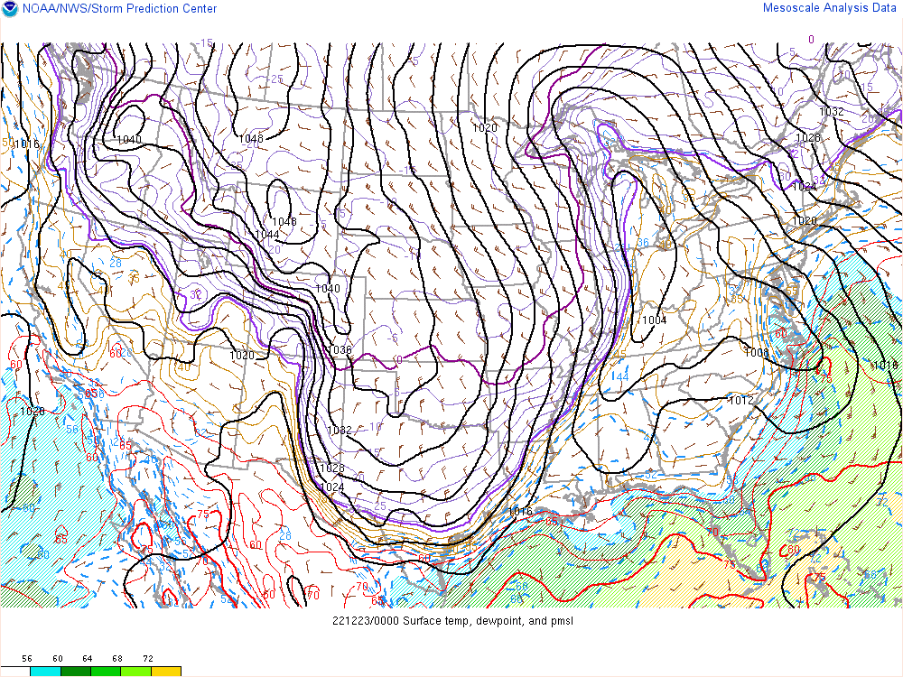
| Figure 4: Animation of MSLP, Surface Temperatures, and Dew Points | Figure 5: WPC Surface Analysis |
This animation of surface temperature and pressure in Figure 4 shows the passage of the strong cold front through East Tennessee between 1 am and 7 am EST Friday morning, with extremely cold air ushering into the area through Friday morning. The rapid drop in pressure as the system intensified resulted in a very strong pressure gradient between the low near the Great Lakes and a high pressure system over the central and southern Plains, which was about 1043 mb on Friday afternoon. The tight pressure gradient produced the strong winds in East Tennessee. The combination of extremely cold temperatures and high winds is what made this weather event unique and hazardous.
An interesting feature of this event was the merger of two low pressure systems that led to the formation of one very strong system, shown in Figure 5. At the start of this animation, there is a weak low pressure system over eastern North Carolina, which tracks northward and strengthens. It merges with another low pressure system over the UP of Michigan, which tracks slowly eastward and strengthens. These two systems merge over western New York around 7 am EST Friday morning, resulting in a very intense low with a pressure of 974 mb at 1 pm EST Friday.
 |
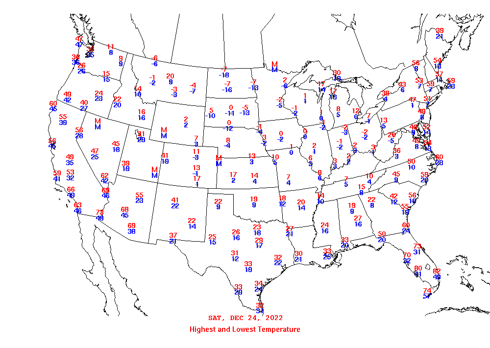 |
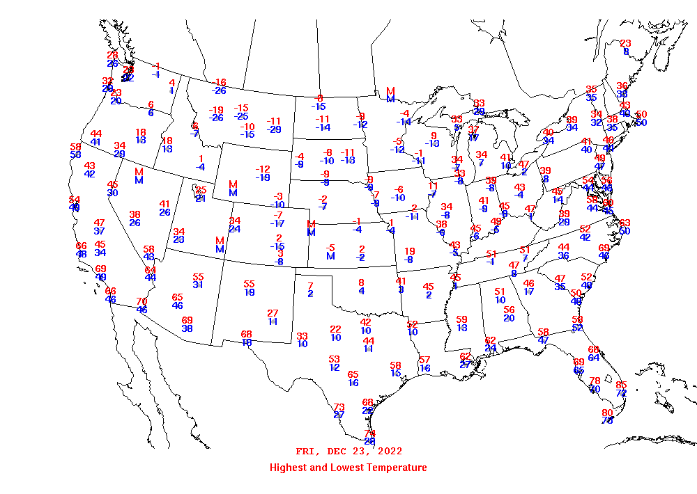
| Figure 6: High and Low Temperatures on December 23rd | Figure 7: High and Low Temperatures on December 24th |
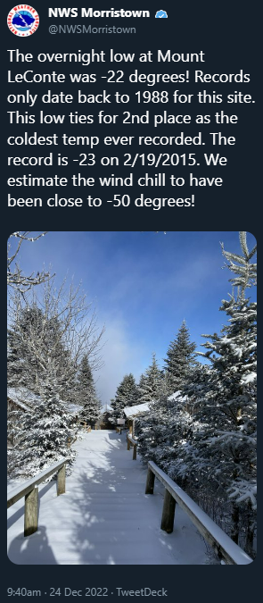
Figure 6 is a map of high and low temperatures across the country on Friday, December 23, 2022. At Knoxville, the high temperature for the day was 51 degrees, which occurred at midnight before the arrival of the cold front. The low temperature by midnight Friday night was 7 degrees. Colder temperatures were observed on Christmas Eve, shown in Figure 7. In some parts of the country, the low temperatures dropped well below -25 degrees!
 |
 |
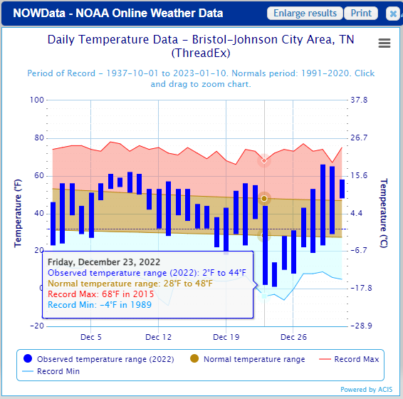 |
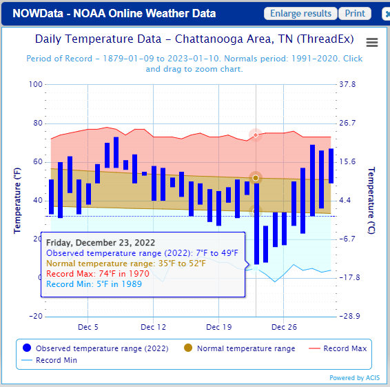
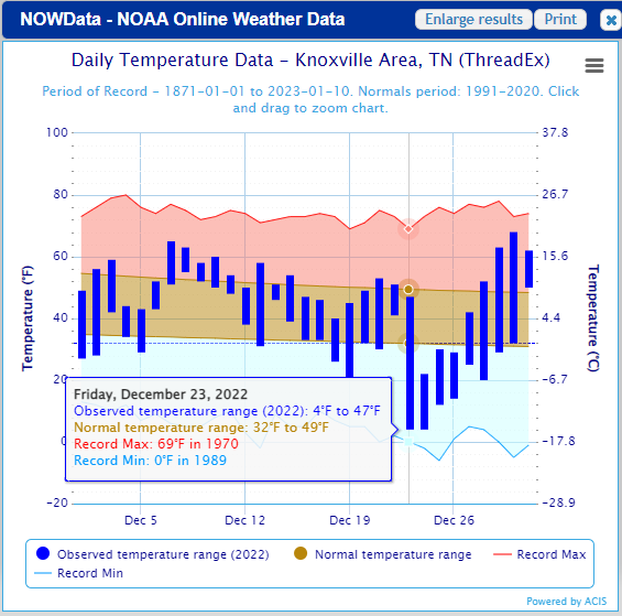
| Figure 9: Chattanooga Daily Record, Normal, and Observed Temperatures | Figure 10: Knoxville Daily Record, Normal, and Observed Temperatures | Figure 11: Tri-Cities Daily Record, Normal, and Observed Temperatures |
These plots of daily temperatures during December show how extreme the cold temperatures were compared to normal, and the huge temperature drop that occurred on Friday, December 23rd. The observed temperature range at all three sites on Friday was over 40 degrees, while a normal daily temperature range is about 17 to 20 degrees. Although record low temperatures were not set during this event, record low maximum temperatures were set on Saturday, December 24th. East Tennessee has experienced colder temperatures in the past, but it was the combination of extremely cold temperatures and high winds that made this weather event unique.
 |
Media use of NWS Web News Stories is encouraged! Please acknowledge the NWS as the source of any news information accessed from this site. |
|


 Local Radar
 Huntsville Radar
 Regional Satellite
 Graphical Forecast
 Weather Map