
Widespread life-threatening flash and urban flooding will continue to pose a significant threat to life and property in south-central Texas. Catastrophic fiver flooding, with rapid rises on small streams, arroyos, and typically dry washes, is expected. Monsoonal showers persist across the Great Basin and Southwest with greatest flash flooding in southern Arizona. Read More >
Overview
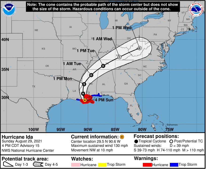
Hurricane Ida made landfall in southeast Louisiana on August 29 as a Category 4 hurricane. The remnants of Ida slowly moved north and eastward, reaching the Tennessee Valley on August 31 and crossing the southern Appalachians and moving into the Mid Atlantic and Northeast United States on September 1. Widespread rain accompanied the passage of Ida's remnants with parts of the Plateau and much of the Valley receiving heavy amounts that caused localized flooding. In addition, gusty winds occurred in the higher elevations of the Smokies with peak gusts of 46 mph at Cove Mountain, 45 mph at Clingman's Dome, and 41 mph at Camp Creek during the afternoon on August 31 which led to some tree damage.Flooding
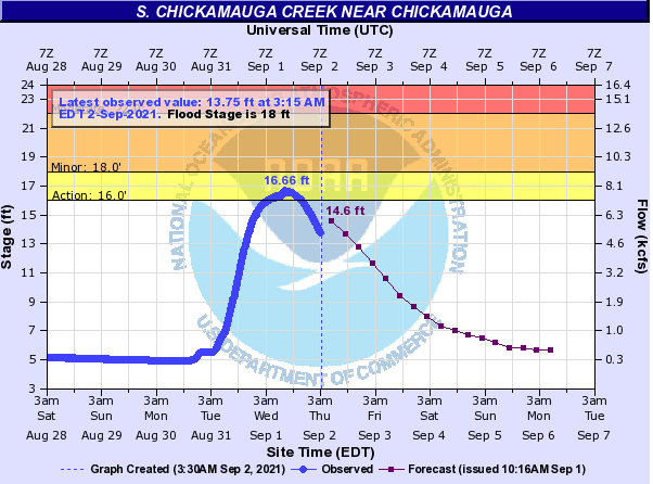
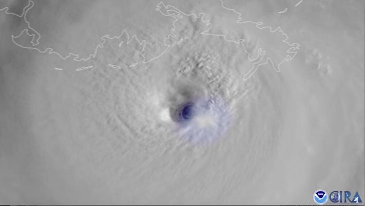
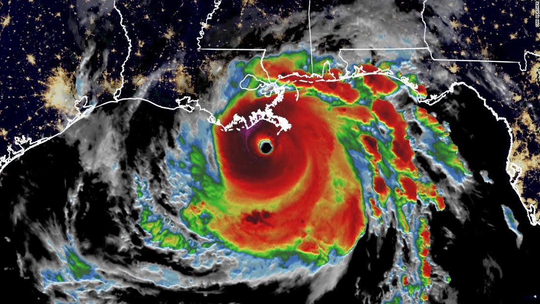
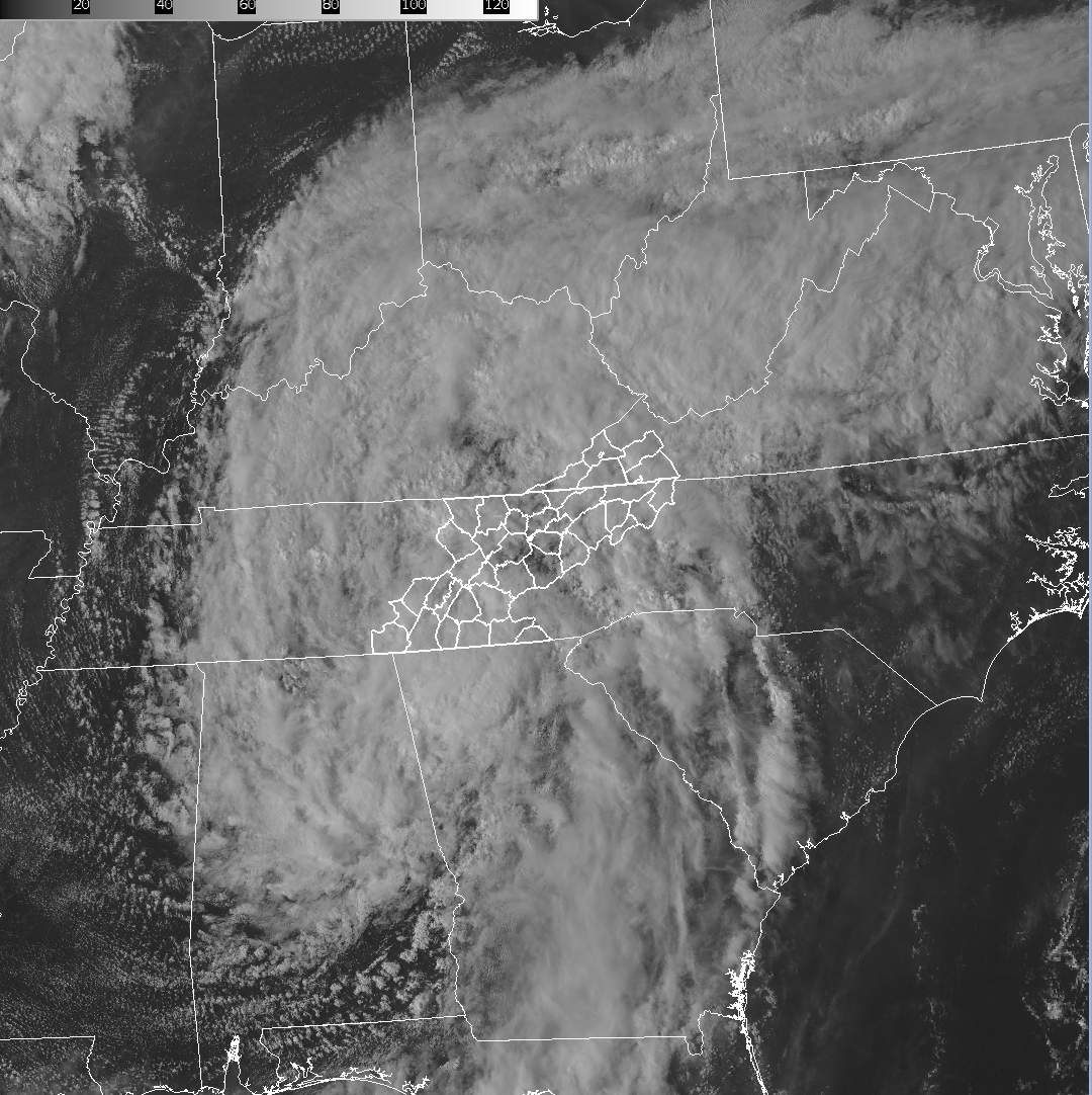
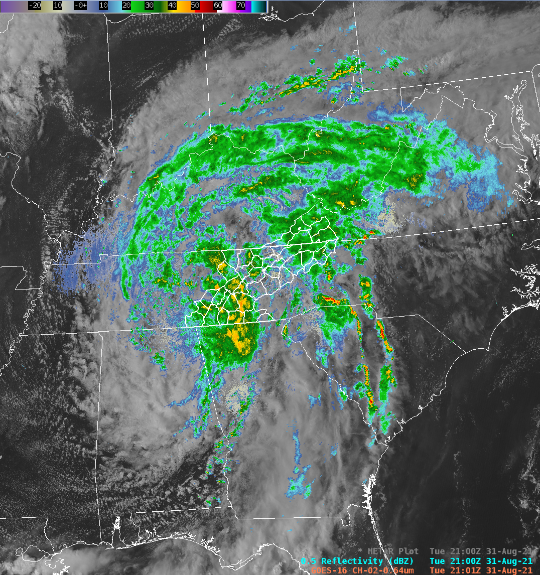
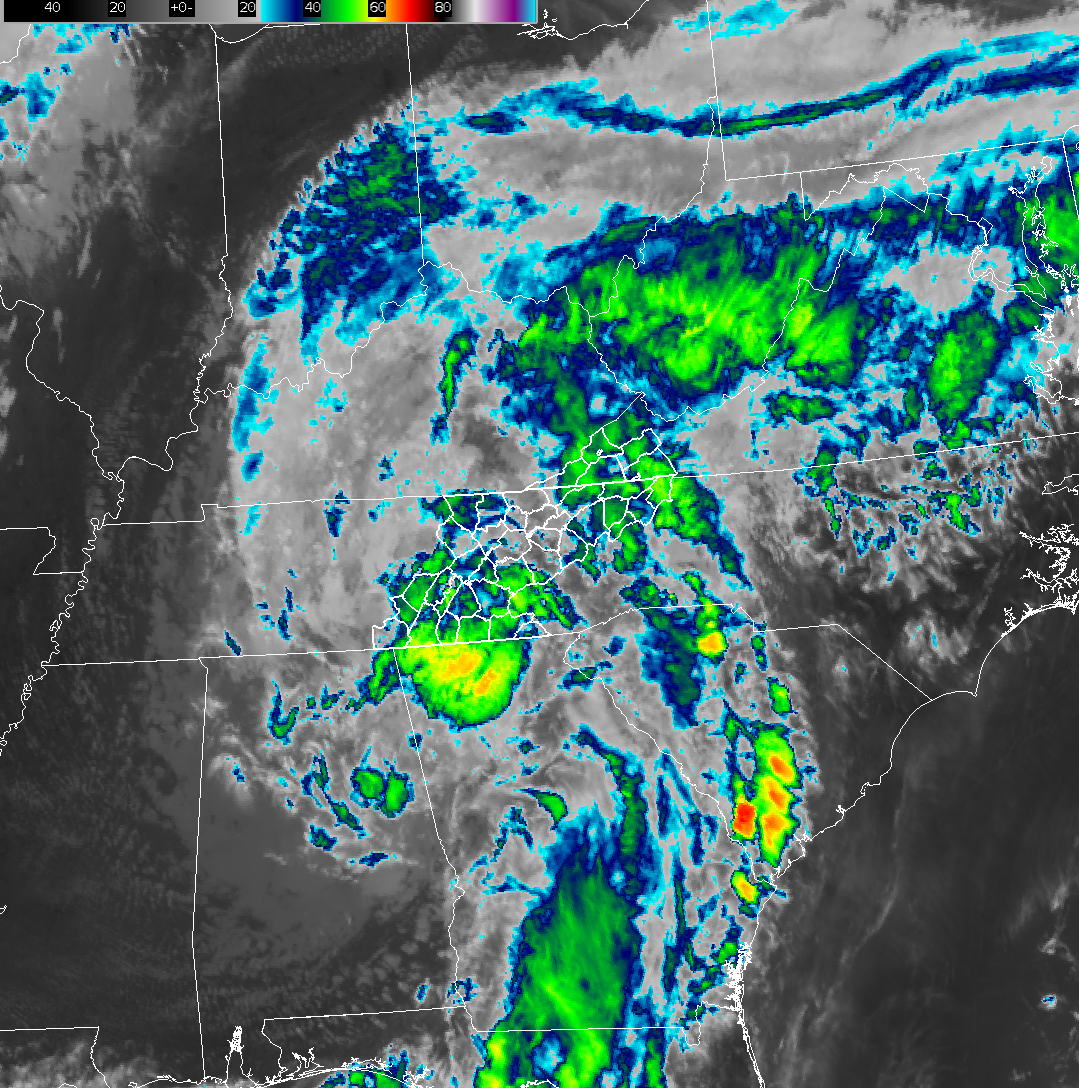
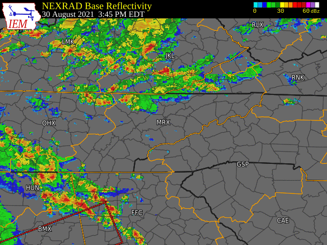
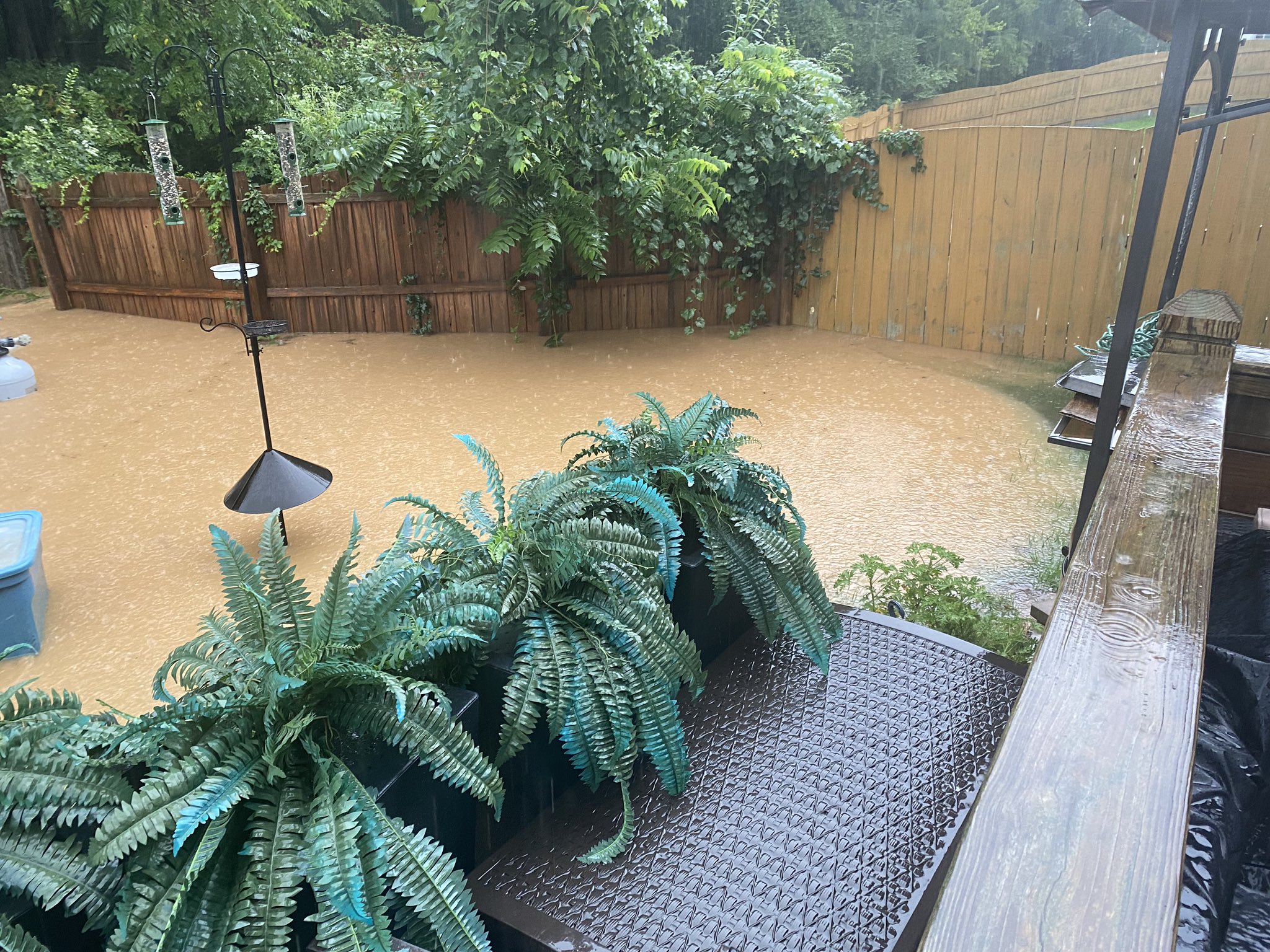
The outer bands of Ida first reached the area on Monday August 30 during the evening. An impressive band of showers and thunderstorms lifted northward from the southern Plateau and southern valley through the northern Plateau and northern valley producing a period of heavy rain and gusty winds. After a break, a more persistent wave of light to moderate rain slowly moved into the southern Valley and Plateau during the early morning hours of Tuesday August 31 followed by periods of light to moderate and occasionally heavy rain across the rest of the region during the afternoon and evening. Scattered showers then continued into Wednesday, September 1 in the northwesterly flow pattern as Ida's remnant circulation lifted into the Northeast United States. Storm total rainfall of 2 to 4 inches were common from the Plateau up much of the Valley, generally along and west of I-75 and I-81. Locally heavier amounts of 4 to 6 inches fell over parts of the central and northern valley. Significantly lower amounts fell farther east from southwest North Carolina along the mountains and through northeast Tennessee and southwest Virginia. The heavy rainfall resulted in localized flooding in urban areas around Knoxville, as well as in low-lying country roads near creeks and streams in rural areas. The South Chickamauga Creek near Chickamauga rose to near minor flood stage with a crest of 16.66 feet. Minor flood stage is 18 feet, so it was only 1.34 feet below minor flood stage. Additionally, the Tellico River near Tellico Plains rose above minor flood stage cresting at 9.91 feet, well above the minor flood stage of 9 feet. Satellite imagery shows Ida shortly before landfall on Sunday August 29, as well as inland as a depression over the Tennessee Valley on Tuesday August 31. A radar loop from 3:45 PM EDT on Monday August 30 through 5:00 AM EDT on Wednesday September 1 shows the periods of heaviest rain that moved through the region.
Hydrographs
 |
.PNG) |
| South Chickamauga Creek near Chickamauga | Tellico River near Tellico Plains |
Satellite and Radar Imagery
 |
 |
| Visible Satellite Imagery of Hurricane Ida just before Making Landfall on Aug 29th | Infrared (IR) Satellite Imagery of Hurricane Ida just before Making Landfall on Aug 29th |
 |
 |
 |
 |
| Visible Satellite Imagery of Ida's Remnants at 5 PM EDT on Sun, Aug 31st | Radar Imagery overlaid with Visible Satellite Imagery at 5 PM EDT on Sun, Aug 31st | IR Satellite Imagery at 5 PM EDT on Sun, Aug 31st | Radar Loop from 3:45 PM EDT 08/30 through 5:00 AM EDT 09/01 |
Photos & Video
 |
 |
 |
| Backyard Flooding at a Home in Farragut, TN (Courtesy, WATE-TV Viewer Photo) |
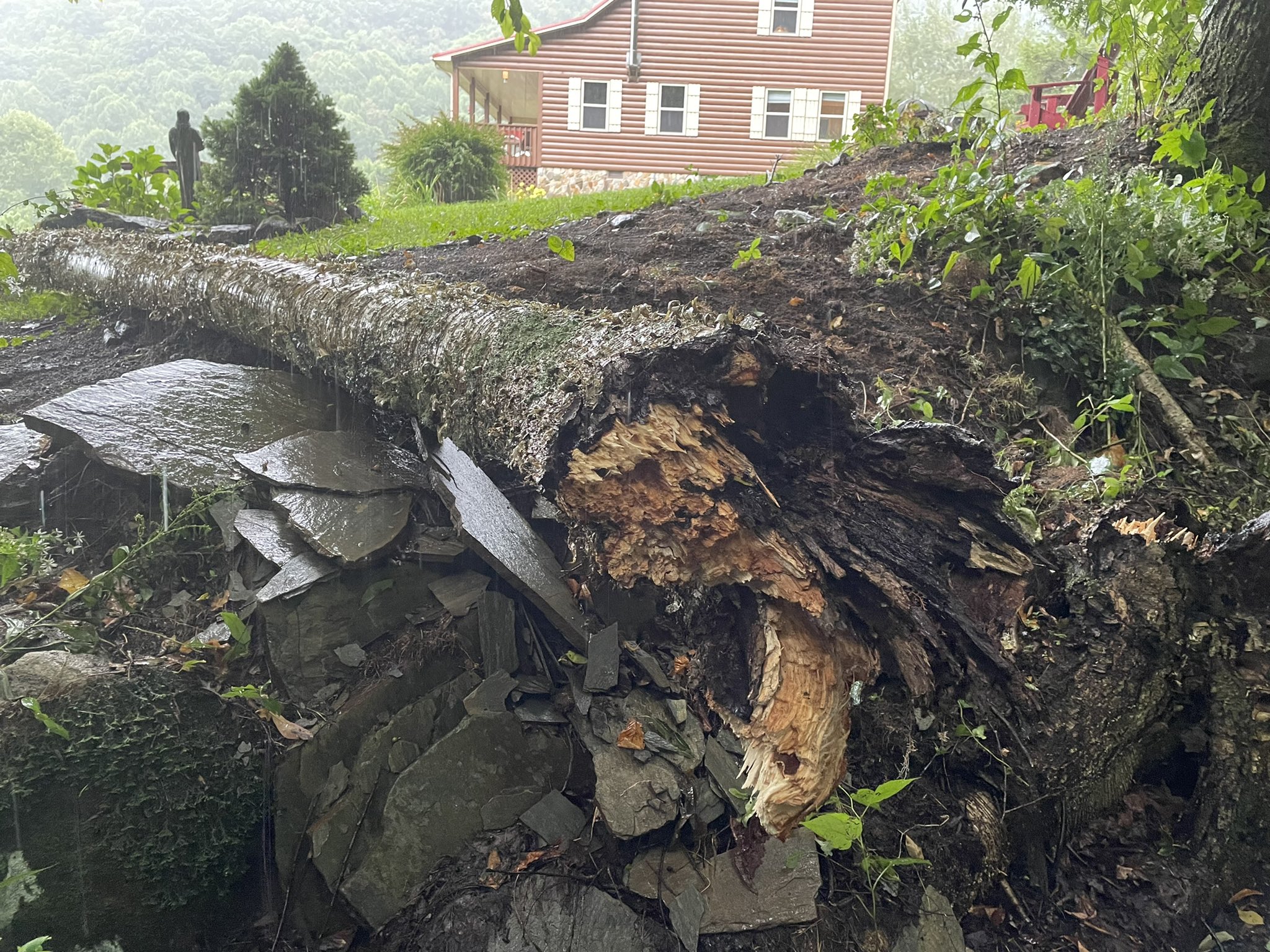
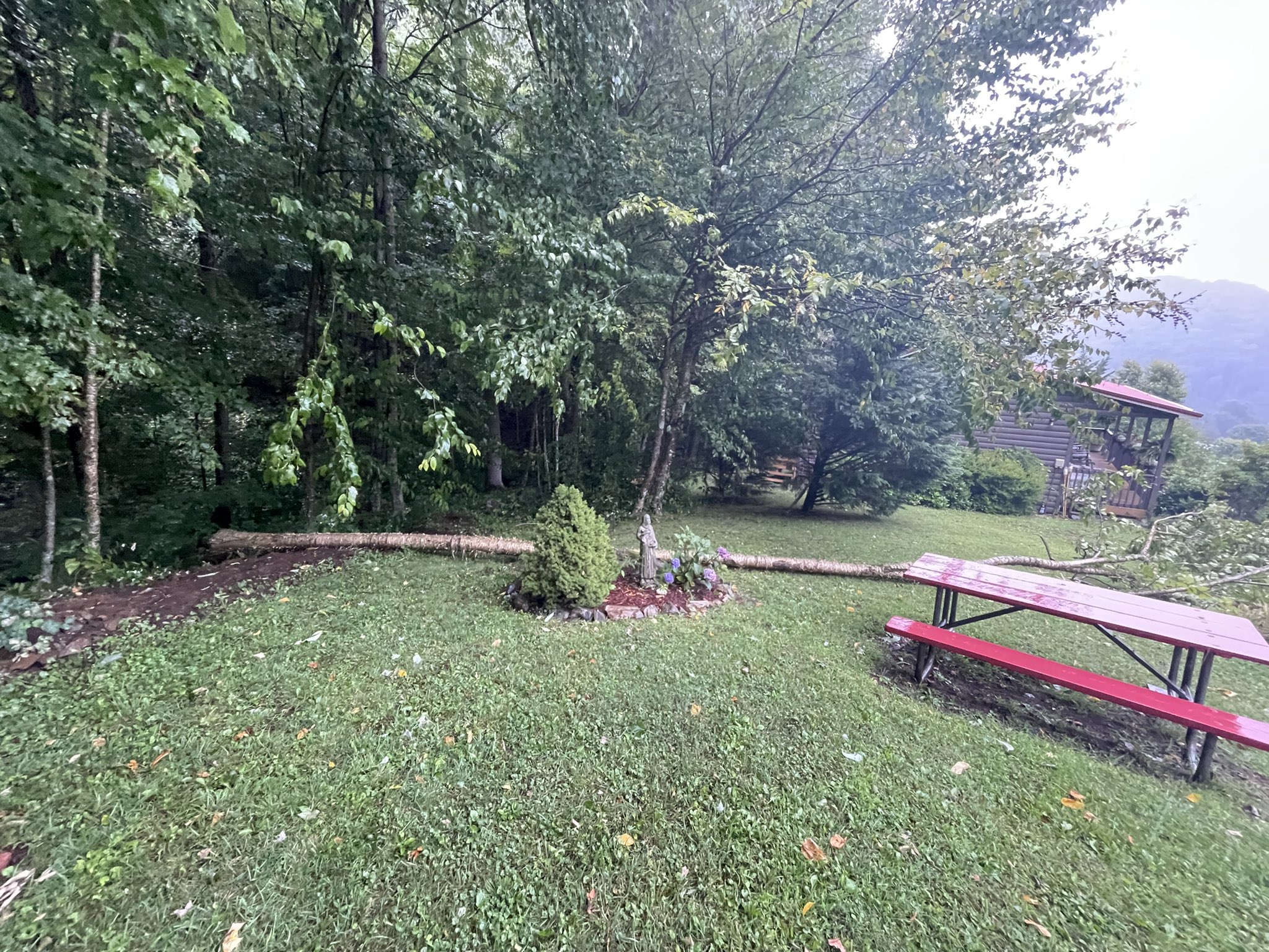
Downed Tree in Roan Mountain, TN (Courtesy, Tom Niziol) |
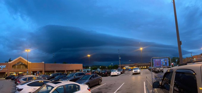
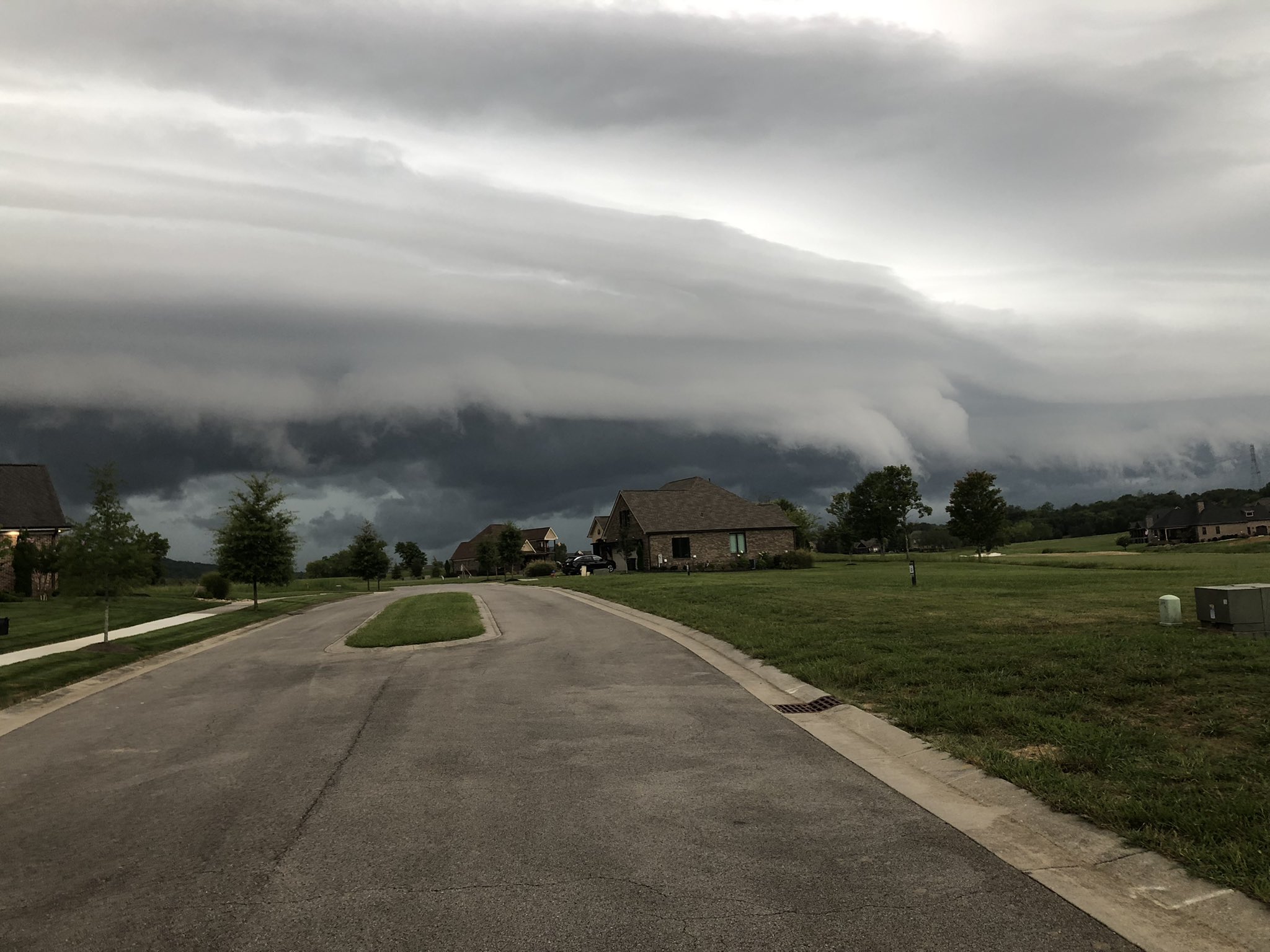
Shelf Cloud Viewed in Knoxville, TN (Courtesy, WATE-TV Viewer Photo) |
 |
 |
 |
| Downed Tree in Roan Mountain, TN (Courtesy, Tom Niziol) |
Shelf Cloud Viewed in Loudon, TN (Courtesy, Skip Evans) |
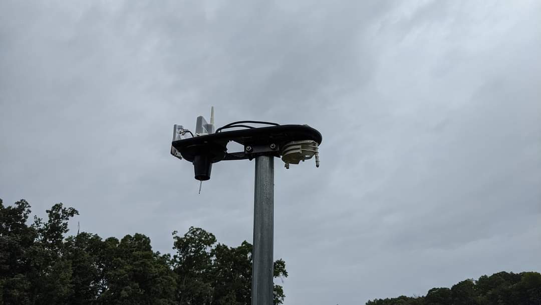
Lightning Damaged Davis Weather Station in Strawberry Plains, TN (Courtesy, Jeremy Buckles) |
Rain Reports
Below is an MRMS (Multi-Radar/Multi-Sensor System) estimate of rainfall totals from Ida's remnants.
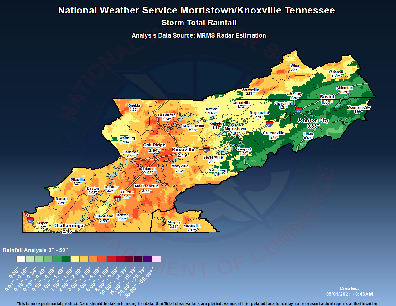
...PRELIMINARY STORM TOTAL PRECIPITATION REPORTS FOR HURRICANE IDA...

LOCATION                     AMOUNT    TIME/DATE       LAT/LON
BENTON 2.3 ESE               6.79 IN   0531 AM 09/01   35.17N/84.61W
KARNS                        6.74 IN   0807 AM 09/01   36.01N/84.07W
LENOIR CITY                  6.35 IN   0936 AM 09/01   35.84N/84.30W
KNOXVILLE                    6.02 IN   0807 AM 09/01   35.95N/84.14W
ETOWAH                       6.00 IN   0944 AM 09/01   35.33N/84.54W
3.4 N MARBLE                 5.97 IN   1020 PM 08/31   35.22N/83.92W
FARRAGUT 2.8 ENE             5.96 IN   0700 AM 09/01   35.89N/84.14W
KNOXVILLE                    5.91 IN   0938 AM 09/01   35.97N/84.04W
KNOXVILLE 10.6 WSW           5.89 IN   0640 AM 09/01   35.94N/84.13W
KARNS                        5.27 IN   1038 PM 08/31   36.01N/84.07W
NORRIS 0.6 NW                5.23 IN   0700 AM 09/01   36.20N/84.08W
OCOEE (3 SW RELIANCE)        5.19 IN   0905 AM 09/01   35.16N/84.59W
GREENBACK 2.1 ENE            5.18 IN   0700 AM 09/01   35.67N/84.14W
UNAKA                        5.10 IN   1200 AM 08/31   35.20N/84.15W
0.8 SE ETOWAH                5.06 IN   0800 AM 09/01   35.33N/84.52W
1.8 W NORRIS                 4.96 IN   0800 AM 09/01   36.22N/84.09W
OAK RIDGE 3.1 NNW            4.93 IN   0700 AM 09/01   36.00N/84.32W
LENOIR CITY                  4.91 IN   1037 PM 08/31   35.84N/84.30W
DAYTON                       4.90 IN   0800 AM 09/01   35.50N/85.02W
WFO MORRISTOWN               4.89 IN   0800 AM 09/01   36.17N/83.40W
NEWFOUND GAP                 4.85 IN   0800 AM 09/01   35.61N/83.43W
RAINBOW SPRINGS              4.82 IN   0935 AM 09/01   35.08N/83.59W
GRAYSVILLE 5.5 WNW           4.77 IN   0700 AM 09/01   35.47N/85.18W
LENOIR CITY LOOKOUT TWR      4.72 IN   0905 AM 09/01   35.84N/84.33W
1 NNE MADISONVILLE           4.70 IN   0700 AM 09/01   35.54N/84.35W
3 S LENOIR CITY              4.55 IN   0800 AM 09/01   35.75N/84.27W
1.5 E LENOIR CITY            4.46 IN   0800 AM 09/01   35.79N/84.25W
ATHENS                       4.44 IN   0800 AM 09/01   35.47N/84.59W
3.7 NW KARNS                 4.44 IN   0800 AM 09/01   36.02N/84.16W
GATLINBURG 5 SE              4.43 IN   0700 AM 09/01   35.66N/83.44W
LOUDON 5.1 ESE               4.38 IN   0700 AM 09/01   35.71N/84.27W
OAK RIDGE 8.1 ENE            4.35 IN   0700 AM 09/01   36.02N/84.17W
BEAVER CREEK                 4.33 IN   0930 AM 09/01   36.02N/84.05W
KNOXVILLE                    4.31 IN   1039 PM 08/31   35.95N/84.14W
HIAWASSE DAM                 4.31 IN   0800 AM 09/01   35.15N/84.18W
DAYTON                       4.28 IN   0900 PM 08/31   35.50N/85.02W
MURPHY                       4.28 IN   0936 AM 09/01   35.09N/84.05W
0.9 SE SPRING CITY           4.27 IN   0730 AM 09/01   35.68N/84.85W
5.4 S OAK RIDGE              4.26 IN   0800 AM 09/01   35.88N/84.30W
HAYESVILLE 5.2 E             4.26 IN   0800 AM 09/01   35.05N/83.73W
ANDREWS NC                   4.23 IN   0935 AM 09/01   35.18N/83.85W
OCOEE (3 SW RELIANCE)        4.19 IN   0905 PM 08/31   35.16N/84.59W
CHATTANOOGA                  4.19 IN   0930 AM 09/01   35.12N/85.37W
SIGNAL MOUNTAIN 2.2 NE       4.17 IN   0700 AM 09/01   35.15N/85.31W
1.3 E GREENBACK              4.17 IN   0800 AM 09/01   35.65N/84.15W
CHATTANOOGA                  4.17 IN   0935 AM 09/01   35.06N/85.35W
1 NE SIGNAL MOUNTAIN         4.15 IN   0700 AM 09/01   35.15N/85.32W
0.6 SE SWEETWATER            4.12 IN   0900 AM 09/01   35.59N/84.46W
CLEVELAND 5.2 SE             4.10 IN   0700 AM 09/01   35.12N/84.81W
1.9 N KINGSTON               4.09 IN   0800 AM 09/01   35.90N/84.52W
3 SW PETROS                  4.08 IN   0900 AM 09/01   36.06N/84.49W
1.8 NW TELLICO PLAINS        4.05 IN   0800 AM 09/01   35.38N/84.32W
MARYVILLE                    4.03 IN   0939 AM 09/01   35.70N/84.02W
3.5 W KARNS                  4.02 IN   0910 AM 09/01   35.97N/84.18W
1.1 NE MARBLE                4.01 IN   0800 AM 09/01   35.19N/83.92W
CHATTANOOGA                  4.01 IN   0930 AM 09/01   35.00N/85.13W
HARRIMAN 4.1 NNE             3.99 IN   0700 AM 09/01   35.99N/84.55W
TEN MILE                     3.99 IN   0937 AM 09/01   35.69N/84.70W
1.5 NW MCCAYSVILLE-COPPERHIL 3.97 IN   0800 AM 09/01   35.00N/84.39W
ROCKWOOD 11.3 S              3.96 IN   0800 AM 09/01   35.64N/84.62W
KNOXVILLE                    3.93 IN   1039 PM 08/31   35.97N/84.04W
PETROS                       3.93 IN   0800 AM 09/01   36.10N/84.45W
OAK RIDGE                    3.93 IN   0853 AM 09/01   36.02N/84.23W
0.7 W ONEIDA                 3.91 IN   0700 AM 09/01   36.50N/84.53W
OOLTEWAH                     3.91 IN   0931 AM 09/01   35.15N/85.05W
MURPHY                       3.89 IN   0800 AM 09/01   35.11N/84.01W
SWEETWATER                   3.84 IN   1030 PM 08/31   35.60N/84.47W
ONEIDA                       3.82 IN   0800 AM 09/01   36.50N/84.52W
DELANO                       3.82 IN   0906 AM 09/01   35.25N/84.58W
FRIENDSVILLE 3.6 NW          3.81 IN   0802 AM 09/01   35.80N/84.17W
KNOXVILLE 5.7 NNW            3.80 IN   0700 AM 09/01   36.05N/83.99W
5.7 N LOOKOUT MOUNTAIN       3.79 IN   0800 AM 09/01   35.06N/85.39W
ETOWAH                       3.78 IN   1039 PM 08/31   35.33N/84.54W
TOPTON                       3.68 IN   0930 AM 09/01   35.24N/83.71W
1.8 W NORRIS                 3.67 IN   0900 PM 08/31   36.22N/84.09W
LOOKOUT MOUNTAIN 1 SE        3.67 IN   0800 AM 09/01   35.01N/85.34W
0.8 SW CHARLESTON            3.66 IN   0800 AM 09/01   35.28N/84.77W
HIAWASSE DAM                 3.65 IN   0900 PM 08/31   35.15N/84.18W
CHATTANOOGA                  3.65 IN   1030 PM 08/31   35.12N/85.37W
ONEIDA                       3.64 IN   0808 AM 09/01   36.53N/84.52W
LOUDON                       3.63 IN   0931 AM 09/01   35.66N/84.29W
HAYESVILLE                   3.63 IN   0935 AM 09/01   35.09N/83.74W
MADISONVILLE                 3.63 IN   0937 AM 09/01   35.48N/84.40W
MURPHY 15.7 WSW              3.61 IN   0610 AM 09/01   35.00N/84.28W
OCOEE 3.3 ESE                3.61 IN   0700 AM 09/01   35.10N/84.67W
4 SSE GREENBACK              3.56 IN   0615 AM 09/01   35.60N/84.14W
0.6 SE SWEETWATER            3.55 IN   1000 PM 08/31   35.59N/84.46W
INDIAN GRAVE GAP (2 N CADES  3.55 IN   0855 AM 09/01   35.62N/83.81W
1.6 SW TASSO                 3.53 IN   0800 AM 09/01   35.18N/84.82W
BRASSTOWN                    3.53 IN   0932 AM 09/01   35.02N/83.97W
0.8 SE ETOWAH                3.50 IN   0900 PM 08/31   35.33N/84.52W
CULBERSON                    3.49 IN   0905 PM 08/31   35.04N/84.23W
1.3 NE TASSO                 3.48 IN   1200 AM 09/01   35.22N/84.80W
FARRAGUT 2.3 NE              3.48 IN   0700 AM 09/01   35.90N/84.15W
1.9 SW PEAKLAND              3.47 IN   0800 AM 09/01   35.61N/84.79W
HAYESVILLE                   3.46 IN   0939 AM 09/01   35.05N/83.73W
3.8 NW HALLS                 3.44 IN   0845 AM 09/01   36.11N/83.99W
TEN MILE 2.2 NW              3.43 IN   0700 AM 09/01   35.68N/84.71W
0.6 W MURPHY                 3.41 IN   0800 AM 09/01   35.09N/84.04W
HARRISON                     3.40 IN   0938 AM 09/01   35.20N/85.06W
2.3 W EAGLE FURNACE          3.39 IN   0800 AM 09/01   35.77N/84.78W
2 E OLD CUMBERLAND           3.39 IN   0800 AM 09/01   35.55N/85.33W
MARYVILLE 4.1 SSW            3.39 IN   0800 AM 09/01   35.70N/84.01W
HARRISON                     3.38 IN   0930 AM 09/01   35.29N/85.05W
5.7 N LOOKOUT MOUNTAIN       3.37 IN   0900 PM 08/31   35.06N/85.39W
HAYESVILLE                   3.37 IN   0937 AM 09/01   35.02N/83.69W
SEVIERVILLE                  3.36 IN   0931 AM 09/01   35.93N/83.67W
FRIENDSVILLE 2.3 ESE         3.35 IN   0600 AM 09/01   35.74N/84.09W
6.6 S BULLET CREEK           3.35 IN   0800 AM 09/01   35.18N/84.44W
MURPHY                       3.34 IN   1036 PM 08/31   35.09N/84.05W
KINGSTON                     3.34 IN   0930 AM 09/01   35.86N/84.49W
PRENTICE COOPER SF           3.32 IN   0906 AM 09/01   35.13N/85.43W
OAK RIDGE                    3.30 IN   0931 AM 09/01   36.02N/84.21W
SODDY DAISY                  3.29 IN   0940 AM 09/01   35.34N/85.17W
1.9 N KINGSTON               3.28 IN   0900 PM 08/31   35.90N/84.52W
ATHENS                       3.26 IN   0900 PM 08/31   35.47N/84.59W
3 WSW ALCOA                  3.26 IN   0944 AM 09/01   35.77N/84.03W
ROCKWOOD                     3.25 IN   0933 AM 09/01   35.87N/84.66W
4 NNE OAK RIDGE              3.25 IN   0945 AM 09/01   36.02N/84.26W
PARKSVILLE                   3.22 IN   0800 AM 09/01   35.09N/84.65W
1.5 NW MCCAYSVILLE-COPPERHIL 3.21 IN   0900 PM 08/31   35.00N/84.39W
MURPHY 12.1 WSW              3.21 IN   0815 AM 09/01   35.00N/84.21W
LENOIR CITY LOOKOUT TWR      3.20 IN   0905 PM 08/31   35.84N/84.33W
1.3 E GREENBACK              3.19 IN   0900 PM 08/31   35.65N/84.15W
ANDREWS NC                   3.19 IN   1015 PM 08/31   35.18N/83.85W
SIGNAL MOUNTAIN              3.18 IN   1038 PM 08/31   35.18N/85.32W
TOWNSEND 5 S                 3.18 IN   0700 AM 09/01   35.60N/83.78W
CHATTANOOGA                  3.16 IN   1036 PM 08/31   35.06N/85.35W
RAINBOW SPRINGS              3.14 IN   1035 PM 08/31   35.08N/83.59W
APPALACHIA                   3.12 IN   0800 AM 09/01   36.90N/82.79W
DECATUR                      3.12 IN   0800 AM 09/01   35.52N/84.80W
OOLTEWAH                     3.11 IN   1030 PM 08/31   35.15N/85.05W
2 W OOLTEWAH                 3.10 IN   0940 AM 09/01   35.06N/85.14W
1.5 E LENOIR CITY            3.09 IN   0900 PM 08/31   35.79N/84.25W
CLINTON                      3.09 IN   0932 AM 09/01   36.11N/84.21W
OOLTEWAH                     3.08 IN   0937 AM 09/01   35.12N/85.10W
EUCHEE                       3.08 IN   0940 AM 09/01   35.68N/84.71W
BEAVER CREEK                 3.07 IN   1030 PM 08/31   36.02N/84.05W
KODAK                        3.07 IN   0931 AM 09/01   35.97N/83.66W
CHATTANOOGA                  3.06 IN   0932 AM 09/01   35.04N/85.25W
2 NE OOLTEWAH                3.06 IN   0945 AM 09/01   35.08N/85.06W
2 NNW SIGNAL MOUNTAIN        3.04 IN   0945 AM 09/01   35.16N/85.36W
3 ESE LONE OAK               3.03 IN   0940 AM 09/01   35.18N/85.31W
TEN MILE                     3.02 IN   1038 PM 08/31   35.69N/84.70W
CHATUGE DAM                  3.02 IN   0800 AM 09/01   35.02N/83.79W
EAST RIDGE 1.0 NW            3.02 IN   0800 AM 09/01   35.01N/85.24W
CHATTANOOGA 5.1 ENE          3.01 IN   0700 AM 09/01   35.10N/85.18W
CHATTANOOGA AIRPORT          2.98 IN   0859 AM 09/01   35.03N/85.20W
6.6 S BULLET CREEK           2.93 IN   0900 PM 08/31   35.18N/84.44W
LOUDON                       2.92 IN   1030 PM 08/31   35.66N/84.29W
DELANO                       2.91 IN   0906 PM 08/31   35.25N/84.58W
PETROS                       2.90 IN   0600 AM 09/01   36.09N/84.44W
FLATWOODS                    2.89 IN   0911 AM 09/01   36.89N/82.46W
PRENTICE COOPER SF           2.88 IN   0906 PM 08/31   35.13N/85.43W
3.7 NW KARNS                 2.87 IN   0900 PM 08/31   36.02N/84.16W
NEWFOUND GAP                 2.86 IN   0900 PM 08/31   35.61N/83.43W
3 N NOTTELY DAM              2.83 IN   0710 AM 09/01   35.01N/84.09W
SIGNAL MOUNTAIN              2.83 IN   0938 AM 09/01   35.18N/85.32W
DUNLAP 2.9 W                 2.81 IN   0800 AM 09/01   35.37N/85.44W
0.9 S SEVIERVILLE            2.80 IN   0800 AM 09/01   35.88N/83.58W
BISO-NP                      2.80 IN   0853 AM 09/01   36.48N/84.65W
3.4 S NORTON                 2.80 IN   0900 AM 09/01   36.88N/82.62W
PIKEVILLE                    2.78 IN   0800 AM 09/01   35.61N/85.19W
3.5 W KARNS                  2.76 IN   1010 PM 08/31   35.97N/84.18W
PARKSVILLE                   2.73 IN   0900 PM 08/31   35.09N/84.65W
0.8 SW CHARLESTON            2.73 IN   0900 PM 08/31   35.28N/84.77W
0.7 SE DUNLAP                2.73 IN   0800 AM 09/01   35.36N/85.38W
SWEET HOME                   2.73 IN   0936 AM 09/01   35.78N/84.24W
1.6 SW TASSO                 2.72 IN   0900 PM 08/31   35.18N/84.82W
HARRISON                     2.72 IN   1031 PM 08/31   35.29N/85.05W
0.6 W MURPHY                 2.71 IN   0900 PM 08/31   35.09N/84.04W
1.8 NW TELLICO PLAINS        2.70 IN   0800 PM 08/31   35.38N/84.32W
1.1 NE MARBLE                2.70 IN   0900 PM 08/31   35.19N/83.92W
CHUCK SWAN ST FOREST         2.70 IN   0905 AM 09/01   36.37N/83.90W
EUCHEE                       2.68 IN   1036 PM 08/31   35.68N/84.71W
CHATTANOOGA                  2.66 IN   1030 PM 08/31   35.00N/85.13W
DUNLAP 2.3 SSE               2.66 IN   0800 AM 09/01   35.34N/85.37W
OOLTEWAH                     2.64 IN   1038 PM 08/31   35.12N/85.10W
2.8 NE CHATTANOOGA           2.63 IN   0800 AM 09/01   35.10N/85.23W
2.7 NW GEORGETOWN            2.63 IN   0800 AM 09/01   35.32N/84.97W
2 S CHATTANOOGA              2.62 IN   0945 AM 09/01   35.03N/85.26W
5.4 S OAK RIDGE              2.61 IN   0900 PM 08/31   35.88N/84.30W
WATERVILLE                   2.61 IN   0700 AM 09/01   35.11N/84.87W
OUTSIDE CITY LIMITS          2.60 IN   0813 AM 09/01   35.57N/84.79W
3 ESE LONE OAK               2.57 IN   1035 PM 08/31   35.18N/85.31W
CHATTANOOGA                  2.56 IN   1031 PM 08/31   35.04N/85.25W
2 W OOLTEWAH                 2.53 IN   1035 PM 08/31   35.06N/85.14W
1 E HARRISON                 2.53 IN   0700 AM 09/01   35.12N/85.12W
1.9 SW PEAKLAND              2.47 IN   0900 PM 08/31   35.61N/84.79W
CHATTANOOGA                  2.45 IN   0938 AM 09/01   35.10N/85.29W
KINGSTON                     2.43 IN   1030 PM 08/31   35.86N/84.49W
1.6 E CADES COVE             2.43 IN   0900 AM 09/01   35.60N/83.78W
2.3 W EAGLE FURNACE          2.42 IN   0800 PM 08/31   35.77N/84.78W
ROCKWOOD                     2.42 IN   1031 PM 08/31   35.87N/84.66W
OOLTEWAH 6.7 NNE             2.41 IN   0500 AM 09/01   35.15N/85.05W
2.7 NE WISE                  2.40 IN   0900 AM 09/01   37.00N/82.54W
2.8 NE CHATTANOOGA           2.39 IN   0900 PM 08/31   35.10N/85.23W
2.2 NW MIDDLE VALLEY         2.39 IN   1000 PM 08/31   35.21N/85.22W
0.6 S DUFFIELD               2.38 IN   0800 AM 09/01   36.71N/82.80W
KNOXVILLE MCGHEE TYSON       2.38 IN   0939 AM 09/01   35.82N/83.98W
ANDERSONVILLE                2.38 IN   0940 AM 09/01   36.19N/83.93W
KNOXVILLE (SHARPS RIDGE)     2.36 IN   0931 AM 09/01   36.01N/83.93W
BRASSTOWN                    2.34 IN   1031 PM 08/31   35.02N/83.97W
NEWCOMB                      2.34 IN   0800 AM 09/01   36.54N/84.17W
0.7 W SPEEDWELL              2.34 IN   0800 AM 09/01   36.46N/83.88W
OAK RIDGE                    2.32 IN   1031 PM 08/31   36.02N/84.21W
TOPTON                       2.32 IN   1040 PM 08/31   35.24N/83.71W
TAMPA                        2.32 IN   0658 AM 09/01   35.95N/84.01W
1.1 SW PENNINGTON GAP        2.32 IN   0800 AM 09/01   36.75N/83.04W
PIGEON FORGE                 2.32 IN   0931 AM 09/01   35.74N/83.62W
4 NNE OAK RIDGE              2.30 IN   1040 PM 08/31   36.02N/84.26W
OAK RIDGE                    2.29 IN   1026 PM 08/31   36.02N/84.23W
MARYVILLE 5.8 ESE            2.27 IN   0700 AM 09/01   35.73N/83.87W
JONESVILLE                   2.26 IN   0939 AM 09/01   36.70N/83.06W
MARYVILLE                    2.24 IN   1036 PM 08/31   35.70N/84.02W
MARYVILLE                    2.23 IN   0806 AM 09/01   35.74N/83.95W
2.2 NW MIDDLE VALLEY         2.20 IN   0900 AM 09/01   35.21N/85.22W
2.1 E WILDWOOD               2.19 IN   0800 AM 09/01   35.81N/83.84W
PETROS                       2.18 IN   0900 PM 08/31   36.10N/84.45W
KNOXVILLE                    2.18 IN   0934 AM 09/01   35.91N/83.88W
HAYESVILLE                   2.17 IN   1036 PM 08/31   35.09N/83.74W
0.9 S SEVIERVILLE            2.16 IN   0900 PM 08/31   35.88N/83.58W
3.8 NW HALLS                 2.15 IN   0945 PM 08/31   36.11N/83.99W
JONESVILLE 3.1 WSW           2.15 IN   0700 AM 09/01   36.67N/83.17W
CLEVELAND 4.1 NNE            2.15 IN   0730 AM 09/01   35.23N/84.84W
WASHBURN                     2.15 IN   0930 AM 09/01   36.29N/83.62W
1.0 SW COEBURN               2.13 IN   0800 AM 09/01   36.93N/82.48W
0.7 SE DUNLAP                2.12 IN   0800 PM 08/31   35.36N/85.38W
2.2 SE KNOXVILLE             2.12 IN   0800 AM 09/01   35.95N/83.93W
1 SSE PIKEVILLE              2.12 IN   0945 AM 09/01   35.59N/85.19W
3 SSW RED BANK               2.11 IN   0945 AM 09/01   35.07N/85.32W
2.7 NW GEORGETOWN            2.10 IN   0900 PM 08/31   35.32N/84.97W
HARRISON                     2.10 IN   1039 PM 08/31   35.20N/85.06W
WHITWELL                     2.09 IN   0935 AM 09/01   35.30N/85.43W
CLINTON                      2.07 IN   1031 PM 08/31   36.11N/84.21W
CHATTANOOGA                  2.06 IN   1038 PM 08/31   35.10N/85.29W
MARYVILLE                    2.04 IN   0806 AM 09/01   35.76N/83.95W
1.2 NW WARTBURG              2.03 IN   0800 AM 09/01   36.11N/84.60W
CORRYTON                     2.03 IN   0931 AM 09/01   36.09N/83.83W
CHATUGE DAM                  2.02 IN   0900 PM 08/31   35.02N/83.79W
JASPER 1.7 N                 2.02 IN   0700 AM 09/01   35.08N/85.63W
Environment
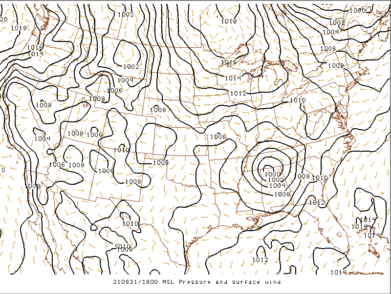
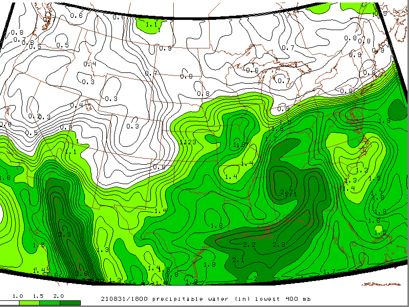
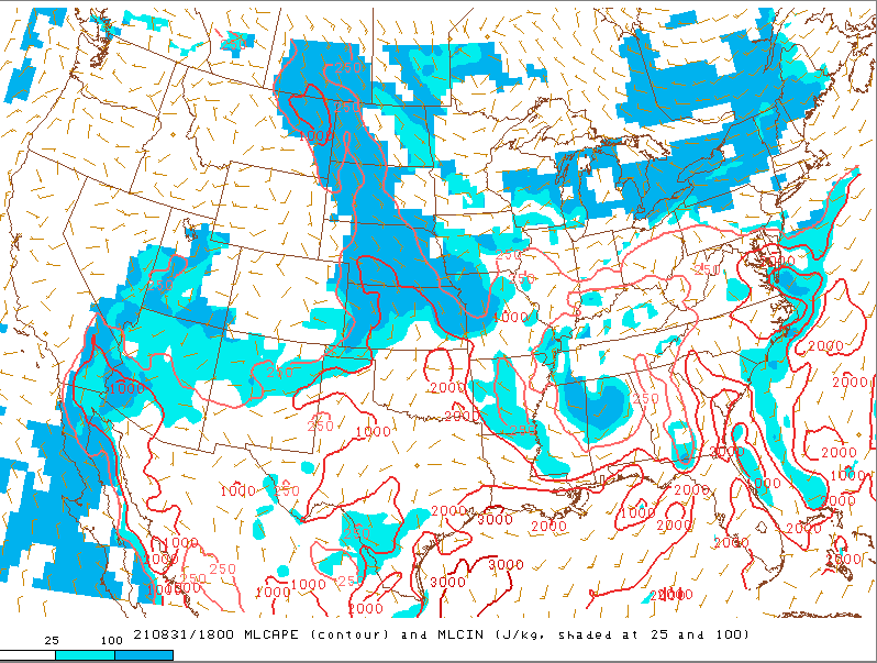
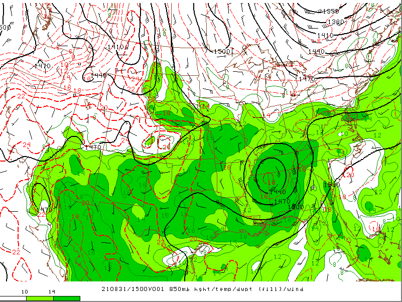
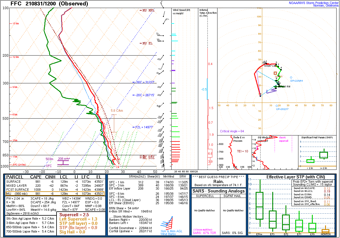
After Hurricane Ida made landfall Sunday afternoon August 29, it moved north and east and weakened to a tropical depression by the time it reached the Tennessee Valley early Tuesday morning on August 31. By early afternoon, Ida was centered along the Tennessee/Alabama border with a minimum central pressure of around 1000 mb. Deep south to southeasterly flow on the east side of the circulation advected copious amounts of moisture from the Gulf northward with strong moisture and theta e transport noted at 850 mb. This led to precipitable water values rising to over 2 inches and also boosted 850 mb dew points to 10-14 °C, setting up a warm, moist environment to support warm rain processes. The 12Z (8AM EDT) observed sounding from Atlanta, Georgia showed this environment well with a very moist profile, freezing levels near 15,000 feet, and LCL heights around 867 m leading to a deep warm cloud layer. The precipitable water value on this sounding was 2.04 inches. The south to southeasterly flow advected this airmass northward through the southern Appalachians through the afternoon. Another observed sounding taken at 18Z (2PM EDT) at the NOAA ATDD research laboratory in Oak Ridge, Tennessee showed that this airmass had advected in with a very saturated profile, freezing levels to nearly 16,000 feet, and LCL heights around 675 m leading to a very deep warm cloud layer. The precipitable water value on this sounding was an impressive 2.18 inches. This all supported highly efficient rainfall rates. Additionally, afternoon MLCAPE built to around 250 J/Kg with around 1000 J/Kg of surface based CAPE, and this caused some embedded convection to enhance rainfall rates in localized areas. Since low-level shear was strong at about 30-40 kts over the southern Appalachians Tuesday afternoon as the remnant circulation lifted northeastward, some of the embedded convection brought strong winds down to the ground leading to pockets of down trees and power lines in the southern and central valley. Outside of the convection, the gusty winds that occurred in the peaks and foothills of the southern Appalachians were the result of a 40 kt 850 mb jet oriented from the southeast which supports mountain wave induced downsloping on the downwind side of the mountain peaks. This also led to some down trees in the mountain peaks and foothills.
 |
 |
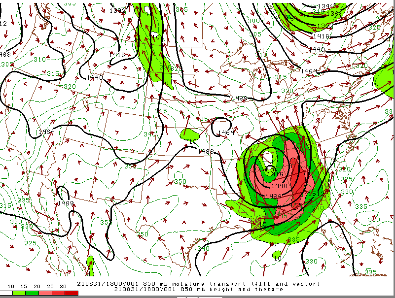 |
| Figure 1: Three Day Forecast Cone from NHC | Figure 2: Mean Sea Level Pressure (MSLP) | Figure 3: 850 mb Moisture Transport |
 |
 |
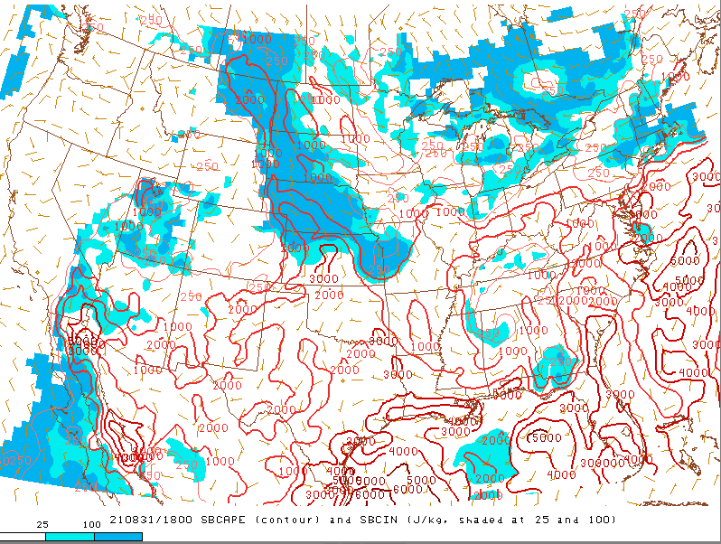 |
| Figure 4: Precipitable Water | Figure 5: MLCAPE | Figure 6: SBCAPE |
 |
 |
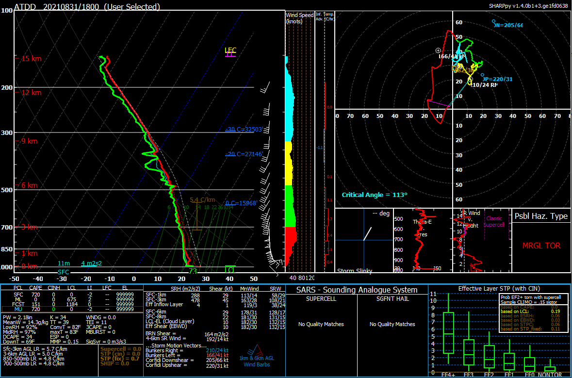 |
| Figure 7: 850 mb Heights, Temps, Dew Points, and Winds | Figure 8: 12Z Aug 31 Atlanta, GA Observed Sounding | Figure 9: 18Z Aug 31 Oak Ridge, TN Observed Sounding |
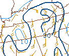 |
| Figure 10: Low-Level (0-1 Km) Shear |
 |
Media use of NWS Web News Stories is encouraged! Please acknowledge the NWS as the source of any news information accessed from this site. |
|


 Local Radar
 Huntsville Radar
 Regional Satellite
 Graphical Forecast
 Weather Map