
Flash flooding threatens areas from the Tennessee Valley to the Carolinas as storms repeat along a stalled front. Monsoonal storms may trigger flooding in the Southwest. Dangerous heat expands across the Desert Southwest, Plains, mid-Mississippi Valley and Southern Tier. Critical fire weather for interior Pacific Northwest. Cooler, drier air brings brief relief to the Great Lakes and Northeast. Read More >
Overview
During the afternoon and evening of May 16th, a system tracked near our forecast area, producing large-scale lift and a convective environment supportive of severe convection across much of Southern Appalachia and places nearby. All modes of severe weather occurred in our forecast area, including multiple EF-1 tornadoes in southwest Virginia. A total of 31 Local Storm Reports (LSRs) were received for the day, including 5 reports of 1" hail, 24 reports of straight line wind damage, and 2 confirmed tornadoes. There were no injuries or fatalities reported in the forecast area, but there were 2 injuries and 1 fatality that occurred from this event as a whole. At the time of this page being published, the confirmed tornadoes are still preliminary and are subject to change as additional information is gathered.
Tornadoes:
|
Tornado - Near Stickleyville, VA
Track Map  
Downloadable KMZ File |
||||||||||||||||
|
Tornado - Duffield, VA
Track Map 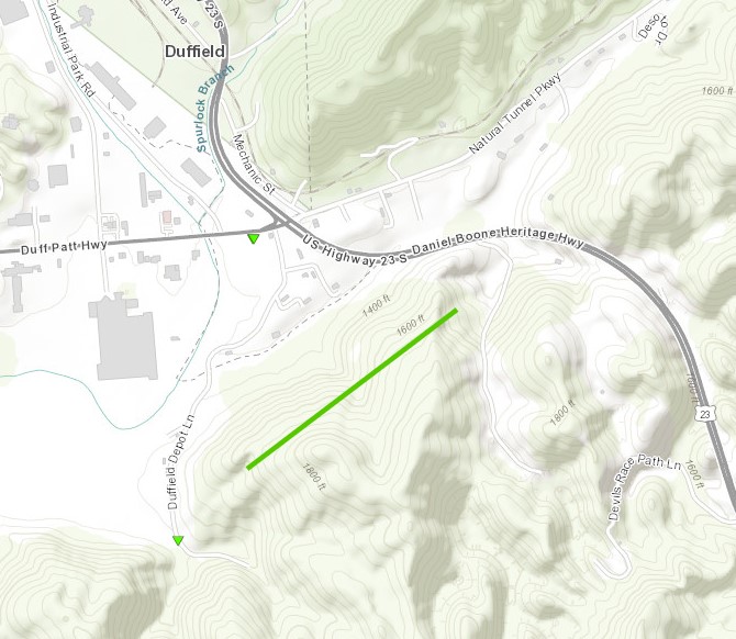
Downloadable KMZ File |
|||||||||||||||||
|
Tornado - 3 WSW Pennington Gap, VA
Track Map 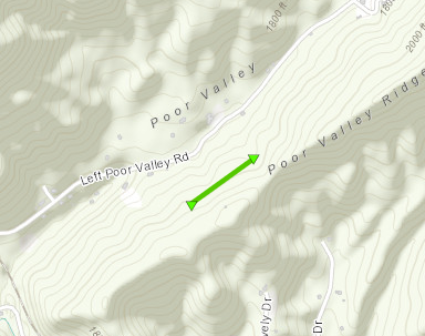
Downloadable KMZ File |
||||||||||||||||
The Enhanced Fujita (EF) Scale classifies tornadoes into the following categories:
| EF0 Weak 65-85 mph |
EF1 Moderate 86-110 mph |
EF2 Significant 111-135 mph |
EF3 Severe 136-165 mph |
EF4 Extreme 166-200 mph |
EF5 Catastrophic 200+ mph |
 |
|||||
Photos
 |
 |
 |
 |
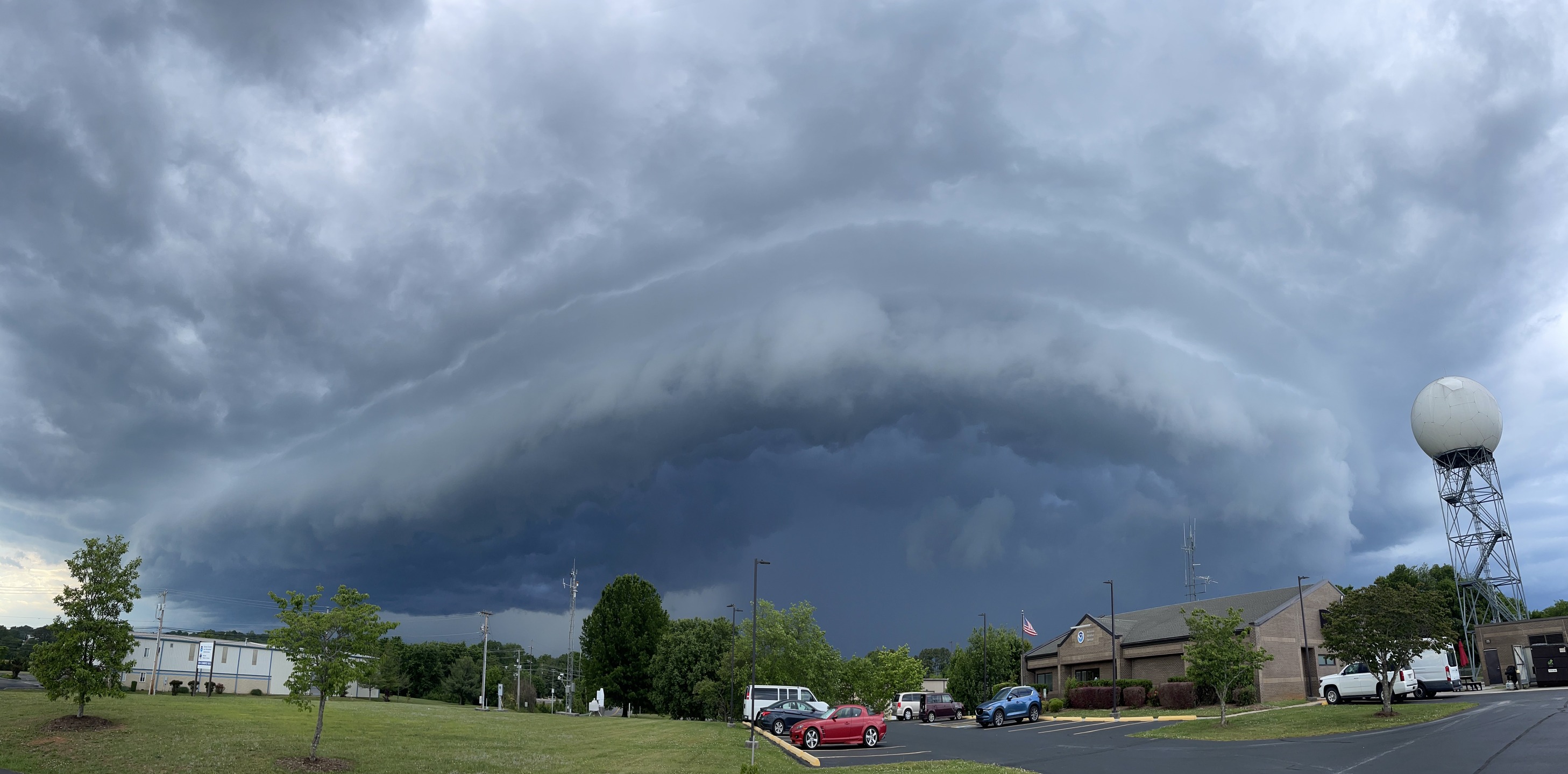
| Panoramic View of Shelf Cloud from the Morristown NWS Office (Courtesy: NWS Employee) |
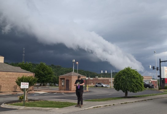
Shelf Cloud Viewed from Downtown Sevierville
(Courtesy: Jennifer Reimschuessel)
|
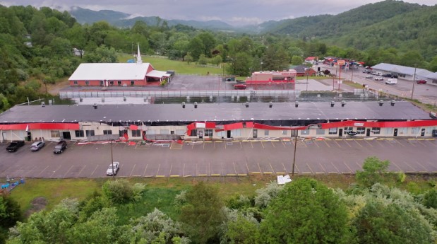
Damage to Pennington Gap Plaza, Pennington Gap, VA (Courtesy: WJHL-TV) |
Tree Damage in Pennington Gap, VA (Courtesy: Kim Carter) |
 |
 |
| Tree Down on Route 58 in Hilltons, VA (Courtesy: Pam Murray) |
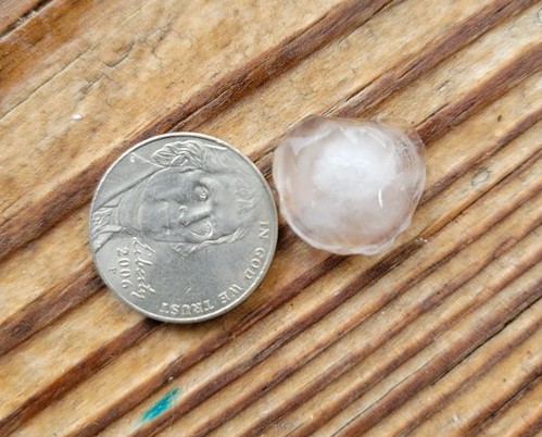
Quarter-Sized Hail in Boyd's Creek, TN (Courtesy: WATE-TV) |
Radar
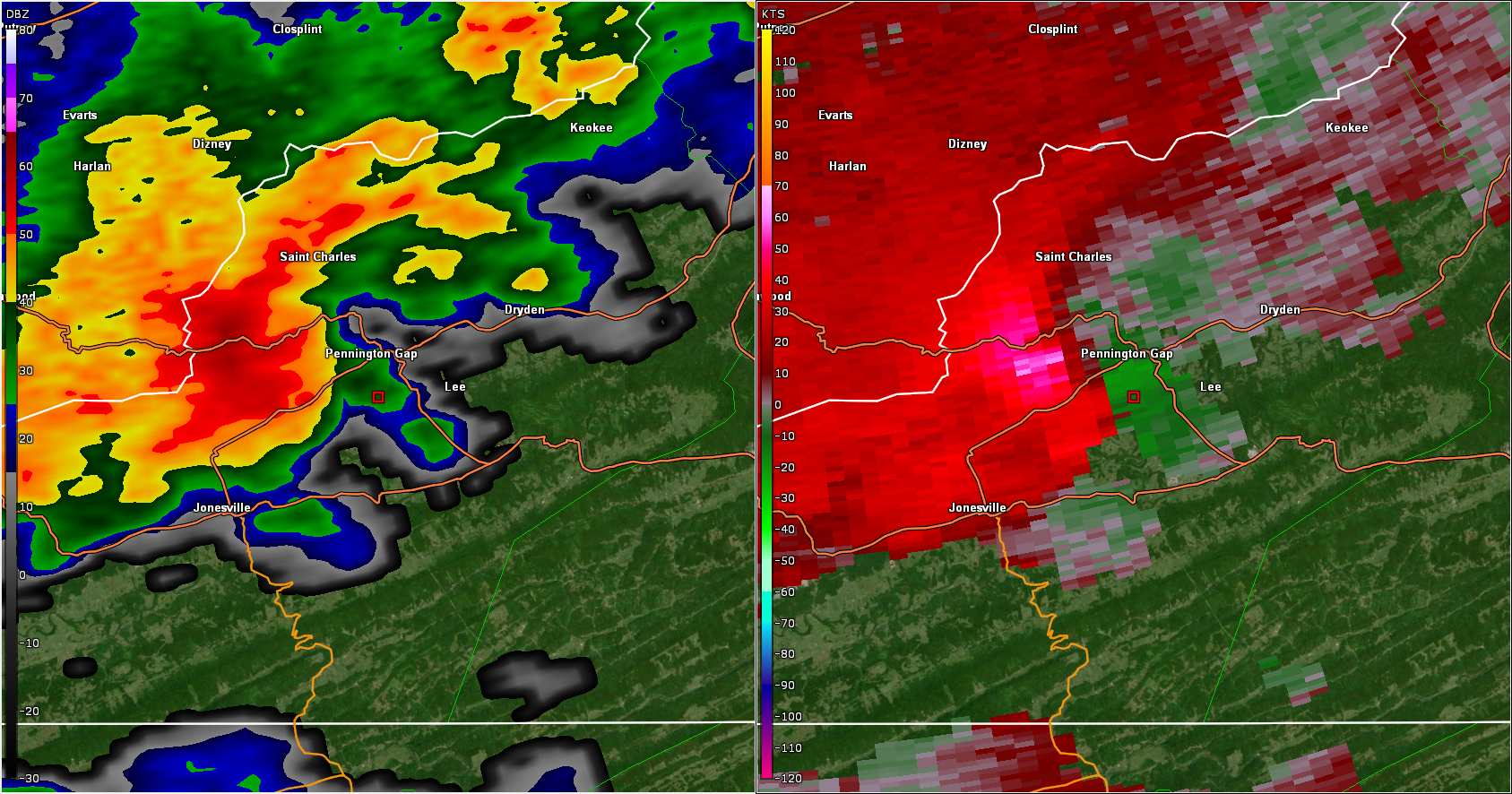 |
| Figure 1: Base Reflectivity and Base Velocity near Pennington Gap, VA from the Jackson, KY Radar |
This image shows the reflectivity (left) and base velocity (right) from the Jackson, Kentucky radar. The reflectivity image shows the leading edge of the storm “bowing” out, which is a signature of high winds surging forward. The velocity image shows a maximum velocity of 71 mph (bright pink colors). Keep in mind that at this distance from the radar, the radar is intersecting the storm about 4,000 feet above ground level. This pocket of high winds aloft was likely a rear-flank downdraft that descended to the ground a few minutes later, and produced the extensive wind damage south of Pennington Gap (near the red square). A damage survey estimated wind speeds at the ground of 70 to 90 mph. The velocity image also shows rotation just south of Pennington Gap (green beside red), which prompted the issuance of a tornado warning, but a tornado had not yet reached the ground at this time. Eyewitnesses near Pennington Gap reported that a funnel cloud was spotted. The descent of the rear-flank downdraft can sometimes be a precursor to a tornado touchdown. About 15 minutes later, a tornado touched down near Stickleyville, Virginia.
 |
| Figure 2: Base Reflectivity and Storm Relative Velocity near Stickleyville, VA from the Morristown, TN Radar |
This is an image taken from the radar in Morristown, Tennessee near the time that a tornado touched down near Stickleyville. The approximate location of the surveyed tornado is at the red square. The radar is viewing the storm about 3,200 feet above the ground, well above the tornado. This storm is showing some broad rotation aloft, as seen in the storm-relative velocity image on the right. This is a mesocyclone - a rotating updraft in the midlevels of a storm.
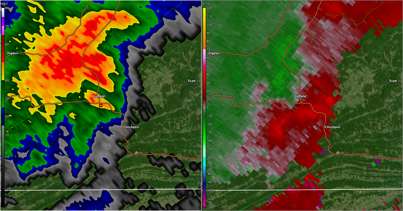 |
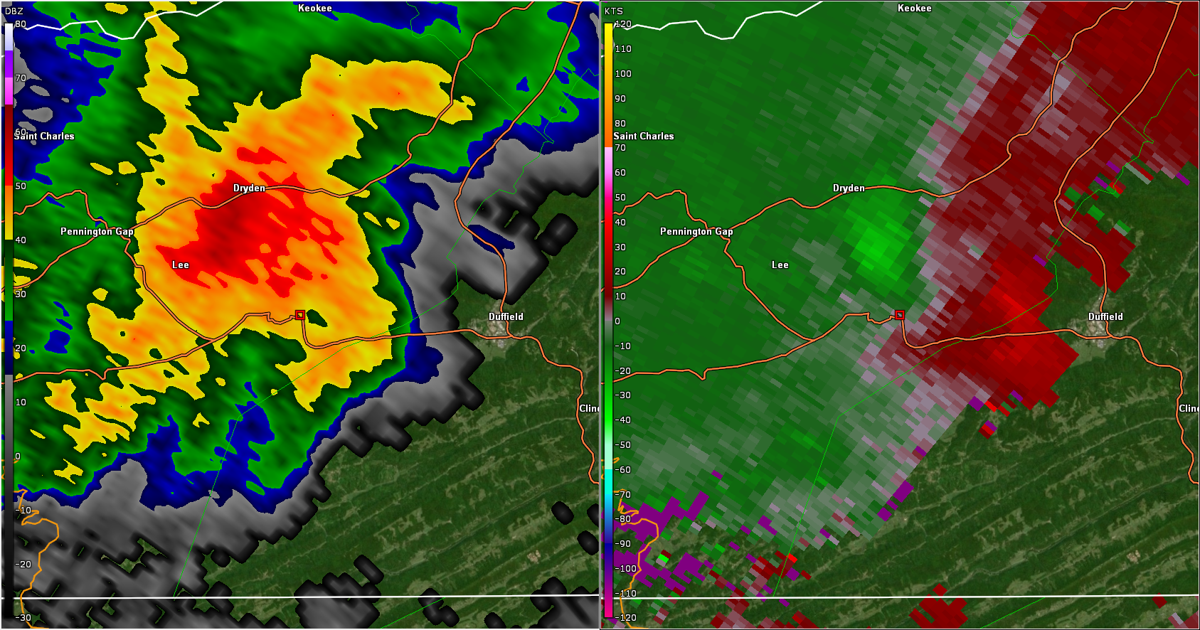
| Figure 3: Base Reflectivity and Storm Relative Velocity near Duffield, VA from the Morristown, TN Radar |
A tornado touched down south of Duffield, VIrginia, near the red square in the image. The storm-relative velocity image on the right shows rotation in the midlevels of the storms (about 3,600 feet above the ground), which is the mesocyclone and not the tornado. The radar beam is too high to detect the tornado on the ground.
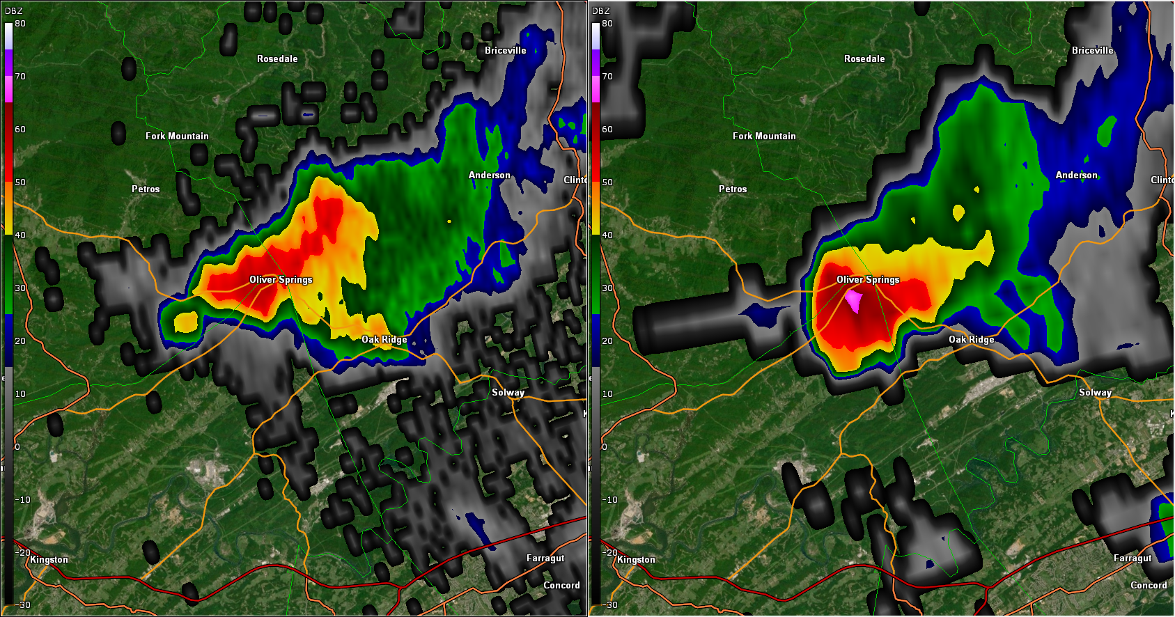 |
| Figure 4: Base Reflectivity in Anderson County, TN |
This storm produced quarter sized hail between Oak Ridge and Clinton around 4:30 pm EDT. The left image is reflectivity at about 7,500 feet above the ground, and the right image is reflectivity about 15,000 feet above the ground. This core of high reflectivity (pink area) in the midlevels of the storm is a hail core. The storm’s updraft is lofting the hail high into the storm, where temperatures are well below freezing, allowing hailstones to grow. Another interesting feature in this image is the area of low reflectivity extending out of the west side of the storm (gray and dark blue colors). This is called a three body scatter spike, or hail spike. It is a radar artifact that occurs when a portion of energy from the radar beam hits hail, is reflected off the hail to the ground, is reflected again from the ground to the hail, then is reflected back to the radar. Because of the extra time it takes for this energy to be reflected three times and returned to the radar (only a fraction of a millisecond), the radar displays this energy down radial of the storm’s hail core.
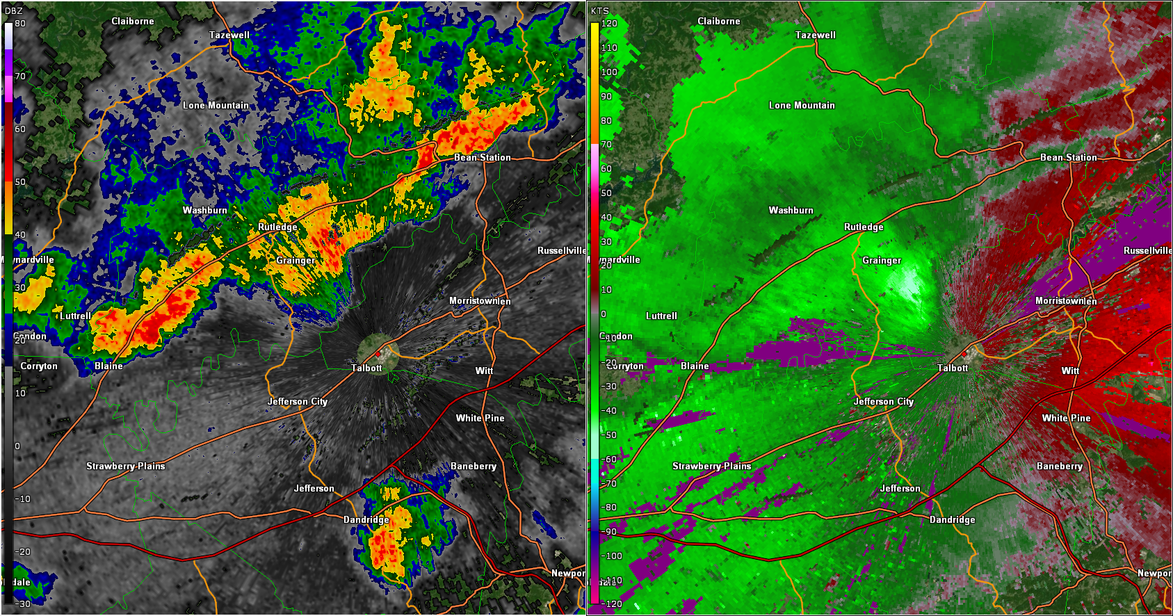 |
| Figure 5: Base Reflectivity and Base Velocity in Grainger/Hamblen Counties |
The close proximity of this storm to the KMRX radar (red dot near Talbott), allows for good detection of high winds close to the ground. The velocity image on the right is showing an area of high winds moving directly toward the radar, with a maximum speed of 63 mph. Trees and power lines were blown down by this storm near Joppa and Rutledge in Grainger County, and in Hamblen County near Alpha. The reflectivity image on the left shows the forward surge of outflow winds on the leading edge of the storm. A photo of this storm was taken from our office at 6:23 pm EDT, about the same time as this radar image.
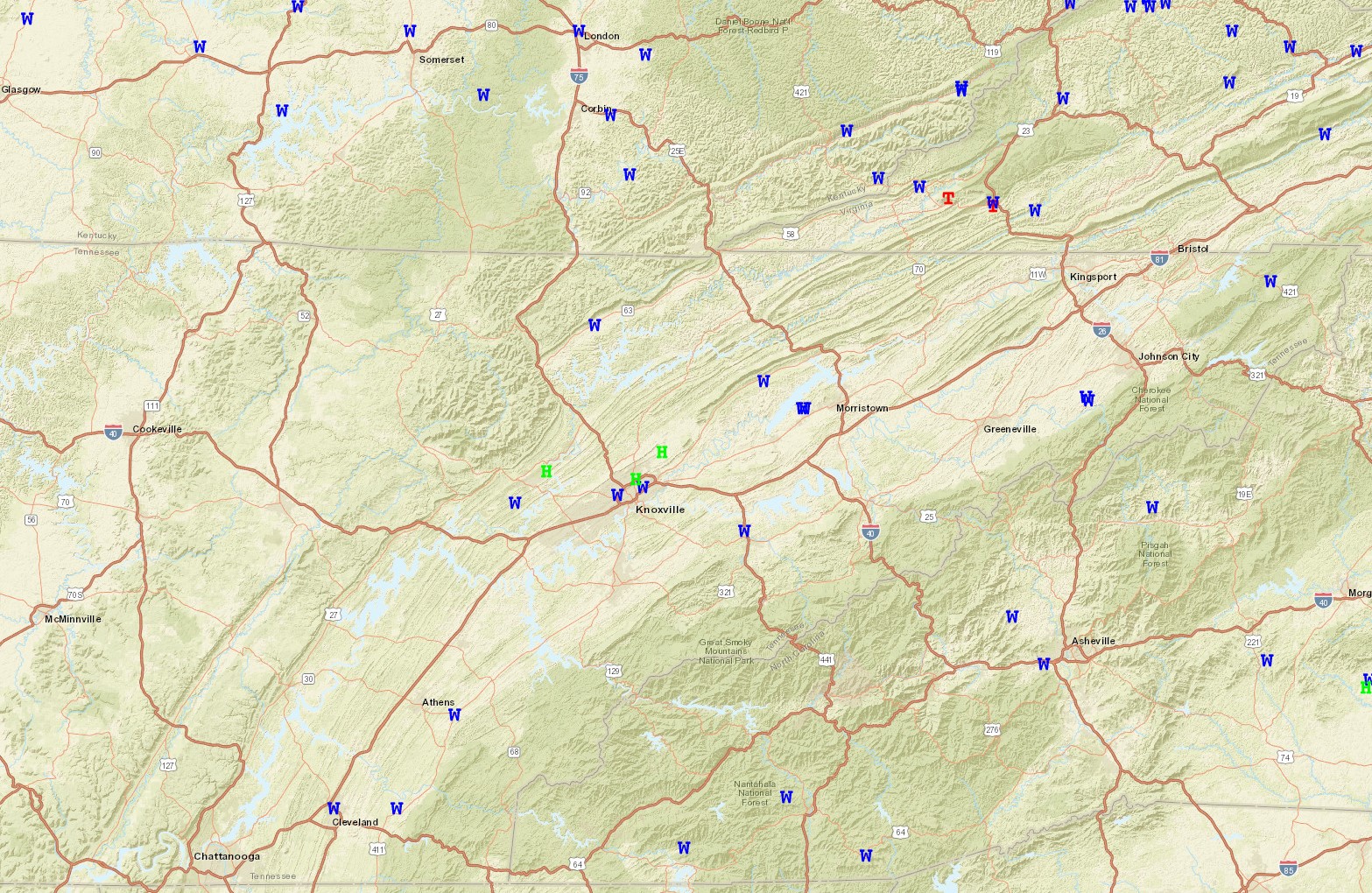
Storm Reports
W - Wind
H - Hail
T - Tornado
Public Information Statement
National Weather Service Morristown TN
725 PM EDT Wed May 17 2023

...NWS Damage Survey for May 16, 2023 Thunderstorm Wind Event
in Pennington Gap, Virginia...

A NWS survey team investigated damage in Pennington Gap, Virginia.
A 2.5 mile wide swath of damage was found on the south side
of town. Wind speeds were estimated between 70 and 90 mph.

&&

NOTE:
The information in this statement is preliminary and subject to
change pending final review of the event and publication in NWS
Storm Data.
PRELIMINARY LOCAL STORM REPORT...SUMMARY
NATIONAL WEATHER SERVICE MORRISTOWN TN
1041 AM EDT WED MAY 17 2023

..TIME...   ...EVENT...      ...CITY LOCATION...     ...LAT.LON...
..DATE...   ....MAG....      ..COUNTY LOCATION..ST.. ...SOURCE....
            ..REMARKS..

0350 PM     HAIL             MALONEYVILLE            36.09N 83.84W
05/16/2023  M1.00 INCH       KNOX               TN   PUBLIC

            REPORT FROM MPING: QUARTER (1.00 IN.).

0350 PM     HAIL             MALONEYVILLE            36.09N 83.84W
05/16/2023  U1.00 INCH       KNOX               TN   PUBLIC

            REPORT FROM MPING: QUARTER (1.00 IN.).

0403 PM     HAIL             15 NE KNOXVILLE         36.13N 83.76W
05/16/2023  M1.00 INCH       KNOX               TN   PUBLIC

            1 INCH HAIL IN CORRYTON, TN. TIME ESTIMATED
            FROM RADAR.

0403 PM     HAIL             15 NE KNOXVILLE         36.13N 83.76W
05/16/2023  M1.00 INCH       KNOX               TN   PUBLIC

            1 INCH HAIL IN CORRYTON, TN. TIME ESTIMATED
            FROM RADAR.

0420 PM     TSTM WND DMG     2 NNW ALPHA             36.20N 83.40W
05/16/2023                   HAMBLEN            TN   NWS EMPLOYEE

            TREES AND LARGE TREE LIMBS DOWN IN AND NEAR
            SEVEN OAKS SUBDIVISION.

0425 PM     HAIL             5 SW CLINTON            36.04N 84.20W
05/16/2023  E1.00 INCH       ANDERSON           TN   PUBLIC


0428 PM     HAIL             6 NE OAK RIDGE          36.03N 84.22W
05/16/2023  M1.00 INCH       ANDERSON           TN   PUBLIC

            SOCIAL MEDIA PICTURE OF QUARTER SIZE HAIL.
            EXACT LOCATION IN OAK RIDGE NOT PROVIDED.

0432 PM     HAIL             6 NE OAK RIDGE          36.03N 84.22W
05/16/2023  U0.70 INCH       ANDERSON           TN   PUBLIC

            REPORTED BY TRAINED SPOTTER.

0432 PM     HAIL             6 NE OAK RIDGE          36.03N 84.22W
05/16/2023  M0.70 INCH       ANDERSON           TN   PUBLIC

            REPORTED BY TRAINED SPOTTER.

0449 PM     HAIL             1 NW DANDRIDGE          36.04N 83.43W
05/16/2023  E0.70 INCH       JEFFERSON          TN   PUBLIC

            REPORTED BY TRAINED SPOTTER.

0449 PM     HAIL             1 NW DANDRIDGE          36.04N 83.43W
05/16/2023  E0.70 INCH       JEFFERSON          TN   PUBLIC

            REPORTED BY TRAINED SPOTTER.

0455 PM     HAIL             KARNS                   35.98N 84.12W
05/16/2023  M0.88 INCH       KNOX               TN   BROADCAST MEDIA


0500 PM     TSTM WND DMG     2 WNW KNOXVILLE         35.98N 83.98W
05/16/2023                   KNOX               TN   911 CALL CENTER

            3 TREES DOWN. ONE TREE ON TOP OF CAR.

0501 PM     TSTM WND DMG     ENGLEWOOD               35.42N 84.49W
05/16/2023                   MCMINN             TN   BROADCAST MEDIA

            ROOF DAMAGE TO BARN AND TREES DOWN. TIME
            ESTIMATED FROM RADAR.

0503 PM     HAIL             3 SW POWELL             35.99N 84.05W
05/16/2023  E0.70 INCH       KNOX               TN   PUBLIC

            .

0503 PM     HAIL             3 SW POWELL             35.99N 84.05W
05/16/2023  E0.70 INCH       KNOX               TN   PUBLIC


0515 PM     TSTM WND DMG     WISE                    36.98N 82.58W
05/16/2023                   WISE               VA   911 CALL CENTER

            TREES DOWN.

0525 PM     TSTM WND DMG     PENNINGTON GAP          36.76N 83.03W
05/16/2023                   LEE                VA   PUBLIC

            MULTIPLE TREES DOWN.

0530 PM     HAIL             3 NNE KNOXVILLE         36.02N 83.92W
05/16/2023  E1.00 INCH       KNOX               TN   TRAINED SPOTTER


0530 PM     TSTM WND DMG     DUFFIELD                36.72N 82.80W
05/16/2023                   SCOTT              VA   PUBLIC

            TREES DOWN.

0535 PM     TSTM WND DMG     FINCASTLE               36.41N 84.05W
05/16/2023                   CAMPBELL           TN   911 CALL CENTER

            TREES DOWN.

0545 PM     TSTM WND DMG     SEVIERVILLE             35.89N 83.58W
05/16/2023                   SEVIER             TN   911 CALL CENTER

            NUMEROUS TREES DOWN.

0550 PM     TSTM WND DMG     5 W HONAKER             37.02N 82.06W
05/16/2023                   RUSSELL            VA   911 CALL CENTER

            MULTIPLE TREES DOWN.

0600 PM     TSTM WND DMG     4 ENE CLINCHPORT        36.70N 82.67W
05/16/2023                   SCOTT              VA   PUBLIC

            SEVERAL TREES DOWN ACROSS THE COUNTY.

0615 PM     TSTM WND DMG     RUTLEDGE                36.27N 83.52W
05/16/2023                   GRAINGER           TN   911 CALL CENTER

            TREE DEWON IN RUTLEDGE.

0615 PM     TSTM WND DMG     1 ENE JOPPA             36.24N 83.60W
05/16/2023                   GRAINGER           TN   PUBLIC

            REPORT FROM MPING: 3-INCH TREE LIMBS BROKEN;
            POWER POLES BROKEN.

0635 PM     TSTM WND DMG     OAK RIDGE               35.96N 84.30W
05/16/2023                   ANDERSON           TN   911 CALL CENTER

            FEW TREES DOWN.

0635 PM     TSTM WND DMG     SHADY VALLEY            36.52N 81.93W
05/16/2023                   JOHNSON            TN   PUBLIC

            MULTIPLE TREES DOWN.

0640 PM     TSTM WND DMG     2 NNW ALPHA             36.20N 83.39W
05/16/2023                   HAMBLEN            TN   AMATEUR RADIO

            FEW TREES DOWN.

0643 PM     HAIL             2 SE HOPEWELL           35.21N 84.87W
05/16/2023  U0.75 INCH       BRADLEY            TN   PUBLIC

            REPORT FROM MPING: DIME (0.75 IN.).

0645 PM     TSTM WND DMG     1 NNW LOWLAND           36.16N 83.21W
05/16/2023                   HAMBLEN            TN   LAW ENFORCEMENT

            A FEW TREES DOWN.

0650 PM     TSTM WND DMG     CLEVELAND               35.18N 84.87W
05/16/2023                   BRADLEY            TN   911 CALL CENTER

            FEW TREES AND POWER LINES DOWN.

0656 PM     HAIL             2 S POWELL              36.00N 84.02W
05/16/2023  E0.25 INCH       KNOX               TN   PUBLIC


0656 PM     HAIL             1 NW KARNS              35.98N 84.13W
05/16/2023  M0.70 INCH       KNOX               TN   PUBLIC

            .

0656 PM     HAIL             1 NW KARNS              35.98N 84.13W
05/16/2023  M0.70 INCH       KNOX               TN   PUBLIC


0703 PM     TSTM WND DMG     1 W BENTON              35.18N 84.67W
05/16/2023                   POLK               TN   TRAINED SPOTTER

            MULTIPLE TREES DOWN.

0704 PM     HAIL             3 NW BEARDEN            35.97N 84.04W
05/16/2023  E0.25 INCH       KNOX               TN   PUBLIC

            REPORTED BY TRAINED SPOTTER.

0710 PM     TSTM WND DMG     2 WSW BENTON            35.17N 84.68W
05/16/2023                   POLK               TN   TRAINED SPOTTER

            TREES DOWN ACROSS ROADWAY.

0725 PM     TSTM WND DMG     4 NW EMBREEVILLE        36.23N 82.51W
05/16/2023                   WASHINGTON         TN   DEPT OF HIGHWAYS

            CORRECTS PREVIOUS TSTM WND DMG REPORT FROM 4
            NW EMBREEVILLE. A FEW TREES DOWN.

0725 PM     TSTM WND DMG     3 NE KNOXVILLE          36.00N 83.90W
05/16/2023                   KNOX               TN   911 CALL CENTER

            SEVERAL TREES DOWN.

0728 PM     FLASH FLOOD      3 NE KNOXVILLE          36.01N 83.91W
05/16/2023                   KNOX               TN   911 CALL CENTER

            FLOODING OF ROADWAYS.

0730 PM     HAIL             3 SW KARNS              35.94N 84.13W
05/16/2023  E0.25 INCH       KNOX               TN   PUBLIC

            REPORTED BY TRAINED SPOTTER.

0730 PM     FLASH FLOOD      1 SSE KNOXVILLE         35.96N 83.93W
05/16/2023                   KNOX               TN   PUBLIC

            REPORT FROM MPING: STREET/ROAD FLOODING;
            STREET/ROAD CLOSED; VEHICLES STRANDED.

0730 PM     FLOOD            MALONEYVILLE            36.09N 83.84W
05/16/2023                   KNOX               TN   PUBLIC

            REPORT FROM MPING: RIVER/CREEK OVERFLOWING;
            CROPLAND/YARD/BASEMENT FLOODING.

0740 PM     TSTM WND DMG     3 NW EMBREEVILLE        36.22N 82.50W
05/16/2023                   WASHINGTON         TN   DEPT OF HIGHWAYS

            CORRECTS PREVIOUS TSTM WND DMG REPORT FROM 3
            NW EMBREEVILLE. A FEW TREES DOWN.

0830 PM     TSTM WND DMG     TUSQUITEE               35.08N 83.77W
05/16/2023                   CLAY               NC   LAW ENFORCEMENT

            TREE DOWN. EXACT LOCATION UNKNOWN.
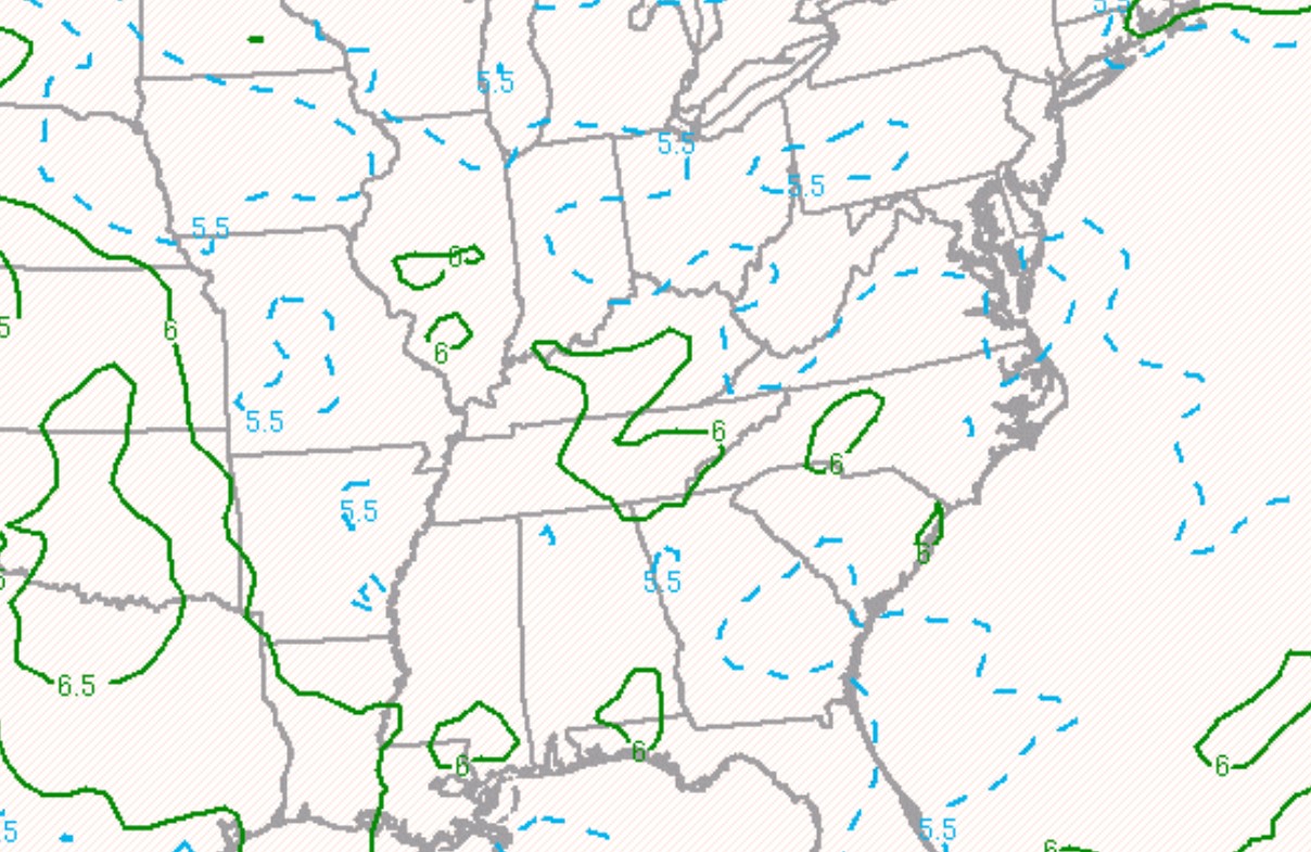
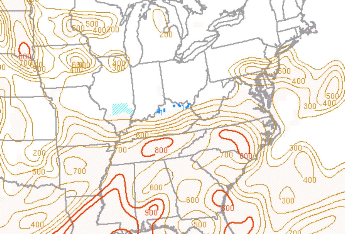
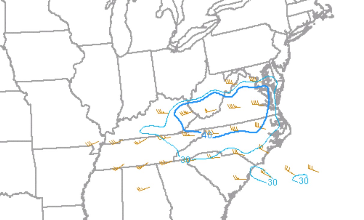
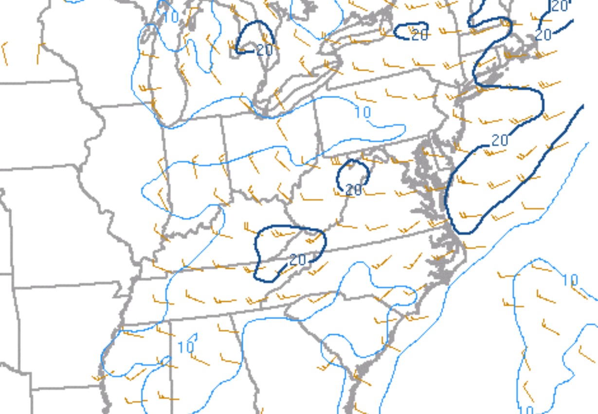
Environment
 |
 |
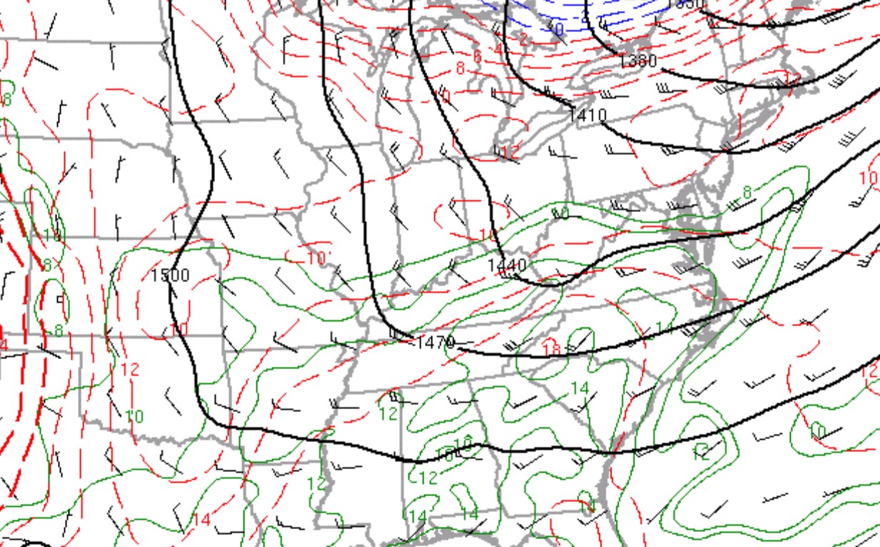 |
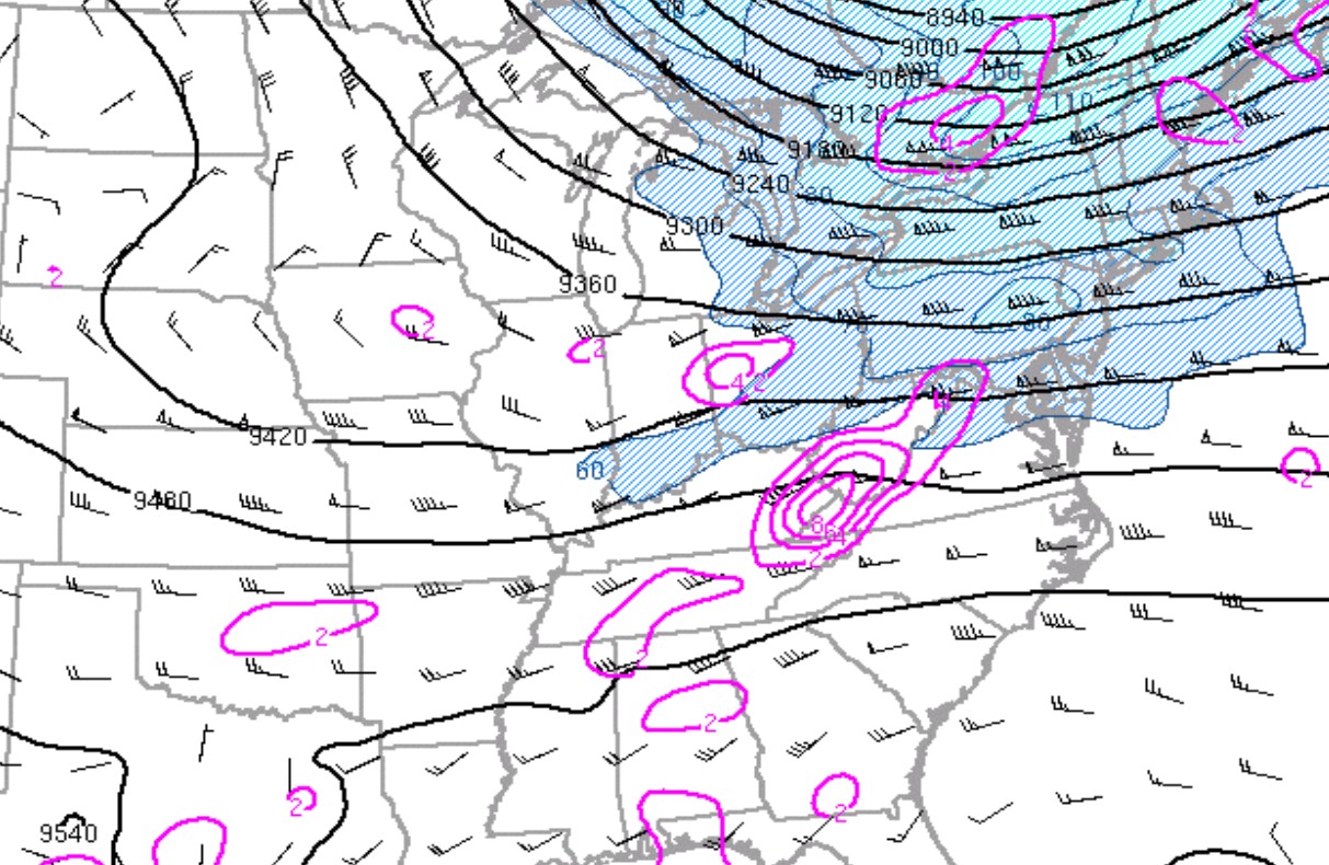
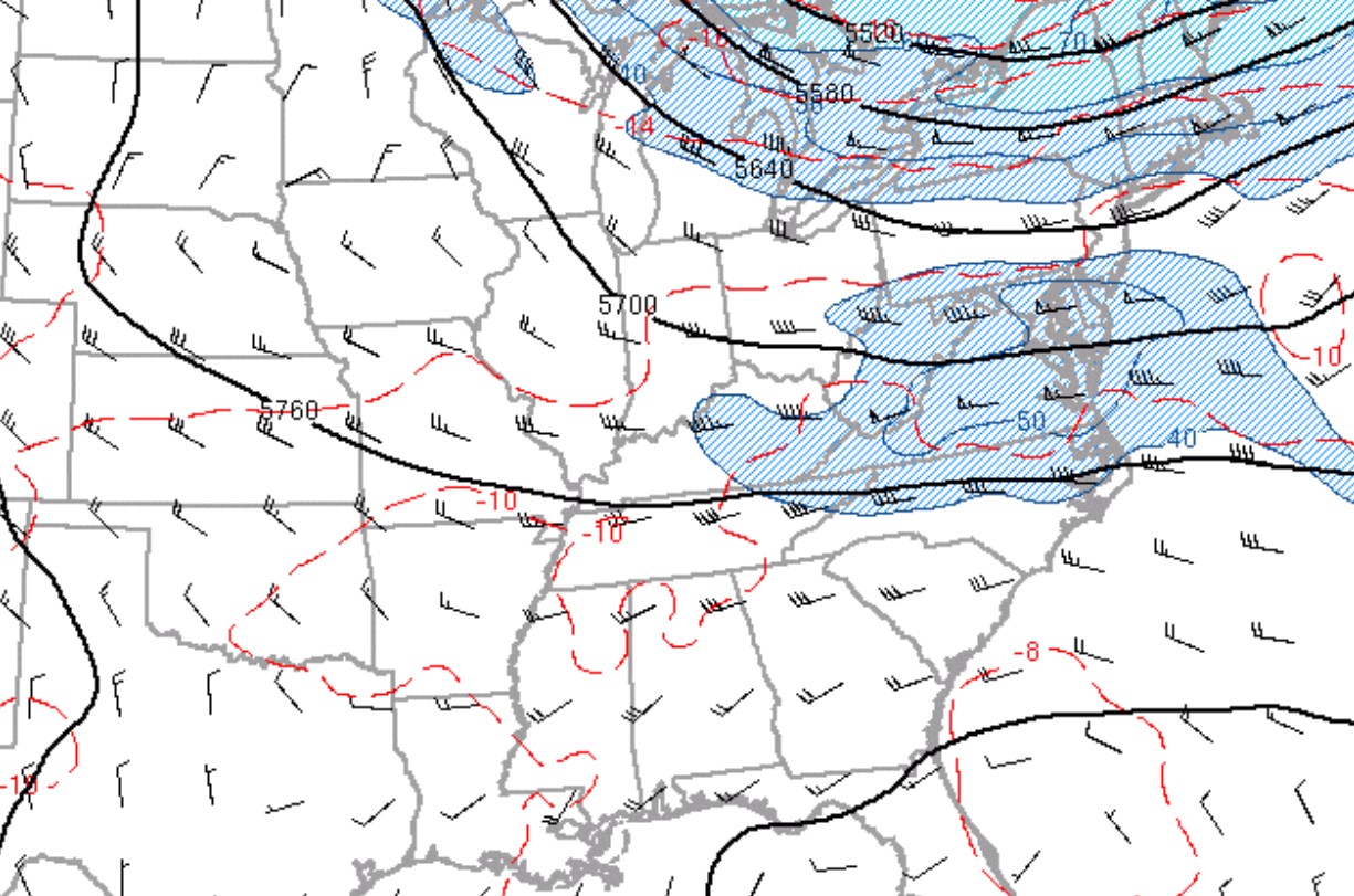
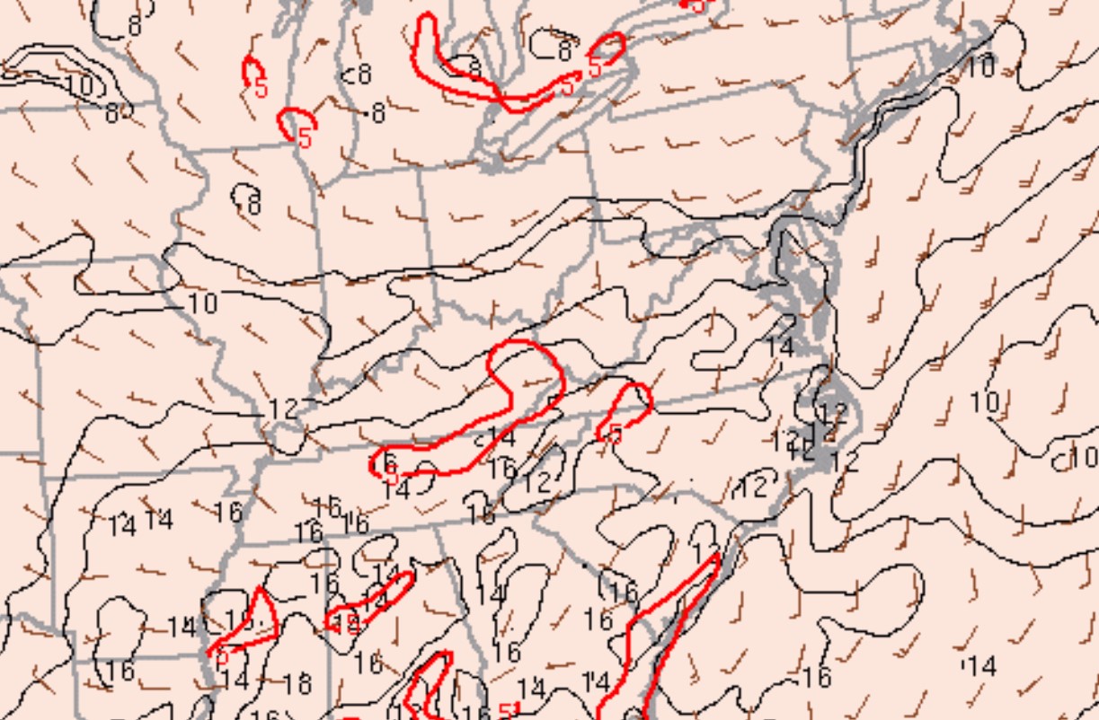
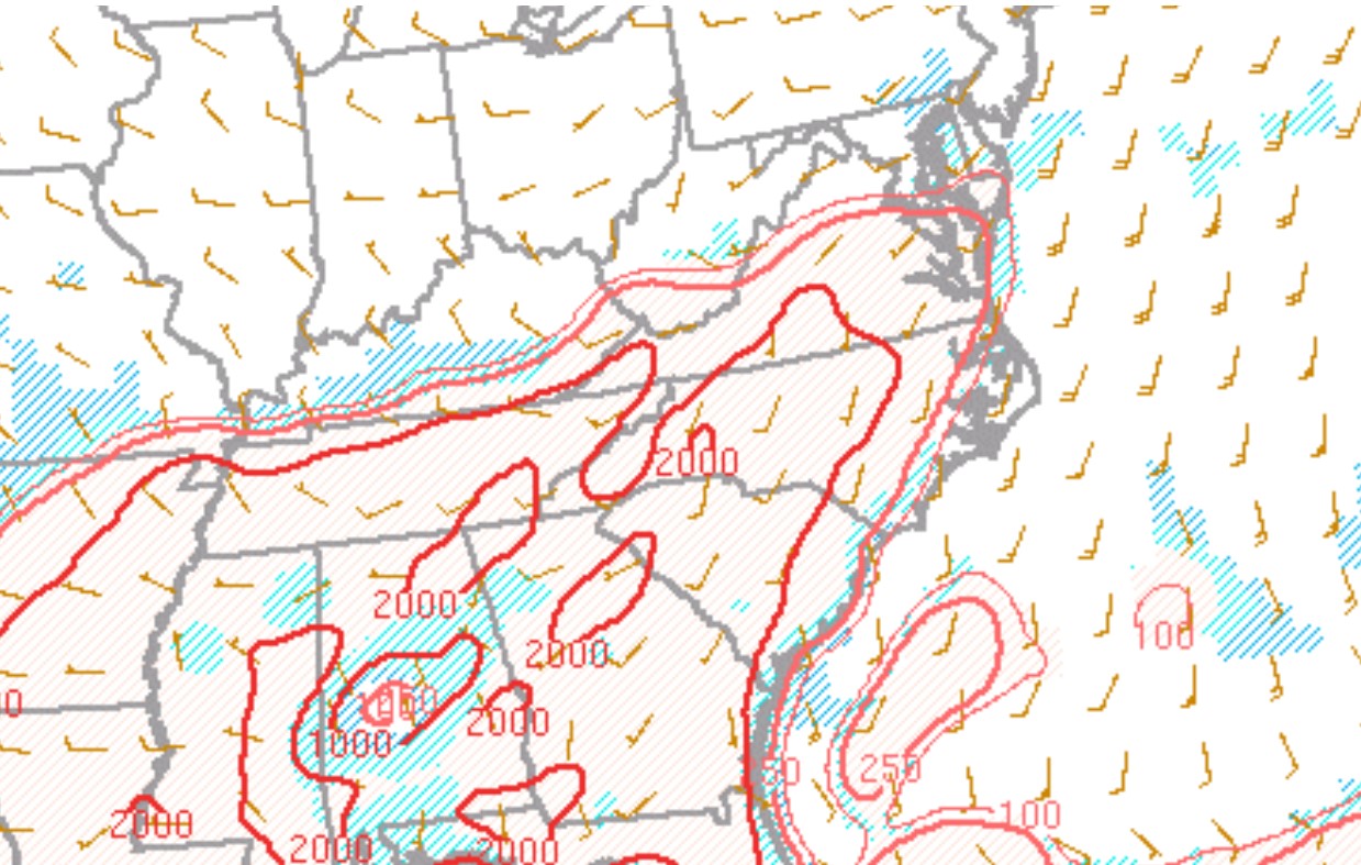
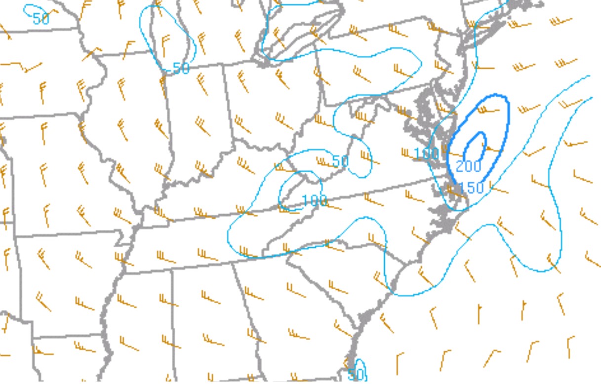
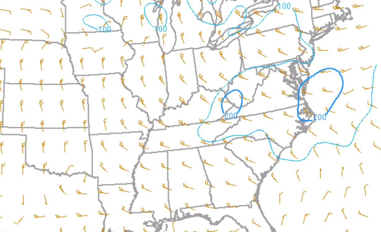
| Figure 1: 300mb Heights, Divergence, and Winds at 2200 UTC, 16 May 2023 | Figure 2: 500mb Heights, Temperature, and Winds at 2200 UTC, 16 May 2023 | Figure 3: 850mb Heights, Temperature, and Winds at 2200 UTC, 16 May 2023 |
An upper level jet across the lower Ohio Valley into the mid-Atlantic states produced large-scale forcing over the central and southern Appalachians into the eastern Tennessee valley. The 300mb analysis showed divergence aloft over southeast Kentucky, southwest Virginia and northeast Tennessee which aided in the development of storms.
The upper forcing enhanced the boundary layer jet over the eastern Tennessee valley and southern Appalachians with southwest winds of 30 kts. This low level jet pulled abundant moisture and instability into the central and southern Appalachians.
 |
 |
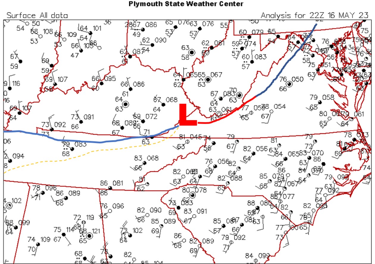
| Figure 4: Surface Station Plot at 2200 UTC, 16 May 2023 | Figure 5: Surface Moisture Convergence and Mixing Ratio at 2100 UTC, 16 May 2023 |
The surface analysis at 2200Z, May 16th 2023 showed an area of low pressure across southwest Virginia with a cold front extending west across northern Tennessee with a near stationary boundary east to northeast of the low over western Virginia.
Warm and moist conditions were noted south of the boundary across Tennessee with temperatures in the 80s and dewpoints in the 60s, much cooler air in Kentucky air-mass north of the boundary. A convergent wind field helped to focus the severe storms in this area during the late afternoon and evening hours.
Table 1: K1A6 (Middlesboro KY) surface observations on 16 May 2023
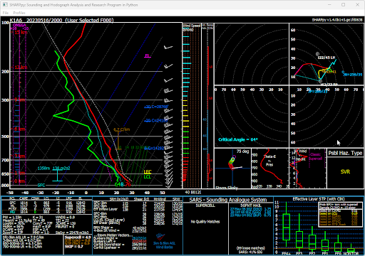
Figure 6: RAP Initialization Sounding at K1A6 (Middlesboro KY) at 2000 UTC, 16 May 2023
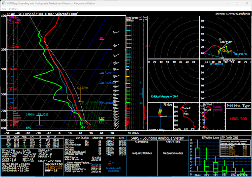
Figure 7: RAP Initialization Sounding at K1A6 (Middlesboro KY) at 2100 UTC, 16 May 2023
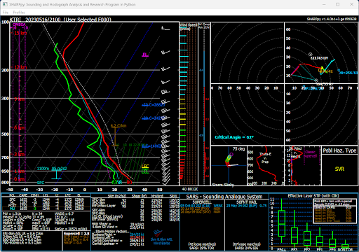
Figure 8: RAP Initialization Sounding at KTRI (Tri-City Airport TN) at 2100 UTC, 16 May 2023
The K1A6 (Middlesboro, KY) and KTRI (Tri-City Airport) RAP initialization soundings at 20 and 21 UTC, 16 May 2023 were utilized to diagnose the environment near the Lee County, Virginia tornado.
The soundings depicted a marginally unstable environment with CAPES of 1000 J/Kg and low-level CAPE over 100+ J/Kg. Lifting Condensation Level (LCL) of 900-1000 meters. The effective storm scale shear was in the middle and upper 30s knots with the 0-1 km shear of 15 to 20 knots. Overall, a marginal environment for tornadoes across southwest Virginia. The K1A6 (Middlesboro, KY) surface observations depicted a backing of the surface winds ahead of the storm which likely enhanced the low-level shear within this area.
However, the favorable low-level CAPE and close proximity of surface low and stationary boundaries across southwest Virginia likely improved the near storm environment.
 |
 |
 |
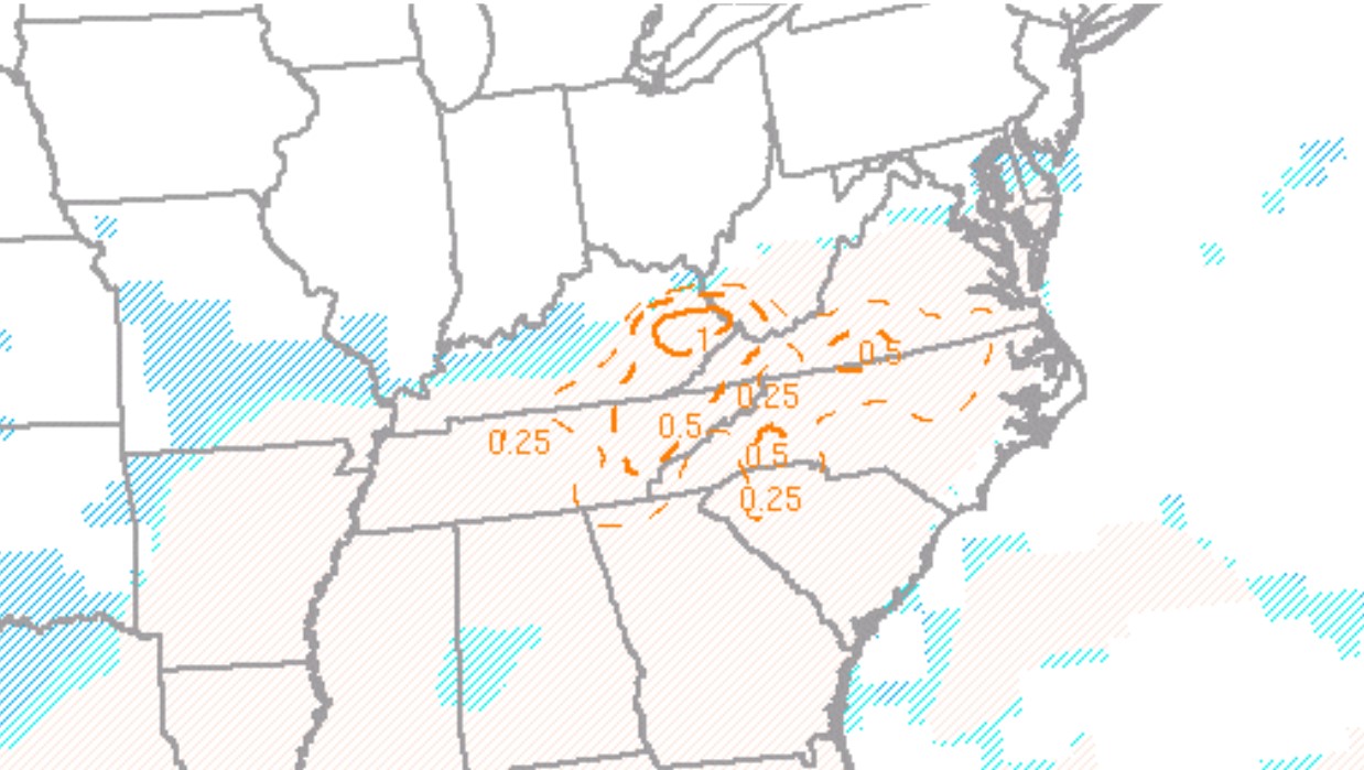
| Figure 9: MLCAPE and CIN at 2200 UTC, 16 May 2023 | Figure 10: 0-3 km MLCAPE and Surface Vorticity at 2000 UTC, 16 May 2023 | Figure 11: CAPE (-10 to -30 C), Freezing Level, and 0-6 km Shear at 2000 UTC, 16 May 2023 |
 |
 |
 |
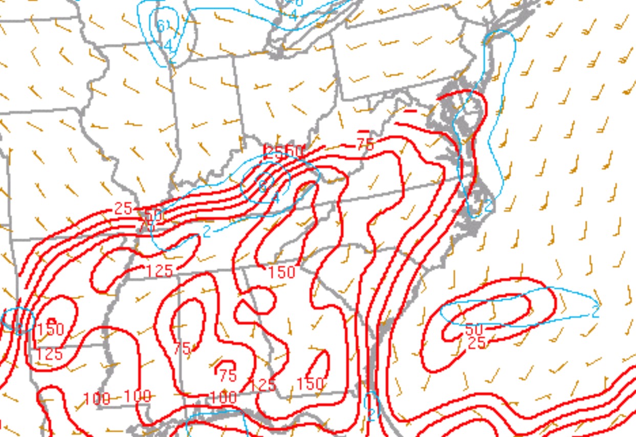
| Figure 12: Mid-Level Lapse Rates (700-500mb) at 2200 UTC, 16 May 2023 | Figure 13: DCAPE and DCIN Mid-Level Lapse Rates (700-500mb) at 2200 UTC, 16 May 2023 | Figure 14: Effective Shear at 2200 UTC, 16 May 2023 |
 |
 |
 |
| Figure 15: 0-1 km Shear at 2200 UTC, 16 May 2023 | Figure 16: 0-1 km Storm Relative Helicity at 2200 UTC, 16 May 2023 | Figure 17: 0-3 km Storm Relative Helicity at 2200 UTC, 16 May 2023 |
 |
 |
 |
| Figure 18: Supercell Composite Parameter (SCP) (effective layer with muCIN) and Bunkers Storm Motion at 2000 UTC, 16 May 2023 | Figure 19: Significant Tornado Parameter (effective layer) and MLCIN at 2000 UTC, 16 May 2023 | Figure 20: Derecho Composite Parameter (effective layer) and MLCIN at 2000 UTC, 16 May 2023 |
 |
| Figure 21: SHERBE (0-3 km LR, EBWD, and 700-500 mb LR) at 2000 UTC, 16 May 2023 |
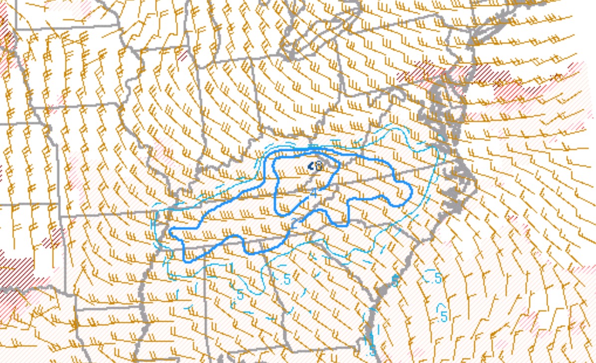
The SPC mesoanalysis depicted an unstable environment with MLCAPES of 1000-2000 J/Kg. As noted above the 0-3 km MLCAPE was quite high with values of 100-150.
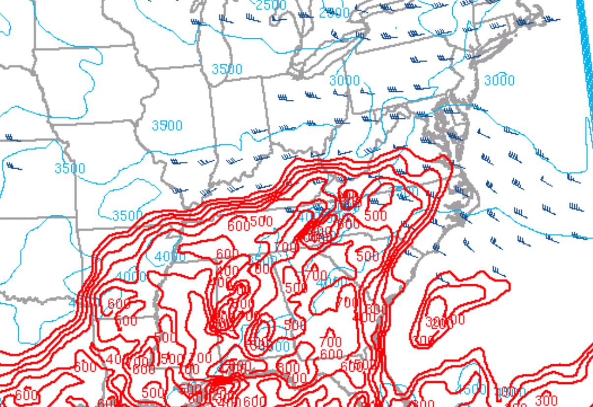
Even though the mid-level lapse of 6 degree C was at best marginal favorable, Hail CAPES of 500-700 J/Kg and effective storm scale shear in the 30s to near 40 knots produced an environment for favorable hail growth and resident time for severe hail.
Downdraft CAPES of 700-800 J/Kg and a low-level jet up to 30 knots were sufficient to produce damaging straight line winds and/or downbursts with the storms. This was also noted with the Derecho Composite Parameter (DCP) values of 2+.
The Supercell Composite Parameter (SCP) and Significant Tornado Parameter depicted an overall favorable environment for rotating storms across much of the area with the greatest potential of tornadoes over southwest Virginia and far northeast Tennessee. The SHERBE composite parameter also noted this area as the highest concern for low CAPE and high Shear tornadoes.
 |
Media use of NWS Web News Stories is encouraged! Please acknowledge the NWS as the source of any news information accessed from this site. |
|


 Local Radar
 Huntsville Radar
 Regional Satellite
 Graphical Forecast
 Weather Map