
Dangerous and extreme heat will remain across portions of the central U.S. this week, persisting across the mid to lower Mississippi Valley, Gulf Coast, southern Plains and portions of Texas. A heat wave over the Southwest U.S. will peak this weekend. Heavy to excessive rainfall may produce flash flooding from the Delmarva Peninsula north into the Hudson Valley today and tonight. Read More >
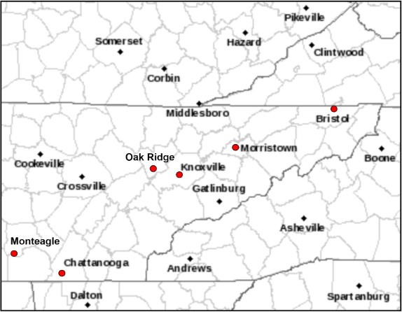
The Knoxville, Tennessee weather service office was opened in 1871 and operated by the U.S. Army Signal Service. The Department of Agriculture’s Weather Bureau Office (WBO) took over in 1891. The WBO was moved several times across the city of Knoxville, Tennessee. Here are the dates and locations:
|
Dates |
Locations |
|
January 1 to 20, 1871 |
Doctor Ludlow’s house |
|
January 21, 1871 to August 25, 1877 |
East College, East Tennessee University |
|
August 26, 1877 to July 15, 1897 |
U.S. Custom House and Post Office |
|
July 16, 1897 to June 18, 1907 |
Old College, University of Tennessee |
|
June 18, 1907 to May 18, 1917 |
Van Deventer Building, 311-313 Wall Avn. |
|
May 18, 1917 to Sept 19, 1932 |
Brownlow (Henson) Building, 311 Market St. |
|
Sept 19, 1932 to March 13, 1934 |
New Sprankle Bldg., 508 West Union Avenue |
|
March 13, 1934 to Feb. 28, 1942 |
U.S. Post Office & Court House, Corner of Main & Walnut Streets |
|
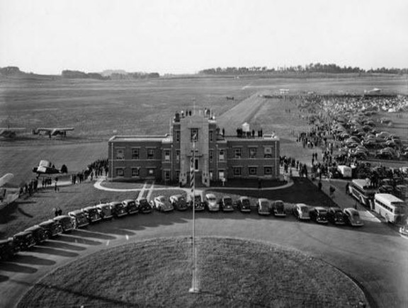
March 1, 1942 to Nov. 11, 1981 |
2nd Floor Adm. Bldg., Knoxville Municipal (McGhee Tyson) Airport |
|
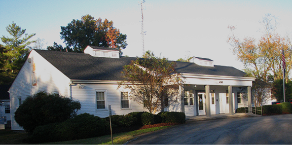
Nov. 11, 1981 to March 18, 1997 (closure) |
Weather Service Office, back side of the Knoxville Municipal airport on Airbase Road. |
The Tennessee Valley River Forecast Center was established around 1950, but was downgraded to a Water Supply Forecast Unit in 1957 and closed in 1959. The Knoxville Weather Service Office was closed in 1997, with its functions transferred to the new NWS office in Morristown, Tennessee.
The Bristol Weather Bureau Airways Station (WBAS) Weather Service Office (WSO) was opened in 1944 at the Tri-Cities Regional Airport. The U.S. Weather Bureau took over operations at the weather station on St. Patrick’s Day 1944. The office was closed on the midnight shift of September 1953, but then reopened to full-time operations in November 1959. A Weather Service Radar (WSR)-57 network radar was commissioned on May 25, 1972. The Weather Service Office was closed and operations transferred to the Weather Service Forecast Office at Morristown, Tennessee in 1995.
The Chattanooga, Tennessee weather service office was opened at the Hamilton County Courthouse in 1879 and operated by the U.S. Army Signal Service. The Department of Agriculture’s Weather Bureau Office (WBO) took over operations in 1893 and moved to the U.S. Customs House. The office relocated to the James Building in downtown Chattanooga in 1909, then the post office in 1934. In July 1940, the main office was relocated to Lovell Field, Chattanooga Airport. At the time, a separate office at the post office processed observational forms from around the country, remaining open through at least 1956. A Weather Service Radar (WSR)-74C radar was installed at the airport in the 1980's, and decommissioned in 1998. The office was closed in 1998, and observations were transferred to a federal contract.
Biographical story of Mr. William F. Reed, Jr., WBO, Chattanooga, TN,
https://www.history.noaa.gov/stories_tales/reedwea.html
The Oak Ridge Weather Bureau Research Station (USWB) Office was opened in 1948. The special Weather Bureau office was opened to support the work of the U.S. Atomic Energy Commission. In the mid 1960’s, operations were transferred to the new Atmospheric Turbulence and Diffusion Laboratory, which later became part of NOAA’s Air Resources Laboratory.
The Monteagle Weather Bureau Office was open from 1942 to 1946. The main purpose of the office was to support Air Commerce for the Federal Aviation Administration (FAA).
The Morristown Weather Forecast Office (WFO) was opened in 1994 with the Weather Service Radar (WSR)-88D installed and accepted in late August 1994. The office spun-up operations in 1995 taking over warning responsibilities for the Tri-Cities, Knoxville, and Chattanooga areas. The Morristown office was dedicated on August 11, 1995.
The forecast responsibilities were transferred from the Weather Service Forecast Office in Memphis, Tennessee to Morristown in 1999. The Morristown, Tennessee WFO is responsible for issuing forecasts, watches and warnings for East Tennessee, parts of southwest Virginia, and parts of southwest North Carolina.
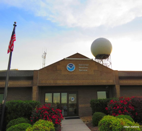
If you would like more information about Morristown, Tennessee WFO, please go to the following website: https://www.weather.gov/mrx/office
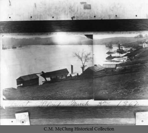
One of the most significant flood events ever recorded in East Tennessee is the Flood of 1867. Due to the mountainous terrain and valleys across East Tennessee, the Upper Tennessee Valley is especially susceptible to flooding. The Tennessee River flows down the Tennessee Valley with nearly all of the precipitation runoff flowing through the Chattanooga, Tennessee area.
The Tennessee valley has been susceptible to significant flooding in the past, especially before the Tennessee Valley Authority (TVA) built a series of dams. The flood of 1867 was historic and impacted countless lives along the rivers and streams of east Tennessee, but the Chattanooga area was especially hit hard.
In 1867, the Tennessee River at Chattanooga was usually about 643 feet above sea level at the measuring gauge beneath the Walnut Street Bridge, and flood level was 30 feet above that, or about 673 feet. Much of the land in the Chattanooga area is only 660 to 670 feet above sea level, with only a few areas of higher ground on Cameron Hill, Orchard Knob, McCallie Avenue, and in what is now the museum district of downtown.
At the peak of the historic flooding of 1867, the Tennessee River crested at 701 feet above sea level which is nearly 58 feet above normal. This crest placed much of the Chattanooga area under 25 to 30 feet of water.
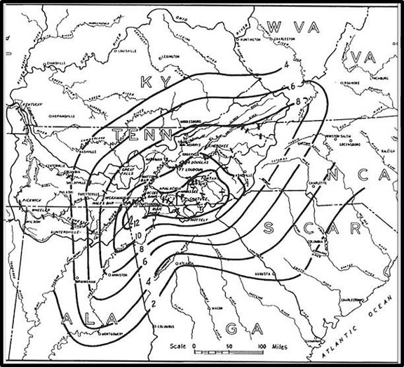
The heavy rain that caused the flooding occurred between March 1-7, 1867. Rapid snow melts across the higher elevations of the southern Appalachian Mountains contributed to the runoff. Meteorological data was scarce in 1867, but the Tennessee Valley Authority reconstructed the precipitation amounts across the southern Appalachians.
For more information about the 1867 Chattanooga Flood, go to the following website:
https://en.wikipedia.org/wiki/1867_flood_of_Chattanooga
Another major flood occurred across East Tennessee from April 30 through May 4, 2003. For information about this flood event, please go to the following location:
https://www.weather.gov/mrx/may03flood.
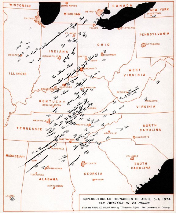
The Tornado Outbreak of April 3-4, 1974 was one of the biggest and deadliest tornado outbreaks across the nation and Tennessee. From the afternoon of April 3 until the early morning hours of April 4, a total of 148 tornadoes were reported across the Midwest to the Ohio and Tennessee valleys with more than 330 people killed. In East Tennessee, a total of 16 tornadoes were reported. Some of the more devastating tornadoes occurred in Etowah, Maryville, and Newport, Tennessee. A strong tornado occurred in Knox County hitting a mobile home park killing two people.
For more information about the 1974 Super Outbreak:
https://en.wikipedia.org/wiki/1974_Super_Outbreak
Revisiting the 3-4 April 1974 Super Outbreak of Tornadoes
https://www.spc.noaa.gov/publications/corfidi/74superoutbreak.PDF
On March 12-14, 1993, a massive storm system moved northeast from the Deep South across the southern Appalachians to the northeast United States. The storm system brought blizzard conditions across much of Appalachians including East Tennessee. The strength of the storm system spanned tornadoes in the deep south, coastal flooding, crippling snow and blizzard, and bone chilling temperatures in its wake. The total cost of the storm damage was $5.5 billion which would be $9.8 billion in 2019 dollars.
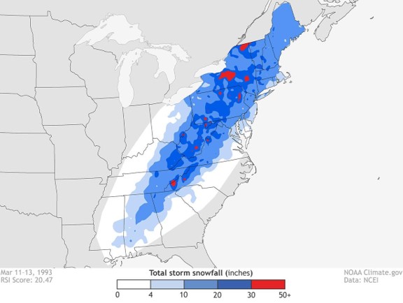
For East Tennessee, most locations in the valley received between 1 and 1 ½ feet of snow with the Knoxville airport officially recording 15 inches. The mountains of East Tennessee received a lot more snowfall with Mount LeConte buried with under 60 inches of snow. Besides the snow, the high winds associated with the storm produced high drifts across the area making travel impossible and hazardous.
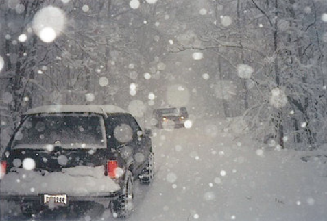
The storm stranded hikers in the Smoky Mountains, knocked out power to thousands for days, and stranded people in their homes for days. Law enforcement and emergency crews worked long hours to help people in need, and even the National Guard was called upon to use helicopters to drop food and supplies to stranded people.
For more information about the 1993 Storm of the Century, please go to the following website: https://www.ncei.noaa.gov/news/1993-snow-storm-of-the-century.
On April 27, 2011, a historic outbreak of tornadoes occurred across the southeast United States including East Tennessee and southwest Virginia. A total of 316 fatalities occurred that day with 32 in Tennessee. Nationwide, 199 tornadoes developed across 14 states. Across East Tennessee, near 50 tornadoes were reported with 13 rated as strong tornadoes. The deadliest tornadoes occurred in Collegedale, Tennessee with 13 fatalities and Camp Creek, Tennessee with 6 fatalities.
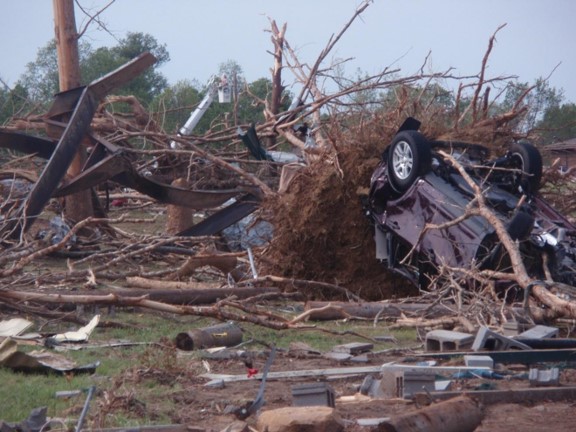
There was a narrow miss in Blount County when an Enhanced Fujita (EF) 4 tornado struck an isolated area of the Great Smoky Mountain National Park. This tornado was around 15 miles long and a quarter mile wide, uprooted trees and snapped large power lines near the Chilhowee Dam.
Besides the tornadoes, the storms produce widespread hail damage. People reported up to baseball sized hail with these storms. Hundreds of residents reported significant damage to homes and vehicles after the hail storm.
A memorial stands in Greene County to those killed in two quiet, rural communities. It was dedicated on the one-year anniversary of the storms.

For more information about the Super Tornado Outbreak of April 27, 2011, please go to the following website: https://en.wikipedia.org/wiki/2011_Super_Outbreak


 Local Radar
 Huntsville Radar
 Regional Satellite
 Graphical Forecast
 Weather Map