NOAA/NWS 1982 Marion, IL F4 Tornado Web Site
| Home | Storm Path | Weather | Photos | Heroes |
| Then / Now | Safety | Memorial | Credits | Contact Us |
On May 29, 1982, a deadly F4 tornado carved a 17-mile long path across Williamson County, Illinois, including the city of Marion. At times, the tornado was nearly a quarter mile wide. The tornado first touched down about 3 miles northwest of Carterville around 3:05 p.m. After moving southeast across Carterville to Crainville, the twister then paralleled Illinois Route 13 through Marion. On the ground for nearly 30 minutes, the tornado claimed 10 lives in Marion, injured nearly 200, and left approximately 1,000 persons homeless across Williamson County.
What follows is the description of the tornado's path taken from the May 1982 issue of Storm Data, a monthly publication of the National Climatic Data Center in Asheville, North Carolina.
"Ten persons were killed and 181 persons were injured when a massive tornado cut a path through 3 towns in Williamson County and contained 3 separate vorticies rotating around the main tornado. The initial touchdown was approximately 4 miles northwest of Carterville and 1 mile north of Crab Orchard Lake. It lifted briefly, touching down in a subdivision of Carterville demolishing 2 homes and causing damage to several others. The tornado again lifted briefly and touched down again in downtown Carterville. It traveled through the east section of town and through Crainville where several homes, business buildings and many trees were damaged. The tornado then increased in size and several funnels were observed within the tornado. Extensive damage occurred at the Williamson County Airport between 1410 and 1415 CST. Then the tornado either changed course or formed a new funnel as it followed highway 13 through Marion. A truck plaza near Interstate 57 in western Marion was demolished. A car was struck on Interstate 57 and exploded. A motel and 3 shopping centers were damaged. Two of the 39 motel occupants were injured. The Shawnee Village 190 unit apartment complex was destroyed and 2 schools were severely damaged. One person died when a wall fell and 2 more died when they were literally blown out of their homes. In Marion a total of 161 homes and 47 businesses were destroyed; 59 homes and 29 businesses suffered damage. In Williamson County, 52 businesses were destroyed and 37 were heavily damaged. In total, 648 homes were damaged with 40% of these destroyed and 23% suffering major damage. Many persons were trapped under rubble. Over 200 cars were damaged or destroyed. The tornado lifted approximately 1 mile east-southeast of Routes 166 and 13; and the estimated damage was between 85 to 100 million dollars. The total homeless was approximately 1,000."
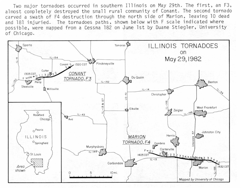
Also from the May 1982 issue of Storm Data is a map of the damage path for both the Conant F3 and Marion F4 tornadoes. Both were mapped on June 1, 1982, from a Cessna 182 by Duane Stiegler, University of Chicago. Click on the thumbnail below for a larger image.
In the days following the event, a very extensive damage assessment survey of the Williamson County tornado was conducted by Mr. Bob Hamilton, Meteorologist-In-Charge of the St. Louis NOAA National Weather Service Forecast Office in 1982. Click here to view the highlights of this report.
The official May 1982 Storm Data report was compiled by the NOAA National Weather Service Forecast Office in St. Louis, and published by the National Climatic Data Center in Asheville, North Carolina. Click here for excerpts from this report related to the Williamson County tornado. You will need a PDF reader to view this report. You may alternatively view most of this report in sections by visiting the Photos page on this site.


 Follow us on YouTube