| Home | Storm Path | Weather | Photos | Heroes |
| Then / Now | Safety | Memorial | Credits | Contact Us |
Report on Marion and Williamson County Tornado, Saturday, May 29, 1982
"A killer tornado touched down in western Williamson County between 3:05 and 3:10 PM, causing over 85 million dollars damage, killing 10 persons and injuring at least 181 others. The damage path was approximately 15 miles long with a variable width of 100 feet at first touch down to 300 yards within the Marion City 1imits. More than one funnel was reported especially in the early and final stages of the tornado.
The first tornado damage occurred in a subdivision area of Carterville just west northwest of John Logan Junior College and 1 1/2 miles east of Crab Orchard Lake. Some treetop damage was noted to the west of this touch down point. After demolishing 2 houses and minor damage to other homes in a subdivision, it lifted. It then touched down briefly in downtown Carterville, in East Carterville and in Crainville damaging some homes, business buildings and many trees. Just east of Crainville, it increased in size, lowered to the ground and remained on the ground until it reached east of Marion. From the junction of old Route 13 and new Route 13, east of Marion, to Route 166, three separate damage paths were noted; two paths were north of Route 13 and one south of Route 13 near Route 166. *See attached drawing.
It is also possible that there were more than one funnel in the early stages of the tornado. The damage path was a little erratic and a few observers reported seeing more than one funnel. At Williamson County Airport, the damage path jumped from north of Route 13 to south of Route 13. It was reported that one funnel dissipated north of Route 13 at the edge of the airport and another funnel formed and touched down just south of Route 13. The tornado was in the vicinity of the Williamson County Airport (MWA) between 3:10 and 3:15 PM. The weather observer at MWA logged his first sighting to the southwest at 3:10 PM. Carol Abrams, Weather Reporter for Herrin Radio Station WHPI, viewed the tornado from her second story office and issued a warning at 3:08 PM over WHPI when she first saw the funnel cloud. She estimated the base of the funnel to be about 80 feet up, just east of Crainvi11e at 3:12 PM. This would put it just west of MWA. Tom Redickas, Williamson County and Marion ESDA Coordinator, reported the funnel being sighted from the Ordil ESDA Office at 3:12PM.
From the Williamson County Airport, the tornado either changed course or formed a new funnel south of Route 13. It followed Route 13 into and through Marion causing nearly total destruction in a 50 to 100 yard wide path and severe to partial destruction in a 100 to 300 yard wide path. There is some disagreement on the time that it entered and moved out of Marion but it appears it was visible to Marion residents around 3:16 PM with some power outages reported at 3:16 PM. It also appears that the tornado moved through West Marion between 3:25 and 3:30 PM then through East Marion between 3:30 and 3:35 PM. The sheriff's office downtown lost power at 3:30 PM.
The tornado damage path became more narrow and less severe in extreme East Marion and lifted east of Marion just after it crossed to the north of Route 13. A second funnel touched down about 2 miles east of Marion and followed a cyclonically curved path just north of Route 13. This was not the same funnel that moved through Marion. Several homes and buildings were destroyed. A third funnel touched down just south of Route 13 and lifted at Route 166. Several houses and buildings were damaged with one house complete1y destroyed.
DAMAGE
In Williamson County, the estimate was 52 businesses destroyed and 37 heavily damaged. A total of 648 homes were damaged by the tornadoes with 40 percent of those destroyed and another 23 percent with major damage.
In Marion, 49 businesses were damaged or destroyed. Three shopping centers were hit and two schools were severely damaged.
DEATHS
Ten persons lost their lives, all in Marion. Seven of the ten died in the Shawnee Village Apartments, a low cost housing project. Two persons died in the P. N. Hirsch Store in the Town and Country Village Shopping Center. One woman died in her home. It appeared that the two story Shawnee Village Apartment complex was not as well constructed as some privately owned businesses.
National Weather Service Watch and Warning Information for Southern Illinois
1. 1:03 PM - Tornado watch number 223 was issued for portions of southern Illinois, southern Indiana and western and central Kentucky. The watch included Williamson and neighboring counties.
2. 1:05 PM - A severe weather statement was issued by WSFO St. Louis. It described a line of heavy thunderstorms from Sparta, Illinois to Salem, Missouri, moving east at 20 miles per hour. Several of the storms were described as large and potentially severe and could produce large hail, very heavy rain and damaging winds.
3. 2:00 PM - WSFO St. Louis issued a severe thunderstorm warning until 3:00 PM for Randolph and Perry Counties in Illinois, just northwest of Williamson County. The warning was based on radar observation of a potentially severe storm.
4. 2:22 PM - A tornado warning was issued by WSFO St. Louis until 3:30 PM for Perry, Franklin, southern Jefferson and northern Jackson Counties in Illinois. Jackson is immediately west, Perry is immediately northwest and Franklin immediately north of Williamson County. The warning was based on a tornado in Conant reported at 2:20 PM. Follow-up reports confirmed mini tornadoes at Conant in Perry County around 2:l5 PM and another near Percy in Perry County at 2:05 PM. Radar also indicated intense thunderstorms in the area.
5. 2:58 PM - A severe thunderstorm warning was issued by WSFO St. Louis until 4:00 PM CDT for Jackson and Williamson Counties. The warning was based on radar indications of very intense thunderstorms moving through the area and a report of a severe thunderstorm near Gorham, moving to the east at 25 miles per hour.
6. 3:19 PM - A tornado warning was issued by WSFO St. Louis until 4:20 PM for Williamson, northern Union, southern Jackson and northern Johnson Counties in Illinois. The warning was based on a report of a tornado 10 miles west of Marion moving to the east at 25 miles per hour.
7. 4:13 PM - A severe thunderstorm warning was issued by WSFO St. Louis until 5:15 PM for Cape Girardeau County in Missouri and Union, Johnson, north Alexander and Pulaski Counties in southern Illinois. The warning was based on radar activity and past severe activity of the line of severe thunderstorms moving to the southeast into these counties. Also hail up to golf ball size was reported in Cape Girardeau County.
8. 6:00 PM - A severe thunderstorm warning was issued by WSFO St. Louis until 6:45 PM for eastern Jackson, Williamson and north Union Counties in southern Illinois. The warning was based on radar indications of potentially severe storms near Grand Tower and near Murphysboro, both in Jackson County Illinois. The storms were moving to the east-southeast at 30 miles per hour....
Tornado Sirens
Warning sirens were blown in Williamson and Franklin Counties. Tom Redickas, ESDA Coordinator, said that Marion, Herrin and Energy had 8 to 10 minutes lead time before the tornado hit.
Carterville, Crainville and neighboring Williamson County residents did not receive a tornado warning. They were under a tornado watch and severe thunderstorm warning at the time of first tornado damage....
Findings
1. The Community of Marion had 5 to 10 minutes advance warning before the tornado struck. Sirens were sounded in Marion and local radio stations broadcast the warnings. The warnings were mostly from actual sightings of the tornado by the spotter groups, police, radio, and TV personnel and ESDA officials. Their work in disseminating warning information was outstanding. Some stations received the National Weather Service warning over the teletype about 3:20 PM and broadcast this in addition to visual sighting information. The Marion and Williamson County ESDA Office did not receive the NWS tornado warning over their weather wire due to a power outage, however, they had already issued a tornado warning based on visual sightings.
2. The communities of Carterville and Crainville did not receive a tornado warning until after it struck but were under tornado watch #223 issued at 1:03 PM and a severe thunderstorm warning issued at 2:58 PM. A tornado warning for counties immediately west, northwest and north had been issued at 2:22 PM. This information was broadcast over most of the radio stations and the NOAA Weather Radio WXM49 until it went off the air about 3:00 PM.
3. Tornado watch information from the NSSFC was timely and accurate. The watch was issued at 1:03 PM and the first tornado occurred shortly after 2:00 PM in Perry County. The Marion tornado first touched down between 3:05 and 3:10 PM.
4. Warning information from WSFO St. Louis was about as good as we can do. The severe thunderstorm warnings were timely and based upon radar data and spotter reports.
The tornado warnings were issued as quickly as possible after spotter reports of a tornado touch down were received over NAWAS and by telephone. Neither the St. Louis or Evansville radars indicated a tornado. Marion is 100 miles southeast of St. Louis and probably too far to spot a hook echo except for a maxi type. A full-time Weather Service Office with a local use radar is needed in southern Illinois or southeast Missouri. Cape Girardeau would be an ideal location.
Warning area of responsibility is much too great for St. Louis but there is not another station close enough or manned adequately to handle the warning load in southern Illinois and southeast Missouri....
6. The ESDA warning program, local radio stations and spotter networks were outstanding in their operation. I believe that many lives were saved by the effective work of all the above groups. I plan to recommend public service awards for several individuals and groups...."
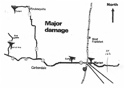
Figure 1. A general map of tornado touchdowns on May 29, 1982.
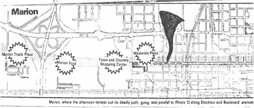
Figure 2. A map showing locations that received extensive damage
in Marion, Illinois on May 29, 1982.

