Overview
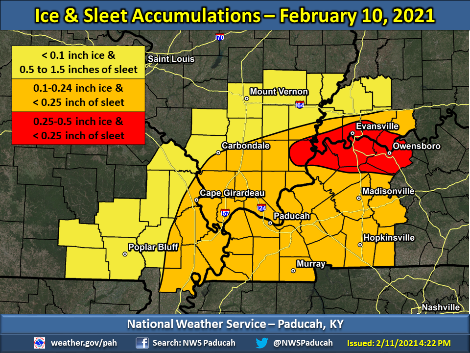
A wintry mix of precipitation impacted the region resulting in icy roads, numerous accidents, road closures, and scattered power outages. The event started in the early morning hours of February 10th and continued into the morning hours on February 11th. Ice accumulations ranged from 0.1" to 0.5" across much of the region. Sleet accumulations of 0.5" to 1.5" also occurred across northern and western portions of the area. Icy roads on the morning of February 10th resulted in two vehicle fatalities, one in Trigg County and another in Henderson County Kentucky. Numerous accidents occurred from the evening hours of the 10th into the morning of the 11th. This resulted in lengthy road closures on the Audubon Parkway west of Owensboro, sections of I-24 between Calvert City and Hopkinsville, KY, sections of I-55 between Cape Girardeau and Portageville, MO, and portions of I-57 from Sikeston, MO to Mounds, IL.Ice/Sleet Accumulations
Ice accumulations ranging from 0.1" to 0.25" were commonplace across western Kentucky, south of I-64 in southwest Indiana, along and south of Route 13 in southern Illinois, and along and east of I-55 in southeast Missouri. A narrow zone of higher ice amounts, ranging from 0.25" to 0.5", occurred from Shawneetown, IL eastward into the Evansville, Henderson, and Owensboro areas. Scattered power outages were primarily focused in this zone of higher accumulations as well. Most areas received at least minor accumulations of sleet along and north of the Ohio River, but the heaviest swath of sleet amounts ranging from 0.5" to 1.5" occurred across southeast Missouri, areas of southern Illinois north of Route 13, and portions of southwest Indiana along and north of I-64.
 |
Photos
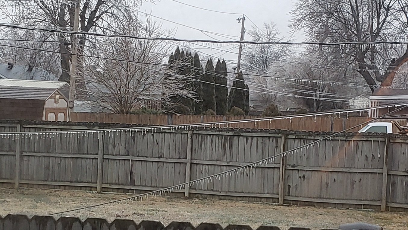
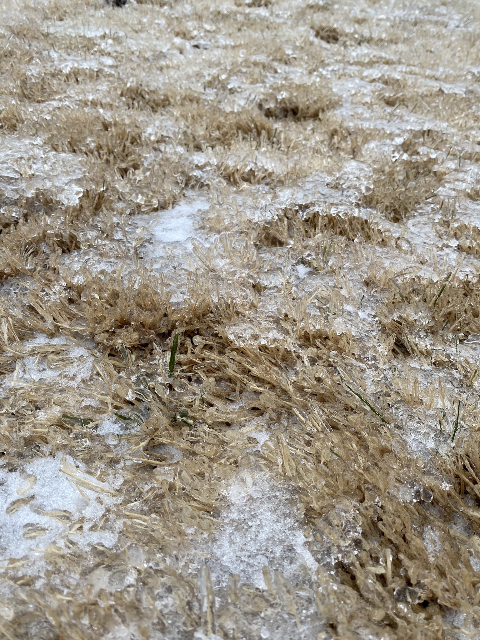
Here are some pictures submitted from around the area during and after the event:
 |
 |
 |
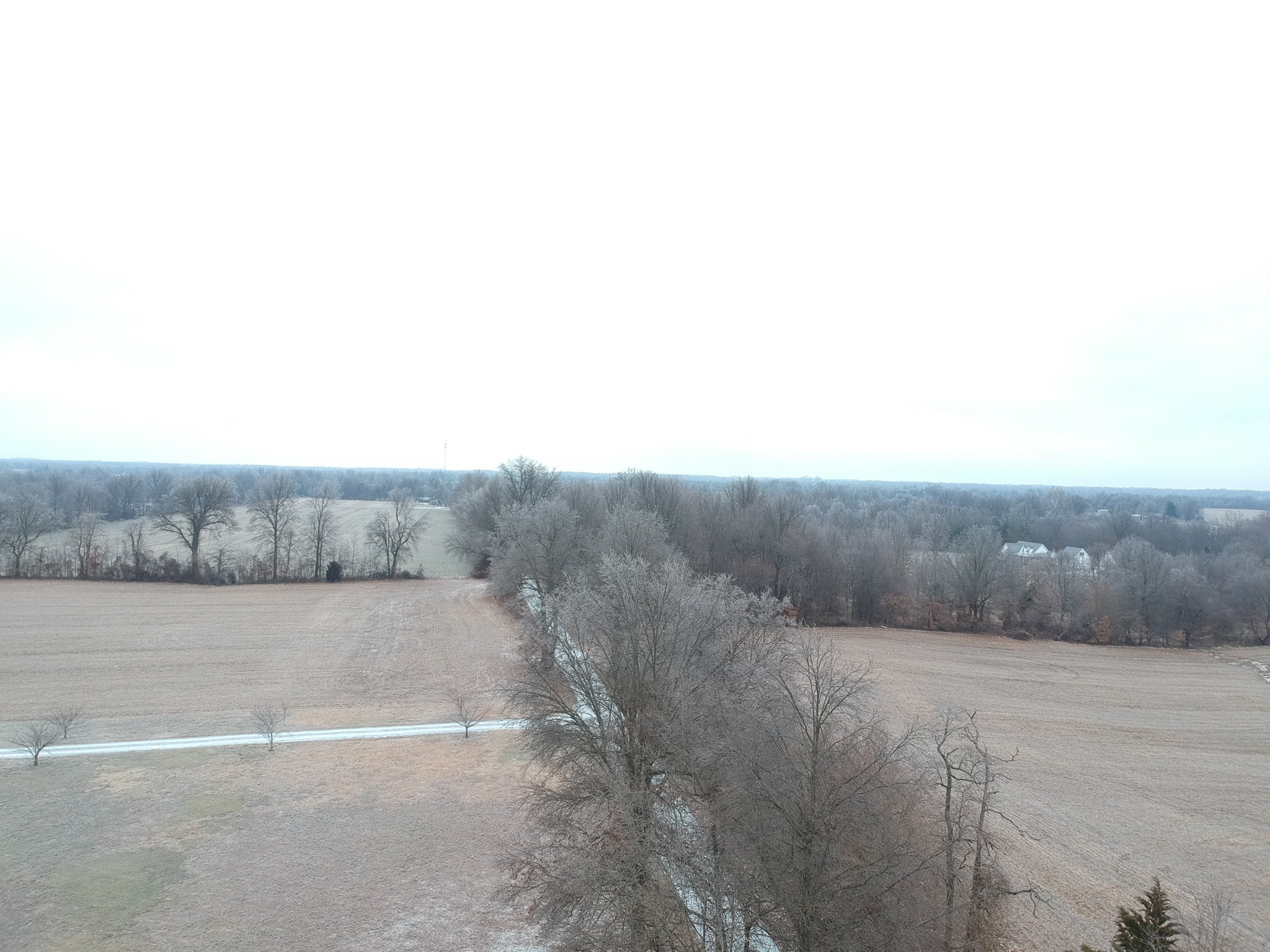 |
| Icy scene in Owensboro, KY courtesy of Chris Crabtree | Evansville, IN courtesy of Connor Davis | Malden, MO courtesy of Jeremy Stephens | Ballard County, KY courtesy of Dustin Bell |
 |
 |
 |
 |
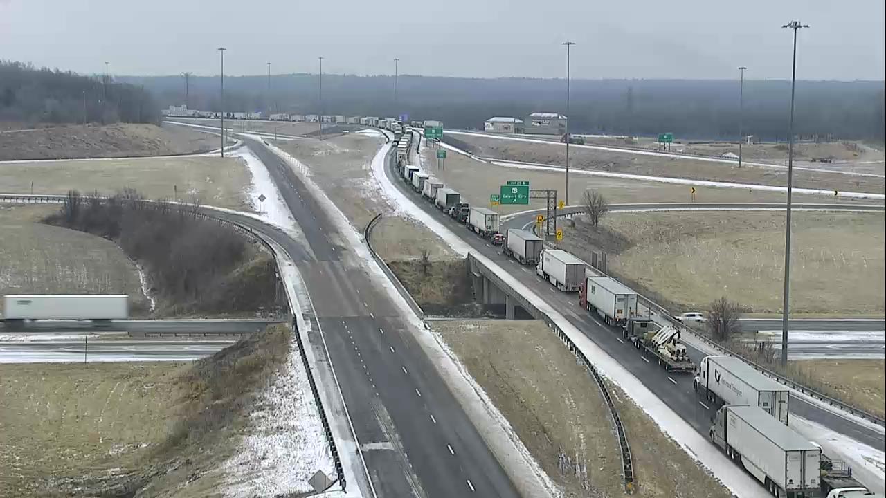
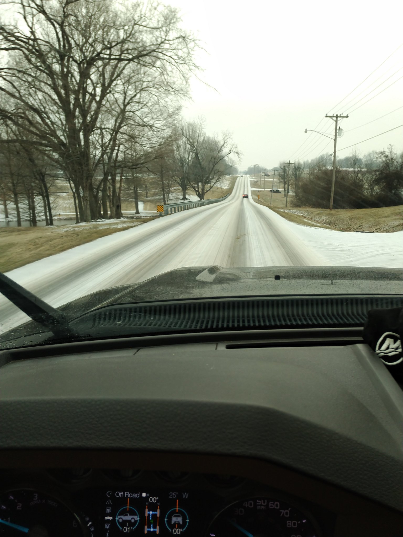
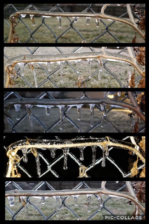
| I-24 interchange near Calvert City courtesy of KY Transportation Cabinet morning of February 11 | Sleet covered roads in Jackson, MO courtesy of Brian Blankenship | Icy fence in Owensboro, KY courtesy of Tiffany Neal Lanham | Accident on I-24 near Hopkinsville, KY courtesy of KY Transportation Cabinet morning of February 11 |
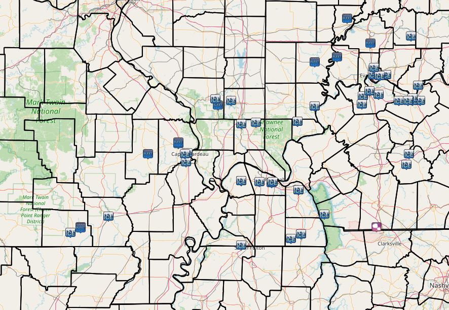
Storm Reports
Here is a static map of sleet and ice accumulation reports we received during the map. Below the map you will find the text summary of all local storm reports issued.
 |
PRELIMINARY LOCAL STORM REPORT...SUMMARY
NATIONAL WEATHER SERVICE PADUCAH KY
119 PM CST THU FEB 11 2021

..TIME...   ...EVENT...      ...CITY LOCATION...     ...LAT.LON...
..DATE...   ....MAG....      ..COUNTY LOCATION..ST.. ...SOURCE....
            ..REMARKS..

0743 AM     FREEZING RAIN    3 WSW GOLDON POND       36.78N 88.07W
02/10/2021  E0.01 INCH       TRIGG              KY   EMERGENCY MNGR

            *** 1 FATAL ***
            FREEZING DRIZZLE LED TO A FATAL ACCIDENT ON
            US 68/KY 80 AT THE WOODLAND TRACE
            INTERCHANGE. TIME ESTIMATED.

0900 AM     FREEZING RAIN    5 SW HENDERSON          37.80N 87.65W
02/10/2021  E0.01 INCH       HENDERSON          KY   BROADCAST MEDIA

            *** 1 FATAL ***
            FREEZING DRIZZLE CAUSED A FATAL THREE
            VEHICLE ACCIDENT ON US 60 IN HENDERSON
            COUNTY. TIME AND LOCATION APPROXIMATE.

1011 AM     SLEET            5 NNW OXLY              36.67N 90.71W
02/10/2021  E0.2 INCH        RIPLEY             MO   TRAINED SPOTTER

            FREEZING DRIZZLE HAS TRANSITION TO SLEET
            WITH APPROXIMATELY 0.2 INCH OF ACCUMULATION
            ON US 160. ROADS ARE EXTREMELY SLICK.

1045 AM     FREEZING RAIN    CAPE GIRARDEAU          37.31N 89.55W
02/10/2021  M0.07 INCH       CAPE GIRARDEAU     MO   BROADCAST MEDIA

            TOTAL ACCUMULATION OF SLEET AND FREEZING
            RAIN.

1049 AM     SLEET            NEW HARMONY             38.13N 87.93W
02/10/2021  U0.1 INCH        POSEY              IN   TRAINED SPOTTER

            MODERATE TO HEAVY SLEET FALLING AND COVERING
            THE GROUND.

1056 AM     FREEZING RAIN    POPLAR BLUFF            36.76N 90.41W
02/10/2021  E0.05 INCH       BUTLER             MO   BROADCAST MEDIA

            ACCUMULATION OF SLEET AND FREEZING RAIN.
            ROADS ARE VERY SLICK IN POPLAR BLUFF, WITH
            SEVERAL SLIDE OFFS REPORTED ON US 67.

1136 AM     FREEZING RAIN    5 W DUFF                38.31N 87.13W
02/10/2021  U0.01 INCH       PIKE               IN   TRAINED SPOTTER

            SPOTTER REPORTS FREEZING RAIN AND SLEET
            BEGINNING TO ACCUMULATE.

0129 PM     SLEET            MARBLE HILL             37.30N 89.98W
02/10/2021  E0.3 INCH        BOLLINGER          MO   EMERGENCY MNGR

            SLEET ACCUMULATION OF A QUARTER TO A THIRD
            OF AN INCH.

0131 PM     SLEET            FORT BRANCH             38.25N 87.57W
02/10/2021  M0.5 INCH        GIBSON             IN   TRAINED SPOTTER

            STORM TOTAL ACCUMULATION OF SNOW AND SLEET.

0203 PM     FREEZING RAIN    1 W KARBERS RIDGE       37.58N 88.36W
02/10/2021  M0.20 INCH       HARDIN             IL   TRAINED SPOTTER

            CORRECTS TIME FROM PREVIOUS FREEZING RAIN
            REPORT FROM 1 W KARBERS RIDGE. GLAZING ON
            TREES AND SECONDARY ROADS.

0309 PM     FREEZING RAIN    CARTERVILLE             37.76N 89.08W
02/10/2021  M0.10 INCH       WILLIAMSON         IL   BROADCAST MEDIA

            PRECIPITATION HAS TRANSITION FROM SLEET TO
            FREEZING RAIN. GLAZING ON NORTH SIDE OF
            TREES. MEASURED AT WSIL-TV.

0312 PM     FREEZING RAIN    6 ESE HENDERSON         37.81N 87.48W
02/10/2021  M0.13 INCH       HENDERSON          KY   TRAINED SPOTTER

            RELAYED VIA TWITTER.

0430 PM     FREEZING RAIN    12 NNE VIENNA           37.57N 88.81W
02/10/2021  M0.12 INCH       JOHNSON            IL   PUBLIC


0530 PM     ICE STORM        5 S STANLEY             37.76N 87.26W
02/10/2021                   DAVIESS            KY   FIRE DEPT/RESCUE

            2 POLES SNAPPED WITH MULTIPLE WIRES COVERING
            BOTH WEST/EAST BOUND LANES OF THE AUBUBON
            PARKWAY WEST OF OWENSBORO. STATE TROOPERS
            HAVE CLOSED THE PARKWAY IN BOTH DIRECTIONS.

0625 PM     FREEZING RAIN    DONIPHAN                36.62N 90.82W
02/10/2021  E0.25 INCH       RIPLEY             MO   PUBLIC

            1/4 INCH OF SLEET/ICE COMBINATION.

0630 PM     FREEZING RAIN    SHAWNEETOWN             37.71N 88.17W
02/10/2021  M0.50 INCH       GALLATIN           IL   TRAINED SPOTTER

            APPROXIMATELY 1/2 INCH OF ICE MEASURED IN
            SHAWNEETOWN.

0636 PM     ICE STORM        3 NW PHILPOT            37.76N 87.03W
02/10/2021                   DAVIESS            KY   FIRE DEPT/RESCUE

            TREE DOWN ON THRUSTON-DERMONT ROAD EAST OF
            OWENSBORO.

0700 PM     FREEZING RAIN    2 SSE HEATH             37.06N 88.77W
02/10/2021  M0.19 INCH       MCCRACKEN          KY   ASOS

            ICE ACCUMULATION AT THE PADUCAH, KY ASOS
            STATION SINCE MIDNIGHT.

0700 PM     FREEZING RAIN    2 W SCOTT CITY          37.23N 89.57W
02/10/2021  M0.12 INCH       SCOTT              MO   ASOS

            ICE ACCUMULATION AT THE CAPE GIRARDEAU ASOS
            SINCE MIDNIGHT.

0700 PM     FREEZING RAIN    2 NW MELODY HILL        38.04N 87.53W
02/10/2021  M0.27 INCH       VANDERBURGH        IN   ASOS

            ICE ACCUMULATION MEASURED BY EVANSVILLE
            AIRPORT ASOS SINCE MIDNIGHT.

0700 PM     FREEZING RAIN    4 NW CARBONDALE         37.77N 89.25W
02/10/2021  M0.16 INCH       JACKSON            IL   ASOS

            ICE ACCUMULATION AT THE CARBONDALE AIRPORT
            ASOS SINCE MIDNIGHT.

0715 PM     ICE STORM        OWENSBORO               37.76N 87.11W
02/10/2021                   DAVIESS            KY   TRAINED SPOTTER

            MULTIPLE REPORTS OF TREES DOWN AND POWER
            POLES ON FIRE IN OWENSBORO AND AROUND THE
            COUNTY DUE TO ICING.

0730 PM     FREEZING RAIN    2.6 N NEWBURGH          37.98N 87.40W
02/10/2021  M0.25 INCH       WARRICK            IN   PUBLIC

            TOTAL ICE ACCRETION SO FAR, RELAYED VIA
            TWITTER.

0740 PM     ICE STORM        ROCKPORT                37.89N 87.05W
02/10/2021                   SPENCER            IN   EMERGENCY MNGR

            MULTIPLE REPORTS OF TREES DOWN THROUGHOUT
            SPENCER COUNTY DUE TO ICING.

0900 PM     FREEZING RAIN    2 NE LONE OAK           37.05N 88.64W
02/10/2021  M0.21 INCH       MCCRACKEN          KY   BROADCAST MEDIA

            MEASURED AT WPSD-TV STATION IN PADUCAH.
            LARGE SLEET PELLETS FALLING AT TIME OF
            OBSERVATION.

0930 PM     FREEZING RAIN    GOREVILLE               37.56N 88.97W
02/10/2021  M0.25 INCH       JOHNSON            IL   BROADCAST MEDIA

            A QUARTER INCH OF SLEET ON TOP OF THE ICE.

0930 PM     FREEZING RAIN    2 WSW CAPE GIRARDEAU    37.30N 89.58W
02/10/2021  M0.12 INCH       CAPE GIRARDEAU     MO   BROADCAST MEDIA

            MEASURED 1/8 INCH OF ICE WITH A HALF INCH OF
            SLEET ON TOP OF IT. WEST SIDE OF CAPE
            GIRARDEAU.

1030 PM     FREEZING RAIN    HENDERSON               37.84N 87.58W
02/10/2021  M0.40 INCH       HENDERSON          KY   TRAINED SPOTTER

            MEASURED ABOUT 3/8 INCH OF ICE ACCUMULATION
            ON NORTH SIDE OF HENDERSON.

0638 AM     ICE STORM        MURRAY                  36.61N 88.32W
02/11/2021                   CALLOWAY           KY   CO-OP OBSERVER

            0.20" LAST 24 HOURS, 0.25" STORM TOTAL ICE.

0723 AM     HAIL             2 WNW FORT CAMPBELL NOR 36.67N 87.50W
02/11/2021  M0.50 INCH       CHRISTIAN          KY   OTHER FEDERAL

            HALF INCH HAIL REPORTED BY THE STAFF AT FORT
            CAMPBELL.

0725 AM     FREEZING RAIN    2 E EVANSVILLE          37.98N 87.50W
02/11/2021  M0.30 INCH       VANDERBURGH        IN   PUBLIC

            AVERAGE OF MEASUREMENTS ON THE EAST SIDE OF
            EVANSVILLE.

0745 AM     FREEZING RAIN    GREENVILLE              37.21N 87.18W
02/11/2021  M0.25 INCH       MUHLENBERG         KY   TRAINED SPOTTER

            AVERAGE ICE THICKNESS. RELAYED VIA TWITTER.

0745 AM     FREEZING RAIN    3 S CALVERT CITY        36.99N 88.35W
02/11/2021  M0.25 INCH       MARSHALL           KY   NWS EMPLOYEE

            EVENT TOTAL FREEZING RAIN ACCUMULATION.

0745 AM     FREEZING RAIN    1 WNW CENTRAL CITY      37.30N 87.15W
02/11/2021  M0.25 INCH       MUHLENBERG         KY   TRAINED SPOTTER

            RELAYED VIA TWITTER.

0750 AM     SLEET            1 N JACKSON             37.40N 89.65W
02/11/2021  M1.0 INCH        CAPE GIRARDEAU     MO   TRAINED SPOTTER

            STORM TOTAL SLEET AND FREEZING RAIN
            ACCUMULATION.

0750 AM     FREEZING RAIN    HARRIS GROVE            36.57N 88.43W
02/11/2021  M0.22 INCH       CALLOWAY           KY   PUBLIC

            FREEZING RAIN HAS TRANSITIONED TO SLEET.

0815 AM     FREEZING RAIN    1 S PADUCAH             37.06N 88.63W
02/11/2021  M0.19 INCH       MCCRACKEN          KY   NWS EMPLOYEE

            STORM TOTAL FREEZING RAIN AND SNOW
            ACCUMULATION.

0845 AM     FREEZING RAIN    LA CENTER               37.07N 88.97W
02/11/2021  M0.25 INCH       BALLARD            KY   TRAINED SPOTTER

            STORM TOTAL ICE ACCUMULATION. RELAYED VIA
            TWITTER.

0933 AM     SLEET            4 NW MOUNT CARMEL       38.46N 87.82W
02/11/2021  M0.5 INCH        WABASH             IL   TRAINED SPOTTER

            STORM TOTAL SLEET AND SNOW ACCUMULATION.

0945 AM     SLEET            5 N OXLY                36.66N 90.71W
02/11/2021  E0.3 INCH        RIPLEY             MO   TRAINED SPOTTER

            TOTAL SLEET/SNOW/FREEZING RAIN ACCUMULATION.

1013 AM     FREEZING RAIN    3 ESE CORYDON           37.73N 87.66W
02/11/2021  M0.30 INCH       HENDERSON          KY   TRAINED SPOTTER

            MEASURED NEAR CAIRO, KY. RELAYED VIA
            TWITTER.

1019 AM     FREEZING RAIN    OWENSBORO               37.78N 87.11W
02/11/2021  M0.25 INCH       DAVIESS            KY   PUBLIC

            MINOR TREE LIMB DAMAGE REPORTED IN
            OWENSBORO.

1030 AM     FREEZING RAIN    2 W OWENSBORO           37.76N 87.16W
02/11/2021  M0.38 INCH       DAVIESS            KY   PUBLIC

            MEASURED ON THE WEST SIDE OF OWENSBORO.
            RELAYED VIA FACEBOOK.

1037 AM     ICE STORM        4 WNW NEWBURGH          37.97N 87.47W
02/11/2021                   VANDERBURGH        IN   TRAINED SPOTTER

            ONE LARGE TREE DOWN AS WELL AS SEVERAL
            DOWNED SMALL TREE BRANCHES NEAR PLAZA IPS.
            MEASURED 0.25 OF ICE ACCUMULATION. RELAYED
            VIA TWITTER.

1050 AM     FREEZING RAIN    MURRAY                  36.61N 88.32W
02/11/2021  M0.25 INCH       CALLOWAY           KY   TRAINED SPOTTER

            0.25" OF ICE AND 0.1" OF SLEET. MEASURED IN
            DOWNTOWN MURRAY.

1200 PM     SLEET            CARMI                   38.09N 88.17W
02/11/2021  M1.0 INCH        WHITE              IL   TRAINED SPOTTER

            1.0 OF SLEET, SNOW, AND FREEZING RAIN
            ACCUMULATION. 0.35 LIQUID EQUIVALENT.

1200 PM     FREEZING RAIN    5 W FULTON              36.51N 88.97W
02/11/2021  M0.20 INCH       FULTON             KY   TRAINED SPOTTER

            0.20" OF FREEZING RAIN MEASURED ON BRANCHES,
            0.35" MELTED LIQUID OF SNOW, SLEET, AND
            FREEZING RAIN.
 |
Media use of NWS Web News Stories is encouraged! Please acknowledge the NWS as the source of any news information accessed from this site. |
|

