Overview
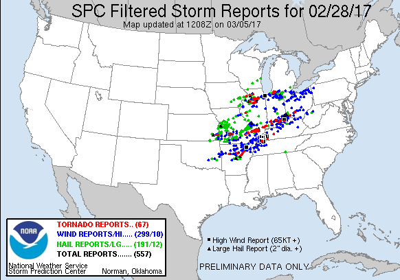
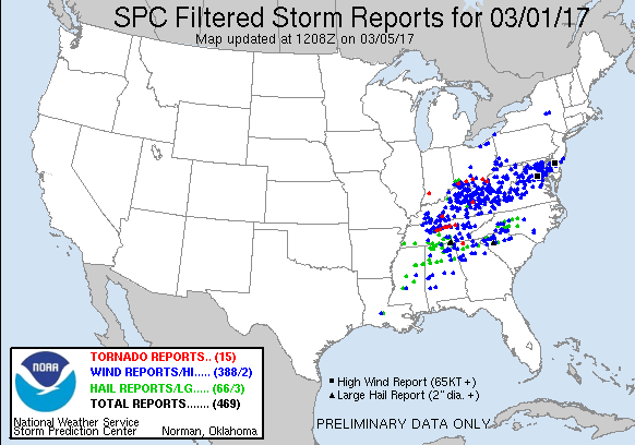
A significant severe weather event occurred in our forecast area from the evening of February 28th into the early morning hours of March 1st. Two waves of severe storms occurred with the first consisting of multiple supercells during the evening hours, one of which produced 2 long track tornadoes. The second round was an intense squall line that moved into southeast Missouri and southern Illinois after 3 AM and was out of the area by 7 AM. Damaging winds in excess of 80 mph were reported with this line as it moved across western Kentucky. There were 8 confirmed tornadoes from this event, with 1 EF-4 (Perryville, MO), 1 EF-3 (Crossville, IL), and 1 EF-2 (Cuba, KY).
Summaries from SPC and other NWS Offices
Tornadoes:
Click here for Public Information Statements for all the tornadoes
|
|
||||||||||
|
||||||||||
|
Tornado #1 - Perryville, MO
Track Map 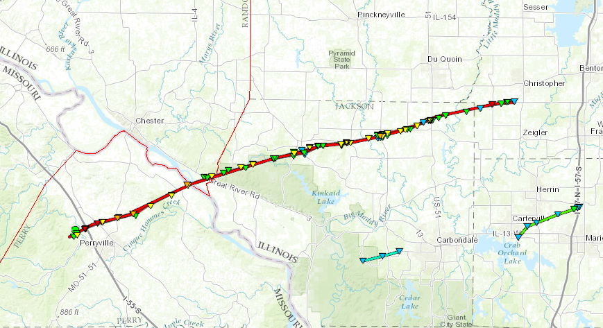 
|
||||||||||||||||
|
Tornado #2 - Crossville, IL
Track Map 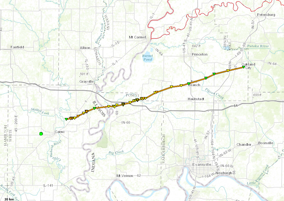
|
||||||||||||||||
|
Tornado #3 - Williamson County Illinois
Track Map 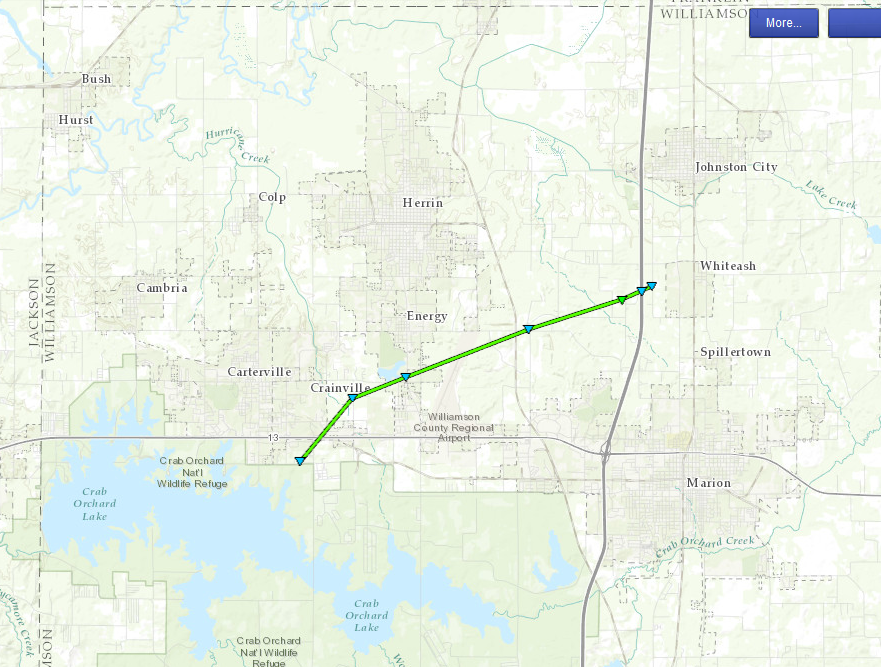
|
||||||||||||||||
|
Tornado #4 - Jackson County Illinois
Track Map 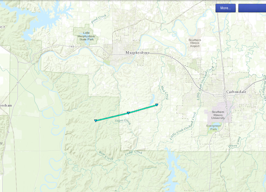
|
||||||||||||||||
|
Tornado #5 - Trigg County Kentucky
Track Map 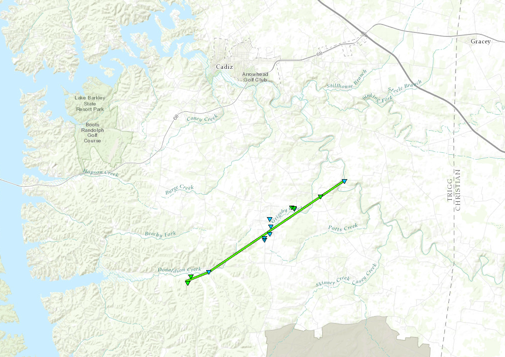
|
||||||||||||||||
|
Tornado #6 - Cuba, Kentucky
Track Map 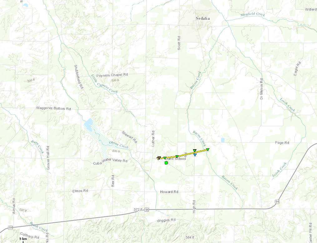
|
||||||||||||||||
|
Tornado #7 - Mississippi & New Madrid Counties Missouri
Track Map 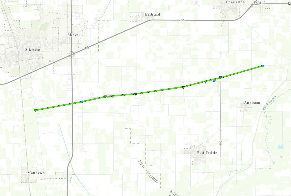
|
||||||||||||||||
|
Tornado #8 - Lynn Grove, KY
Track Map 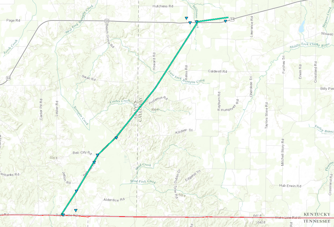
|
||||||||||||||||
The Enhanced Fujita (EF) Scale classifies tornadoes into the following categories:
| EF0 Weak 65-85 mph |
EF1 Moderate 86-110 mph |
EF2 Significant 111-135 mph |
EF3 Severe 136-165 mph |
EF4 Extreme 166-200 mph |
EF5 Catastrophic 200+ mph |
 |
|||||
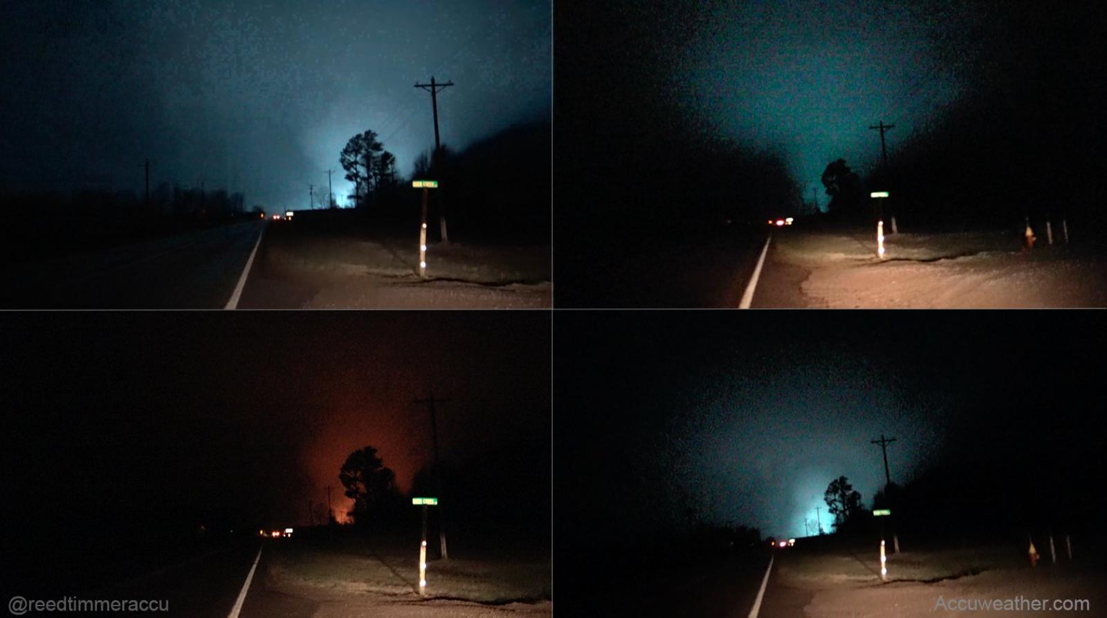
Photos: (Click images to enlarge them)
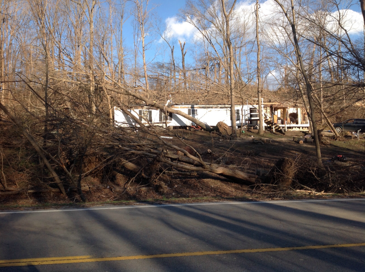
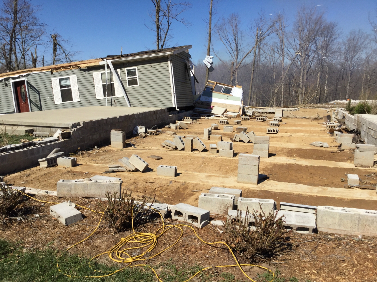
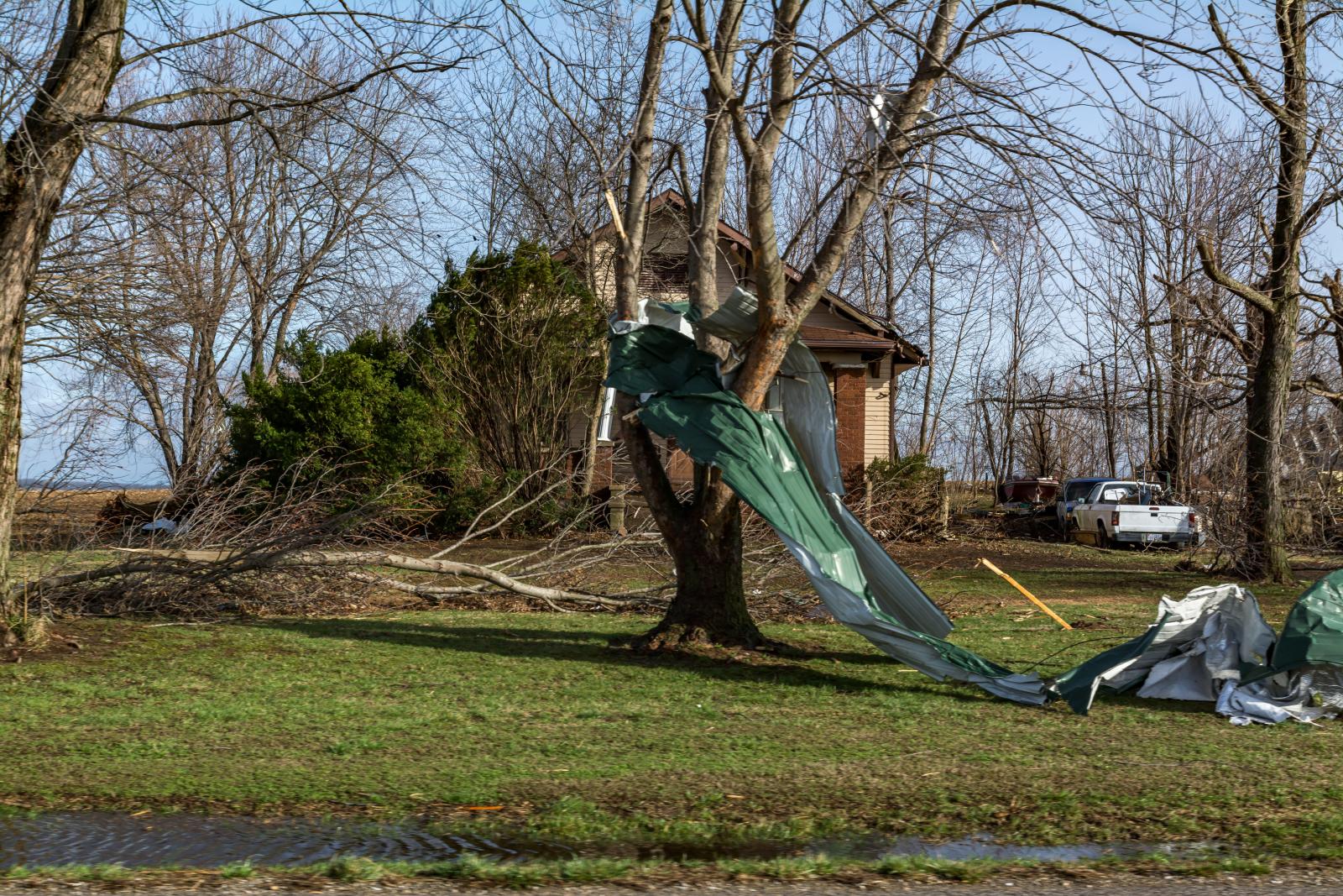
Perryville, MO Tornado: (Perry County Missouri, Jackson and Franklin Counties Illinois)
 |
 |
 |
 |
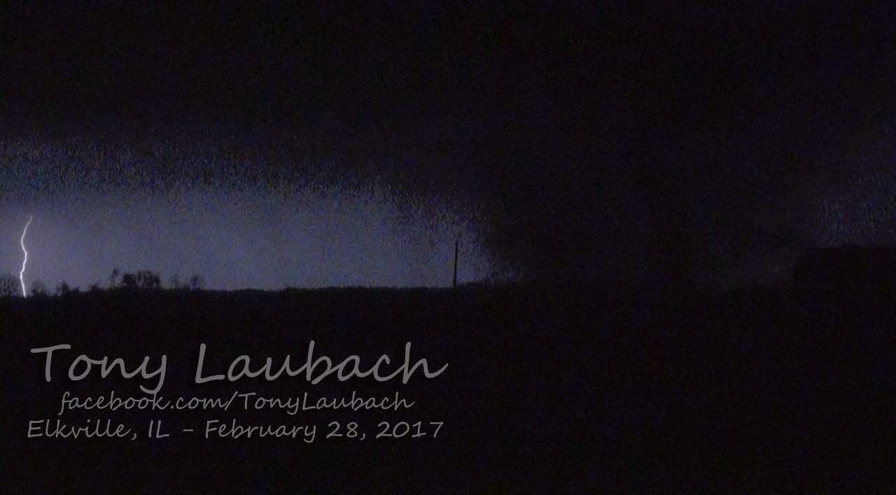
| Tornado pictures southeast of Rockport, IL via Reed Timmer | Tornado near Elkville, IL - Tony Laubach |
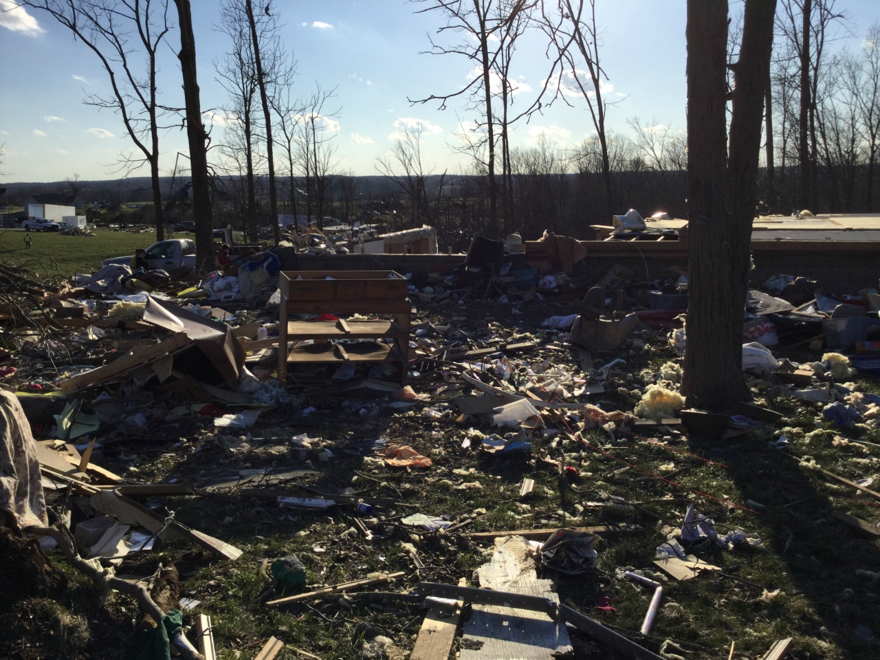
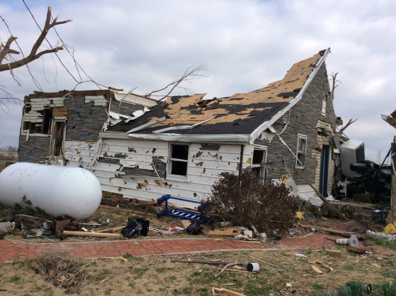
Damage near County Rd 806 northwest of Perryville, MO - NWS Storm Survey |
Damage near Moore Drive northwest of Perryville, MO - NWS Storm Survey |
 |
 |
 |
 |
| Damage near Moore Drive northwest of Perryville, MO - NWS Storm Survey |
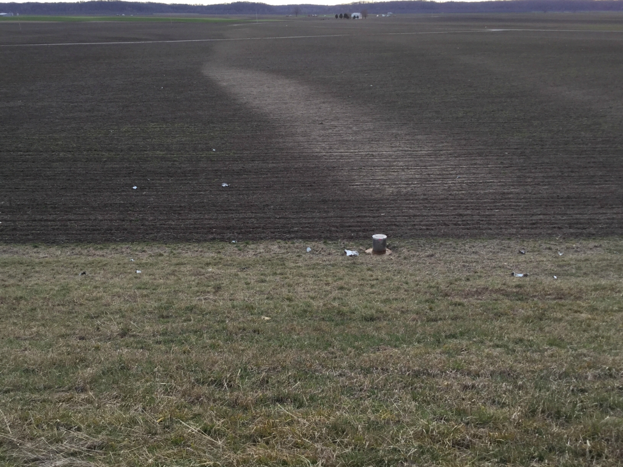
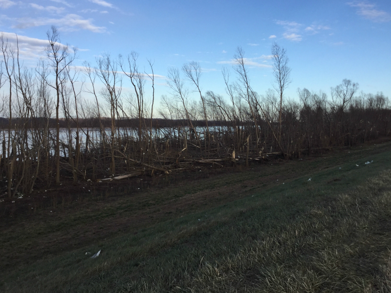
Ground scarring/striations near Mississippi River in Perry County MO - NWS Storm Survey | Tree damage along Mississippi River in Perry County MO - NWS Storm Survey |
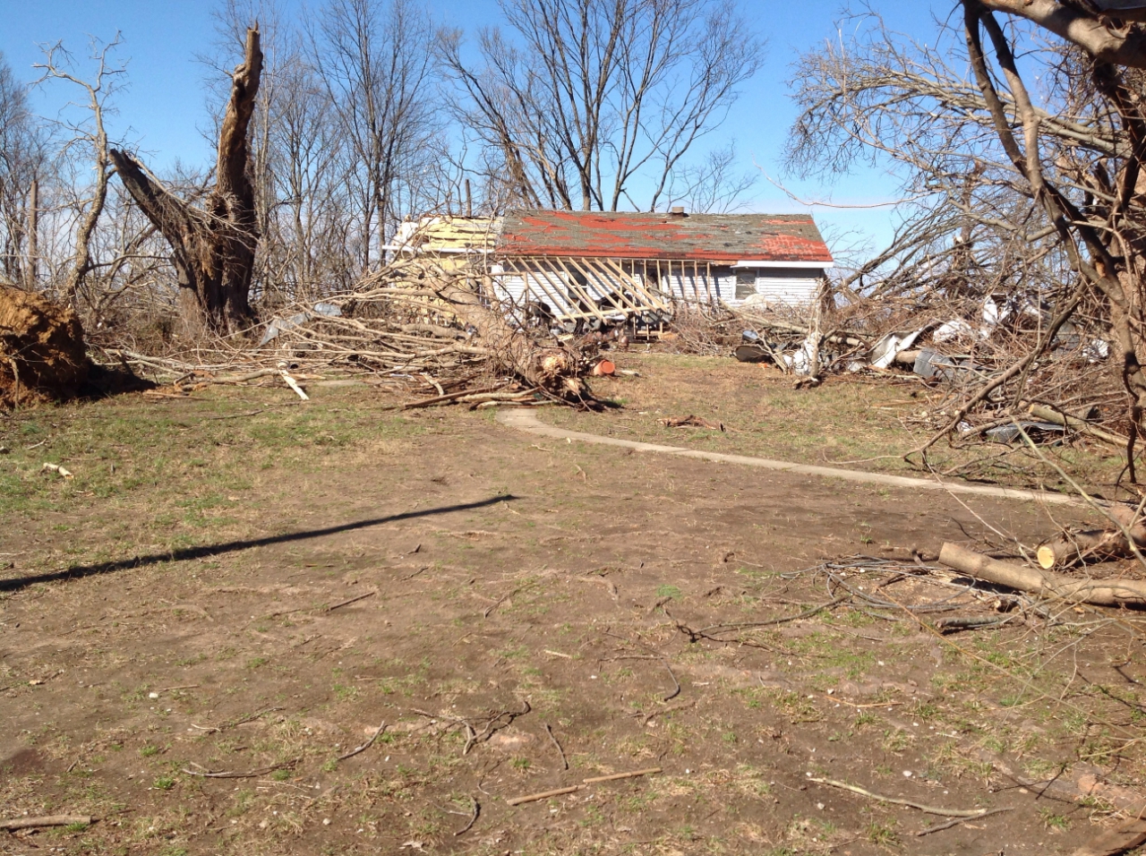
Damage south of Ava, IL - NWS Storm Survey |
 |
 |
 |
 |
| Damage on Marlboro Rd east of Ava, IL - NWS Storm Survey | Damage south of Vergennes, IL - NWS Storm Survey |
Damage north of Elkville, IL - NWS Storm Survey |
Damage south of Mulkeytown, IL - NWS Storm Survey |
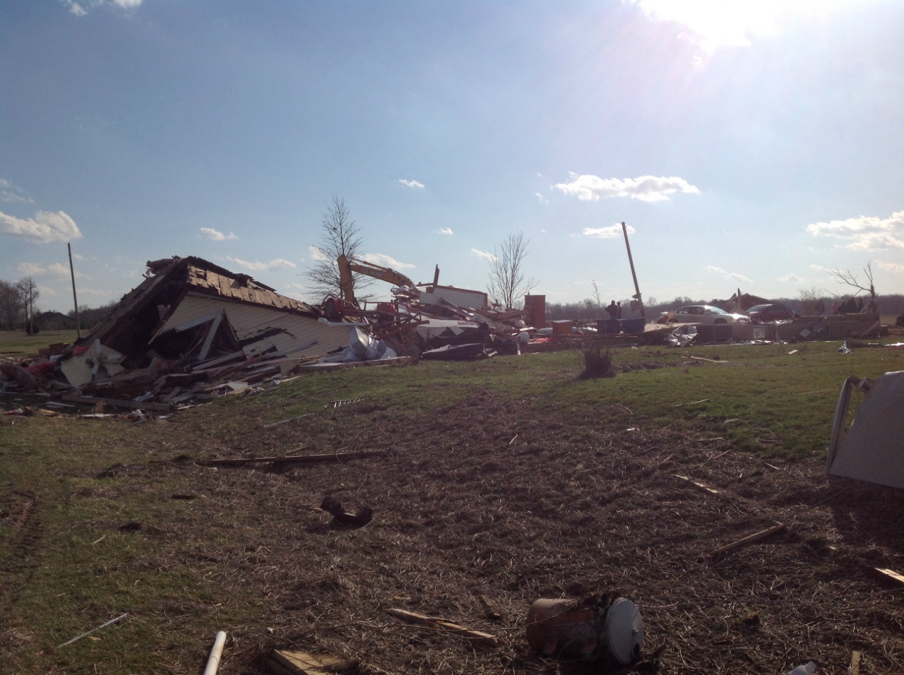
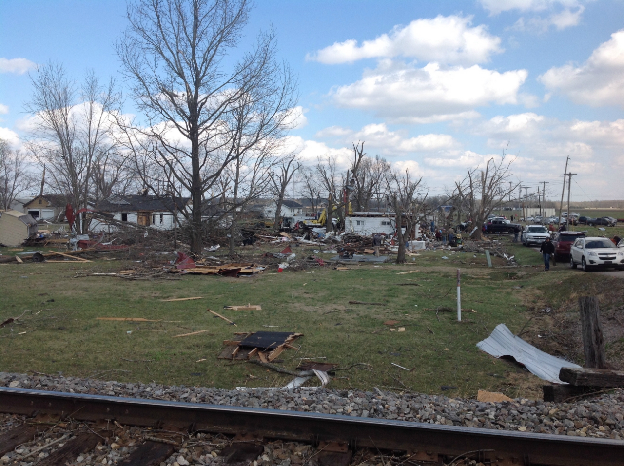
Crossville, IL Tornado: (White County Illinois, Posey and Gibson Counties Indiana)
 |
 |
%20-%20NWS%20Survey.jpg) |
 |
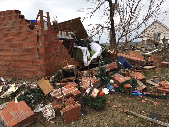
| Damage southwest of Crossville, IL - NWS Storm Survey | Damage south of Crossville, IL - NWS Storm Survey | House damaged 2 miles E of Crossville, IL. This house was also hit by 1925 Tri-State Tornado. | Damage south of Griffin, IN - NWS Storm Survey |
 |
 |
 |
 |
| Damage near Poseyville, IN - NWS Storm Survey |
Damage near Fort Branch, IN - Scott Walden |
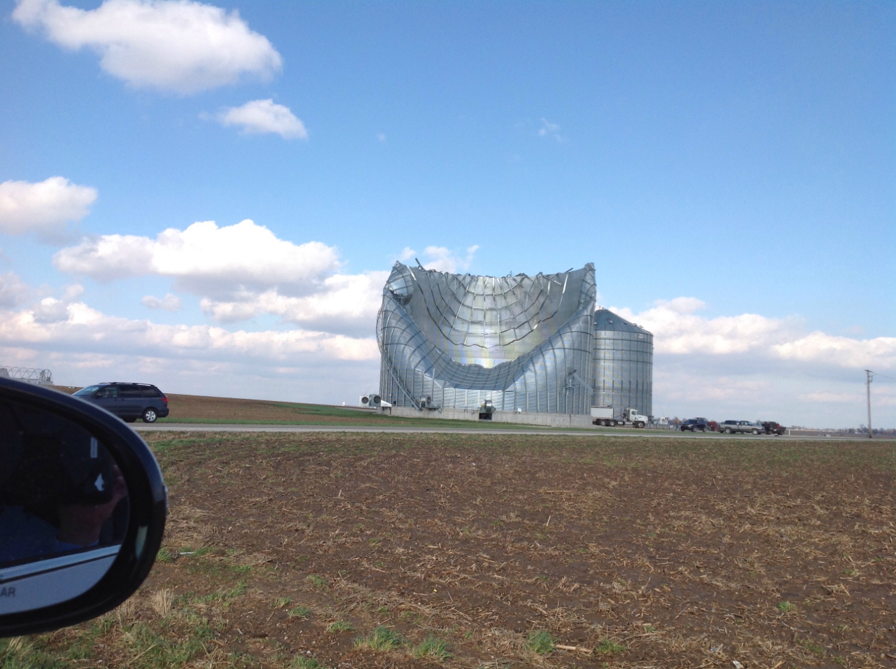
Grain Bin damaged near Fort Branch, IN - NWS Storm Survey | Tornado north of Poseyville - Jason Gerteisen |
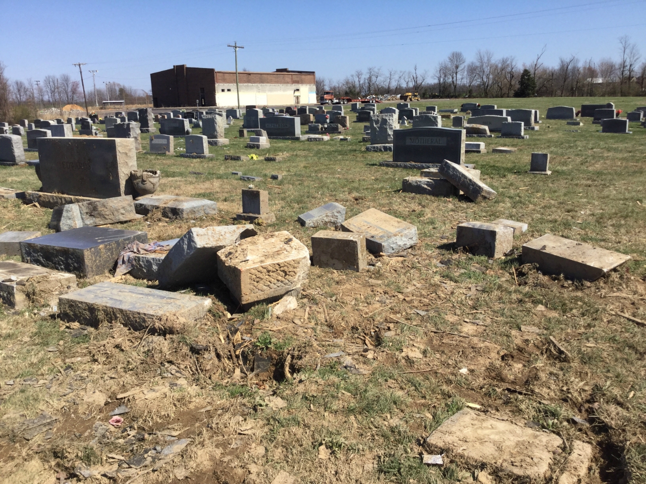
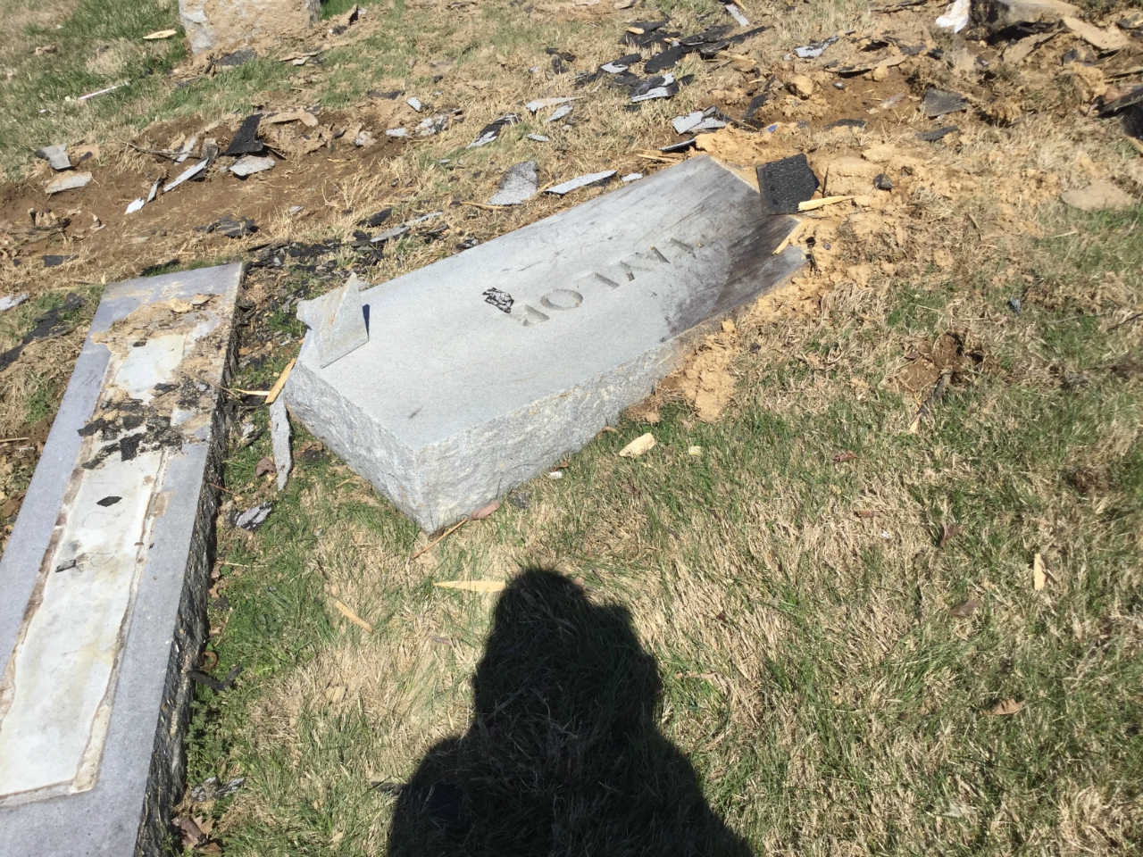
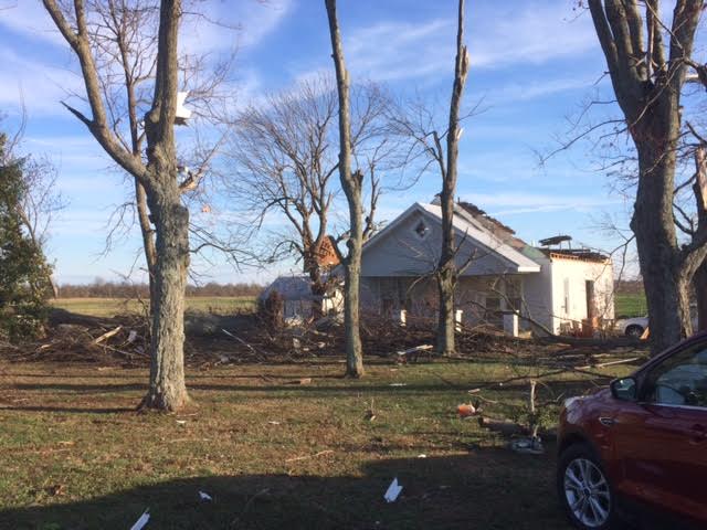
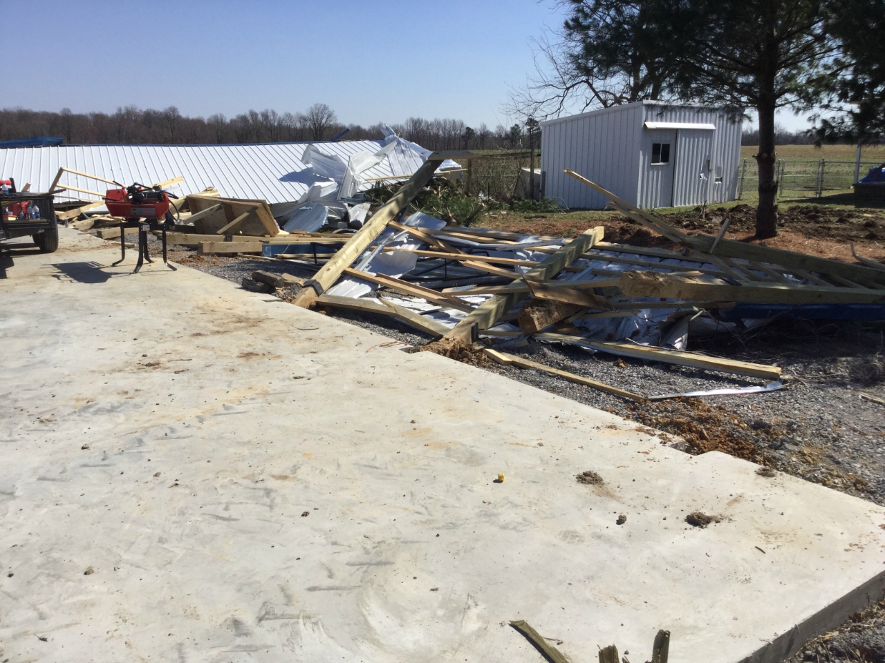
Cuba, KY Tornado: (Graves County)
 |
 |
 |
 |
| Numerous headstones blown around 30 feet in Cuba cemetery - NWS Storm Survey |
Headstone shoved into ground in cemetery - NWS Storm Survey | Large sections of roof heavily damaged to house in Cuba - NWS Storm Survey |
Machine shed damaged east of Cuba - NWS Storm Survey |
Radar: (Click images to enlarge them)
Click here for a radar loop of this event
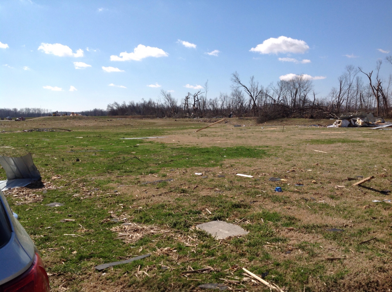
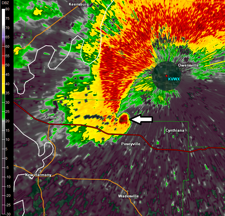
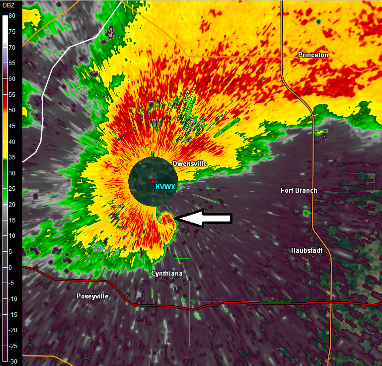
Multiple supercells moved east/northeast across the area during the evening hours of the 28th. One supercell in particular was quite strong producing multiple long track tornadoes. The first tornado began northwest of Perryville, MO and was on the ground for just over 1 hour, traveling 50 miles into Jackson and western Franklin counties in Illinois. After merging with a storm coming out of Williamson County, the supercell storm took some time regaining its strength. It eventually produced another tornado in White County Illinois near Crossville, that moved into Gibson and Posey Counties Indiana before dissipating some 50 minutes later near Oakland City, IN. This tornado path was around 44 miles long. This supercell storm entered our forecast area in western Perry County Missouri about 7:45 PM. It then proceeded east northeast, before exiting our forecast area in Pike County Indiana about 11:15 PM.
The line of storms that raced through the area during the early morning hours produced widespread damaging winds, in particular across western KY. A brief tornado developed along this line affecting the Cuba, KY area shortly after 5 AM. This line of storms entered our far northwest counties, Jefferson and Perry Illinois, about 3:15 AM and exited our forecast area in western Kentucky around 6:45 AM.
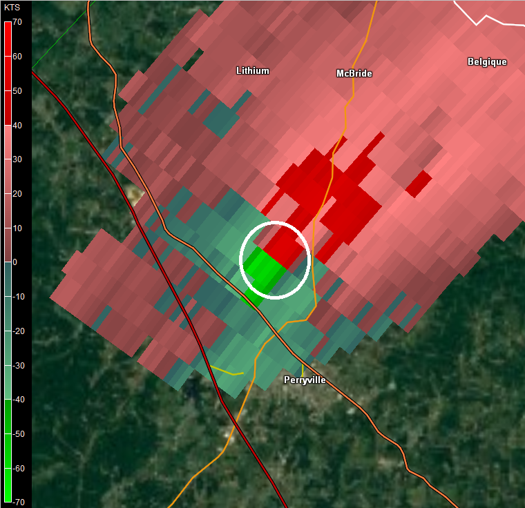
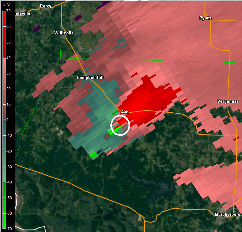
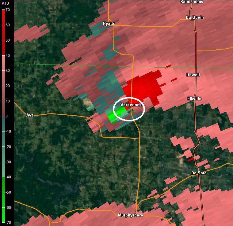
Perryville, MO to Christopher, IL tornadic supercell:
 |
 |
 |
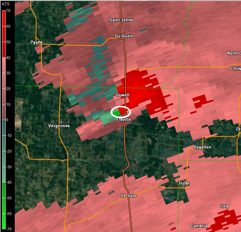 |
| SRM near Perryville, MO at 8:02 PM | SRM near Ava, IL at 8:28 PM | SRM near Vergennes, IL at 8:38 PM | SRM near Elkville, IL at 8:45 PM |
Rotational Velocities were generally 50-75 knots most of the time from northwest of Perryville, MO until the storm passed just north of Elkville, IL.
This indicates very strong rotation for most of the life span of this tornado.
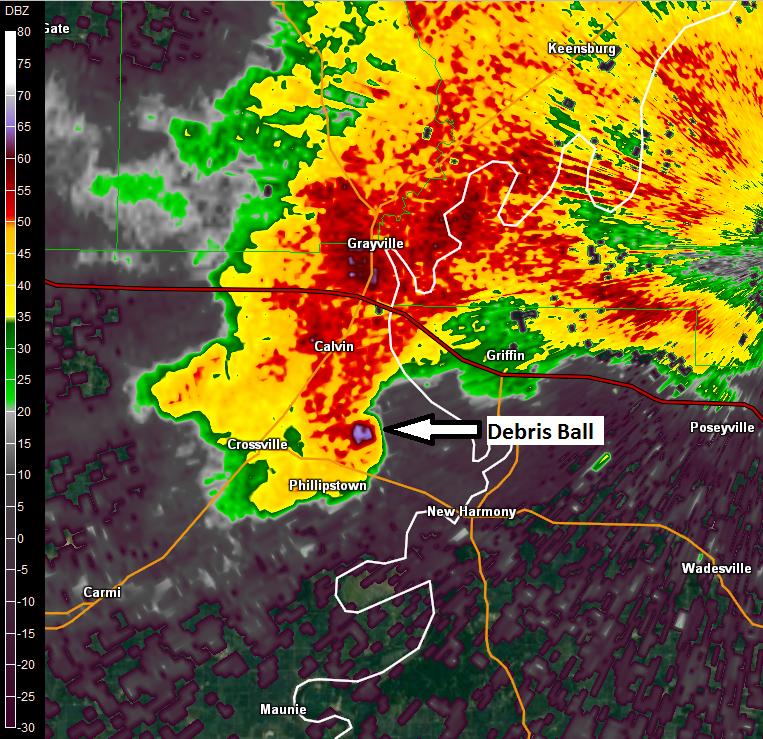
Crossville, IL to Oakland City, IN tornadic supercell:
 |
 |
 |
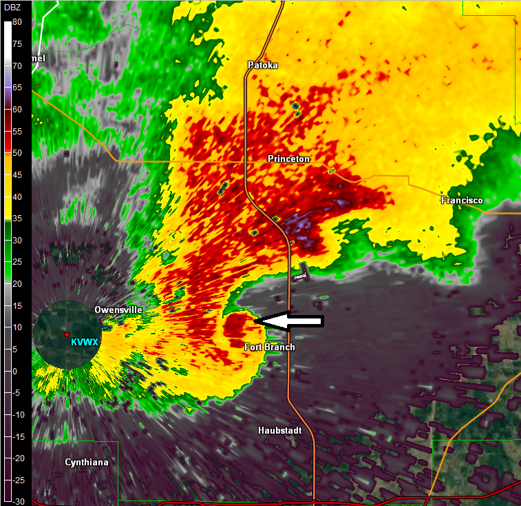 |
| Reflectivity showing Debris Ball just east of Crossville, IL at 10:05 PM | Radar at 10:17 PM north of Poseyville, IN after tornado crossed I-64 | Radar at 10:22 PM showing how close the tornado came to Evansville Radar (within 2 miles) | Radar at 10:29 PM shows tornado moving just north of Fort Branch, IN |
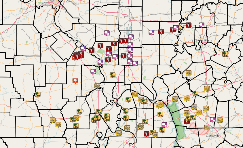
Storm Reports (Click images to enlarge them)
|
|
|
|
..TIME...   ...EVENT...      ...CITY LOCATION...     ...LAT.LON...
..DATE...   ....MAG....      ..COUNTY LOCATION..ST.. ...SOURCE....
            ..REMARKS..

0751 PM     FUNNEL CLOUD     2 N SILVER LAKE         37.71N 89.99W
02/28/2017                   PERRY              MO   TRAINED SPOTTER

            TREES SNAPPED OR UPROOTED. SOME TREES LARGE.

0755 PM     TORNADO          5 WNW PERRYVILLE        37.75N 89.96W
02/28/2017                   PERRY              MO   NWS STORM SURVEY

            *** 1 FATAL, 12 INJ *** EF-4 TORNADO WITH A 50.4 MILE
            PATH THAT ENDED 1.8 MILES SW OF CHRISTOPHER, IL. PEAK
            WINDS WERE 185 MPH. SOME OF THE WORST DAMAGE WAS ON
            NORTHWEST SIDE OF PERRYVILLE WITH 5 HOUSES LEVELED. PEAK
            WIDTH WAS 0.6 MILES. DAMAGE PATH SHOWED MULTIPLE VORTEX
            CHARACTERISTICS WITH GROUND STRIATIONS/SCARRING TO BARE
            GROUND IN PERRY COUNTY NEAR MISSISSIPPI RIVER. TORNADO
            WAS ON GROUND FOR 1 HOUR AND 2 MINUTES LIFTING AT 857PM.

0800 PM     TORNADO          4 NE SILVER LAKE        37.72N 89.94W
02/28/2017                   PERRY              MO   TRAINED SPOTTER

            LARGE TORNADO VIEWED BY TRAINED SPOTTER WITHIN POWER
            FLASHES AND LIGHTNING. TREES DAMAGED. SEVERAL HOMES
            COMPLETELY DESTROYED.

0801 PM     TSTM WND DMG     2 N PERRYVILLE          37.76N 89.87W
02/28/2017                   PERRY              MO   BROADCAST MEDIA

            POWER FLASHED VIEWED JUST NORTH OF PERRYVILLE ALONG
            INTERSTATE 55

0807 PM     TORNADO          1 N PERRYVILLE          37.74N 89.87W
02/28/2017                   PERRY              MO   TRAINED SPOTTER

            ROOF AND STRUCTURE DAMAGE REPORTED ON FAR NORTH SIDE OF
            COMMUNITY. SIGNIFICANT DAMAGE TO HOMES. MULTIPLE
            STRUCTURES DAMAGED.

0811 PM     TORNADO          3 N PERRYVILLE          37.77N 89.87W
02/28/2017                   PERRY              MO   EMERGENCY MNGR

            EMERGENCY MANAGER REPORTED OVERTURNED VEHICLES ALONG
            INTERSTATE 55 NEAR MILE MARKER 133. CONSIDERABLE DAMAGE
            REPORTED IN THE AREA. DEATHS ARE REPORTED.

0819 PM     TORNADO          2 SE ROCKWOOD           37.82N 89.67W
02/28/2017                   JACKSON            IL   TRAINED SPOTTER

            TORNADO ON THE GROUND. POWER FLASHES.

0830 PM     TORNADO          AVA                     37.89N 89.50W
02/28/2017                   JACKSON            IL   LAW ENFORCEMENT

            TORNADO ON THE GROUND. REPORTED BY OFF-DUTY STATE
            TROOPER. WIDESPREAD HOME AND TREE DAMAGE THROUGHOUT THE
            COMMUNITY.

0838 PM     TSTM WND DMG     PIEDMONT                37.15N 90.70W
02/28/2017                   WAYNE              MO   EMERGENCY MNGR

            DAMAGE TO BUILDINGS AT A LUMBER YARD IN PIEDMONT.
            NUMEROUS TREES AND POWER LINES DOWN ACROSS THE WEST PART
            OF THE COUNTY, SCATTERED POWER OUTAGES.

0842 PM     TORNADO          4 S VERGENNES           37.84N 89.34W
02/28/2017                   JACKSON            IL   TRAINED SPOTTER

            LAREGE TORNADO ON THE GROUND CROSSING STATE ROUTE 4.
            WIDESPREAD HOME AND TREE DAMAGE REPORTED BY LAW
            ENFORCEMENT.

0845 PM     TORNADO          1 N ELKVILLE            37.92N 89.24W
02/28/2017                   JACKSON            IL   EMERGENCY MNGR

            HOMES DESTROYED NORTH OF ELKVILLE. U.S. 51 NORTH OF TOWN
            IMPASSIBLE.

0854 PM     TORNADO          2 E MULKEYTOWN          37.97N 89.07W
02/28/2017                   FRANKLIN           IL   TRAINED SPOTTER

            POSSIBLE TORNADO DAMAGE. WIDESPREAD TREES AND POWER POLES
            SNAPPED THROUGHOUT THE AREA. HOME DESTROYED IN THE
            COMMUNITY ITSELF. LATE REPORT

0855 PM     TORNADO          3 WSW CHRISTOPHER       37.96N 89.10W
02/28/2017                   FRANKLIN           IL   EMERGENCY MNGR

            TORNADO ON THE GROUND. WIDESPREAD STRUCTURE DAMAGE
            REPORTED ALONG YELLOW BANKS ROAD.

0906 PM     TORNADO          2 E CHRISTOPHER         37.97N 89.02W
02/28/2017                   FRANKLIN           IL   FIRE DEPT/RESCUE

            TORNADO ON THE GROUND. WIDESPREAD DAMAGE REPORTED. TRACK
            IS HEADING TOWARD COMMUNITY OF BENTON.

0915 PM     HAIL             1 N BENTON              38.02N 88.92W
02/28/2017  M3.00 INCH       FRANKLIN           IL   PUBLIC

            3 INCH DIAMETER HAIL REPORTED.

0915 PM     HAIL             WEST FRANKFORT          37.90N 88.93W
02/28/2017  M1.00 INCH       FRANKLIN           IL   TRAINED SPOTTER

            QUARTER SIZE HAIL REPORTED.

0944 PM     HAIL             MCLEANSBORO             38.09N 88.53W
02/28/2017  U0.25 INCH       HAMILTON           IL   EMERGENCY MNGR

            WIDOWS BROKEN IN MOBILE HOME. HAIL SIZE UNKNOWN.

0946 PM     TORNADO          ENFIELD                 38.10N 88.34W
02/28/2017                   WHITE              IL   TRAINED SPOTTER

            TORNADO ON THE GROUND.

0948 PM     FUNNEL CLOUD     4 N MARBLE HILL         37.36N 89.98W
02/28/2017                   BOLLINGER          MO   EMERGENCY MNGR

            FUNNEL CLOUD REPORTED NEAR HIGHWAYS JJ AND M.

0954 PM     TORNADO          4 NE CARMI              38.13N 88.12W
02/28/2017                   WHITE              IL   NWS STORM SURVEY

            *** 1 FATAL, 2 INJ *** EF-3 TORNADO. MAX WIND 152 MPH.
            PATH LENGTH 44.6 MILES. MAX WIDTH 440 YARDS. BEGAN 4.2
            MILES NE OF CARMI,IL AND CAME TO AN END 1.3 MILES SSE OF
            OAKLAND CITY, IN. DURATION 51 MINUTES. 35 STRUCTURES
            DAMAGED/DESTROYED IN WHITE CNTY ILLINOIS. ONE HOME
            DAMAGED IN GREAT TRI-STATE TORNADO. 106 STRUCTURES
            DAMAGED/DESTROYED IN GIBSON CNTY INDIANA.

0954 PM     TORNADO          CROSSVILLE              38.16N 88.06W
02/28/2017                   WHITE              IL   BROADCAST MEDIA

            *** 1 FATAL *** DAMAGE REPORTED JUST SOUTH OF CROSSVILLE
            WITH 1 FATALITY.

0954 PM     HAIL             CROSSVILLE              38.16N 88.06W
02/28/2017  M0.88 INCH       WHITE              IL   TRAINED SPOTTER

            NICKEL SIZE HAIL REPORTED. WIDESPREAD POWER OUTAGES.

1000 PM     HAIL             CROSSVILLE              38.16N 88.06W
02/28/2017  M1.00 INCH       WHITE              IL   TRAINED SPOTTER

            QUARTER SIZED HAIL IN TOWN

1000 PM     TSTM WND DMG     3 E CROSSVILLE          38.16N 88.01W
02/28/2017                   WHITE              IL   TRAINED SPOTTER

            SEVERAL HUNDRED TREES DAMAGED. 20-30 TREES SNAPPED OR
            UPROOTED. LIKELY TORNADIC DAMAGE.

1000 PM     NON-TSTM WND GST 2 S CALVERT CITY        37.00N 88.35W
02/28/2017  M65.00 MPH       MARSHALL           KY   NWS EMPLOYEE

            NON THUNDERSTORM WIND GUST OF 65 MPH REPORTED BY OFF DUTY
            NWS EMPLOYEE

1005 PM     HAIL             POCAHONTAS              37.50N 89.64W
02/28/2017  M1.75 INCH       CAPE GIRARDEAU     MO   EMERGENCY MNGR

            REPORTS OF GOLF BALL SIZED HAIL NEAR POCAHONTAS

1005 PM     HAIL             POCAHONTAS              36.26N 90.97W
02/28/2017  M1.75 INCH       RANDOLPH           AR   EMERGENCY MNGR

            REPORTS OF GOLF BALL SIZED HAIL NEAR POCAHONTAS

1015 PM     TORNADO          3 NW POSEYVILLE         38.20N 87.82W
02/28/2017                   POSEY              IN   BROADCAST MEDIA

            I-64 CORRIDOR CLOSED FROM EXIT 4 TO EXIT 12 DUE TO
            TORNADO DAMAGE

1018 PM     HAIL             GRAND TOWER             37.64N 89.50W
02/28/2017  M1.75 INCH       JACKSON            IL   FIRE DEPT/RESCUE

            GOLF BALL SIZE HAIL REPORTED.

1029 PM     HAIL             CARBONDALE              37.72N 89.22W
02/28/2017  M1.00 INCH       JACKSON            IL   EMERGENCY MNGR

            QUARTER SIZE HAIL REPORTED.

1030 PM     HAIL             MURPHYSBORO             37.77N 89.34W
02/28/2017  M0.75 INCH       JACKSON            IL   TRAINED SPOTTER

            DIME SIZE HAIL REPORTED.

1041 PM     TORNADO          2 SE CARTERVILLE        37.74N 89.06W
02/28/2017                   WILLIAMSON         IL   NWS STORM SURVEY

            EF-1 TORNADO NEAR CARTERVILLE, IL. MAX WIND 95 MPH WITH
            PATH LENGTH 7.5 MILES. MAX WIDTH 25 YRDS. BEGAN 2.2 MILES
            SE OF TOWN AND ENDED 3.5 MILES NORTH OF MARION, IL. THE
            WEAK TORNADO SKIPPED ALONG THIS PATH PRODUCING MAINLY
            TREE DAMAGE CONSISTING OF BROKEN TREE BRANCHES WITH A FEW
            UPROOTED TREES.

1045 PM     HAIL             MURRAY                  36.61N 88.32W
02/28/2017  M0.75 INCH       CALLOWAY           KY   TRAINED SPOTTER

            DIME SIZE HAIL REPORTED.

1045 PM     TSTM WND DMG     4 WSW LYNN GROVE        36.57N 88.50W
02/28/2017                   GRAVES             KY   EMERGENCY MNGR

            POWER POLE ON BUILDING. BLEW PART OF METAL ROOF OFF AND
            SHINGLES ALONG WITH THE BACK WALL OUT OF AN OUTBUILDING
            AND BUCKLED ANOTHER WALL.

1045 PM     TSTM WND DMG     MAYFIELD                36.74N 88.65W
02/28/2017                   GRAVES             KY   LAW ENFORCEMENT

            LARGE TREE LIMBS DOWN IN THE COMMUNITY.

1046 PM     HAIL             EAST PRAIRIE            36.78N 89.38W
02/28/2017  M0.75 INCH       MISSISSIPPI        MO   TRAINED SPOTTER

            DIME SIZE HAIL REPORTED.

1056 PM     FUNNEL CLOUD     JOHNSTON CITY           37.82N 88.93W
02/28/2017                   WILLIAMSON         IL   TRAINED SPOTTER

1056 PM     HAIL             JOHNSTON CITY           37.82N 88.93W
02/28/2017  M3.00 INCH       WILLIAMSON         IL   TRAINED SPOTTER

1105 PM     NON-TSTM WND GST MORTONS GAP             37.24N 87.47W
02/28/2017  M50.00 MPH       HOPKINS            KY   TRAINED SPOTTER

1107 PM     TSTM WND GST     CERULEAN                36.96N 87.71W
02/28/2017  M60.00 MPH       TRIGG              KY   TRAINED SPOTTER

1130 PM     TORNADO          5 NE LINTON             36.74N 87.85W
02/28/2017                   TRIGG              KY   NWS STORM SURVEY

            EF1 TORNADO FROM 5 NE OF LINTON TO 3 SW OF CALEDONIA. 8
            MILE TRACK, 400 YARD MAXIMUM WIDTH, PEAK WIND 105 MPH.
            HUNDREDS OF TREES SNAPPED/UPROOTED. 1 GRAIN BIN
            DESTROYED. MAJOR STRUCTURAL DAMAGE TO NUMEROUS BARNS.
            SIDING/ROOF DAMAGE TO MANY HOMES.

1130 PM     TSTM WND DMG     6 NE LINTON             36.75N 87.84W
02/28/2017                   TRIGG              KY   EMERGENCY MNGR

            SWATH OF TREE DAMAGE ROUGHLY 1/2 MILE PATH ALONG
            DONALDSON CREEK ROAD. SOME DAMAGE TO HOUSES AS WELL.

1135 PM     TSTM WND DMG     6 S CADIZ               36.78N 87.82W
02/28/2017                   TRIGG              KY   EMERGENCY MNGR

            POWER LINES DOWN ON SOUTH ROAD AND HWY 139 SOUTH OF CADIZ


1140 PM     TSTM WND DMG     7 SE CADIZ              36.80N 87.73W
02/28/2017                   TRIGG              KY   EMERGENCY MNGR

            SOME DAMAGE ON OLD ROCKY POINT RD INCLUDING ROOF DAMAGE,
            TREES DOWN, AND FENCING DOWN. TREES DOWN ON HWY 1253 AND
            1585.

1221 AM     HAIL             HAUBSTADT               38.20N 87.57W
03/01/2017  E1.25 INCH       GIBSON             IN   PUBLIC

1241 AM     TSTM WND GST     OWENSBORO               37.76N 87.12W
03/01/2017  M66.00 MPH       DAVIESS            KY   ASOS

            MEASURED AT OWENSBORO AIRPORT ASOS.

1245 AM     TSTM WND DMG     OWENSBORO               37.76N 87.12W
03/01/2017                   DAVIESS            KY   EMERGENCY MNGR

            SEVERAL TREES AND POWER POLES DOWN ACROSS TOWN. STREET
            SIGNS DOWN AS WELL. OVER 5000 CUSTOMERS WITHOUT POWER IN
            OWENSBORO/DAVIESS COUNTY
0408 AM     TORNADO          8 WSW CARBONDALE        37.68N 89.35W
03/01/2017                   JACKSON            IL   NWS STORM SURVEY

            EF-0 TORNADO NEAR CARBONDALE, IL. PEAK WIND 75 MPH. PATH
            LENGTH 4.1 MILES. MAX WIDTH 25 YRDS. BEGAN 8.4 MILES WSW
            OF CARBONDALE IL AND ENDED 4.5 MILES WEST OF COMMUNITY.
            THE WEAK TORNADO SKIPPED ALONG THIS PATH PRODUCING MAINLY
            TREE DAMAGE CONSISTING OF BROKEN TREE BRANCHES.
            WIDESPREAD HAIL REPORTS WERE RECEIVED AROUND THE SAME
            TIME.

0409 AM     TSTM WND GST     POPLAR BLUFF            36.76N 90.41W
03/01/2017  M60.00 MPH       BUTLER             MO   ASOS

0410 AM     TSTM WND GST     7 NNW QULIN             36.69N 90.30W
03/01/2017  M62.00 MPH       BUTLER             MO   PUBLIC

            OBSERVED BY DAVIS WEATHER STATION NEAR BROSELEY

0410 AM     TSTM WND DMG     4 WSW DEXTER            36.77N 90.03W
03/01/2017                   STODDARD           MO   TRAINED SPOTTER

            SEVERAL TREES UPROOTED...SHINGLES BLOWN OFF HOUSE.
            ANCHORED TRAMPOLINE BLOWN INTO A TREE.

0410 AM     TSTM WND GST     POPLAR BLUFF            36.76N 90.41W
03/01/2017  E60.00 MPH       BUTLER             MO   TRAINED SPOTTER

0415 AM     TSTM WND DMG     BERNIE                  36.67N 89.97W
03/01/2017                   STODDARD           MO   TRAINED SPOTTER

            ROOF OFF OF A GROCERY STORE

0417 AM     TSTM WND GST     DEXTER                  36.79N 89.96W
03/01/2017  M61.00 MPH       STODDARD           MO   PUBLIC

            OBSERVED BY DAVIS WEATHER STATION IN DEXTER

0418 AM     HAIL             MURPHYSBORO             37.77N 89.34W
03/01/2017  E0.50 INCH       JACKSON            IL   TRAINED SPOTTER

0420 AM     HAIL             MURPHYSBORO             37.77N 89.34W
03/01/2017  E1.00 INCH       JACKSON            IL   PUBLIC

0430 AM     TSTM WND DMG     JONESBORO               37.45N 89.27W
03/01/2017                   UNION              IL   LAW ENFORCEMENT

            SEVERAL TREES REPORTED DOWN FROM HIGH WINDS AROUND THE
            JONESBORO AREA.

0430 AM     TSTM WND DMG     2 E BLOOMFIELD          36.89N 89.90W
03/01/2017                   STODDARD           MO   EMERGENCY MNGR

            CONSIDERABLE SHINGLE DAMAGE TO ONE HOUSE. SMALL
            OUTBUILDING TOPPLED.
0436 AM     TSTM WND DMG     6 SSW SIKESTON          36.80N 89.62W
03/01/2017                   NEW MADRID         MO   NWS STORM SURVEY

            ROOF DAMAGE TO RESIDENCE ALONG COUNTY RD FF AND POWER
            CREWS IN FIELD FIXING POWER POLES. ESTIMATED 80 MPH
            WINDS. NEARBY HOME HAD SHINGLES MISSING AND CARPORT WAS
            LEANING SIDEWAYS. NUMEROUS LARGE LIMBS DOWN. DOZENS OF
            IRRIGATION SYSTEMS WERE BLOWN OVER. THIS WAS PART OF
            WIDESPREAD WIND DAMAGE ACROSS NEW MADRID COUNTY.

0436 AM     HAIL             MARION                  37.73N 88.94W
03/01/2017  E0.75 INCH       WILLIAMSON         IL   TRAINED SPOTTER

0437 AM     TSTM WND GST     2 SSW CAPE GIRARDEAU    37.28N 89.56W
03/01/2017  M60.00 MPH       CAPE GIRARDEAU     MO   ASOS

            MEASURED AT CAPE GIRARDEAU AIRPORT ASOS

0439 AM     TSTM WND DMG     2 W MATTHEWS            36.76N 89.62W
03/01/2017                   NEW MADRID         MO   EMERGENCY MNGR

            A PAIR OF TRANSMISSION WOODEN POWER LINE TOWERS SNAPPED.
0440 AM     TORNADO          4 SSE SIKESTON          36.83N 89.55W
03/01/2017                   NEW MADRID         MO   NWS STORM SURVEY

            EF1 TORNADO WITH 100 MPH WINDS WENT 15.3 MILES ACROSS NEW
            MADRID AND MISSISSIPPI COUNTIES. PEAK WIDTH WAS 200
            YARDS. TORNADO LIFTED 3 MILES NNE OF ANNISTON AT 452 AM.
            DOZENS OF TREES EITHER UPROOTED OR HAD LARGE BRANCHES
            BROKEN OFF. NUMEROUS POWER POLES SNAPPED OR BLOWN OVER.
            DOZENS OF IRRIGATION SYSTEMS WERE BLOWN OVER.

0440 AM     TSTM WND DMG     2 N MATTHEWS            36.79N 89.58W
03/01/2017                   NEW MADRID         MO   EMERGENCY MNGR

            A COUPLE OF UTILITY POLES BLOWN DOWN. OUTBUILDING
            PARTIALLY DETROYED.

0441 AM     TSTM WND DMG     MINER                   36.89N 89.53W
03/01/2017                   SCOTT              MO   EMERGENCY MNGR

            PORTION OF ROOF OFF OF A HOUSE ON STATE HIGHWAY AA.
            EXTENSIVE SIDING AND SHINGLE DAMAGE AND A CARPORT BLOWN
            AWAY AT SAME RESIDENCE.

0441 AM     TSTM WND DMG     3 NE MATTHEWS           36.79N 89.55W
03/01/2017                   NEW MADRID         MO   EMERGENCY MNGR

            SEVERAL UTILITY POLES SNAPPED ALONG HIGHWAY AA FROM 2
            MILES NORTH OF HIGHWAY 80 NORTH TO THE COUNTY LINE. A
            COUPLE OF IRRIGATION PIVOTS FLIPPED.

0442 AM     HAIL             6 S MARION              37.65N 88.94W
03/01/2017  M0.75 INCH       WILLIAMSON         IL   TRAINED SPOTTER

            DIME SIZED HAIL

0445 AM     HAIL             CREAL SPRINGS           37.62N 88.84W
03/01/2017  E0.75 INCH       WILLIAMSON         IL   TRAINED SPOTTER

            EXTREMELY HEAVY RAIN ALSO
0448 AM     TSTM WND DMG     2 NW ANNISTON           36.85N 89.35W
03/01/2017                   MISSISSIPPI        MO   NWS STORM SURVEY

            WIDESPREAD WIND DAMAGE ACROSS MISSISSIPPI COUNTY DUE TO
            80 MPH WINDS. DOZENS OF IRRIGATION SYSTEMS ARE BLOWN
            DOWN. SOME HOUSES HAVE SHINGLE DAMAGE.

0448 AM     TSTM WND DMG     EAST PRAIRIE            36.78N 89.38W
03/01/2017                   MISSISSIPPI        MO   TRAINED SPOTTER

            NUMEROUS POWER POLES SNAPPED BETWEEN EAST PRARIE AND
            CHARLESTON.

0448 AM     TSTM WND DMG     3 N EAST PRAIRIE        36.82N 89.38W
03/01/2017                   MISSISSIPPI        MO   TRAINED SPOTTER

            8 GRAIN BINS DESTROYED ALONG HIGHWAY 407 NORTH OF EAST
            PRARIE.

0500 AM     TSTM WND DMG     LA CENTER               37.07N 88.97W
03/01/2017                   BALLARD            KY   NEWSPAPER

            DAMAGE TO BALLARD COUNTY HIGH SCHOOL. WIDEPSREAD TREES
            AND POWER LINES DOWN ACROSS THE COUNTY. SEVERAL HOMES
            WITH DAMAGE.

0500 AM     TSTM WND DMG     2 NNW BARDWELL          36.90N 89.02W
03/01/2017                   CARLISLE           KY   EMERGENCY MNGR

            ROOF BLOWN OFF OF AGRI-CHEM BUILDING ALONG US HWY 51 NEAR
            TOWN

0505 AM     TSTM WND GST     2 E HICKMAN             36.56N 89.15W
03/01/2017  M63.00 MPH       FULTON             KY   MESONET

            MEASURED AT KY MESONET

0505 AM     TSTM WND DMG     ARLINGTON               36.79N 89.01W
03/01/2017                   CARLISLE           KY   EMERGENCY MNGR

            STRUCTURAL DAMAGE IN TOWN DUE TO STRONG WINDS

0507 AM     TSTM WND GST     2 S CLINTON             36.64N 88.99W
03/01/2017  M67.00 MPH       HICKMAN            KY   PUBLIC

            OBSERVED AT DAVIS WEATHER STATION SOUTH OF CLINTON

0513 AM     TSTM WND GST     5 W PADUCAH             37.07N 88.73W
03/01/2017  M75.00 MPH       MCCRACKEN          KY   ASOS

0515 AM     TSTM WND DMG     LONE OAK                37.04N 88.67W
03/01/2017                   MCCRACKEN          KY   PUBLIC

            POWER POLE ON A CAR...POWERLINE ON CAR AND TREES DOWN

0520 AM     TSTM WND DMG     1 NW WINGO              36.65N 88.75W
03/01/2017                   GRAVES             KY   PUBLIC

            ALONG HWY 58 THE WIND RIPPED OFF THE WHOLE BACK PORCH OF
            RESIDENCE AND BROUGHT IT INTO BEDROOM AND FRONT YARD.
            TOOK THE ELECTRIC PANEL AND THREW IT IN THE YARD.

0521 AM     TSTM WND GST     GRAHMVILLE              37.15N 88.84W
03/01/2017  M68.00 MPH       MCCRACKEN          KY   FIRE DEPT/RESCUE

0525 AM     TSTM WND GST     6 SW MAYFIELD           36.67N 88.72W
03/01/2017  M77.00 MPH       GRAVES             KY   MESONET

            MEASURED AT KY MESONET SITE

0525 AM     DOWNBURST        7 SSW SYMSONIA          36.81N 88.56W
03/01/2017                   GRAVES             KY   NWS STORM SURVEY

            ESTIMATED 100 MPH MICROBURST.HARDWOOD TREES SNAPPED AND
            UPROOTED. GRAIN BIN LIFTED AND THROWN APPROXIMATELY 50
            YARDS. RESIDENCE CARPORT LIFTED AND DESTROYED. SOME METAL
            PIECES THROWN APPROXIMATELY 1/3 MILE.

0525 AM     TORNADO          1 ESE CUBA              36.55N 88.62W
03/01/2017                   GRAVES             KY   NWS STORM SURVEY

            EF-2 TORNADO THAT BEGAN 0.5 MILES ESE OF CUBA AND LIFTED
            2 MILES E OF CUBA. PEAK WINDS WERE 120 MPH AND PATH
            LENGTH WAS 1.5 MILES. PEAK WIDTH WAS 200 YARDS. SEVERAL
            HEADSTONES FROM A CEMETARY WERE BLOWN UP TO 30 FEET.
            DESTROYED SINGLE FAMILY HOME REMOVING MUCH OF THE ROOF
            AND OTHER PORTIONS OF THE HOUSE.

0527 AM     DOWNBURST        7 WSW BENTON            37.97N 89.04W
03/01/2017                   FRANKLIN           IL   NWS STORM SURVEY

            MICROBURST. WINDS ESTMATED AROUND 100 MPH. OUTBUILDING
            COMPLETELY DESTROYED. HARDWOOD TREES SNAPPED.

0530 AM     DOWNBURST        11 NE MAYFIELD          36.85N 88.50W
03/01/2017                   GRAVES             KY   OFFICIAL NWS OBS

            WIND SPEED ESTIMATED AROUND 100 MPH. SEVERE DAMAGE TO
            CINDER BLOCK WORKSHOP. NORTHWEST LOAD BEARNING CORNER OF
            BUILDING WAS COMPETELY REMOVED WITH ROOF HANGING
            UNSUPPORTED.

0530 AM     TSTM WND GST     4 NW DRAFFENVILLE       36.98N 88.39W
03/01/2017  E75.00 MPH       MARSHALL           KY   NWS EMPLOYEE

            ESTIMATED 70 TO 80 MPH WIND GUSTS BY OFF DUTY NWS
            EMPLOYEE

0532 AM     TSTM WND GST     CLAY                    37.48N 87.82W
03/01/2017  E60.00 MPH       WEBSTER            KY   FIRE DEPT/RESCUE

0534 AM     TSTM WND GST     2 S CALVERT CITY        37.00N 88.35W
03/01/2017  M75.00 MPH       MARSHALL           KY   NWS EMPLOYEE

0535 AM     TSTM WND DMG     BENTON                  36.85N 88.36W
03/01/2017                   MARSHALL           KY   TRAINED SPOTTER

            SEVERAL STRUCTURES WITH DAMAGE. TREES AND POWER LINES
            DOWN. NO POWER TO MUCH OF SOUTHERN PORTION OF THE COUNTY

0543 AM     HAIL             ALMO                    36.69N 88.28W
03/01/2017  E1.00 INCH       CALLOWAY           KY   LAW ENFORCEMENT

0545 AM     TSTM WND GST     EDDYVILLE               37.08N 88.08W
03/01/2017  E75.00 MPH       LYON               KY   PUBLIC

            ESTIMATED WINDS AS THE STORM PASSED. RESIDENT SAID THEIR
            MOBILE HOME WAS ROCKING IN THE WIND.

0555 AM     TSTM WND GST     2 SE PRINCETON          37.09N 87.86W
03/01/2017  M77.00 MPH       CALDWELL           KY   MESONET

            OBSERVED AT KY MESONET SITE

0600 AM     TSTM WND GST     2 W CADIZ               36.87N 87.86W
03/01/2017  M70.00 MPH       TRIGG              KY   EMERGENCY MNGR

            69.9 MPH MEASURED ON ALLEN CIRCLE

0605 AM     TSTM WND DMG     DAWSON SPRINGS          37.17N 87.69W
03/01/2017                   HOPKINS            KY   LAW ENFORCEMENT

            TREE DOWN ON NORTONVILLE ROAD BLOCKING THE ROAD

0610 AM     TSTM WND GST     MORTONS GAP             37.24N 87.47W
03/01/2017  E70.00 MPH       HOPKINS            KY   TRAINED SPOTTER

0610 AM     TSTM WND GST     GRACEY                  36.88N 87.63W
03/01/2017  M60.00 MPH       CHRISTIAN          KY   TRAINED SPOTTER

            MEASURED ALONG HWY 68-80 AT CHRISTIAN COUNTY LINE

0620 AM     TSTM WND GST     6 N HOPKINSVILLE        36.94N 87.49W
03/01/2017  M61.00 MPH       CHRISTIAN          KY   MESONET

            MEASURED AT KY MESONET SITE

0627 AM     TSTM WND GST     FORT CAMPBELL NORTH     36.65N 87.46W
03/01/2017  M63.00 MPH       CHRISTIAN          KY   AWOS

            MEASURED AT FORT CAMPBELL

0630 AM     HAIL             PEMBROKE                36.77N 87.36W
03/01/2017  M1.00 INCH       CHRISTIAN          KY   EMERGENCY MNGR

            REPORT AT PEMBROKE FIRE DEPT

0640 AM     TSTM WND GST     5 SW ELKTON             36.76N 87.22W
03/01/2017  M59.00 MPH       TODD               KY   MESONET

            MEASURED AT KY MESONET SITE
Environment (Click images to enlarge them)
SPC Severe Weather Event Feb 28, 2017
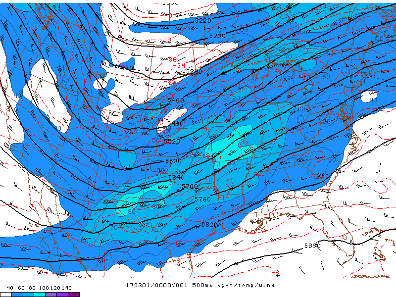
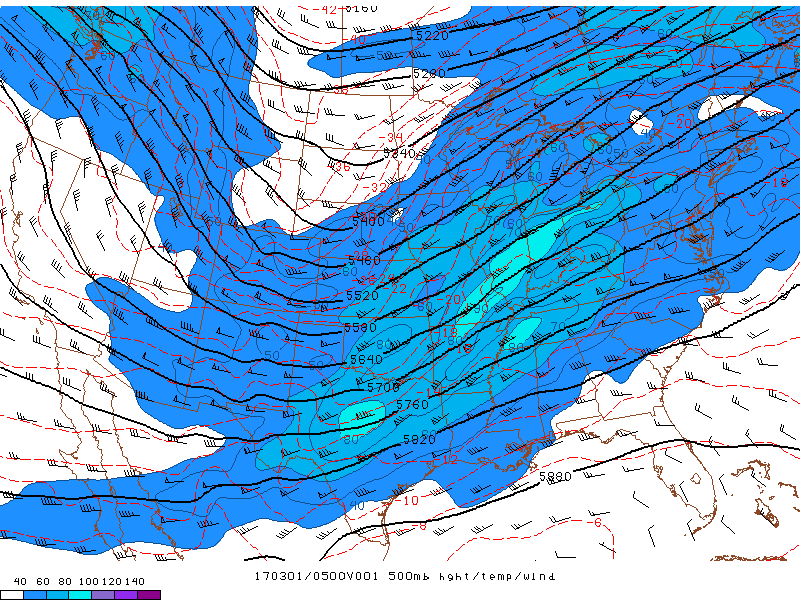
An upper level disturbance was moving out of the Rockies during the day, which induced a broad area of low pressure to develop, and a cold front to form which stretched from eastern Iowa into northwest Texas by Tuesday afternoon. This front progressed eastward toward our area during the evening and overnight hours.
6 PM Analysis:
 |
 |
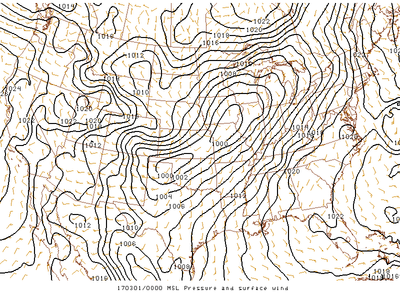 |
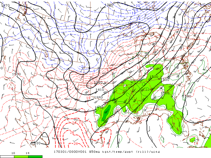
| 500 mb Height, Temperature, & Wind at 6 PM | 850 mb Height, Dewpoint, & Temperature at 6 PM | MSL Pressure and Surface wind at 6 PM |
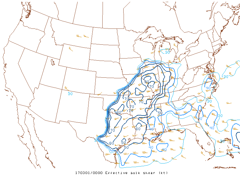
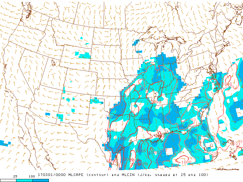
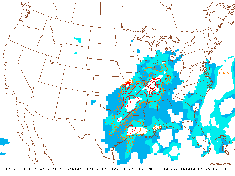
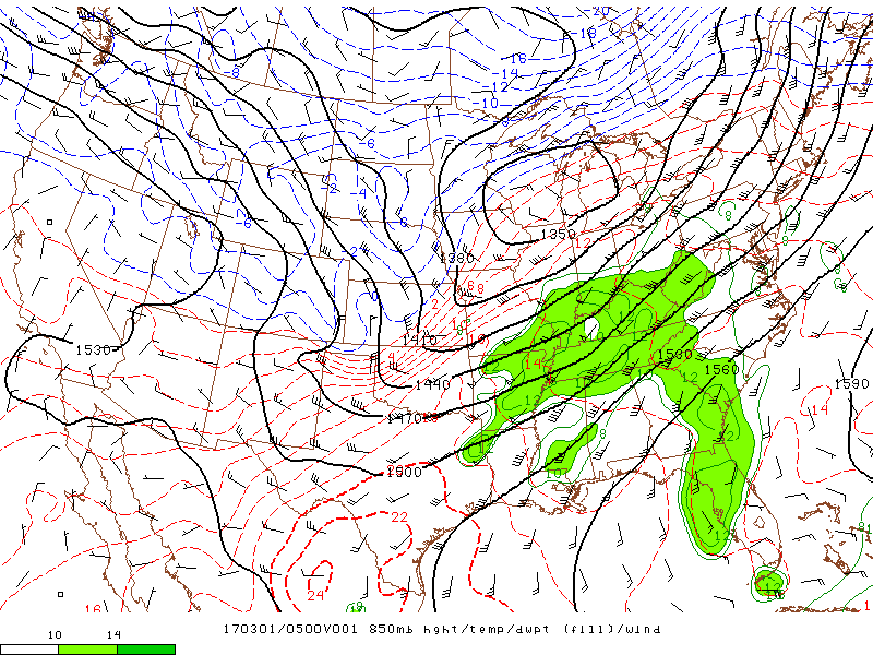
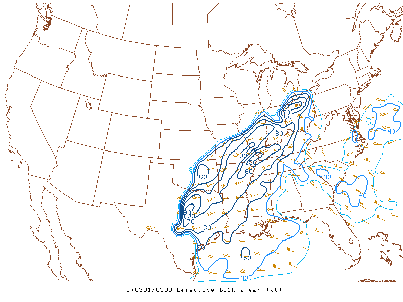
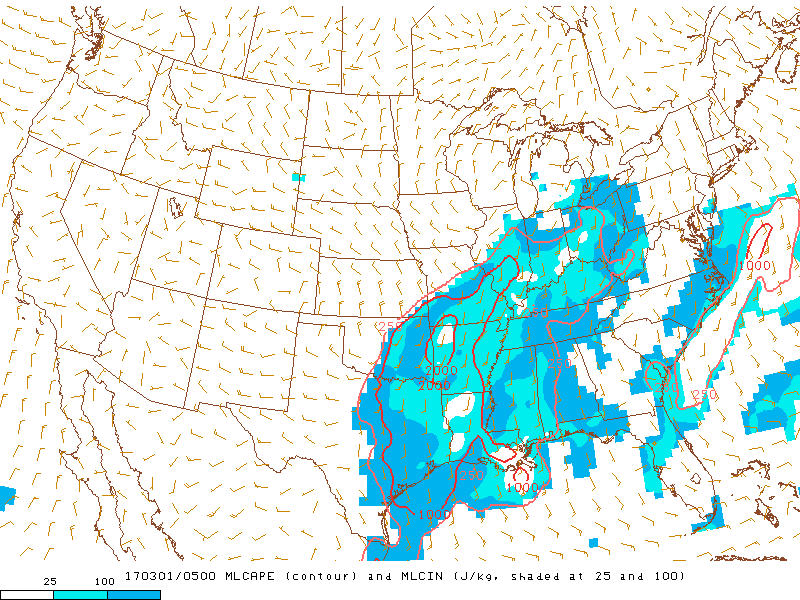
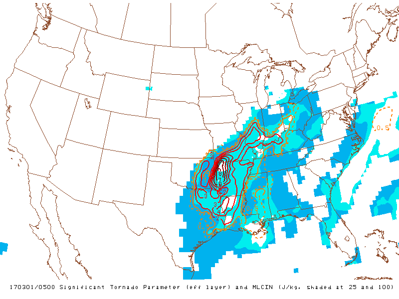
The environment became very conducive for severe storms to develop as ample moisture (surface dewpoints into the low to mid 60s) streamed north from the Gulf of America, along with moderate instability (MLCAPE values over 1000 J/kg), and strong deep layer and low level shear (effective bulk shear values were over 70 knots). The Significant tornado parameter which assesses the ingredients available for tornadic storms, exceeded a 4 across southern Illinois at 8 PM. This was very concerning, indicating an environment that was very favorable for tornadoes to form within any of the storms.
 |
 |
 |
| Effective Bulk Shear valid at 6 PM | MLCAPE valid at 6 PM | Significant Tornado Parameter (STP) valid at 8 PM |
11 PM Analysis:
 |
 |
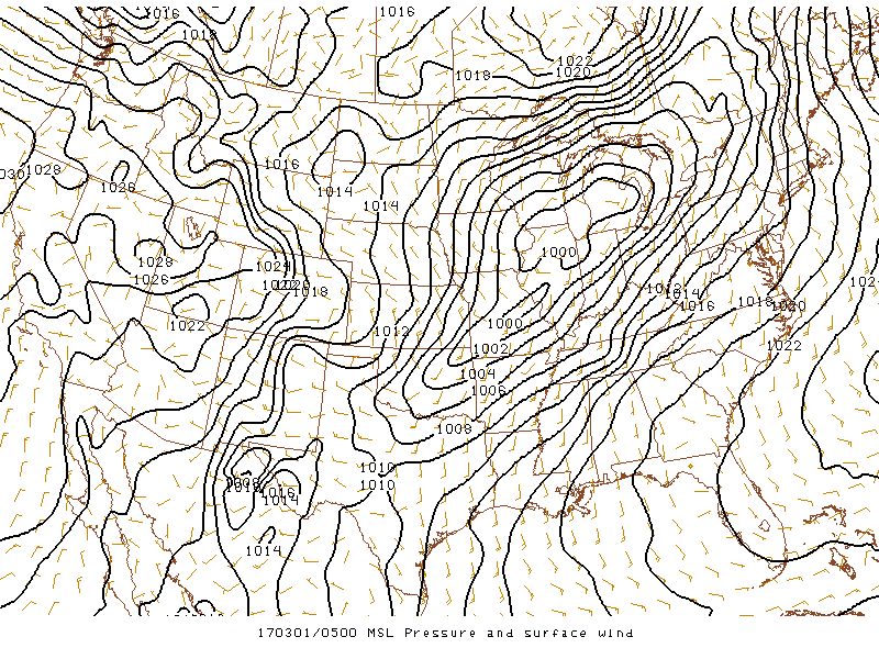 |
| 500 mb Height, Temperature, & Wind at 11 PM | 850 mb Height, Dewpoint, & Temperature at 11 PM | MSL Pressure and Surface wind at 11 PM |
 |
 |
 |
| Effective Bulk Shear valid at 11 PM | MLCAPE valid at 11 PM | Significant Tornado Parameter (STP) valid at 11 PM |
Additional Information (Click images to enlarge them)
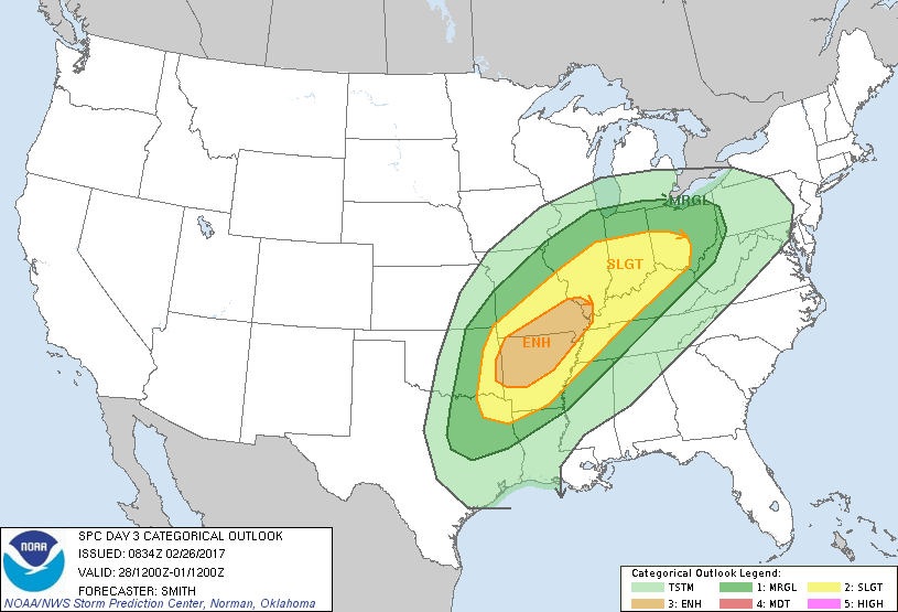
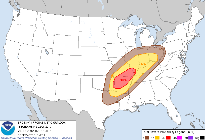
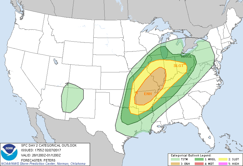
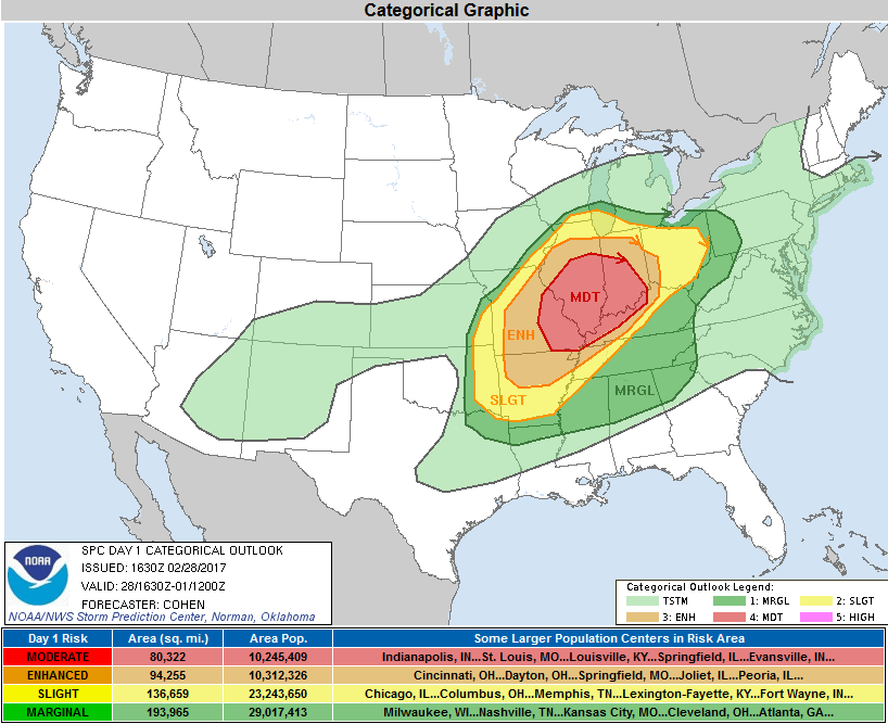
The Forecast
 |
 |
 |
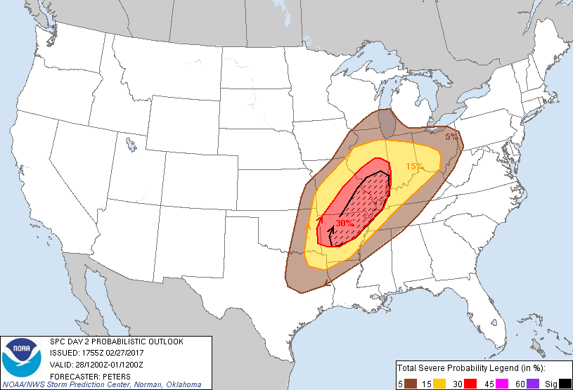 |
| SPC Day 3 Categorical Outlook | SPC Day 3 Probabilistic Outlook | SPC Day 2 Categorical Outlook | SPC Day 2 Probabilistic Outlook |
 |
 |
 |
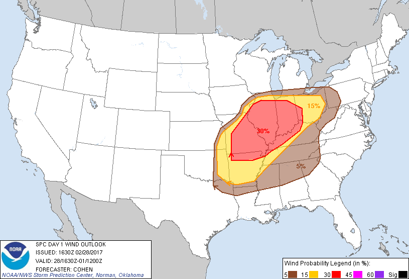 |
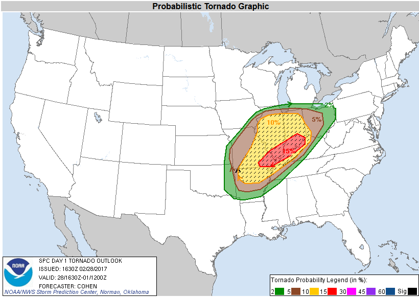
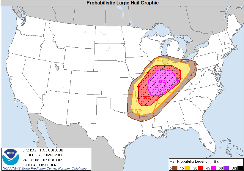
| SPC Day 1 Categorical Outlook | SPC Day 1 Tornado Outlook | SPC Day 1 Hail Outlook | SPC Day 1 Wind Outlook |
 |
Media use of NWS Web News Stories is encouraged! Please acknowledge the NWS as the source of any news information accessed from this site. |
|