
Severe thunderstorms may produce damaging winds, large hail, and numerous instances of flash/urban flooding over parts of the central Plains and lower Missouri Valley. Hazardous heat will continue in the South, Desert Southwest and the California Central Valley this weekend. Isolated dry thunderstorms may increase the risk of fire starts and spread across the Four Corners region and vicinity. Read More >
Top 10 Weather Headlines of 2007
2007 began on a fairly quiet note. No major winter storms occurred, and the spring severe weather season was unusually quiet. Perhaps the biggest weather event of the spring was record or near record warmth in March, followed by record cold in April. Tens of millions of dollars in crop damage occurred, mostly to the winter wheat crop.
The following weather events are ranked unscientifically. The primary ranking factors are the extent of news media coverage, number of fatalities and injuries, and economic impact. The meteorological significance of the event is secondary.
 1. Oct. 18 Tornado Outbreak - For the third consecutive year, a record tornado outbreak occurred during the fall season. For the Paducah National Weather Service forecast area, records were set for the strongest tornado in the month of October, as well as the number of tornadoes in the month of October. For the second time in seven years, the city of Owensboro, KY was struck by an EF-3 tornado. Fortunately, none of the tornadoes resulted in fatalities. All but one of the tornadoes in the NWS Paducah forecast area occurred in western Kentucky. Total damage estimates were between 15 and 20 million dollars for the outbreak. Approximately 20 people were injured. (NWS Photo...Extensive damage to historic church in downtown Owensboro) 1. Oct. 18 Tornado Outbreak - For the third consecutive year, a record tornado outbreak occurred during the fall season. For the Paducah National Weather Service forecast area, records were set for the strongest tornado in the month of October, as well as the number of tornadoes in the month of October. For the second time in seven years, the city of Owensboro, KY was struck by an EF-3 tornado. Fortunately, none of the tornadoes resulted in fatalities. All but one of the tornadoes in the NWS Paducah forecast area occurred in western Kentucky. Total damage estimates were between 15 and 20 million dollars for the outbreak. Approximately 20 people were injured. (NWS Photo...Extensive damage to historic church in downtown Owensboro) |
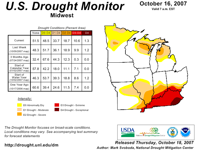 2 . Summer / Early fall Drought - Through mid-October, year-to-date rainfall deficits were 16 to 20 inches over parts of western Kentucky. Drought conditions were rated extreme across western Kentucky and southwest Indiana. A federal disaster declaration was granted for the state of Kentucky, where farmers were hit hard by the drought. The hay crop was very poor. Corn and soybean yields were affected to varying degrees. (Graphic at left shows drought status map at height of drought) 2 . Summer / Early fall Drought - Through mid-October, year-to-date rainfall deficits were 16 to 20 inches over parts of western Kentucky. Drought conditions were rated extreme across western Kentucky and southwest Indiana. A federal disaster declaration was granted for the state of Kentucky, where farmers were hit hard by the drought. The hay crop was very poor. Corn and soybean yields were affected to varying degrees. (Graphic at left shows drought status map at height of drought) |
| 3. Hottest August on record at some locations - The monthly average temperature for August was the highest on record at Paducah and the second highest at Evansville. The highest temperature of the summer reached 105 degrees at Paducah, three degrees below the all-time high for any date. At least several dozen people were treated for heat illnesses, and one fatality was directly caused by the heat. |
| 4. April Freeze following record warm March - At Paducah, the coldest temperature recorded in the month of April occurred on April 8. The low of 21 degrees followed the warmest March on record at Paducah. Around 70 million dollars damage to the winter wheat crop was reported. |
| 5. April 11 Strong Winds - Winds gusted from 40 to 55 mph in the wake of a strong low pressure system over northern Illinois. One person was killed in Lyon County when a tree fell on him. |
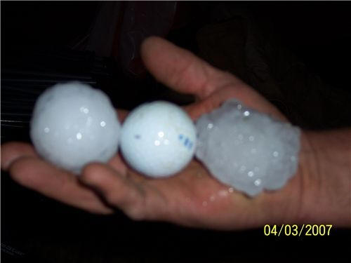 6. April 3 Severe Weather - Thunderstorms were prolific hail producers during this afternoon and early evening outbreak. This was the largest outbreak of the spring season in terms of severe weather reports. The vast majority of severe weather reports were large hail reports, including some larger than golf balls. This severe weather outbreak concluded the unseasonably warm weather that dominated the month of March. (Photo of large hail in Dexter, KY courtesy of Mark Dillon) 6. April 3 Severe Weather - Thunderstorms were prolific hail producers during this afternoon and early evening outbreak. This was the largest outbreak of the spring season in terms of severe weather reports. The vast majority of severe weather reports were large hail reports, including some larger than golf balls. This severe weather outbreak concluded the unseasonably warm weather that dominated the month of March. (Photo of large hail in Dexter, KY courtesy of Mark Dillon) |
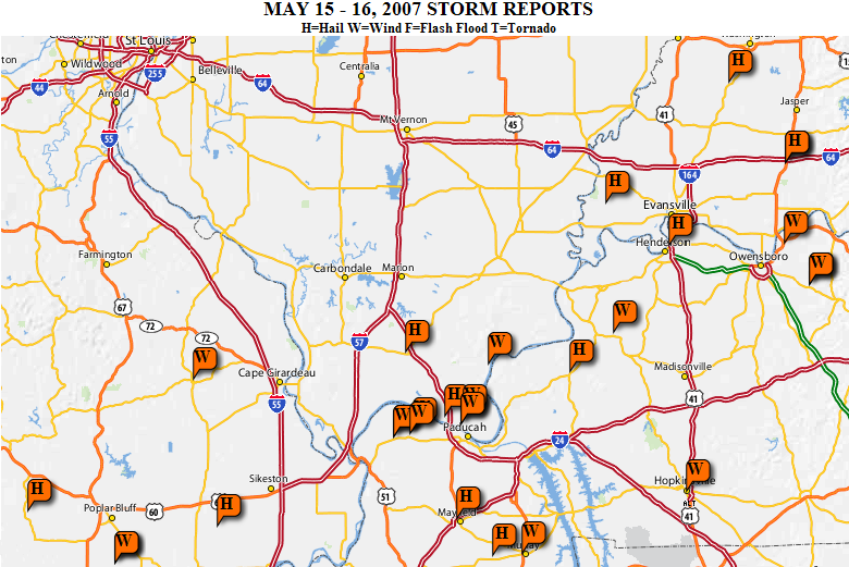 7. May 15 Severe Weather- Another significant severe weather outbreak occurred in mid May. Wind gusts around 60 mph and hail up to an inch in diameter were reported in severe thunderstorms. The number of severe weather events during this outbreak was not as high as April 3. (Map of severe weather events shown at left, click for full size). 7. May 15 Severe Weather- Another significant severe weather outbreak occurred in mid May. Wind gusts around 60 mph and hail up to an inch in diameter were reported in severe thunderstorms. The number of severe weather events during this outbreak was not as high as April 3. (Map of severe weather events shown at left, click for full size). |
| 8. Feb. 20 Hailstorms - The first severe weather outbreak of 2007 occurred during the late winter. Numerous reports of large hail were received, including some up to the size of golf balls. The largest hailstones were reported in southeast Missouri. |
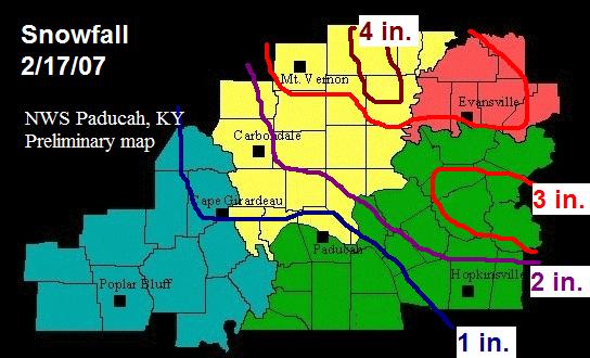 9. February 17 Snowfall - A moderate snowfall of 2 to 4 inches occurred north and east of Paducah. This was the largest snowfall of the winter. The snow melted within several days. (Map of snowfall at left, click for full size). 9. February 17 Snowfall - A moderate snowfall of 2 to 4 inches occurred north and east of Paducah. This was the largest snowfall of the winter. The snow melted within several days. (Map of snowfall at left, click for full size). |
| 10. 2 to 6 inches of rain in mid-January - Numerous roads were covered by water after 2 to 6 inches of rain fell over a four-day period. No major flooding was reported. |
|
Have a safe and happy 2008! |

