Severe Thunderstorms Produce Isolated Damage and a Dust Storm Across Central Arizona
After a very warm morning (lows in the mid 80s F to lower 90s F across the lower deserts), temperatures topped 110 F in many locations during the afternoon of 18 August 2011. Some locations even reached record levels, including Phoenix Sky Harbor International Airport which set a record high of 112 F, breaking the previous record of 111 F set in 1948 and tied in 1973 and 2007.
The hot temperatures combined with high levels of moisture (leading to high levels of atmospheric instability) across Southeast and Eastern Arizona caused scattered thunderstorms to develop by the mid afternoon hours. The rain-cooled outflow winds from these storms coalesced into a large gust front that moved through most of Pinal and Maricopa Counties. The gust front helped spark additional storms that became severe in the San Tan Valley area, with winds in excess of 60 MPH observed due to a downburst (see image below). These severe winds caused some damage, including downed power lines. These severe winds caused a dust storm to develop, which consequently rolled through the Phoenix Metropolitan Area (see image below). Numerous reports of visibility less than 1/4 miles were received by the NWS Phoenix office as the dust storm progressed through the city. Additional storms formed over the Northwest Valley, causing isolated damage there. A list of preliminary storm reports received by NWS Phoenix is found toward the bottom of this page.
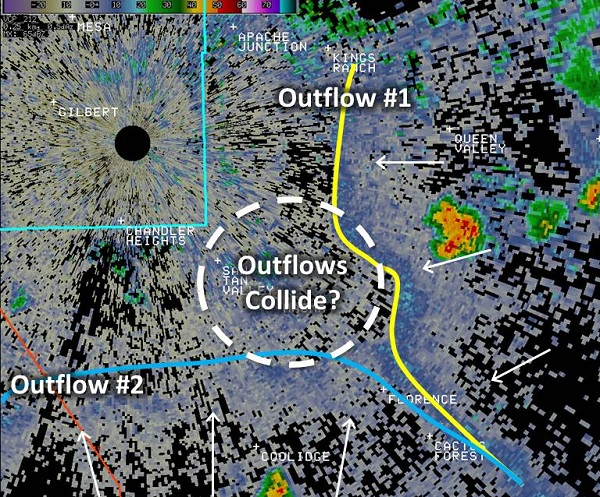
Outflow boundaries approach the far Southeast Valley.
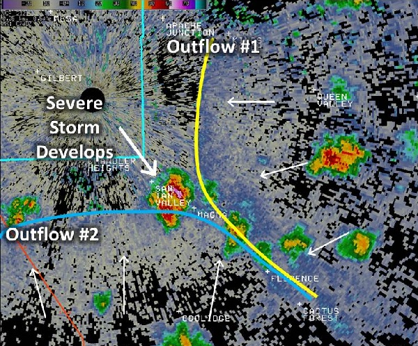
A severe thunderstorm develops near San Tan Valley as the outflow boundaries collide.
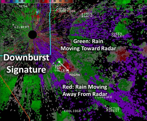
The severe downburst signature can be seen on radar, with winds over 65 MPH measured.
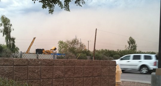
A dust storm approaches Tempe, AZ, a result of the incoming outflow boundaries.
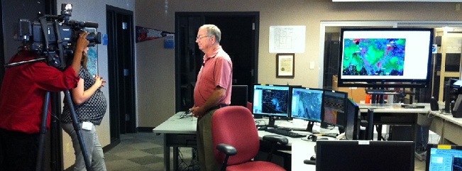
NWS meteorologists were busy the day after responding to media inquiries. Here Ken Waters (Warning Coordination Meteorologist) is interviewed by CBS 5.
 PRELIMINARY LOCAL STORM REPORT...SUMMARY
 NATIONAL WEATHER SERVICE PHOENIX AZ
 1007 PM MST THU AUG 18 2011

 ..TIME...   ...EVENT...      ...CITY LOCATION...     ...LAT.LON...
 ..DATE...   ....MAG....      ..COUNTY LOCATION..ST.. ...SOURCE....
             ..REMARKS..

 0810 PM     HEAVY RAIN       SCOTTSDALE              33.69N 111.87W
 08/18/2011  M1.03 INCH       MARICOPA           AZ   COCORAHS

             RAIN OCCURRED OVER A PERIOD OF ONE HOUR BETWEEN 710 PM
             AND 810 PM.

 0721 PM     DUST STORM       5 ENE EL MIRAGE         33.62N 112.24W
 08/18/2011                   MARICOPA           AZ   TRAINED SPOTTER

             VSBY LESS THAN 1/2 MILE

 0630 PM     TSTM WND GST     3 NW SUN CITY           33.65N 112.32W
 08/18/2011  M62.00 MPH       MARICOPA           AZ   BROADCAST MEDIA

             REPORTED AT ZUNI HILLS ELEMENTARY SCHOOL

 0605 PM     FLOOD            1 SW MAGMA              33.12N 111.51W
 08/18/2011                   PINAL              AZ   AMATEUR RADIO

             FLOODING ON HUNT HIGHWAY IN PINAL COUNTY

 0540 PM     DUST STORM       4 E TEMPE               33.40N 111.86W
 08/18/2011                   MARICOPA           AZ   TRAINED SPOTTER

             VSBY 1/2 MI.

 0523 PM     DUST STORM       MESA                    33.42N 111.74W
 08/18/2011                   MARICOPA           AZ   AWOS

             1/4 MI VSBY MEASURED METAR OBSERVATION AT MESA GATEWAY
             AIRPORT.

 0521 PM     DUST STORM       5 E SUN LAKES           33.22N 111.79W
 08/18/2011                   MARICOPA           AZ   TRAINED SPOTTER

             LESS THAN 1/4 MI. VSBY. G60 MPH.

 0512 PM     DUST STORM       5 E SUN LAKES           33.21N 111.79W
 08/18/2011                   MARICOPA           AZ   TRAINED SPOTTER

             VSBY. LESS THAN 1/4 MI.

 0502 PM     DUST STORM       2 N MARICOPA            33.08N 112.05W
 08/18/2011                   PINAL              AZ   TRAINED SPOTTER

             1/3 MI. VSBY.

 0459 PM     TSTM WND DMG     SAN TAN VALLEY          33.17N 111.57W
 08/18/2011                   PINAL              AZ   LAW ENFORCEMENT

             POWER LINES DOWN AT BELLA VISTA AND GANTZEL...AT LEAST
             ONE POWER LINE FELL ON A SCHOOL BUS.

 0459 PM     DUST STORM       SAN TAN VALLEY          33.17N 111.57W
 08/18/2011                   PINAL              AZ   LAW ENFORCEMENT

             ZERO VISIBILITY ALONG HUNT HIGHWAY.

 0455 PM     DUST STORM       1 SSW SUN LAKES         33.20N 111.88W
 08/18/2011                   PINAL              AZ   TRAINED SPOTTER

             VSBY. LESS THAN 1/4 MI.

 0450 PM     TSTM WND DMG     4 WNW MAGMA             33.16N 111.55W
 08/18/2011                   PINAL              AZ   TRAINED SPOTTER

             60 MPH. WINDS. 1 FT. DIAMETER TREES BLOWN DOWN. ROOF
             BLOWN OFF OF HOUSE. 1/4 IN. HAIL.

 0418 PM     DUST STORM       3 W COOLIDGE            32.98N 111.58W
 08/18/2011                   PINAL              AZ   TRAINED SPOTTER

             1/4 MILE IN BLOWING DUST

 0416 PM     DUST STORM       COOLIDGE                32.98N 111.53W
 08/18/2011                   PINAL              AZ   TRAINED SPOTTER

             1/4 MILE VISIBILITY IN A DUST STORM

