

Widespread Thunderstorms Impact the Sonoran Desert
Updated: 6:00AM 26 August 2008
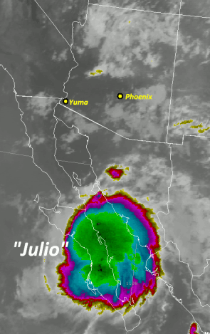
Moisture levels drastically increased across the Sonora Desert during the late morning and early afternoon hours on 25 August 2008, mainly due to Tropical Storm Julio (see image to right). For several days prior to the 25th Julio slowly moved north along Baja Mexico. A large burst of thunderstorms over the central portions of the Gulf of California late on the 24th/early on the 25th resulted in a Gulf Surge - a push of very moist air into the lower deserts. Combined with other favorable atmospheric phenomenon, including a weak upper level low pressure system moving across Nevada and into northern Arizona, widespread showers and thunderstorms developed during the afternoon hours on the 25th.
Showers and thunderstorms broke out across the southwest United States early in the afternoon of August 25th. Thunderstorm activity become very pronounced east and south of Phoenix by 2 PM. By 4 PM a severe thunderstorm was occurring across portions of Gilbert and Chandler. Additional strong to severe thunderstorms developed through the evening hours, eventually evolving into a line of thunderstorms that stretched from near Blythe to Casa Grande (see radar loop below).
As the early morning hours approached heavy rain began to fall across La Paz county - as much as three to four inches in two hours or less. This lead to widespread flooding across La Paz county as reported by the La Paz Sheriff's office. Areas particularly hit hard across La Paz county included Wenden (flooding along the Centennial Wash), Bouse, and Parker.
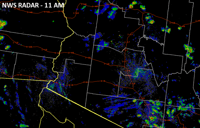
Radar images form the afternoon of the 25th. Click on the image for a radar loop (1.5MB).
 PRELIMINARY LOCAL STORM REPORT...SUMMARY
 NATIONAL WEATHER SERVICE PHOENIX AZ
 622 AM MST TUE AUG 26 2008

 ..TIME...   ...EVENT...      ...CITY LOCATION...     ...LAT.LON...
 ..DATE...   ....MAG....      ..COUNTY LOCATION..ST.. ...SOURCE....
             ..REMARKS..

 0105 PM     DUST STORM       LA PALMA                32.88N 111.51W
 08/25/2008                   PINAL              AZ   TRAINED SPOTTER

             DUST STORM WITH VISIBILITY LEASS THAN 1/8TH OF A MILE

 0134 PM     DUST STORM       ARIZONA CITY            32.75N 111.67W
 08/25/2008                   PINAL              AZ   TRAINED SPOTTER

             50 FT VISIBILITY IN BLOWING DUST.

 0315 PM     TSTM WND GST     2 E GILBERT             33.33N 111.73W
 08/25/2008  E50.00 MPH       MARICOPA           AZ   NWS EMPLOYEE

             ESTIMATED WIND GUST OF 50 KTS. DENSE BLOWING DUST.

 0320 PM     DUST STORM       CHANDLER                33.29N 111.87W
 08/25/2008                   MARICOPA           AZ   NWS EMPLOYEE

             VISIBILITY OF ONE EIGHTH OF A MILE AT PECOS AND COOPER
             ROADS.

 0320 PM     TSTM WND DMG     QUEEN CREEK             33.24N 111.64W
 08/25/2008                   MARICOPA           AZ   TRAINED SPOTTER

             LARGE PALO VERDE TREE UPROOTED. VISIBILITY LESS THAN ONE
             QUARTER OF A MILE IN BLOWING DUST.

 0325 PM     TSTM WND GST     CHANDLER                33.29N 111.87W
 08/25/2008  M67.00 MPH       MARICOPA           AZ   AWOS

             WIND GUST TO 67 MPH AT CHANDLER AIRPORT

 0325 PM     TSTM WND DMG     CHANDLER                33.29N 111.87W
 08/25/2008                   MARICOPA           AZ   BROADCAST MEDIA

             PLANES OVERTURNED AT CHANDLER AIRPORT WHEN AWOS MEASURED
             A 67 MPH WIND GUST.

 0330 PM     TSTM WND DMG     GILBERT                 33.33N 111.76W
 08/25/2008                   MARICOPA           AZ   NWS EMPLOYEE

             LARGE TREE FELL ONTO CHANDLER BLVD BETWEEN COOPER AND
             GILBERT RDS.

 0445 PM     TSTM WND GST     4 ENE AVONDALE          33.44N 112.29W
 08/25/2008  M60.00 MPH       MARICOPA           AZ   TRAINED SPOTTER

             WIND GUST OF 60 MPH NEAR INTERSTATE 10,115 AVENUE AND
             AVONDALE BLVD.

 0515 PM     FLASH FLOOD      4 S LAVEEN              33.36N 112.13W
 08/25/2008                   MARICOPA           AZ   BROADCAST MEDIA

             HOUSES FLOODED AND WATER RESCUES FROM FLASH FLOOD AT 35TH
             AVE AND DOBBINS

 0130 AM     FLASH FLOOD      WENDEN                  33.82N 113.55W
 08/26/2008                   LA PAZ             AZ   LAW ENFORCEMENT

             FLASH FLOODING IN WENDEN DUE TO CENTENNIAL WASH
             OVERFLOWING ITS BANKS.

 0130 AM     FLASH FLOOD      BOUSE                   33.92N 114.00W
 08/26/2008                   LA PAZ             AZ   LAW ENFORCEMENT

             SWIFT WATER RESCUE ALONG HIGHWAY 72 MILE MARKER 31...NEAR
             BOUSE.