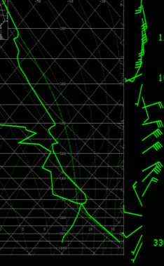
Weather balloon data from the evening of the 28th. Note the large amount of instability with the weak cap. Also note the deep northeasterly flow in the mid levels.
During the day of the 28th, the sky was mostly clear across central Arizona. Early indications were that strong to severe thunderstorms were possible that evening, though by mid-afternoon little thunderstorm activity had developed. The weather balloon sounding data from Phoenix Thursday evening indicated that the atmosphere remained very unstable though a cap remained - analogous to a lid on a pot of boiling water (see graphic to right). In addition winds in the mid levels of the atmosphere were over 45 mph from the northeast, strongly unusual and indicative that thunderstorms that develop northeast of Phoenix will quickly move into the lower deserts and be capable of producing damaging winds.
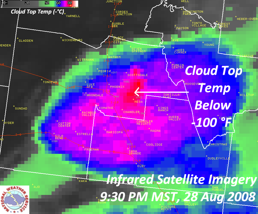
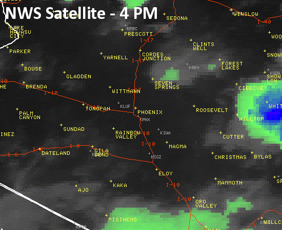
Infrared satellite imagery. Click on the image for a larger version.
Shortly after 8 PM, thunderstorms began to develop east of Phoenix and moved into the potentially very unstable airmass. The thunderstorms themselves provided enough lift to release the stored energy - they took the lid off the pot. In the ensuing four hours severe thunderstorms spread across much of the south central Arizona, including much of the Phoenix Metropolitan Area. These were not your typical monsoon thunderstorms. NWS meteorologists noted the exceptionally strong structure of the thunderstorms, with the storms themselves extending up to 60,000 feet in the atmosphere. At this height the temperature of the tops of the thunderstorms was below -110 deg F (see graphic to right). For a satellite image loop, click here (0.8 MB).
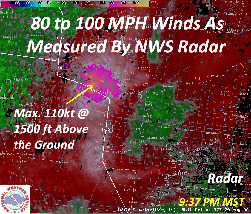
80 to 100 mph winds measured by radar. Click on the image above for a full size version with accompanying text.
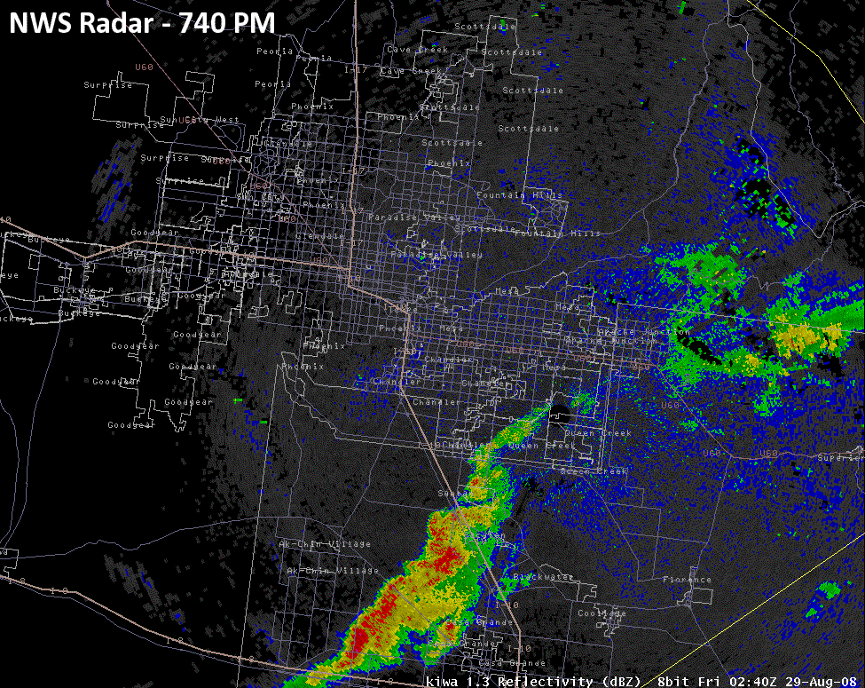
As the evening unfolded several waves of thunderstorms, about four in total, developed generally east or northeast of Phoenix and moved to the west or southwest at speeds ranging from 20 to 40 mph. For a radar loop of the full event click here (large file - 17 MB). Early on it became evident that these thunderstorms would be capable of producing severe and damaging winds. This is what in fact happened as significant bow echoes developed within each wave. The highest measured wind speed reported to the NWS was 85 MPH, which occurred near central Phoenix. Phoenix Sky Harbor International Airport reached 75 mph. Even the NWS office in Tempe was hit by the damaging winds. NWS meteorologists estimated winds to be at or above 80 MPH at the NWS office. Winds may have actually been higher than reported by any ground-based weather station as the National Weather Service radar recorded winds in excess of 100 MPH just 1,500 feet above the ground (see to right). For a loop of velocity radar data click here (large file - 14 MB).
The National Weather Service in Phoenix issued twenty Severe Thunderstorm Warnings and received thirty reports of severe weather during the event. The most significant wind measured was a wind gust of 85 MPH 4 miles SSE of downtown Phoenix by a trained weather spotter. The very strong winds resulted in widespread damage, with central Phoenix and north Tempe taking the brunt of the storm. Media coverage indicated that downed trees occurred over a large area with perhaps thousands of trees lost during the storm. Structural damage was also observed. The images below were taken by NWS Employees. Click on each thumbnail for a full version image.
Another interesting angle which indicates just how strong these thunderstorms were is the fact that a record low for the date was tied at Phoenix Sky Harbor International Airport. During the height of the thunderstorms the temperature dropped to 64 degrees. This tied the record low for the date, previously set in 1920. The setting or tying of a record low temperature at Sky Harbor has become a rare event during the past two decades. Record high lows have become much more prevalent primarily due to the expansion and intensification of the urban heat island. In fact this was the first record low that has been set or tied since 23 December 1990 - nearly twenty years. It was also the first record low set or tied during the summer since 1979 and during August since 1968 (forty years!). These numbers indicate just how strong the thunderstorms were that impacted the Phoenix area.
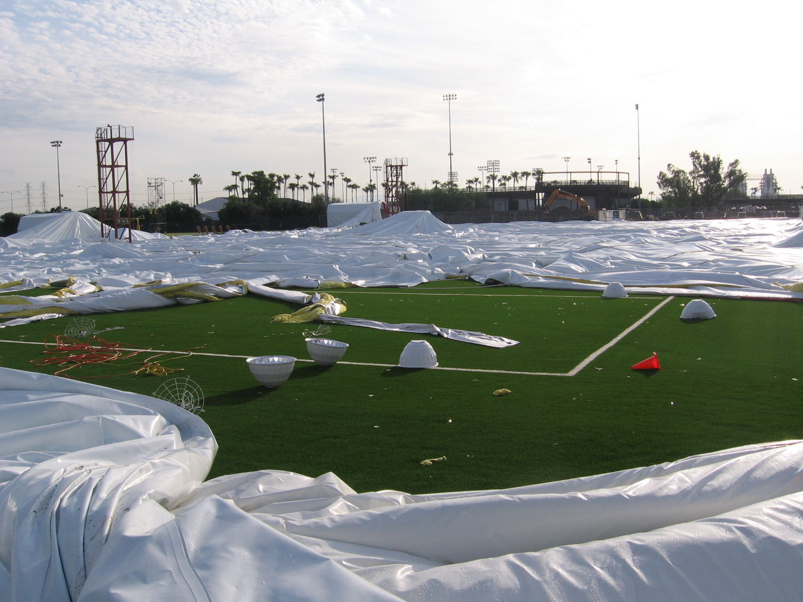
The ASU football practice field was destroyed by the winds.
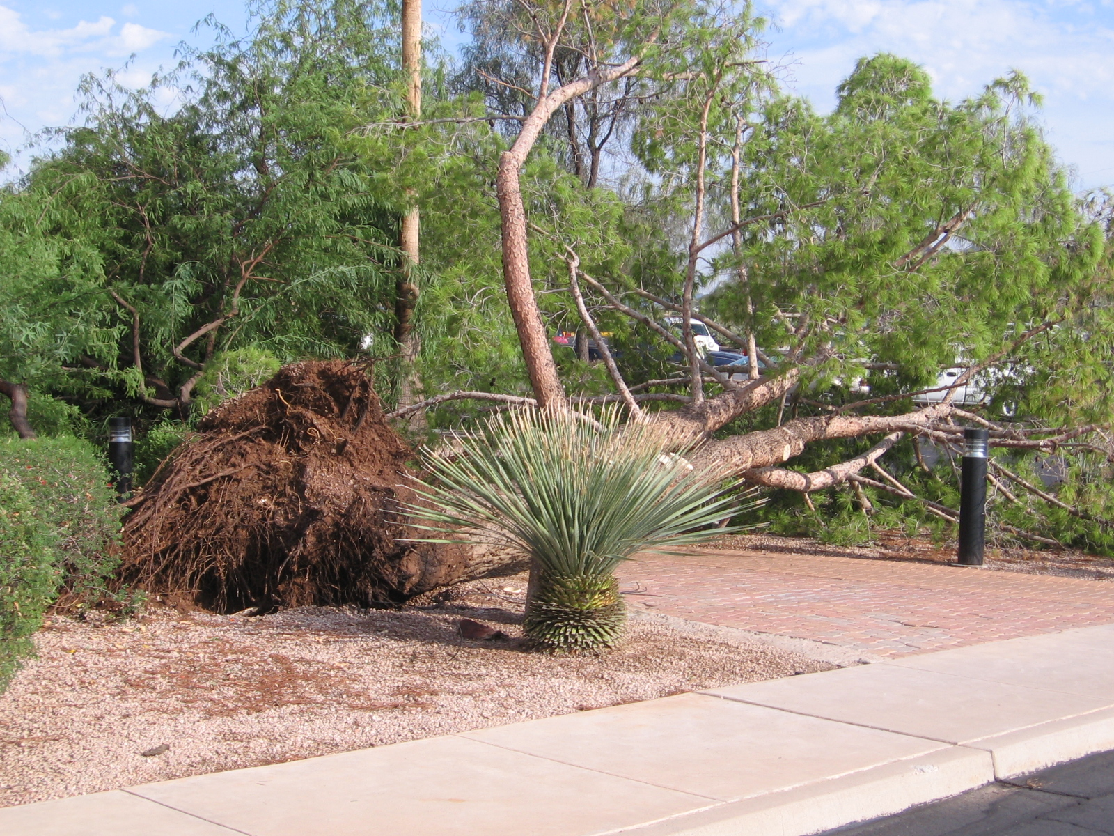
It is likely that thousands of trees like these fell during the storm.
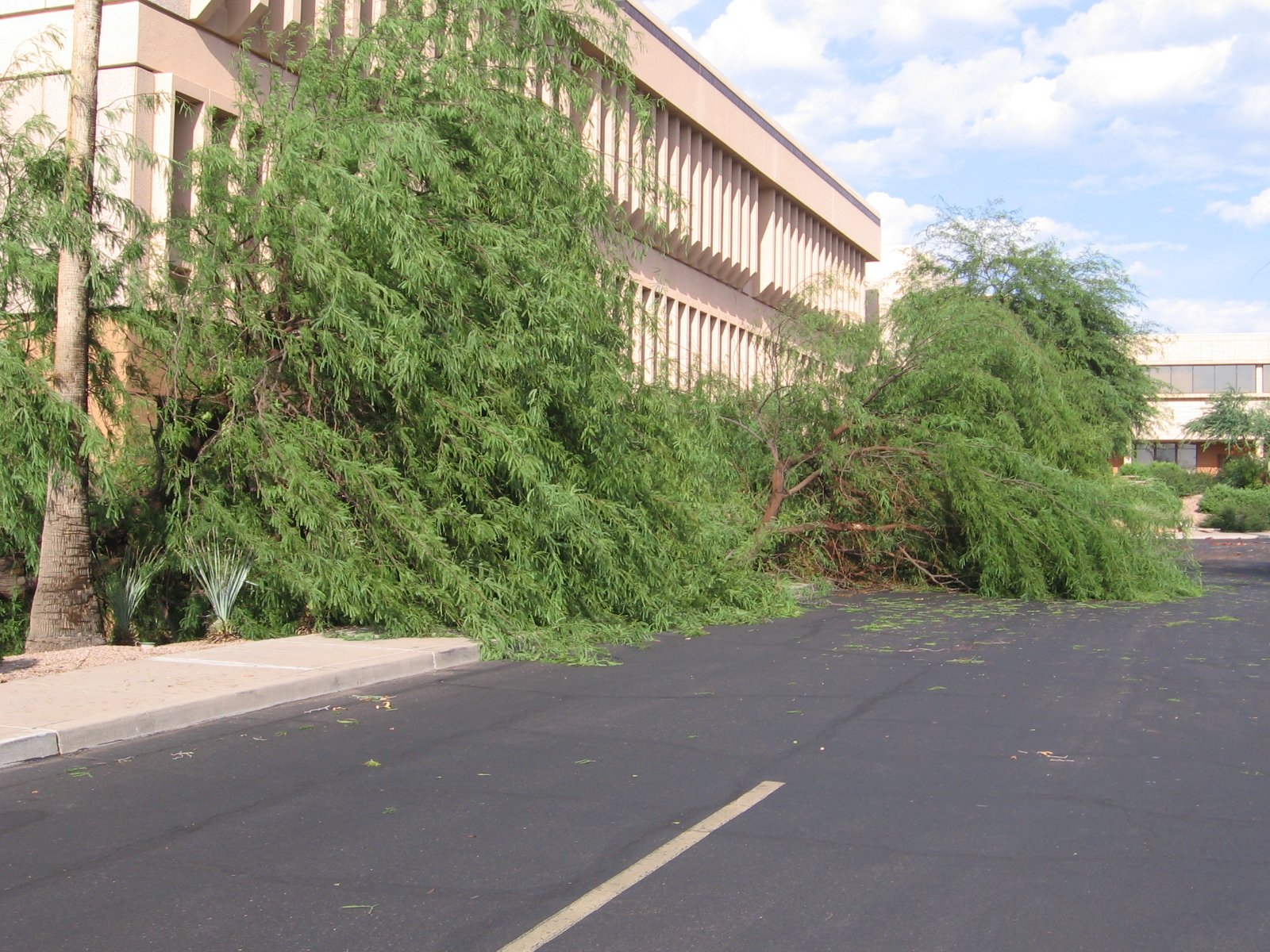
It is likely that thousands of trees like these fell during the storm.
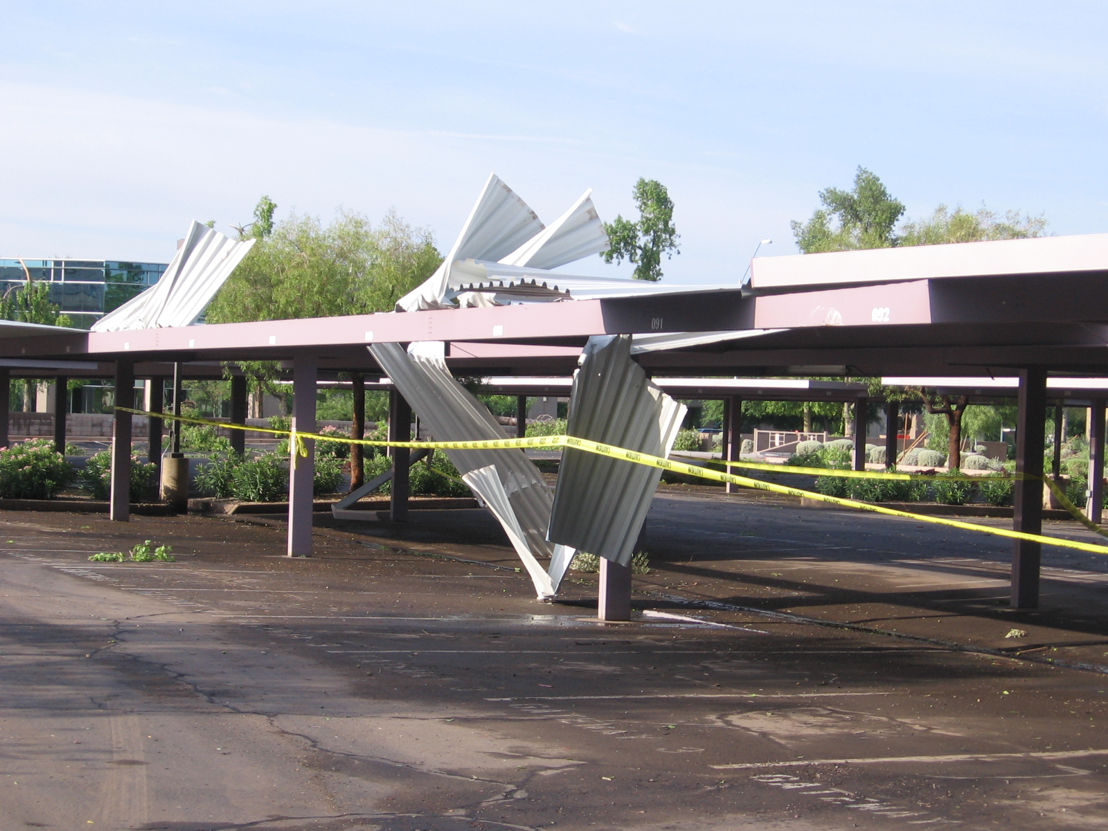
This covered parking was no match for the strong winds.
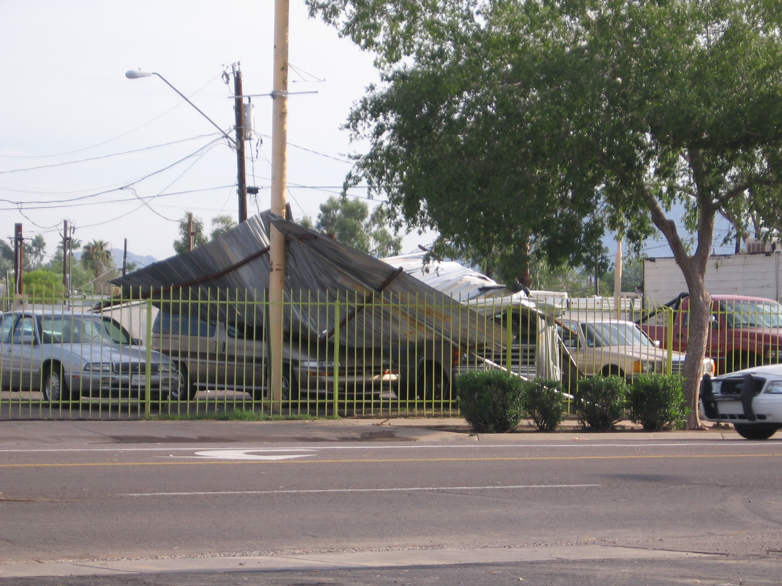
More structural damage.
 PRELIMINARY LOCAL STORM REPORT...SUMMARY
 NATIONAL WEATHER SERVICE PHOENIX AZ

 ..TIME...   ...EVENT...      ...CITY LOCATION...     ...LAT.LON...
 ..DATE...   ....MAG....      ..COUNTY LOCATION..ST.. ...SOURCE....
             ..REMARKS..

 0825 PM     TSTM WND GST     2 S CHANDLER            33.27N 111.87W
 08/28/2008  M77.00 MPH       MARICOPA           AZ   AWOS

             CHANDLER AIRPORT

 0830 PM     HEAVY RAIN       5 S CHANDLER            33.22N 111.88W
 08/28/2008  M0.22 INCH       MARICOPA           AZ   AMATEUR RADIO

             0.22 INCH IN 5 MINS

 0830 PM     HEAVY RAIN       3 ENE CHANDLER          33.31N 111.82W
 08/28/2008  M0.50 INCH       MARICOPA           AZ   TRAINED SPOTTER

             0.5 INCH RAIN IN 10 MINS

 0840 PM     HEAVY RAIN       5 W CHANDLER            33.29N 111.95W
 08/28/2008  E0.50 INCH       MARICOPA           AZ   TRAINED SPOTTER

             0.5 INCH IN 30 MINS.

 0850 PM     HAIL             7 SW GUADALUPE          33.30N 112.06W
 08/28/2008  E0.75 INCH       MARICOPA           AZ   TRAINED SPOTTER

             3/4 INCH HAIL REPT LIBERTY LN AND DESERT FOOTHILLS PKWY

 0850 PM     HAIL             4 SW GUADALUPE          33.32N 112.00W
 08/28/2008  E0.75 INCH       MARICOPA           AZ   NWS EMPLOYEE

 0906 PM     HAIL             NW MARICOPA             33.06N 112.05W
 08/28/2008  E0.25 INCH       PINAL              AZ   TRAINED SPOTTER

             1/4 INCH HAIL COMPLETELY COVERING GROUND

 0910 PM     HEAVY RAIN       1 SW KINGS RANCH        33.37N 111.45W
 08/28/2008  M0.50 INCH       PINAL              AZ   TRAINED SPOTTER

             HALF INCH RAIN IN 9 MINUTES

 0912 PM     HEAVY RAIN       4 E APACHE JUNCTION     33.40N 111.48W
 08/28/2008  M0.00 INCH       PINAL              AZ   TRAINED SPOTTER

             0.27 INCH RAIN IN 7 MINUTES

 0919 PM     HEAVY RAIN       2 NW APACHE JUNCTION    33.42N 111.57W
 08/28/2008  E0.00 INCH       PINAL              AZ   TRAINED SPOTTER

             1.2 INCH IN 25 MINS

 0920 PM     TSTM WND GST     3 NE MESA               33.45N 111.70W
 08/28/2008  E75.00 MPH       MARICOPA           AZ   TRAINED SPOTTER

             RECKER AND BROWN

 0920 PM     HAIL             3 NE MESA               33.45N 111.70W
 08/28/2008  E0.75 INCH       MARICOPA           AZ   TRAINED SPOTTER

             BROWN AND RECKER IN EAST MESA

 0921 PM     HEAVY RAIN       5 WSW APACHE JUNCTION   33.39N 111.63W
 08/28/2008  M0.00 INCH       MARICOPA           AZ   TRAINED SPOTTER

             0.5 INCH IN 15 MINS AT ELLSWORTH AND SOUTHERN

 0930 PM     TSTM WND DMG     5 SSW PARADISE VALLEY   33.47N 111.98W
 08/28/2008                   MARICOPA           AZ   TRAINED SPOTTER

             TREES DOWN 48TH ST AND MCDOWELL WITH 40 MPH WINDS

 0938 PM     TSTM WND GST     6 NW TEMPE              33.44N 112.01W
 08/28/2008  M75.00 MPH       MARICOPA           AZ   ASOS

             MEASURED ASOS AT PHX AIRPORT

 0940 PM     HAIL             4 SW GUADALUPE          33.32N 112.01W
 08/28/2008  E0.75 INCH       MARICOPA           AZ   TRAINED SPOTTER

             32ND AND RAY

 0940 PM     HAIL             4 SW GUADALUPE          33.32N 112.01W
 08/28/2008  E0.75 INCH       MARICOPA           AZ   TRAINED SPOTTER

 0940 PM     HAIL             4 SW GUADALUPE          33.32N 112.01W
 08/28/2008  E0.75 INCH       MARICOPA           AZ   TRAINED SPOTTER

             32ND AND RAY IN AHWATUKEE

 1000 PM     HAIL             4 SW GUADALUPE          33.32N 112.01W
 08/28/2008  E0.75 INCH       MARICOPA           AZ   TRAINED SPOTTER

 1010 PM     TSTM WND GST     4 SSE PHOENIX           33.48N 112.05W
 08/28/2008  M85.00 MPH       MARICOPA           AZ   AMATEUR RADIO

             MEASURED WIND GUST 16TH ST AND THOMAS

 1015 PM     TSTM WND GST     WSW ESTRELLA            33.00N 112.42W
 08/28/2008  M69.00 MPH       MARICOPA           AZ   TRAINED SPOTTER

             ESTRELLA PKWY AND ELLIOT

 1015 PM     DUST STORM       4 SW WADDELL            33.54N 112.41W
 08/28/2008                   MARICOPA           AZ   TRAINED SPOTTER

             1/4 MI VIS IN DUST STORM 4 MI WEST OF LUKE AFB

 1043 PM     TSTM WND DMG     5 N AVONDALE            33.49N 112.36W
 08/28/2008                   MARICOPA           AZ   TRAINED SPOTTER

             2 FOOT DIAM TREE DOWN

 1101 PM     HAIL             6 WSW FOUNTAIN HILLS    33.58N 111.84W
 08/28/2008  E0.75 INCH       MARICOPA           AZ   TRAINED SPOTTER

             FRANK LLOYD WRIGHT AND SHEA

 1105 PM     HAIL             5 NNE PARADISE VALLEY   33.61N 111.93W
 08/28/2008  E0.75 INCH       MARICOPA           AZ   TRAINED SPOTTER

             SCOTTSDALE AND THUNDERBIRD

 1105 PM     HAIL             3 S SCOTTSDALE          33.64N 111.86W
 08/28/2008  E0.75 INCH       MARICOPA           AZ   TRAINED SPOTTER

             104ST AND BELL

 1130 PM     HAIL             5 NNE PARADISE VALLEY   33.61N 111.93W
 08/28/2008  E0.75 INCH       MARICOPA           AZ   TRAINED SPOTTER

             SCOTTSDALE AND THUNDERBIRD

 1130 PM     HAIL             2 W PHOENIX             33.54N 112.10W
 08/28/2008  E0.75 INCH       MARICOPA           AZ   TRAINED SPOTTER

             18TH AND GLENDALE

 1130 PM     TSTM WND DMG     2 W PHOENIX             33.54N 112.10W
 08/28/2008                   MARICOPA           AZ   TRAINED SPOTTER

             18 INCH DIAM TREE DOWN

 1140 PM     HAIL             2 WSW PARADISE VALLEY   33.53N 111.98W
 08/28/2008  E1.00 INCH       MARICOPA           AZ   TRAINED SPOTTER

             TATUM AND LINCOLN

