

Severe Weather Hits Southwest/Central Arizona
Updated: 6:10 AM MST July 11, 2008
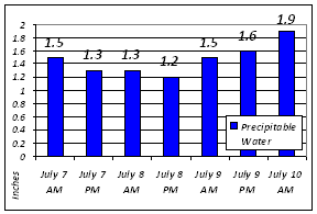
Precipitable water values for Phoenix from the morning of July 7 through the morning of July 10.
Leading up to July 10th, a low pressure system had been slowly moving north along the mountains of central and northern Mexico and toward Arizona. As the system moved closer, moisture levels in the atmosphere continued to steadily increase. By the morning of July 10th, the precipitable water (a measure of how much water is in a column of air) was nearly two inches - considered exceedingly moist. As temperatures warmed to near 100 degrees during the afternoon of the 10th, instability levels in the atmosphere became high.
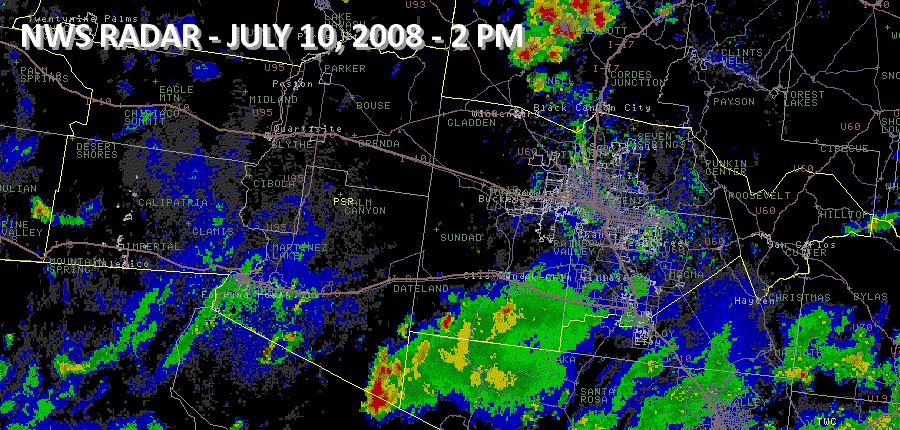
Thunderstorms erupted across the southern half of Arizona by mid-afternoon. A cluster of severe thunderstorms moved across La Paz, northern Yuma, and northwest Maricopa counties, causing strong winds and dense blowing dust. Meanwhile, a second cluster of severe thunderstorms developed over west-central Gila county and moved to the west. The stage was set for these systems to collide over the Phoenix Metropolitan Area. The colliding storms, fueled by the unusually moist and unstable airmass, produced widespread heavy rain and strong/damaging winds. The National Weather Service in Phoenix fielded well over 100 calls from local trained NWS spotters of either strong winds, thunderstorm damage, or flash flooding. Click here to see some of the reports. Click here for a RADAR loop of the event (1.4MB).
Several areas across Phoenix experienced flash flooding due to the high rainfall amounts. RADAR-derived rainfall totals and Data courtesy of the Flood Control District of Maricopa County (see maps below) indicated that four areas were hit particularly hard by this event. They included the Wickenburg area (1 to 3 inches), central Phoenix (1 to 3 inches), northeast Mesa (1 to 3 inches), and the area southeast of Queen Creek (2 to 4 inches).
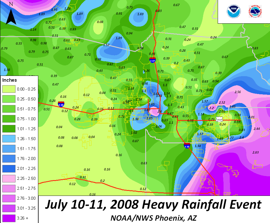

Click here to see 24 hour rainfall amounts for the Phoenix Metro Area.
 PRELIMINARY LOCAL STORM REPORT...SUMMARY
 NATIONAL WEATHER SERVICE PHOENIX AZ

 ..TIME...   ...EVENT...      ...CITY LOCATION...     ...LAT.LON...
 ..DATE...   ....MAG....      ..COUNTY LOCATION..ST.. ...SOURCE....
             ..REMARKS..

 0340 PM     DUST STORM       TACNA                   32.70N 113.95W
 07/10/2008                   YUMA               AZ   TRAINED SPOTTER

             VISIBILITY LESS THAN 1/8 MILE

 0426 PM     DUST STORM       LIGURTA                 32.67N 114.30W
 07/10/2008                   YUMA               AZ   TRAINED SPOTTER

             VISIBILITY LESS THAN 1/4 MILE

 0500 PM     DUST STORM       1 WSW WENDEN            33.81N 113.57W
 07/10/2008                   LA PAZ             AZ   TRAINED SPOTTER

             VISIBILITY NEAR ZERO, WINDS 35MPH

 0620 PM     TSTM WND GST     ROOSEVELT               33.67N 111.13W
 07/10/2008  E50.00 MPH       GILA               AZ   TRAINED SPOTTER

 0620 PM     TSTM WND GST     ROOSEVELT               33.67N 111.13W
 07/10/2008  E50.00 MPH       GILA               AZ   TRAINED SPOTTER

             50-PLUS MPH WIND ESTIMATED BY TRAINED SPOTTER.

 0700 PM     FLASH FLOOD      6 W VICKSBURG           33.75N 113.83W
 07/10/2008                   LA PAZ             AZ   DEPT OF HIGHWAYS

             ROADWAY FLOODING ALONG SR-72 AND INTERSTATE 10...MILE
             POST 40 TO MILE POST 45

 0727 PM     TSTM WND GST     APACHE JUNCTION         33.40N 111.55W
 07/10/2008  M42.00 MPH       PINAL              AZ   TRAINED SPOTTER

 0727 PM     TSTM WND GST     APACHE JUNCTION         33.40N 111.55W
 07/10/2008  M89.00 MPH       PINAL              AZ   TRAINED SPOTTER

 0731 PM     TSTM WND GST     APACHE JUNCTION         33.54N 111.61W
 07/10/2008  E67.00 MPH       PINAL              AZ   TRAINED SPOTTER

             MEASURED WIND GUST OF 67MPH

 0731 PM     TSTM WND GST     APACHE JUNCTION         33.40N 111.55W
 07/10/2008  M50.00 MPH       PINAL              AZ   TRAINED SPOTTER

 0743 PM     TSTM WND DMG     MESA                    33.42N 111.75W
 07/10/2008                   MARICOPA           AZ   TRAINED SPOTTER

             TREE LIMBS DOWN...MEASURED 40MPH GUST

 0754 PM     TSTM WND GST     SCOTTSDALE              33.47N 111.93W
 07/10/2008  E65.00 MPH       MARICOPA           AZ   TRAINED SPOTTER

             SUSTAINED 50 MPH...GUSTS TO 65MPH

 0809 PM     FLASH FLOOD      2 N QUARTZSITE          33.70N 114.21W
 07/10/2008                   LA PAZ             AZ   DEPT OF HIGHWAYS

             ROADWAY FLOODING ALONG STATE ROUTE/US HIGHWAY 95...NORTH
             OF QUARTZSITE...MILE POST 115

 0840 PM     FLASH FLOOD      PHOENIX                 33.56N 112.09W
 07/10/2008                   MARICOPA           AZ   TRAINED SPOTTER

             REPORTED STREET FLOODING...WATER CURB TO CURB...DUNLAP
             AND 19TH AVE.

 0845 PM     TSTM WND DMG     TEMPE                   33.39N 111.93W
 07/10/2008                   MARICOPA           AZ   TRAINED SPOTTER

             TREE LIMBS DOWN AT BASELINE AND MCCLINTOCK.

 0852 PM     FLASH FLOOD      PHOENIX                 33.43N 112.10W
 07/10/2008                   MARICOPA           AZ   TRAINED SPOTTER

             STANDING WATER ON ROADWAY AND UNDERPASS...INTERSTATE 17
             AND BUCKEYE

 0925 PM     FLASH FLOOD      MESA                    33.47N 111.68W
 07/10/2008                   MARICOPA           AZ   AMATEUR RADIO

             ROAD CLOSURE TO DUE WATER ON ROADWAY...POWER RD. AND
             ARIZONA LOOP 202

 1108 PM     FLASH FLOOD      MESA                    33.42N 111.74W
 07/10/2008                   MARICOPA           AZ   LAW ENFORCEMENT

             ON/OFF RAMPS TO HWY 60 CLOSED AT GILBERT ROAD. REPORTED
             BY DPS.