 |
 |
|
4:33pm - 5:44pm |
4:33pm - 5:44pm Click to load loop |
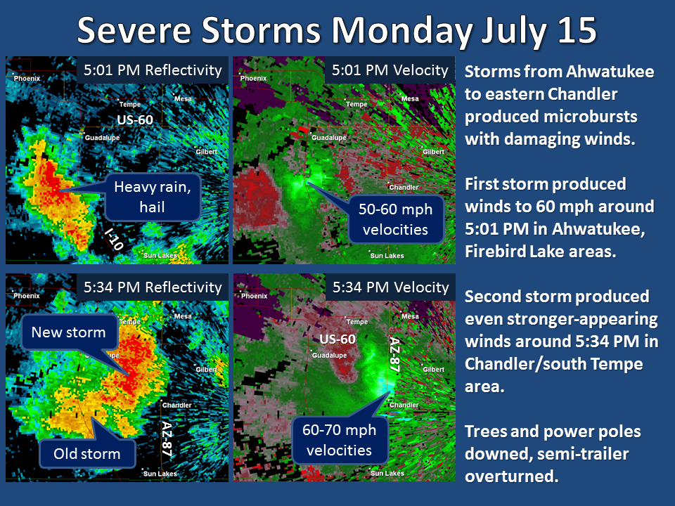
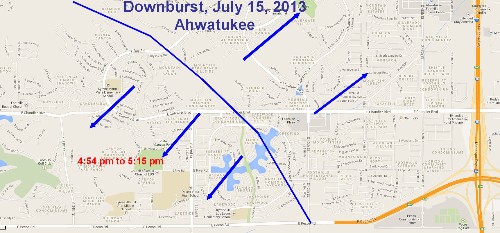
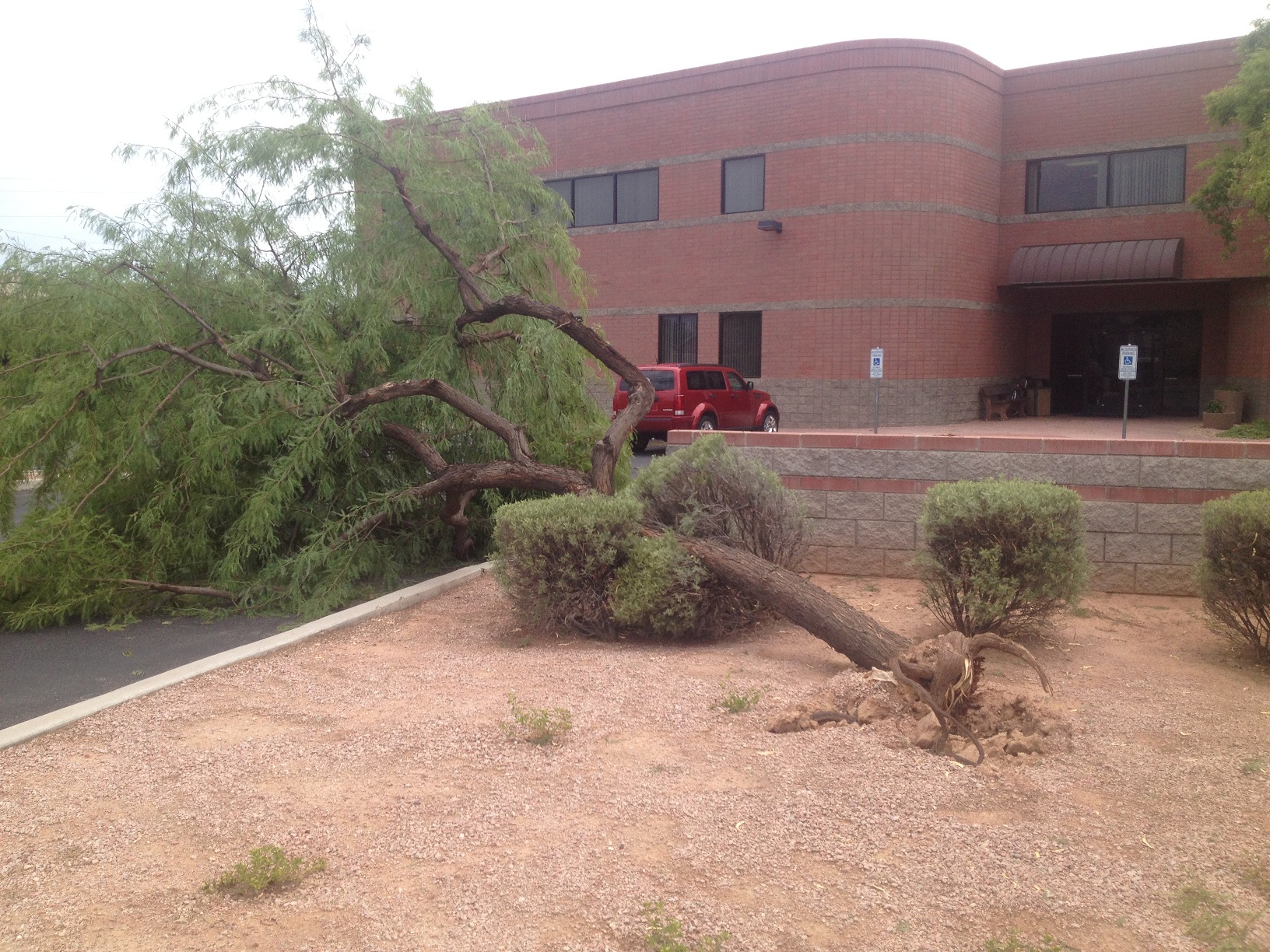
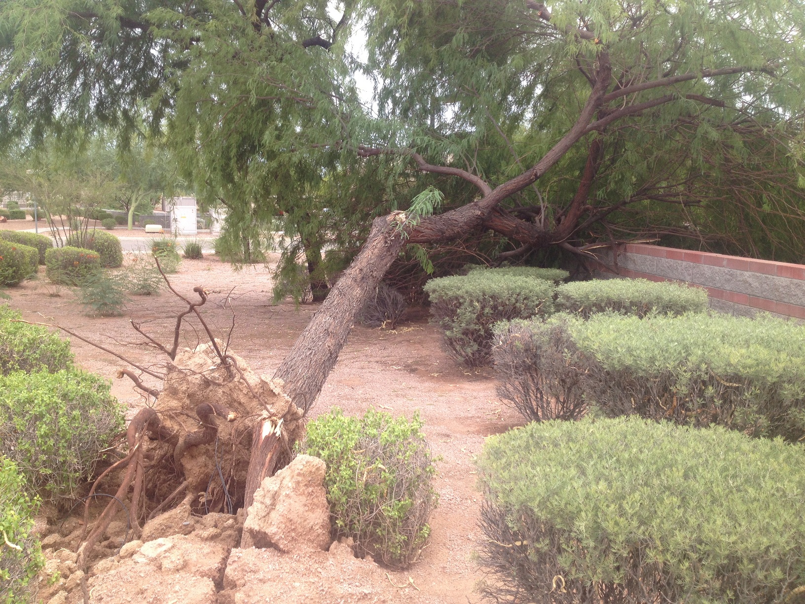
Downbursts are common across the region during the Monsoon, and several occurred during the afternoon hours of Monday July 15th. The most severe damage occurred in the Ahwatukee Foothills area of Phoenix around 5 PM. The National Weather Service conducted an assessment on Tuesday July 16th, and multiple areas of damage were noted in an area of approximately 3 miles in diameter. There were numerous trees down, some of which were in excess of one foot in diameter. Also, damage was seen in homes (roof damage due to falling trees), primarily from strong winds from the Northeast. Some damage was evident from flying debris from a nearby construction site.
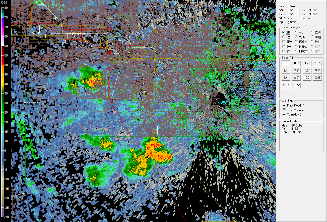
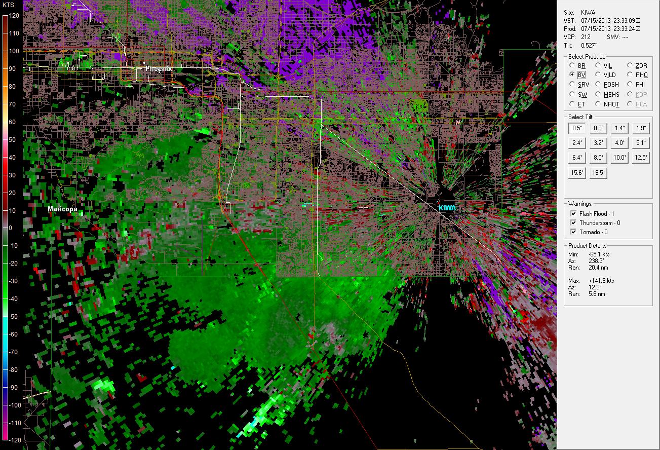
The downburst began around 4:54 PM based on doppler radar imagery. The KIWA doppler radar indicated winds up to 60 mph for 15 minutes after the initial downburst.
Based on roof damage and the size of the trees that were uprooted, the National Weather Service estimates that maximum wind speeds were between 80 and 90 mph. Below are several images of damage in the Ahwatukee Foothills area, as well as a map outlining the area of greatest damage based upon the survey.
 |
 |
 |
 |
 |
 |
 |
 |
 |
 |
 |
 |
 |
 |
 |
 |
 |
 |
 |
 |
 |
 |
PRELIMINARY LOCAL STORM REPORT...SUMMARY
NATIONAL WEATHER SERVICE PHOENIX AZ
745 AM MST TUE JUL 16 2013

..TIME...   ...EVENT...      ...CITY LOCATION...     ...LAT.LON...
..DATE...   ....MAG....      ..COUNTY LOCATION..ST.. ...SOURCE....
            ..REMARKS..

0454 PM     TSTM WND GST     1 SW AHWATUKEE          33.31N 112.02W
07/15/2013  E60 MPH          MARICOPA           AZ   TRAINED SPOTTER

            0.25 INCH HAIL.

0457 PM     TSTM WND DMG     1 SW AHWATUKEE          33.31N 112.02W
07/15/2013                   MARICOPA           AZ   TRAINED SPOTTER

            NEAR 30TH STREET AND CHANDLER BLVD. PEA TO MARBLE SIZE
            HAIL WITH 45-55 MPH THUNDERSTORM WIND GUSTS. NUMEROUS
            LARGE TREES BLOWN DOWN.

0505 PM     TSTM WND DMG     1 N FIREBIRD LAKE       33.28N 111.97W
07/15/2013                   MARICOPA           AZ   BROADCAST MEDIA

            60 MPH EST THUNDERSTORM WINDS BLEW SEMI TRUCK OFF
            HIGHWAY AND OVERTURNED NEAR I-10 AND WILD HORSE PASS

0510 PM     HEAVY RAIN       5 ENE PHOENIX MESA GATE 33.34N 111.59W
07/15/2013  M0.40 INCH       MARICOPA           AZ   TRAINED SPOTTER

            0.4 IN. RAIN MEASURED IN 15 MINUTES

0525 PM     HEAVY RAIN       3 SW FIESTA MALL        33.36N 111.89W
07/15/2013  M0.72 INCH       MARICOPA           AZ   TRAINED SPOTTER

            0.72 IN. OF RAIN MEASURED IN 25 MINUTES.

0530 PM     TSTM WND DMG     3 NNE CHANDLER FASHION  33.34N 111.89W
07/15/2013                   MARICOPA           AZ   TRAINED SPOTTER

            1-2 IN. DIAMETER BRANCHES BLOWN OFF AND 200 YDS. VSBY
            IN HVY. RAIN.

0530 PM     TSTM WND DMG     2 E AHWATUKEE           33.32N 111.96W
07/15/2013                   MARICOPA           AZ   TRAINED SPOTTER

            OVER 50 TREES BLOWN DOWN WITH DIAMETERS UP TO 12 IN. OR
            LARGER IN THE LAKEWOOD SUBDIVISION. ROOF DAMAGE ON
            CONCRETE TILE ROOF.

0545 PM     TSTM WND DMG     MESA                    33.42N 111.74W
07/15/2013                   MARICOPA           AZ   PUBLIC

            14 IN. DIAMETER TREE DOWN AND NUMEROUS 2 TO 4 IN.
            BRANCHES BLOWN OFF.

0547 PM     HEAVY RAIN       MESA                    33.42N 111.74W
07/15/2013  E0.50 INCH       MARICOPA           AZ   PUBLIC

            0.25 MI. VSBY. IN HEAVY RAIN.

