A very large and historic dust storm moved through a large swath of Arizona during the late afternoon and evening hours of July 5, 2011. Widespread reports of near zero visibility and winds gusting over 50 MPH (80 kph) were received by the NWS Phoenix office. Based on radar data, it was estimated that this dust storm reached a peak height of at least 5000 to 6000 ft (1500 to 1800 m). The aerial coverage was very expansive, with the leading edge stretching for almost 100 mi (160 km). The distance traveled was at least 150 mi (240 km).
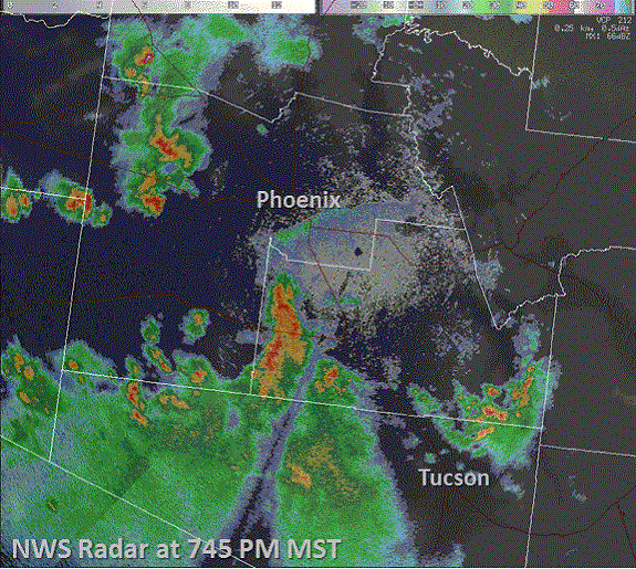
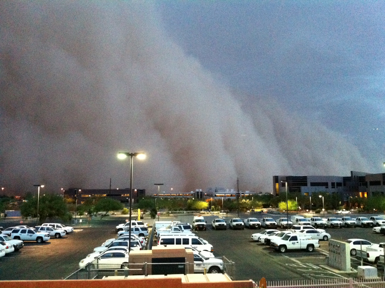 Image taken at 745 PM looking south toward South Mountain from the NWS Phoenix office in Tempe (near Priest & Washington) as the large dust storm approached.
Strong to severe thunderstorms developed east of Tucson, AZ during the afternoon hours of July 5, 2011. The storms intensified as they progressed west into the Tucson Metropolitan Area, producing downburst winds in excess of 70 MPH (110 KPH). Aided by gravity (Tucson is approximately 1500 ft/460 m higher than Phoenix) and additional downbursts from the parent storms, these strong outflow winds proceeded to race off to the northwest, with the leading edge moving at 30 to 40 MPH (45 to 65 KPH). By 630 PM (0130 UTC) the first calls came in to NWS Phoenix that a large wall of dust was approaching the Casa Grande/Eloy, AZ area, roughly 50 mi (75 km) southeast of Downtown Phoenix.
Another important factor that led to this significant dust storm was the on-going drought across the region. The most recent U.S. Drought Monitor placed the area between Tucson and Phoenix in D1 (Moderate) to D3 (Extreme) drought. Rainfall since the end of the last summer has been less than 50% of normal.
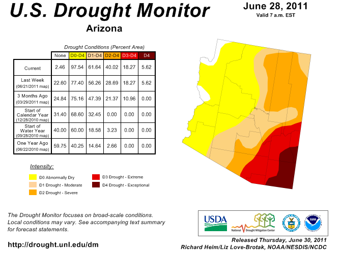
Drought levels across Arizona prior to the dust storm, ranging from extreme drought near Tucson to moderate drought closer to Phoenix.
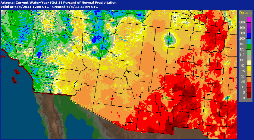
Percent of normal rainfall across Arizona since October 1, 2010.
The Delivery
At 7 PM MST (02 UTC) the leading edge of the massive dust storm hit the far southeast portions of the Phoenix area. The dust continued to push further and eventually through the entire metropolitan area during the next two hours. Trained spotters inundated NWS Phoenix with reports of literally zero visibility and winds gusting 30 to 50 MPH (50 to 80 KPH). A few measured wind gusts even approached 70 MPH (110 KPH).
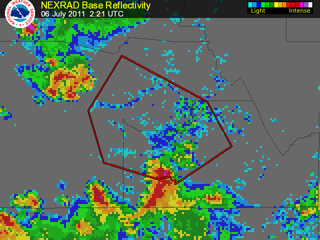
At 626 PM MST (0126 UTC) the NOAA/Storm Prediction Center issued a Severe Thunderstorm Watch for Maricopa and Pinal Counties, including the Phoenix Metropolitan Area, until 11 PM MST (06 UTC). NWS Phoenix issued the Local Dust Storm Warning 632 PM MST (0132 UTC) for the areas southeast of Phoenix, expanding the warning for the East Valley of Phoenix at 655 PM MST (0155 UTC) and nearly all of the Phoenix area at 721 PM MST (0221 UTC). Additional Local Dust Storm Warnings were issued as the dust cloud rolled west of the Phoenix area.
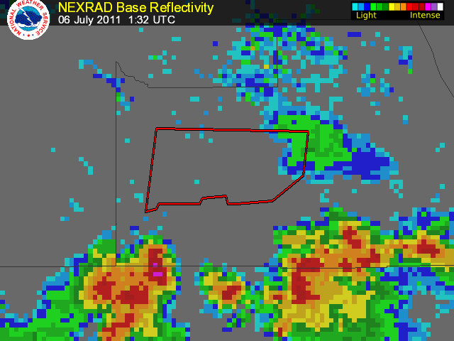
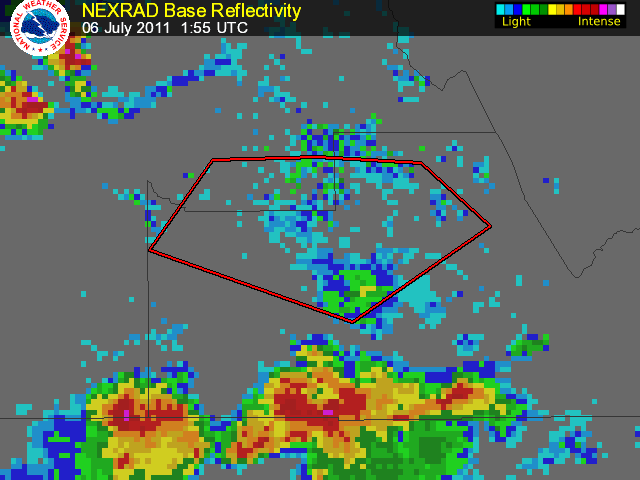
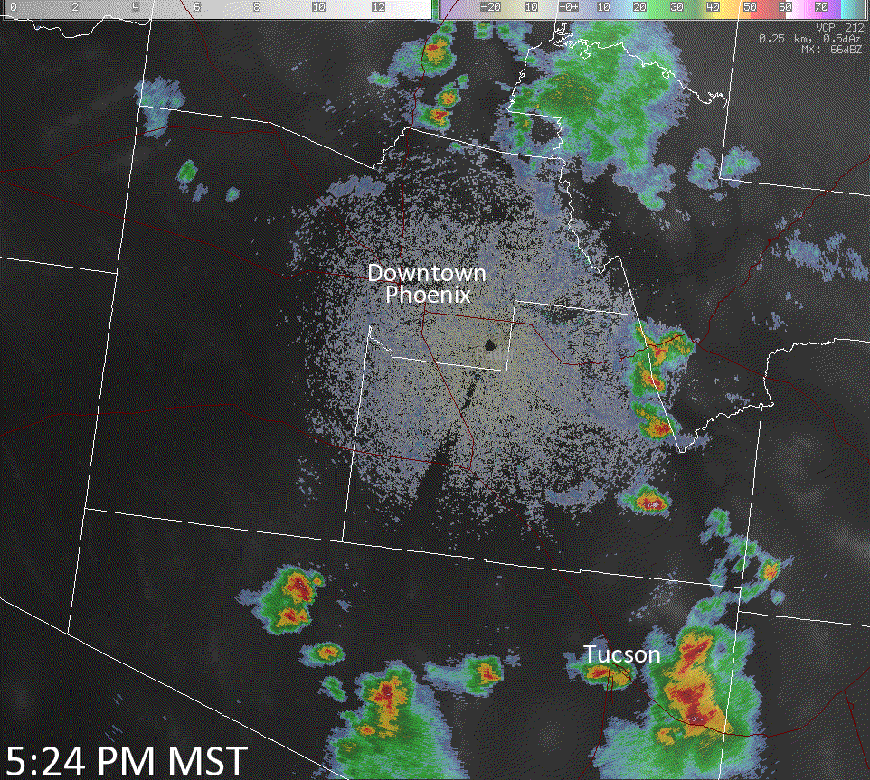
NWS Phoenix meteorologists are keenly aware that strong to severe thunderstorms in the Tucson area, given the right atmospheric conditions, are capable of producing dust storms in the area from Tucson northwest into Phoenix. Key to detecting dust storms is doppler radar and trained spotters on the ground. The lowest elevation radar data available to meteorologists in the area between Phoenix and Tucson is roughly 4,000 ft (1200 m) above the ground, making initial detection of the dust storm difficult. In addition, radar data do not inform the meteorologist as to how dense (i.e. how low the visibility) the dust is. Fortunately over the years a number of private citizens have become trained storm spotters in the area, acting as the eyes on the ground for the NWS (not just in Arizona, but across the country). Initial reports in Eloy, AZ of a significant dust storm approaching from the southeast were quickly acted on. NWS radar soon confirmed the location and expanding area of the dust storm (see images below). Doppler radar data indicated widespread winds in excess of 40 to 50 MPH (60 to 80 KPH) as the cloud rolled northwest.
NWS radar image at 745 PM (0245 UTC) of the expansive dust storm as it moved into the Phoenix area.
Click here for an animated radar loop (20 MB). Click here for an animated radar loop (19 MB).
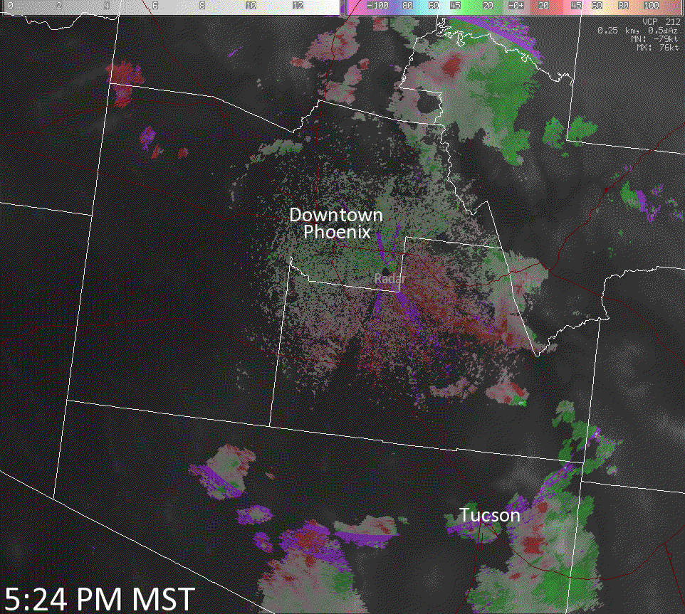
This dust storm did allow NWS Phoenix meteorologists to see how the new dual polarization (dual-pol) capabilities of the NWS Phoenix radar may help. It is noted that looking at the dual-pol variable correlation coefficient, the signal was very low along and behind the leading edge of the dust storm. It is not known yet whether this is a signature of all dust storms or just intense ones as this is the first dust storm to be sampled by the new dual-pol radar.
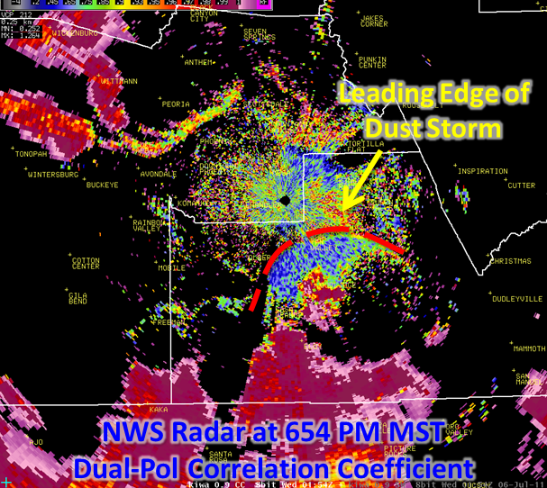
NWS Phoenix radar image at 6:54 PM MST (0154 MST) of the approaching dust storm, this time looking at the dual polarization variable correlation coefficient.
The immediate impacts were wide and many. Local media covered the dust storm extensively as it occurred, showing direct impacts to the area's transportation system. Traffic on area roadways and highways crawled to a stop in most areas. Air traffic into and out of Phoenix Sky Harbor International Airport was stopped for 45 minutes. Reports of broken large branches and trees blown down were noted. No estimate at the time was available as to the negative costs associated with this event, though they were likely substantial due to noted infrastructure damage and delays caused across a large area and through a wide swath of the local society.
Clean-up quickly began the following day as the entire city was coated in a layer of dust. Included in the clean-up were car washes, swimming pools, streets, and buildings. No estimate was available as to the positive costs associated with this event.
The dust storm in Phoenix quickly generated intense and international interest. NWS Phoenix meteorologists conducted over 40 interviews with local, national, and even international media outlets. A quick search showed over 1,000 news articles and blog postings hit the web within 24 hours of the event.
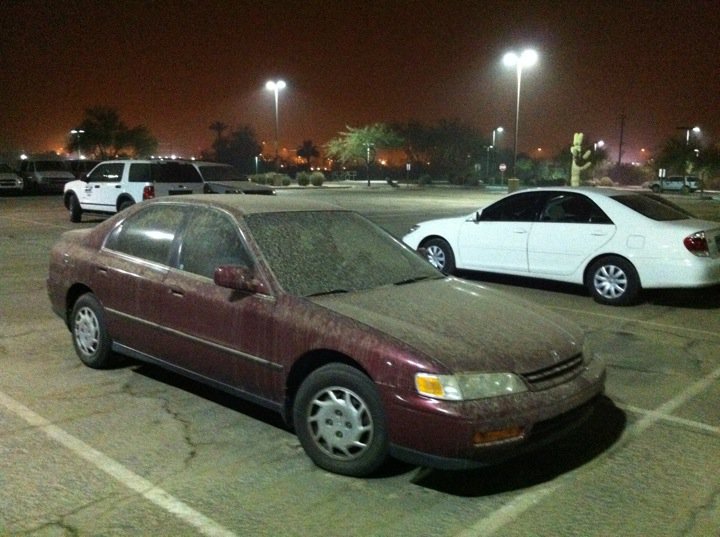
A dusty NWS employee's car. Note that the air remained hazy, nearly three hours after the dust storm moved through.
Dust storms are a common phenomenon across the Sonoran Desert in the Southwest U.S. during the North American Monsoon. During an average year, generally one to three dust storms will move into the Phoenix area - predominantly from the southeast. Across all of Arizona, over 100 dust storms have been reported in the past 10 years according to NCDC Storm Data. While records of most widespread, most intense, largest, etc., dust storms are not kept, NWS meteorologists that have worked in Phoenix for almost 30 years have said this was one of the most significant dust storms they have experienced.
A dust storm usually arrives suddenly in the form of an advancing wall of dust and debris which may be miles long and several thousand feet high. They strike quickly, making driving conditions hazardous. Blinding, choking dust can reduce visibility to near zero in just one to two minutes, causing accidents that may involve chain collisions, creating massive pileups. Dust storms usually last only 10 to 30 minutes, though dusty conditions may remain for some time afterward.
If dense dust is observed blowing across or approaching a roadway, pull your vehicle off the pavement as far as possible, stop, turn off lights, set the emergency brake, take your foot off of the brake pedal to be sure the tail lights are not illuminated. In the past, motorists driving in dust storms have pulled off the roadway, leaving lights on. Vehicles approaching from the rear and using the advance car's lights as a guide have inadvertently left the roadway and in some instances collided with the parked vehicle. Make sure all of your lights are off when you park off the roadway. Don't enter the dust storm area if you can avoid it. If you can't pull off the roadway, proceed at a speed suitable for visibility, turn on lights and sound horn occasionally. Use the painted center line to help guide you. Look for a safe place to pull off the roadway. Never stop on the traveled portion of the roadway.

