An area of low pressure moved into northern Mexico on Wednesday, May 9th providing the necessary ingredients for strong to severe thunderstorms across much of central and southern Arizona. The southern location and strength of this low pressure system was rather unusual for the beginning of May and allowed much richer moisture to be pulled northwest from Texas and New Mexico. This created an environment favorable for thunderstorms that lead to small hail, brief heavy downpours, strong gusty downburst winds, and extensive blowing dust.
Storms initially began in far southeast Arizona near Douglas, and quickly spread to the west and north during the late morning and early afternoon hours. These thunderstorms created the first of several dust storms in southern Arizona. Additional thunderstorms erupted along both the Mogollon Rim and the I-10 corridor between Tucson and Phoenix. Both these clusters of storms converged in the east Phoenix suburban communities late Wednesday afternoon and early evening. Areas of blowing dust with visibilities less than one quarter mile were common as winds gusts were upwards of 50 mph. Some localized areas had wind gusts over 60 mph causing minor damage to trees, power lines, and mobile homes.
Various storm spotter reports came into the National Weather Service Phoenix's office with damage reports of power lines down and mobile homes that had structure damage.
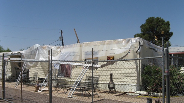
Image taken from the Pleasant Valley Mobile Home Park near Ironwood and Germann Roads, in the San Tan Valley.
More damage photos from Thursday May 10 damage survey from National Weather Service Phoenix.
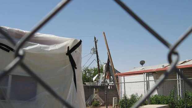
Power poles leaning to the southwest, south of the line of mobile homes that were damaged.
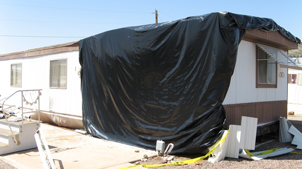
Brown mobile home with black tarp covering damaged roof.
Damage Survey
Public Information Statement
National Weather Service Phoenix AZ
1225 pm MST Thu May 10 2012
Damage survey results from East of Queen Creek...
On the morning of May 10, staff from the National Weather Service in Phoenix surveyed the damage in northern San San Valley, east of Queen Creek. Based on the damage, it appears a downburst (possibly enhanced by a gustnado) was responsible.
Damage occurred to approximately eight mobile homes in the Pleasant Valley Mobile Home Park. Six of the damaged mobile homes had their Northeast-facing awnings removed. It appeared that the wind got under the overhangs, peeled the overhangs up, and in some cases removed portions of the roofs. Many of the damaged mobile homes were also pushed to the west off of their piers.
While the damage indicated winds mainly from a single direction, storm photos and videos also showed the presence of multiple gustnadoes in the valley. A gustnado is a ground-based circulation that sometimes forms along strong gust fronts and outflow areas. Gustnadoes can extend several hundred feet into the air and can last for up to several minutes.
A gustnado can produce a rotating dust cloud that moves along the ground. However, gustnadoes are not connected to the base of the thunderstorm cloud...and therefore are not considered true tornadoes.
Gustnadoes can produce winds in excess of 60 mph, and can be responsible for locally-enhanced areas of damage. It is possible that a gustnado locally enhanced the winds and the damage in the Pleasant Valley park.
National Weather Service Phoenix is on the internet at Weather.gov/phoenix
&&
Woodall/Dewey
Storm Reports and Radar Imagery
A summary report of all of the Local Storm Reports (LSR) that were received by storm spotters and issued from the Phoenix office are listed below.
PRELIMINARY LOCAL STORM REPORT...SUMMARY
NATIONAL WEATHER SERVICE PHOENIX AZ
1046 PM MST WED MAY 09 2012

..TIME...   ...EVENT...      ...CITY LOCATION...     ...LAT.LON...
..DATE...   ....MAG....      ..COUNTY LOCATION..ST.. ...SOURCE....
            ..REMARKS..

0355 PM     HAIL             5 E QUEEN CREEK         33.24N 111.56W
05/09/2012  E0.25 INCH       PINAL              AZ   TRAINED SPOTTER

0400 PM     DUST STORM       3 S COOLIDGE            32.94N 111.53W
05/09/2012                   PINAL              AZ   TRAINED SPOTTER

            VSBY 1 8 MILE

0400 PM     DUST STORM       6 NNW CASA GRANDE       32.97N 111.77W
05/09/2012                   PINAL              AZ   TRAINED SPOTTER

            ONE EIGHTH MILE VISIBILITY...35 MPH GUSTS

0405 PM     DUST STORM       5 NE CASA GRANDE        32.94N 111.67W
05/09/2012                   PINAL              AZ   TRAINED SPOTTER

            VSBY 1 4 MILE

0416 PM     HAIL             QUEEN VALLEY            33.30N 111.29W
05/09/2012  E0.25 INCH       PINAL              AZ   TRAINED SPOTTER

0420 PM     HAIL             1 E APACHE JUNCTION     33.40N 111.53W
05/09/2012  E0.25 INCH       PINAL              AZ   TRAINED SPOTTER

0420 PM     DUST STORM       5 NE SAN TAN VALLEY     33.23N 111.52W
05/09/2012                   PINAL              AZ   TRAINED SPOTTER

            VISIBILITY LESS THAN ONE EIGHTH MILE...GUSTS TO 40 MPH.

0427 PM     DUST STORM       4 S GILBERT             33.27N 111.76W
05/09/2012                   MARICOPA           AZ   TRAINED SPOTTER

0435 PM     TSTM WND DMG     5 E QUEEN CREEK         33.24N 111.56W
05/09/2012                   PINAL              AZ   TRAINED SPOTTER

            MOBILE HOMES OFF FOUNDATIONS. POWER LINES DOWN. GERMAIN
            AND IRONWOOD.

0437 PM     HAIL             APACHE JUNCTION         33.41N 111.55W
05/09/2012  E0.25 INCH       PINAL              AZ   TRAINED SPOTTER

0438 PM     TSTM WND DMG     2 W GILBERT             33.33N 111.80W
05/09/2012                   MARICOPA           AZ   TRAINED SPOTTER

            SMALL TREES AND LARGE LIMBS DOWN OVER ROADWAY. RAY AND
            COOPER.

0500 PM     TSTM WND GST     4 N MARICOPA            33.12N 112.05W
05/09/2012  M58 MPH          PINAL              AZ   OTHER FEDERAL

0515 PM     HEAVY RAIN       EAST MESA               33.42N 111.69W
05/09/2012  M0.91 INCH       MARICOPA           AZ   TRAINED SPOTTER

            MEASURED AT GUADALUPE CHANNEL ALERT SITE. LOCALIZED
            STREET FLOODING ON BROADWAY BETWEEN SOSSAMON AND 80TH
            STREET.

0615 PM     TSTM WND DMG     GILA BEND               32.95N 112.69W
05/09/2012                   MARICOPA           AZ   UTILITY COMPANY

            TREE DOWNED THAT BLOCKED TRAFFIC ON PIMA RD AND HIGHWAY
            85. CONSTRUCTION DEBRIS FROM INTERSTATE 8 AND BYPASS 85
            ROUTE STREWN AROUND. MOST OF THE TOWN OF GILA BEND
            WITHOUT POWER. ONE POWER LINE SNAPPED DUE TO WIND.
            SUSTAINED WINDS OVER 45 MPH. NO ESTIMATE ON WIND GUSTS.

0616 PM     DUST STORM       GILA BEND               32.95N 112.69W
05/09/2012                   MARICOPA           AZ   MESONET

            ZERO VISIBILITY WITH BLOWING DUST AT KGBN. WINDS OF 44
            MPH GUSTING TO 56 MPH.
|
Correlating with the local storm reports received and the radar imagery, the best guess for the time of damage to the mobile homes would be around 4:24-4:35pm.
This radar image shows county lines (in white) and the location of the Phoenix (KIWA) radar. To the right (East) of the radar, a yellow dot along with the word 'Home' is the approximate location of the mobile home park at Ironwood and Germann roads just east of Queen Creek. At the estimated time of damage and the onset of the gustnado and downburst winds, this image shows wind speeds around 60-65 mph.
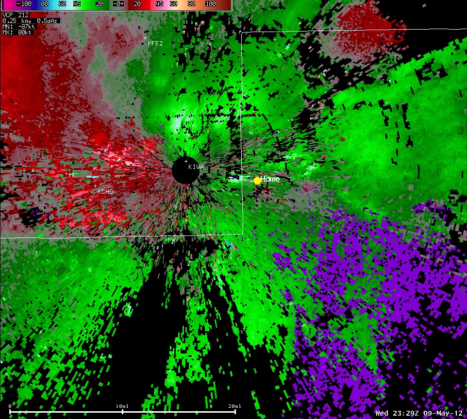
A velocity radar image from the Phoenix radar at 4:29pm MST Wednesday May 9, 2012.
The first image is the reflectivity radar image for the same time, 4:29pm on Wednesday May 9th, the second is about nine minutes later at 4:38pm.Showing thunderstorms approaching from the north and east as well as dust moving towards the Phoenix area from the southeast.
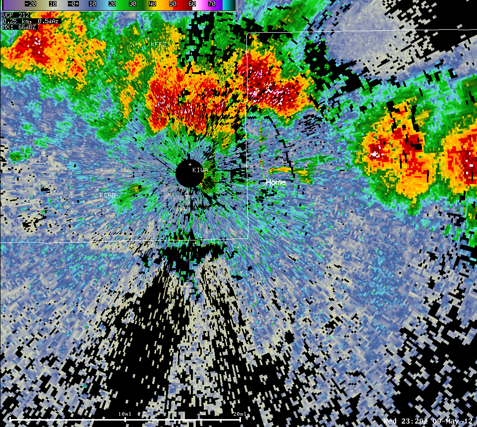
A reflectivity radar image from the Phoenix radar at 4:29pm MST Wednesday May 9, 2012.
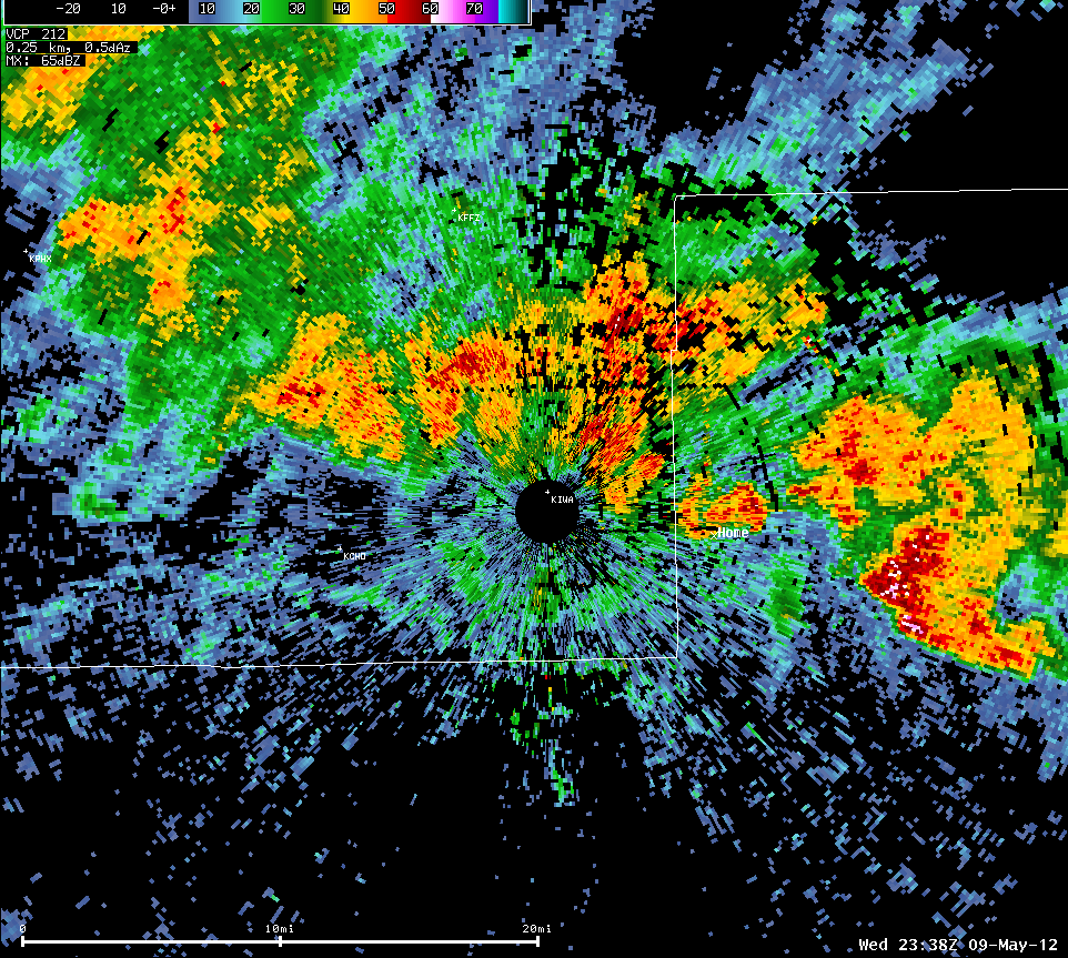
Another reflectivity radar image from 4:38pm MST. Thunderstorms have moved over the Queen Creek area and across most of the East Valley.
Animated loop of radar imagery as the storms moved through from the northeast to the southwest. Loop is from 4:19pm to 4:57pm MST.

